A History of the County of Lancaster: Volume 8. Originally published by Victoria County History, London, 1914.
This free content was digitised by double rekeying. All rights reserved.
'Cockersand Abbey', in A History of the County of Lancaster: Volume 8, ed. William Farrer, J Brownbill (London, 1914), British History Online https://www.british-history.ac.uk/vch/lancs/vol8/pp105-106 [accessed 30 April 2025].
'Cockersand Abbey', in A History of the County of Lancaster: Volume 8. Edited by William Farrer, J Brownbill (London, 1914), British History Online, accessed April 30, 2025, https://www.british-history.ac.uk/vch/lancs/vol8/pp105-106.
"Cockersand Abbey". A History of the County of Lancaster: Volume 8. Ed. William Farrer, J Brownbill (London, 1914), British History Online. Web. 30 April 2025. https://www.british-history.ac.uk/vch/lancs/vol8/pp105-106.
In this section
COCKERSAND ABBEY
Extra-parochial
Kokersand, 1212; Cocressand, 1213.
The abbey demesne occupies 345½ acres, (fn. 1) and the population of the township in 1901 was 53. It is often regarded as belonging to the township of Thurnham. A small detached part of Pilling, in Cockerham parish, was added to it in 1887. (fn. 2)
The soil is various, overlying clay. The site of the abbey was described by Leland as 'standing very bleakly and object to all winds.' (fn. 3) There are two lighthouses to regulate the navigation of the Lune.
Abbey
The story of this house of canons regular, founded 1180–90, has been related in a previous volume of the present work. (fn. 4) The site was taken from Cockerham and Thurnham, and several agreements were made with the Abbot and canons of Leicester respecting its boundaries, (fn. 5) as well as concerning the tithes of Forton. Very little of the building remains.
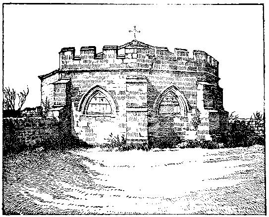
The Chapter-house, Cockersand Abbey
Cockersand Abbey stood in a very exposed and bleak situation close to the seashore (fn. 6) on a piece of land that juts out between the estuaries of the Lane and the Cocker, overlooking Cockerham Sands. All that now remains is the chapter-house and portions of the nave walls and eastern walls of the north and south transepts, and various scattered fragments of masonry, which give a general indication of the extent of the conventual buildings. A careful and complete excavation of the site has yet to be made, and until this is done little can be said with any degree of certainty about the plan of the original buildings. They appear, however, to have been built in the usual way round a cloister garth about 80 ft. square, with the church on the north side and the chapter-house on the east. The masonry that remains above ground is all of local red sandstone, now very much worn where exposed, and there are numerous stones which formerly belonged to the building scattered about the ground and others built into the fence walls of a neighbouring farm-house. The chapter-house is an excellent example of 13th-century work, octagonal in plan, measuring internally 27 ft. 6 in. in diameter, with a vaulted roof carried on a central shafted pillar. Externally it has been a good deal rebuilt, and has a modern embattled parapet on the east side. On the west the building is rectangular outside, and the wide round-headed doorway opening is partly built up with modern filling. The roof was slated about 1859, (fn. 7) having previously been covered with lead, and is surmounted by a modern cross. The walls are 2 ft. 10 in. thick, and externally are 13 ft. 6 in. high, with pointed windows on the three sides facing east and buttresses of three stages at the angles. The chapter-house was used about the middle of the 18th century (fn. 8) as a place of burial by the Dalton family and so continued till 1861, when Miss Dalton was interred there; the walls and floors now contain numerous inscribed stones to members of the family. (fn. 9)
The detail of the interior, not having been exposed to the weather, is still in a very good state of preservation, though in places filled up with cement and dirt, and has been at some time whitewashed all over. The vault springs at a height of 4 ft. 6 in. above the present floor from the centre pier and from moulded angle shafts, and is 13 ft. 6 in. high at its highest point. The floor, however, appears to have been raised, (fn. 10) no moulded base to the pier being visible. The walls are arcaded all round; the openings in the north and south, which were apparently originally doorways, are now entirely built up, and the windows facing east are built up to the height of the springing of the arches. On the west side the walls appear to have always been solid, and the arcading to have been, as now, merely an ornamental feature carrying on the design round the building. The arches are pointed, 4 ft. 9 in. in width, and of three moulded orders and hood mould, springing from angle shafts 4 ft. 3 in. high, with moulded capitals and bases. On the west side there is a trefoiled inner arch. The hood moulds are stopped with carved heads, but externally, where the arch is of a single moulded order, they are merely returned. The central pier has eight rounds and fillets deeply undercut, and the capital is carved with foliage, into which two small heads are introduced. The vaulting ribs have the roll and triple fillet and the bosses are carved with foliage. The whole is a very good piece of Gothic work, and the effect of the whitewash, now old and flaking, is to give it the appearance of being built of white or yellow stone.
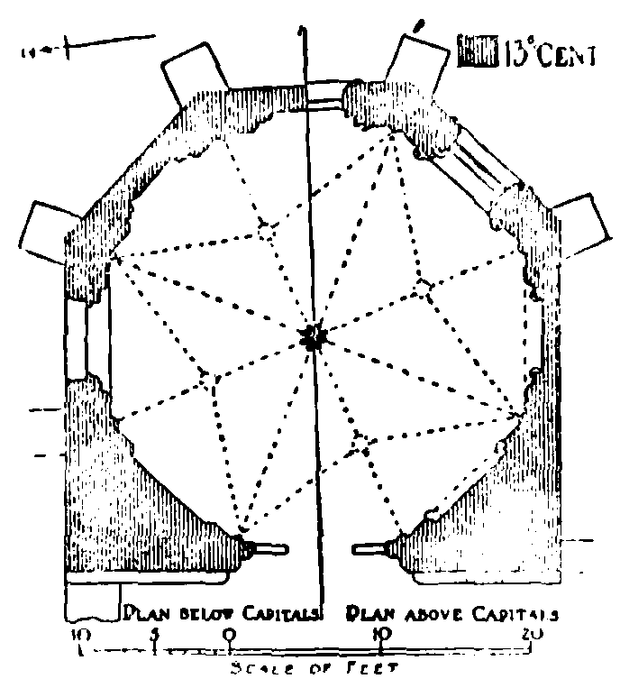
Plan of Chapter-house, Cockersand Abbey
To the north of the chapter-house an external wall, 3 ft. thick, with ashlar facing and two buttresses of 9 in. projection, runs northward a distance of about 23 ft., beyond which it is continued with rubble facing a total distance of 82 ft. The height of this wall is now 4 ft. 6 in. for the greater part of its length, but at the far end, where it turns for a short distance at right angles to the west, it reaches a height of 10 ft. Most of the other fragments of walling scarcely show more than above the ground, but there is an isolated fragment about 70 yds. to the south-west of the chapter-house, standing close to the sea, which is 11 ft. in height.
The site was in 1543 granted by the Crown to John Kitchen. (fn. 11) It passed to the Daltons, (fn. 12) and has ever since descended with Thurnham.