A History of the County of Middlesex: Volume 3, Shepperton, Staines, Stanwell, Sunbury, Teddington, Heston and Isleworth, Twickenham, Cowley, Cranford, West Drayton, Greenford, Hanwell, Harefield and Harlington. Originally published by Victoria County History, London, 1962.
This free content was digitised by double rekeying. All rights reserved.
'Twickenham: Introduction', in A History of the County of Middlesex: Volume 3, Shepperton, Staines, Stanwell, Sunbury, Teddington, Heston and Isleworth, Twickenham, Cowley, Cranford, West Drayton, Greenford, Hanwell, Harefield and Harlington, ed. Susan Reynolds (London, 1962), British History Online https://www.british-history.ac.uk/vch/middx/vol3/pp139-147 [accessed 30 April 2025].
'Twickenham: Introduction', in A History of the County of Middlesex: Volume 3, Shepperton, Staines, Stanwell, Sunbury, Teddington, Heston and Isleworth, Twickenham, Cowley, Cranford, West Drayton, Greenford, Hanwell, Harefield and Harlington. Edited by Susan Reynolds (London, 1962), British History Online, accessed April 30, 2025, https://www.british-history.ac.uk/vch/middx/vol3/pp139-147.
"Twickenham: Introduction". A History of the County of Middlesex: Volume 3, Shepperton, Staines, Stanwell, Sunbury, Teddington, Heston and Isleworth, Twickenham, Cowley, Cranford, West Drayton, Greenford, Hanwell, Harefield and Harlington. Ed. Susan Reynolds (London, 1962), British History Online. Web. 30 April 2025. https://www.british-history.ac.uk/vch/middx/vol3/pp139-147.
TWICKENHAM
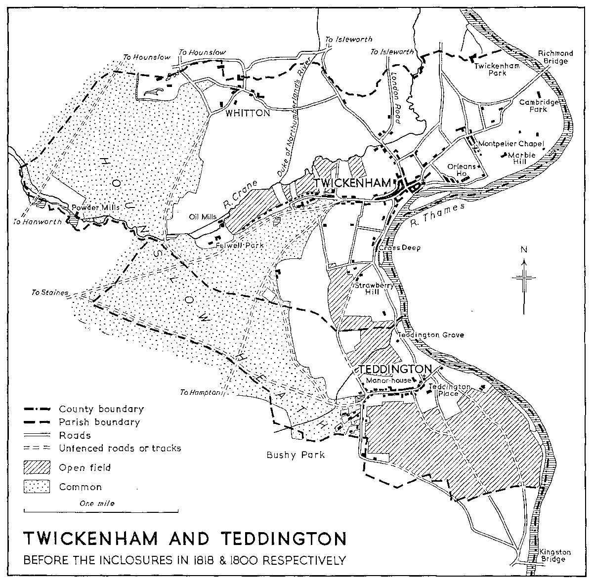
The old parish of Twickenham (fn. 1) has since 1937 been part of the borough of Twickenham, which also includes virtually all of the former parishes of Teddington, Hampton Wick, and Hampton. The only recorded change in the parish boundary before 1937 occurred in 1934. (fn. 2) Before then the ancient parish consisted of 2,421 acres, forming a broad wedge stretching westward from the Thames, which here runs north from Kingston to Brentford, to Hounslow Heath. In the west the ground rises to over 50 feet, but elsewhere it is lower and on the whole very flat. (fn. 3) Except for a thin strip of alluvium along the river and two patches of brick-earth, the soil is all gravel. One patch of brick-earth lies east of Whitton and the other covers the old village site and stretches a little way north-east from it. The rest of the parish is covered with Taplow gravel to the west of Whitton on the old heath-land, and with flood-plain gravel to the east. (fn. 4)
The river makes a double curve past Twickenham, with several islands and, formerly, a number of fishweirs in its length. A small tributary stream formerly marked part of the southern or upstream boundary, most of which crossed Hounslow Heath and the fields of Twickenham and Teddington without following any apparent natural features. Another stream ran into the Thames a little lower down at Cross Deep, where there are two aits, though one of them had become nearly joined to the mainland by the present century. (fn. 5) This stretch of the river, above Twickenham village, seems to have constituted one of the fisheries belonging to Isleworth manor, called Stoke Weir fishery. (fn. 6) There were several weirs in this reach in the 18th century, most of them illegal. (fn. 7) On the outside of the curve at Twickenham village is Eel Pie Island, or Twickenham Ait, which was three separate islands in 1607. (fn. 8) A footbridge to the island was built in 1957. (fn. 9) Lower down was another ait which was joined to the mainland by the owner of Orleans House about 1847. (fn. 10) Glover's Island lies on the next curve and three more aits lie below Richmond Bridge: in both places there were two islands in the 18th century. (fn. 11) There were several fisheries below Twickenham village. One fish-weir, perhaps that generally known in the Middle Ages as Petersham weir, (fn. 12) still stood in the middle of the river in the mid-18th century (see plate facing p. 143). In the 15th century there was also a wheel for taking fish opposite Twickenham Park. (fn. 13) The River Crane runs right across the parish, marking the western part of its south boundary, and joins the Thames farther north in Isleworth. Parts of its course through Twickenham have been slightly altered in the present century. (fn. 14) A tributary to it divided Twickenham from Isleworth along most of the northern side of the parish. (fn. 15) The only other considerable water-course in Twickenham is a short stretch of the Duke of Northumberland's River, which was constructed in the 16th century to run north from the Crane near Twickenham Green. (fn. 16)
There was a settlement at Twickenham by 704, (fn. 17) probably on the slightly higher ground by Twickenham Ait where the village stood in later times. (fn. 18) It is likely that the church stood on its present site by the late 11th century, and that the medieval village was clustered round it along Riverside, in Church Street and King Street, in the alleys leading from them down to the river, and at the bottom of London Road. (fn. 19) The name of Burgate was applied to part of the town close to the church in 1486. (fn. 20) In 1635 the archery butts stood at the eastern entrance to the town in Richmond Road.
In 704 the lands of Twickenham all lay to the south of the Crane. (fn. 21) Later, there were common meadows on the river-bank east of the village, (fn. 22) and behind them was open-field land which stretched to Isleworth, unbroken except by the 13th-century manorial park on the parish boundary by the river. (fn. 23) Later in the Middle Ages, though apparently not in 704, this field extended over the Crane, and possibly reached as far as the smaller fields to the north-west of the town. Another stretch of open field lay along the river to the south of the town. It was broken in 1635 by meadowland along the stream at Cross Deep, and south of that the field went on again to join the open fields of Teddington. Farther west a triangle of heathland ran from Teddington Common and the main area of Hounslow Heath up to Twickenham Green. By the 17th century a small hamlet called Heath Row stood on the edge of the common, linked to the main village by buildings along Heath Road. Between this common and the Crane there were open fields in the Middle Ages, and in the west the common was joined across the Crane to the main expanse of Hounslow Heath on the west side of Whitton. Whitton may have been in existence in 704 as a separate settlement claiming all the lands north of the Crane, but it is not named until the late 12th century, when assarts were being made from the common beside the Crane to the south of the hamlet. (fn. 24) As late as the 17th century most of Whitton's fields lay to north, east, and south, with comparatively small clearances from the heath on the west. Apart from a few larger houses to be described later the hamlet consisted of cottages grouped round several lanes where the road coming across the fields from the east (Whitton Road-Kneller Road) met that which ran along the edge of the heath from Hounslow over Whitton Bridge (later Hospital Bridge) to Hanworth.
None of the roads in the parish was of the first importance and it was probably the position of the settlements that determined their course. The chief was the road which ran from the London-Hounslow road through Isleworth to Twickenham, and so by Strawberry Vale to Teddington and Kingston. There was a stone bridge over the Crane on the London Road by 1636. (fn. 25) This road was turnpiked in 1767: (fn. 26) Horace Walpole described the part by Strawberry Hill in 1753 as having 'coaches, post-chaises, waggons, and horsemen constantly in motion'. (fn. 27) Part of the traffic on this stretch no doubt came from the Richmond Road, which was the parish's other main road. There was a ferry near the site of Richmond Bridge by 1439. (fn. 28) It was said to have declined in use after Sheen Palace was demolished. If this was so, it revived later, partly no doubt as a result of the accession of fashion to the neighbourhood in the 17th and 18th centuries. It was replaced by a bridge in 1777, and the road was slightly diverted accordingly. (fn. 29) The Richmond Road could also serve as an alternative way from London, meeting the Isleworth road at Twickenham and then branching to Staines and Hampton just outside the town. Between them, these two roads no doubt helped to support the nineteen inns and ale-houses which the parish contained in 1800: (fn. 30) three of them were said in 1822 to supply horses. (fn. 31) The other roads were little more than tracks linking the villages round about. Hospital Bridge, over the Crane, probably took its name from the hospital attached to James II's military camp nearby on the heath. (fn. 32) It had formerly been called Whitton Bridge. (fn. 33) Some owners of larger houses made a few small diversions in the roads from the 17th century on, (fn. 34) and the course of the roads over the heath was not finally determined until its inclosure in 1818, but otherwise the pattern was more or less established by 1635. (fn. 35) Twickenham Ferry, however, crossing the Thames at the lower end of Eel Pie Island, seems to have been started between then and 1659. (fn. 36) This was the only river crossing in the parish above Richmond Bridge until modern times. About 1909 the owners of a boat-hiring business started carrying footpassengers over at Marble Hill, and by this time there was also a foot-ferry at Cambridge Park. (fn. 37) Until 1780 the Thames towpath was on the Middlesex side below Richmond Ferry, and was then transferred to Surrey. (fn. 38)
By 1635, when Moses Glover made his map of Isleworth hundred, changes had been made from what may be inferred of the medieval geography of the parish. Some inclosures on the edge of the common south of Whitton seem to have been made in 1562 under Henry VIII's largely ineffective Act for inclosing Hounslow Heath, though they may not have been maintained later. (fn. 39) Three warrens, two on the edge of the heath and one by the river, had also been planted, possibly quite recently. (fn. 40) Much of the inclosed land around the open fields and to the east of Whitton may have been inclosed during the later Middle Ages, and in the next century and a half most of the remainder was inclosed piecemeal and converted to market-gardens and orchards or to pleasure-grounds for the big houses which were being built around the village. In 1818 the remaining open fields were inclosed: South Field then contained 51 acres and several small fields north of Staines Road and Heath Road contained together 57 acres. The common was also inclosed, comprising 492 acres on the heath proper and 173 on the Little Common south of the Crane. (fn. 41)
By 1723 Twickenham was 'a village remarkable for an abundance of curious seats'. (fn. 42) Persons of fashion seem to have started coming there over a century before and a number of houses were built for them during the 17th century, though in most cases the exact dates are unknown. The profusion of villas in the next century became such that it is intended here only to suggest the stages by which they spread along the river and around the town and common, and to indicate which were the more notable. (fn. 43)
TWICKENHAM AND TEDDINGTON before the inclosures in 1818 & 1800 respectively
The house in Twickenham Park, which is discussed elsewhere, (fn. 44) was perhaps the first in which lived members of the upper classes from outside the parish. Francis Bacon lived there for some time in the late 16th century, and Lucy, Countess of Bedford (d. 1627), patron of the poet, John Donne, in the early seventeenth. By 1635 the manor-house, York House, a house near the site of the later Orleans House, and at least one at Whitton were in the hands of members of the upper classes who are not known to have had any former connexion with Twickenham. (fn. 45) The bailiff of Isleworth manor (fn. 46) lived at Whitton, and the steward (fn. 47) lived on the corner of Cross Deep and Heath Road in a house which, according to a tradition current in 1872, was the first house in the parish to have glazed windows. (fn. 48) In 1635 the site of the later Cambridge House by Richmond Ferry was also occupied by a member of the aristocracy whose house had probably been built there not long before: (fn. 49) this seems to have been the first of the villas to be built on a site which had not been occupied in the Middle Ages by a house set there for other than aesthetic reasons. The grounds of this house were enlarged in the 17th century, as many of the others were to be in the 18th, by inclosures from the open field, and also by the diversion of the Richmond Road. (fn. 50) In 1669 it was said that many houses had been built on the east of the town in the preceding thirty or forty years, and more appeared soon afterwards. (fn. 51) The farm-house near Orleans House was rebuilt on its later site in the mid17th century and there were houses on the sites of Mount Lebanon and Riverside House by the 18th, if not before. (fn. 52) The Mount Lebanon house was rebuilt and much enlarged about 1702, (fn. 53) the later Orleans House was rebuilt in 1710, and the Octagon was added some years later. (fn. 54) This last house, which is discussed further elsewhere, Macky considered to be the finest in Twickenham because of its splendid gardens. (fn. 55)
By about 1720 (fn. 56) the demand for houses was apparently great enough to justify the building of the two terraces known as Montpelier Row and Sion Row. Montpelier Row (see plate facing p. 142) was speculatively built by a Captain John Gray and the houses were leased until after his death. (fn. 57) They have three stories and basements, and are built of brown and red brick. Though some have been altered and a Victorian terrace has been inserted between the two original groups, the general appearance as well as many of the details, which include original doorcases and iron-work, remains little changed. There is no evidence to show who built Sion Row, though the same builder may have been responsible for it and for some houses on the Embankment. Sion Row is dated 1721: (fn. 58) the houses are smaller than those in Montpelier Row, and have had fewer distinguished inhabitants, but like the others they preserve much fine work. Together with the surviving later-18thand early-19th-century houses along Riverside, the two terraces form a small but authentic part of the old Twickenham. In the 18th century, however, there was open grass between the river and the road running in front of the Riverside houses, so that the parkland of Marble Hill and Orleans House appeared to continue right into the village. (fn. 59) Marble Hill, which George II's mistress, Henrietta Howard (later Countess of Suffolk), built between 1723 and 1729, (fn. 60) seems to have been the first villa in the meadows between Orleans House and Cambridge House (see plate facing p. 143). (fn. 61) It is thought to have been designed by the Earl of Pembroke in conjuction with Roger Morris, the latter probably providing the technical knowledge. (fn. 62) The building consists of a single three-story Palladian block, the three central bays having an Ionic order surmounted by a pediment. Internally there is a fine staircase and a large first-floor room overlooking the river. (fn. 63) Apart from early-19th-century modifications to some of the windows the house has survived with little alteration. It stands in something approaching its original setting, flanked by tall trees and with its lawns stretching to the river. Letitia Hawkins, the daughter of Sir John Hawkins, Dr. Johnson's biographer, who lived in the village, remarked in 1822 that Lady Suffolk's house, 'now despised as unfashionable, was one of those which contributed to give Twickenham the epithet of classic, and largely did it contribute'. (fn. 64) Richard Bentley, Horace Walpole's collaborator at Strawberry Hill nearby, designed a Gothic farm, which was called St. Hubert's Priory, for the garden of Marble Hill, but this was pulled down after Lady Suffolk's death. (fn. 65) Richard Owen Cambridge (1717- 1802), the poet and essayist, acquired Cambridge House in 1750 and laid out its grounds in the 18thcentury taste. (fn. 66) By the time this had been done the riverside below the village had attained the character which helped to make famous the view from Richmond Hill. (fn. 67)
Upstream, Richmond House, between King Street and the river, dated from between 1635 and 1708. (fn. 68) There was only one small house between the village and Cross Deep in 1635 and the first of the villas here were probably built later in the 17th century: both the house called Cross Deep and Radnor House contain work of the very end of the century or the beginning of the next. (fn. 69) Alexander Pope took his house in 1719. The statement that he pulled down eleven others to make his garden seems slightly improbable, (fn. 70) but Poulett Lodge was said to have been built on the site of a smaller house which was burned down in 1734. (fn. 71) By 1746 there was a group of houses at the north end of the road and another near the aits at Cross Deep: more houses were built along the road later. (fn. 72) Most of the 18th-century houses here were classical in style, though Radnor House had a Gothic front by 1750 and a Chinese summer-house soon after. The summer-house in an adjoining garden, which belonged to a house across the road, was also Gothic. (fn. 73) Gothic sashes were added to the windows of Cross Deep in the second half of the century. Pope's house, enlarged after his death, was a small classical building of no outstanding architectural interest (see plate facing p. 150), and it was on his garden that he bestowed particular care. Most of this lay across the road and was connected to the house by the famous grotto, which still survives in a mutilated form. Despite its limited extent (about 5 a.), or perhaps because of the way in which this was overcome by landscape-gardening, the garden, with the grotto and Pope's cherished willow-tree, attained great fame in the 18th century. The story of the changes to the garden and house after Pope's death, and of the demolition of the house in the early 19th century, has often been told. (fn. 74) It is less generally known that the classical orangery in the garden survived until about 1939. (fn. 75) The only survivors of 'Twitnam's classic shores' (fn. 76) at Cross Deep are now (1958) the house called Cross Deep, the Gothic summer-house, a small part of the garden buildings of Radnor House, (fn. 77) and one or two rather later houses.
South of the stream at Cross Deep there was in the early 18th century only the small house with 5 acres of ground which Horace Walpole rented in 1747, bought in the following year, and christened Strawberry Hill. (fn. 78) The house dated from 1698 and appears to have been a structure of no particular architectural character, (fn. 79) three rooms long and two rooms deep. Walpole started at once to alter it and by the end of 1749 had decided to convert it into 'a little gothic castle'. (fn. 80) His first architect was William Robinson of the Board of Works, but before the initial stages of the conversion were finished he had evidently decided that Robinson's work was 'not truly gothic'. Thereafter designs were supplied by Walpole's friends John Chute and Richard Bentley. Genuine medieval models were studied and freely adapted, Robinson's function being relegated to that of clerk of works. The original house lies at the south-east corner of the present mansion. Its principal features in Walpole's time, besides a new battlemented upper story, were a first-floor breakfast-room with a bay window looking east towards the river and an elaborate Gothic staircase hall. In 1754 a two-story block containing a 'great parlour' and a library was added to the north. The library had Gothic fittings designed by Chute, an heraldic ceiling, and much painted glass. By 1759 the 'Holbein chamber', a bedroom divided by a traceried screen, had been added. The subsequent additions, virtually completed by 1770, lay to the west and nearly trebled the size of the original house. The garden front is occupied by a cloister and terminates in a circular tower at the south-west angle. The whole layout is remarkable for the period in its avoidance of Georgian symmetry. A rift with Bentley in 1761 led to the employment of Thomas Pitt and later of Robert Adam. The principal first-floor rooms include the fan-vaulted gallery above the cloister, the 'tribune', with its circular ceiling copied from the chapter house at York, and the round drawing-room, of which the chimneypiece was taken from Edward the Confessor's tomb and 'improved by Mr. Adam'. The small Beauclerc tower at the west end, designed by James Essex, was added in 1776. Of the various garden features, including the building by the road which housed Walpole's printing press, only the chapel, designed by Chute and executed by Thomas Gayfere in 1772-4, survives. By 1790 the whole undertaking, apart from the pictures, furniture, and objets d'art with which the rooms were crowded, had cost over £20,000. The house became famous in its own day and has remained a landmark in the history of taste. The Gothic style, not itself uncommon in the 18th century, was here used for the first time in a deliberately antiquarian spirit and to create a romantic atmosphere (see plate facing p. 151). After Walpole's death and a life tenancy, Strawberry Hill passed to his Waldegrave relatives. The 7th earl (d. 1846), having sold the contents in 1842, left the house to his widow, Frances, Countess Waldegrave. (fn. 81) In 1856 she began a sympathetic restoration of the building which during her two subsequent marriages she used for political entertaining on a large scale. Between 1860 and 1873 she built new reception rooms to the south, connecting the original house with an office block which had been originally designed for Walpole by Essex and was completed by James Wyatt in 1790. The Gothic style used by Lady Waldegrave, although larger in scale and coarser in detail, retains some of the spirit of the earlier work. New buildings were erected in the grounds after Strawberry Hill had been acquired by St. Mary's Training College in 1927, and the house has been gradually restored. In 1958-9 a 19th-century entrance hall was demolished and the north front was rebuilt to Walpole's original design under the direction of Sir Albert Richardson. (fn. 82)
Away from the river, Copt Hall, to the north of Back Lane (now Holly Road), was probably built in the 17th century and was 'much improved' in the early eighteenth. It was said to have 'hanging gardens to the river'-presumably the Crane. (fn. 83) Several houses, of which one or two survive, were built around the London Road in the 18th century. (fn. 84) Apart from Montpelier Row, however, the most popular area away from the river was farther west. The older house on the corner of Cross Deep and Heath Road has already been mentioned. By 1723 a house which 'would pass in Italy for a delicate palace' occupied the site of Heath Lane Lodge half-way along the south side of Heath Road. (fn. 85) The grounds extended to Cross Deep, where the summer-house was visible from the river among the villas there. (fn. 86) Lady Mary Wortley Montagu took the later Saville House about 1721, (fn. 87) and Sir John Hawkins came to Twickenham House, the last before the gate to the common, in 1760. (fn. 88) It was after he settled here that Hawkins became a leading Middlesex magistrate. (fn. 89) The story told by R. S. Cobbett, the historian of Twickenham, that the Literary Club sometimes met at Twickenham House seems to be quite untrue. (fn. 90) Three middle- or upper-class houses stood on the north of Heath Road, (fn. 91) and beyond the gate were others on the edges of the common.
On the north side of the common, the hamlet around what is now Colne Road consisted largely of cottages. Building is known to have been going on there in the late 17th century. (fn. 92) Soon afterwards the almshouses (later the workhouse) were built there, (fn. 93) and the parish pound stood nearby. (fn. 94) Several streets still (1958) contain 18th-and early-19th-century buildings. The bigger houses of the gentry lay west of this hamlet: there were four of them by the late 18th century, all probably built within the preceding half-century. About 1780 their owners enlarged the pond on the common across the Staines Road to be an ornamental lake. (fn. 95) By 1818 these houses were surrounded by many smaller ones. Still farther west stood Fulwell Lodge (later Fulwell Park), which had been in existence by 1623. (fn. 96) In the mid-18th century there were three large houses by the Hampton Road on the south-east of the common. This area seems to have been the earliest to be radically altered by demolition: two of the houses disappeared in the early 19th century and the later houses were for the most part built on different sites. (fn. 97) By 1958 all the larger old houses in Heath Road and around the common had disappeared except for one (Briar House) in Colne Road.
Of the larger houses in Whitton in 1635, one belonged to Sir John Suckling, the poet, and stood to the south of the village approximately where the west end of Warren Road now runs. Between 1607 and 1635, it seems to have been much enlarged, and a park was laid out round it. A larger house to the west seems to have been pulled down in the same period. (fn. 98) In the 18th century and later there was only a farm-house or cottage on the site of Suckling's house. Another house which may have declined in status during the same period stood on or near the site of that later called Whitton Manor. (fn. 99) Exactly when these two houses sank in the social scale is unknown: Whitton had a number of notable residents in the late 17th and early 18th centuries whose houses cannot be identified. (fn. 100) The site of Kneller Hall, on the other hand, appears to have been occupied by a less important building in 1635. Sir Godfrey Kneller had alterations made to it by Vanbrugh in 1703; (fn. 101) subsequent additions and changes have, however, made the house in effect a different building, and the present appearance of the grounds also dates from a later period. (fn. 102) The last large house of 1635 had apparently been built since 1607 and stood west of Hounslow Road, nearly opposite the present church, on inclosed land projecting on the heath. It was rebuilt in 1724-5 by Roger Morris for its owner, the Earl of Ilay (later Duke of Argyll). (fn. 103) In 1726 Ilay received licence to inclose more heath around it. He subsequently laid out a park with a lake and a Gothic tower (see plate facing p. 150). (fn. 104) A later owner built a second house (Whitton Park) farther north, sold Argyll's (Whitton Place) to Sir William Chambers who altered it and then bought it back to demolished it. (fn. 105) The second house is now also gone, though the base of the Gothic folly was said to survive in 1957. (fn. 106)
By the early 19th century the Twickenham riverside, embellished with villas, was said to convey 'an idea of luxury which the utmost labours of the pen would vainly endeavour to impart'. (fn. 107) The villas multiplied in the 19th century, though the new ones were generally smaller and stood on restricted sites- conforming to the 19th-century type of villa rather than to the eighteenth. (fn. 108) Among several built northeast of the town was Solus Lodge (later Sandycombe Lodge) in Sandycombe Road, which J. M. W. Turner designed and built for himself in 1810-14. (fn. 109) Meanwhile some of the older houses were beginning to come down. (fn. 110) The Twickenham Park estate was divided in 1805 and after the house had been demolished (fn. 111) villas were built on the edges of the former park, forming a suburb rather of Richmond than of Twickenham. (fn. 112) The inclosure of 1818 was followed by a good deal of building on the common west of Twickenham Green: elsewhere its chief re sult was to bring the heath under cultivation, while orchards and market-gardens continued to spread over the previously inclosed land to the north and east. (fn. 113) The building on the common included several planned groups of small two-story stucco houses, often arranged in pairs. These were probably the first semi-detached houses to appear in the district. A good example of these groups survives in Trafalgar Road (formerly Trafalgar Square). (fn. 114) Also in this area were the Carpenters' Company almshouses (built 1841, demolished by c. 1951), (fn. 115) and Holy Trinity (1841), the first new Anglican church in the parish. (fn. 116) Between 1821 and 1841 the number of houses in the parish rose from about 740 to just over 1,000, and communication with London was provided by hourly coaches and omnibuses from the 'King's Head' and by other coaches which passed through the town. (fn. 117) Nevertheless, the great period of building awaited the coming of the railway. This was constructed from Richmond through to Staines in 1848, with a station at Twickenham approached from the south of the line west of London Road. The Kingston branch was opened in 1863 and the Thames Valley line, which joined it just inside the parish, in 1864. The curve connecting the loop line through Hounslow (built 1850) with the main line was built in 1883. (fn. 118)
By 1871 there were over 2,000 houses in the parish. (fn. 119) Before the branch line to Kingston was opened building was concentrated, as might be expected, near the station. (fn. 120) The Arragon House estate, for instance, was sold for building in 1853 (fn. 121) and by 1865 it and the roads west of the London Road were substantially built up. These were mostly small terraced working-class houses, (fn. 122) but farther west semidetached houses continued to be erected on the common and north of the Staines Road, and the large detached villas of Cambridge Park were of sufficient status to have a mews nearby. (fn. 123)
The pace of building decreased in the seventies, rising to new heights in the next decades. (fn. 124) Strawberry Hill Station, opened probably in 1872, (fn. 125) on the Kingston branch line, is said to have been primarily intended for Lady Waldegrave's numerous guests. (fn. 126) The south end of the park at Strawberry Hill had been laid out for a housing estate, named Waldegrave Park, in the sixties, but this was a failure for many years. (fn. 127) Houses had been built on the east of the railway around Pope's Avenue when the common was first being developed, but the main building here took place from the 1880's onwards. (fn. 128) In the north of the parish most of the original middle-class estate of St. Margaret's was in Isleworth, (fn. 129) but a station of that name was opened within the Twickenham boundary in 1876 (fn. 130) and has since attracted both the name and the shopping centre of the district farther south towards itself. Smaller houses joined the Cambridge Park villas and other roads were laid out and some houses were built, notably in Rosslyn Road and to the north of it, but, on the whole, riverside development on the Twickenham side of the railway was fairly gradual. The streets of small terraces meanwhile spread out from the town to meet St. Margaret's, and continued to be built on the west side of the town. (fn. 131) The first estate north of the railway seems to have been at Heathfield, by Whitton Road, and a little later, in the nineties, Cole Park was laid out with detached houses, and the smaller Perryn House estate followed. (fn. 132)
Different reasons have been given for the great increase of building around the turn of the century. (fn. 133) Of these the most usual is the starting in 1902 of the tram-service to Shepherd's Bush. (fn. 134) The trams ran along the London Road to York Street and along Richmond Road to the bridge. In 1903 the lines were extended through the town and along the Hampton Road to Teddington and Hampton. (fn. 135) The trolleybuses which replaced them in 1931 were the first to run in Middlesex. (fn. 136) The trams do not, however, seem to have had a decisive influence on the development of any district close to the line in Twickenham, (fn. 137) and many working-class houses preceded their arrival, though they undoubtedly stimulated building and provided the first really cheap route to London. (fn. 138) At all events, about 11,000 houses were built in the last decade of the 19th century and nearly 17,000 in the next, for the most part in or around the districts already developed. (fn. 139) The Strawberry Hill Golf Course (first used 1900) (fn. 140) and the Rugby Union ground (opened 1909) also date from this period. (fn. 141)
Between the two World Wars the outstanding changes were at Whitton, but there was also rapid building elsewhere and many of the remaining big houses disappeared. This was particularly noticeable along the riverside, where some of the district's first big blocks of flats were built. To the west, the Colne Lodge estate was built over in 1927 and Fulwell Park after 1932. (fn. 142) Twickenham Bridge was opened in 1933, and the Chertsey Road had been constructed as far as Whitton Road by the following year. This involved some destruction at St. Margaret's, but was accompanied by building farther west. (fn. 143)
A few working-class cottages had been built at Whitton during the previous century, and houses had begun to spread south from Hounslow Station in the early 20th, but the hamlet had remained largely rural, surrounded by its fields and orchards. (fn. 144) Otters were seen and hunted on the banks of the Crane as late as 1875. (fn. 145) Several attempts to sell the Whitton Park estate for building in the early years of the century were unsuccessful, and development did not begin until the 1920's, when a council estate and some independent housing began to go up. It was in the late twenties and the thirties that speculative building covered virtually the whole area north of the Crane and west of Whitton Road with bungalows and semi-detached houses. Whitton Station and the bridge over the Crane at Meadway were both opened in 1930, and the stretch of the Chertsey Road west of Whitton Road was constructed some years later, making different parts of the district accessible in turn. (fn. 146) The High Street was formed out of the north end of the existing Percy Road and shops and a cinema were built there between c. 1931 and 1937. (fn. 147)
Since the Second World War gaps have been filled in all over the old parish, so that very little open land remains except for that which has been preserved as parks, chiefly along the Thames and Crane, and as playing fields, notably at Whitton. Except in the entirely new areas of Whitton, most of the district is characterized by a mixture of dates and types of houses, as the spaces between those in the less successful or more lavish 19th-century estates have been filled. About 1,275 permanent houses and flats have been provided by the local authority, as well as several hundred temporary ones. (fn. 148)
Not all the old villas of Twickenham fell before the advancing streets. Many survived in private ownership through the greater part of the 19th century, and some are still occupied, most of them as institutions. (fn. 149) Marble Hill still (1958) stands in its park, and Orleans Park and Radnor Gardens are also kept as open spaces though their houses are gone. (fn. 150) Kneller Hall has been the home of the Royal Military School of Music since 1857, and before that had been used for some years as a government teachers' training college. (fn. 151) Twickenham House was used as a private lunatic asylum from 1858 until shortly before it was demolished in 1887. (fn. 152) Wellesley House in the Hampton Road was used as the Metropolitan and City Police Orphanage from 1870 until the 1930's. In 1937 it was taken over by the Shaftesbury Society boys' home which had occupied Fortescue House in the London Road from 1878. (fn. 153) Strawberry Hill was opened as a teachers' training college in 1927, (fn. 154) and York House has been used as municipal offices since 1926. (fn. 155) Several houses were also used for a time as hotels or country clubs, (fn. 156) but by 1958 nearly all those to the west and south of the town had disappeared.
The old town itself has meanwhile changed greatly since the early 19th century. In 1839 it was said to have a straggling and rather mean appearance and in 1876 low, dark, little shops lined the narrow streets between the large old-fashioned houses. (fn. 157) The first town hall was built in King Street in 1876, the Embankment was made in 1875-82, and York Street was cut through the east end of the town to by-pass Church Street in 1899. (fn. 158) After Richmond House had been demolished in 1925, King Street was widened and largely rebuilt and an open-air swimming bath within a high brick enclosure was constructed between it and the river. (fn. 159) London Road was altered later in the thirties when Fortescue House was pulled down, and during and after the Second World War when other buildings were destroyed and replaced. In 1954 the old station was replaced by the present one on the other side of the road: the booking office on the bridge was opened in 1955. (fn. 160) By 1958 a few older houses, most of them dating from the 18th century, survived in London Road, and one or two more at the end of Holly Road, beside the late-18th-century burial ground. (fn. 161) Among the survivals near London Road may be mentioned what appears to be part of the 'most unhealthy double row of cottages' which the curate and historian Cobbett remarked north of Fortescue House in 1872. (fn. 162) The eastern outskirts of the town, beyond St. Mary's Church and bordering on the river, have been comparatively little altered. The church, dating largely from 1715, together with Church Street and the houses and alleys running down to the Embankment, form a distinctive riverside area, which has been left almost untouched by 20th-century development. A number of the buildings have been bombed or demolished and others are much decayed, but one group, restored in 1957, includes two early-18thcentury brick houses and a timber-framed house of perhaps a hundred years earlier. The area between Church Street and the river was scheduled for redevelopment under the County Development Plan of 1951, but in 1958 the question of preserving the layout in something approaching its existing form was still under discussion. (fn. 163)
It would be impossible to enumerate here the famous persons who have visited or lived in Twickenham: some of those who were most intimately or popularly connected with the parish have been mentioned already where their houses are described, or are referred to later, whether as owners of property, as incumbents or benefactors of local churches, or simply as residents. (fn. 164) Cobbett's Memorials of Twickenham contains notices of many of the wellknown persons who owned houses or whose names occurred in the parish registers before his work was published in 1872. Riots occurred in the summer of 1649 when some parishioners gathered in arms to proclaim Charles II, (fn. 165) but Twickenham seems on the whole to have had little direct contact with the less genial aspects of national history.