A History of the County of Middlesex: Volume 5, Hendon, Kingsbury, Great Stanmore, Little Stanmore, Edmonton Enfield, Monken Hadley, South Mimms, Tottenham. Originally published by Victoria County History, London, 1976.
This free content was digitised by double rekeying. All rights reserved.
A P Baggs, Diane K Bolton, Eileen P Scarff, G C Tyack, 'Enfield: Communications', in A History of the County of Middlesex: Volume 5, Hendon, Kingsbury, Great Stanmore, Little Stanmore, Edmonton Enfield, Monken Hadley, South Mimms, Tottenham, ed. T F T Baker, R B Pugh (London, 1976), British History Online https://www.british-history.ac.uk/vch/middx/vol5/pp208-212 [accessed 30 April 2025].
A P Baggs, Diane K Bolton, Eileen P Scarff, G C Tyack, 'Enfield: Communications', in A History of the County of Middlesex: Volume 5, Hendon, Kingsbury, Great Stanmore, Little Stanmore, Edmonton Enfield, Monken Hadley, South Mimms, Tottenham. Edited by T F T Baker, R B Pugh (London, 1976), British History Online, accessed April 30, 2025, https://www.british-history.ac.uk/vch/middx/vol5/pp208-212.
A P Baggs, Diane K Bolton, Eileen P Scarff, G C Tyack. "Enfield: Communications". A History of the County of Middlesex: Volume 5, Hendon, Kingsbury, Great Stanmore, Little Stanmore, Edmonton Enfield, Monken Hadley, South Mimms, Tottenham. Ed. T F T Baker, R B Pugh (London, 1976), British History Online. Web. 30 April 2025. https://www.british-history.ac.uk/vch/middx/vol5/pp208-212.
Communications.
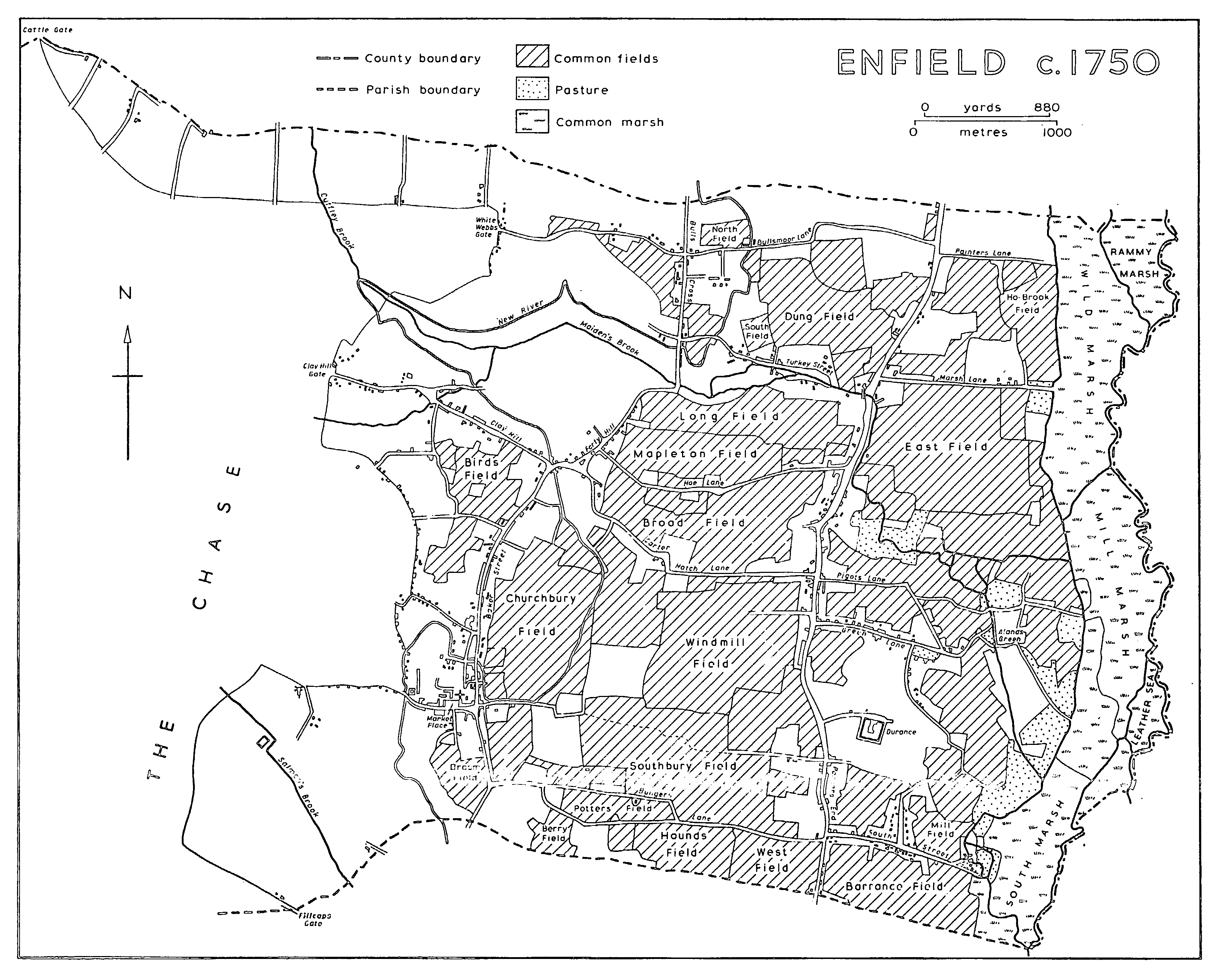
Ermine Street, mentioned in the reign of Edward 1, (fn. 1) apparently entered the parish south of Enfield Town and passed east of Forty Hill and Bull's Cross. (fn. 2) Together with the other main roads it formed a rough grid pattern of highways from London crossed by routes leading westward from the Lea. The main north-south route, later known as Hertford Road, may have been the high street of Enfield mentioned in 1260. (fn. 3) It bisected the land between the Chase and the Lea, running slightly west of the marshes along the river. The road was placed under the new Stamford Hill turnpike trust in 1713 (fn. 4) and taken over by the commissioners for the metropolitan turnpike roads in 1826. (fn. 5) A short realignment north of Enfield Highway had taken place by 1830, (fn. 6) the new stretch passing east of what was henceforth known as Old Road. Hertford Road crossed Maiden's brook by a ford at Enfield Wash, (fn. 7) where a footbridge existed by 1675. (fn. 8) In 1772 another wooden bridge was built by the turnpike trustees but in 1814 the state of both bridge and road was very bad (fn. 9) and in 1820 the bridge, which was intended to take carriages when the brook was in flood, fell down. (fn. 10) A new wooden footbridge was built by the county in 1821 (fn. 11) and a carriage bridge by the parish soon after 1827. (fn. 12)
A less important north-south route ran farther west, entering the parish at Bush Hill, passing east of Enfield church and market-place, and proceeding north-eastward over Forty Hill to Bull's Cross near the Hertfordshire boundary. It was called the highway from Bull's Cross to Enfield church in 1512 (fn. 13) but sections of the road later acquired separate names; south of Enfield Town it was London Road and from the town to Forty Hill it formed Silver Street and Baker Street, the latter name occurring in 1572. (fn. 14) North of Forty Hill the road dipped to cross Maiden's brook by Maiden's bridge, mentioned in 1572 (fn. 15) but impassable by 1759. (fn. 16) A new single-arched bridge was built in 1795 (fn. 17) and was repaired in the early 1970s. (fn. 18) A northern continuation of the road from Bull's Cross into Cheshunt was called Hillocks Lane in 1754 (fn. 19) but in 1972 was only a private drive to Theobalds Park. In the 18th century the Stamford Hill turnpike trust took over London Road as far north as Enfield Town. (fn. 20) The entrance to the town from the south was said to be very narrow and dangerous in 1823, when improvements were proposed. (fn. 21)
A third northerly route, through the western part of the parish, crossed the Chase from Cockfosters to Potters Bar. In 1656 it apparently ended abruptly a little beyond West Lodge (fn. 22) but its northward continuation was shown in 1777. (fn. 23) The southern stretch was known as Cockfosters Road and the northern part as Southgate Road in 1972.
Several roads ran from east to west on either side of Hertford Road. The southernmost, from the Lea to London Road, crossed Hertford Road at Ponders End and formed the main link between Ponders End and Enfield Town until c. 1800. (fn. 24) Its western section was known in 1572 (fn. 25) as Bungeys or Bungers Lane but by 1823 was more generally called Brick or Red Lane; it was said to have been nearly impassable in the later 18th century and in 1823 to have been a private road of William Mellish. (fn. 26) It was renamed Lincoln Road between 1868 and 1897. (fn. 27) South Street, the stretch east of Hertford Road, was mentioned in 1548. (fn. 28) In 1868 it ended by the mill later known as Wright's flour mill (fn. 29) but by 1897 it had been extended, as Valley Road, to cross the Lea at Ponders End lock. (fn. 30)
North of Bungeys Lane Farm Road ran westward from Ponders End and continued as a footpath to Enfield Town, until in 1803 it was extended west across Southbury field to the town as a public road. (fn. 31) It became known as Nags Head Road but by 1896 had been renamed Southbury Road, the name Nags Head Road being transferred to a new road running eastward from the junction of Southbury and Hertford roads toward the Lea. (fn. 32) Southbury Road was widened to take trams in 1909-10. (fn. 33) By 1972 Nags Head Road had been extended on a bridge over the Lea Navigation to meet Lea Valley Road, forming part of a major east-west arterial route.
Green Street, farther north, was so named in 1471. (fn. 34) At its eastern end it split into Stockingswater and Millmarsh lanes, both of which led to the Lea. Millmarsh Lane crossed the mill river by a bridge, mentioned in 1472, (fn. 35) which came to be identified with Raddington bridge, whose profits had been used by Baldwin Raddington, lord of the manor, to endow a charity in 1397. (fn. 36) The bridge was ruinous in 1655 (fn. 37) and after collapsing in 1801 (fn. 38) it was not rebuilt, the vestry having decided that it was the responsibility of the trustees of the Lea Navigation.
Carterhatch and Hoe lanes, north of Green Street, ran westward from Hertford Road to Forty Hill. One of them may have been the king's highway from Horsepool (Enfield Highway) to the Chase mentioned in 1366; (fn. 39) both were recorded in 1572. (fn. 40) Turkey Street, farther north, was recorded in 1427 (fn. 41) and ran from Enfield Wash to a point south of Bull's Cross. Its eastern part skirted Maiden's brook, which it crossed by a bridge near the site of Turkey Street railway station. A bridge existed in 1759 (fn. 42) and was replaced in 1791 by one of three arches, of brick and stone, which was repaired in 1809 but was said to be dilapidated in 1826. (fn. 43) A lane running eastward from Enfield Wash to the Lea was called Norris Lane in 1577, (fn. 44) Marsh Lane in 1754, (fn. 45) Welches Lane in 1823, (fn. 46) and Ordnance Road by 1897. (fn. 47) The building of the Royal Small Arms factory c. 1804 (fn. 48) led to an increase of traffic and in 1818 the Board of Ordnance unsuccessfully indicted the parish for failing to repair the road. (fn. 49) Part of the road was diverted in 1865. (fn. 50) The northernmost of the eastwest cross routes, Bullsmoor (or Belsmoor) and Painters lanes, were both recorded in 1572. (fn. 51) Painters Lane in 1972 was a path leading to the Lea.
ENFIELD c. 1750
The chief road running west from the route linking Bull's Cross to Enfield Town was that which led from the town to Enfield Chase. Later known as Church Street, it entered the Chase at Park Gate, which in 1658 stood slightly east of the bridge over the New River. (fn. 52) Thence in 1658 a track ran north alongside the modern Chase Green, its southernmost portion forming the path which came to be called Gentleman's Row. Having crossed the New River, it ran north-west across the Chase to the top of Holtwhite's Hill where it met Parsonage Lane, so called in 1572, (fn. 53) which later stopped at Chase Side. The western part of the road, with the other major roads through those parts of the Chase allotted to Enfield, was made public in 1803 (fn. 54) and renamed Holtwhite's Hill between 1868 and 1897. (fn. 55) Another road ran westward from Baker Street to join Holtwhite's Hill at the summit. The road was simply New Road in 1754 (fn. 56) but its western part had become Lavender Hill by 1868, presumably after the lavender formerly grown there; (fn. 57) the eastern part was called New Lane in 1867 and Lancaster Road by 1898. (fn. 58) Chase Side, running northward from Chase Green to New Lane (Lavender Hill), probably existed as Woodside in 1572 (fn. 59) and received its modern name after 1803. (fn. 60)
From the junction at the top of Holtwhite's Hill the Ridgeway ran north-west across the Chase in 1658. (fn. 61) Near the western boundary it joined the road running north from Cockfosters and as Camlet Way, mentioned in 1658 and named after an ancient site called Camlet Moat, (fn. 62) continued westward into Monken Hadley. The stretch of the Ridgeway east of Cockfosters Road had been renamed Hadley Road by 1803, at which date the Ridgeway itself continued north-westward to Potters Bar. (fn. 63) The Act of 1777 ordered that the Ridgeway be extended southeastward to Enfield Town (fn. 64) and in 1778 work was in progress. (fn. 65) A committee of the vestry reported in 1807 that the roads built under the inclosure Acts were unusable (fn. 66) and in the mid 19th century the Ridgeway was said to be a muddy track; (fn. 67) later, however, it became part of the busiest east-west route in the parish. At the top of Windmill Hill, so called in 1868, (fn. 68) the extended Ridgeway met a road running from Enfield to East Barnet, known as Merryhill Way in 1658 (fn. 69) and East Barnet Road in 1803. (fn. 70) From east to west it was called Slades Hill, Enfield Road, and Bramley Road in 1974.
From Forty Hill a road which ran westward was known as Bridge Street in 1572 (fn. 71) and Clay Hill Lane in 1754. (fn. 72) It crossed Maiden's brook by a bridge which needed repair in 1759 (fn. 73) and was rebuilt, with one arch, in 1803. (fn. 74) Beyond Clay Hill it continued north as Theobalds Park Road, first mentioned in 1803, (fn. 75) to the former park in Cheshunt (Herts.), (fn. 76) near whose boundary it met a road from Bull's Cross. In 1572 the eastern part of the road from Bull's Cross was called Rome Street and the rest White Webbs Lane, (fn. 77) a name later extended to the whole length. West of the junction with Theobalds Park Road, White Webbs Lane continued as Cattle Gate Lane to the boundary with Northaw (Herts.). Like East Lodge Lane, which ran south-westward to connect it with the Ridgeway near East Lodge, it was made into a public road at inclosure in 1803. (fn. 78) The most northerly of the east-west routes in Enfield, Coopers Lane, which followed the boundary from Cattle Gate to Potters Bar, also became a public way in 1803.
The most important addition to the early-19thcentury road-pattern was Great Cambridge Road, built in 1923-4 and widened in the 1960s. (fn. 79) It follows a straight line from south to north, bisecting the area between Hertford Road and the route through Enfield Town to Bull's Cross.
A coach called the Enfield Fly left Enfield for London on weekdays in 1783, returning in the afternoons, (fn. 80) and by 1791 coaches ran twice daily to Holborn, Bishopsgate Street, and Aldersgate Street. (fn. 81) In 1832 there were four coaches a day from Enfield Town to London, as well as coaches from Enfield Highway to Ware and Hertford. (fn. 82) Omnibuses served Forty Hill and Clay Hill in 1862 (fn. 83) and a horse tram service from Stamford Hill through Tottenham and Edmonton was extended to Ponders End in 1882. Horses were replaced by steam locomotives in 1885 but in 1891 horse traction was resumed. (fn. 84) In 1890 trams ran every quarter hour from Ponders End to Finsbury Park. (fn. 85) The service was electrified in 1905 and in 1908 was extended along Hertford Road to Waltham Cross (Herts.). In 1909 a service along London Road to Enfield Town was introduced and about two years later trams began running to the town along Southbury Road. From 1912 they ran through from Enfield Town to Tottenham Court Road and a year or so later from Ponders End, Enfield Highway, and Waltham Cross to Smithfield. (fn. 86) They were replaced by trolley-buses in 1938 and they in turn by motor-buses in 1961. (fn. 87)
The Northern and Eastern (later the Great Eastern) Railway opened its main line along the Lea valley in 1840 (fn. 88) and a station was built in South Street to serve Ponders End. (fn. 89) Ordnance Factory station in Ordnance Road was opened in 1855 and in 1886 was renamed Enfield Lock. (fn. 90) A third station, Brimsdown, was opened at the end of Green Street in 1884. (fn. 91) Services at first were infrequent and the distance of the stations from the largest centre of population, Enfield Town, prompted the promotion of a branch line from Water Lane, Edmonton (later Angel Road). An Act was passed in 1846 (fn. 92) and in 1849 the line was opened to a terminus in Nags Head Lane (near Southbury Road). (fn. 93) In 1859 there were ten trains a day in each direction, the journey from Enfield Town to London taking 45 minutes, while on the Cambridge main line ten trains called at Ponders End in each direction, of which four stopped additionally at Ordnance Factory station. (fn. 94) The service to Enfield Town greatly improved after the opening of a line from Bethnal Green to Lower Edmonton in 1872, although some trains continued to use the longer route via Angel Road until 1939. (fn. 95) The first Enfield Town station, a 17th-century house which had served as a private school, (fn. 96) was replaced in 1872. Workmen's trains ran from 1874, with a return fare to London of 2d., and in 1891 five left Enfield Town daily before 6.30 a.m. (fn. 97) By 1901 trains from Enfield Town to London were halfhourly, except at rush hours, and in 1920 a faster service was introduced. (fn. 98)
In 1891 the G.E.R. opened a new line through the parish from Lower Edmonton to Cheshunt, with stations in Southbury Road and Turkey Street, the second of which was called Forty Hill. (fn. 99) Trains ran to White Hart Lane (Tottenham), where passengers had to change. The expected suburban growth did not take place, partly because of the lack of through trains to London, and the line was closed to passengers in 1909 after the introduction of electric trams along Hertford Road. It was reopened from 1915 to 1919 for workers in local munitions factories, with an extra station in Carterhatch Lane, but thereafter until 1961 was used only by a daily freight train. When suburban services to Liverpool Street were electrified in 1961, however, the line was again opened with half-hourly electric trains to Bishops Stortford (Herts.) calling at the two older stations, which were renamed Southbury and Turkey Street. The branch to Enfield Town was also electrified in 1961, a new station was built, and the journey to London reduced to 29 minutes with trains leaving every 20 minutes except at rush hours. (fn. 100) Electric trains also ran along the main line through Ponders End at half-hourly intervals from 1970.
The Great Northern Railway built its main line north from London through the western part of the parish in 1850, but Enfield had no station when the line which later ran from King's Cross was opened from a temporary station in Maiden Lane in 1852. (fn. 101) In 1885, however, a station was opened in Camlet Way to serve the new Hadley Wood estate, with twelve trains a day to London. (fn. 102) In 1972 there was a half hourly service, with extra trains at rush hours. A branch from the main line at Wood Green through Enfield to rejoin the main line at Hertford was approved in 1865 but the line was not opened until 1871 and did not proceed farther north than the Enfield terminus in Windmill Hill. (fn. 103) In 1887 37 trains a day left Enfield for King's Cross, (fn. 104) while some ran to Broad Street and others until 1907 to Woolwich and Victoria. (fn. 105) The plan to extend the railway to Hertford was revived in 1897 and the line was opened in 1910 as far as Cuffley (Herts.), with new stations at Grange Park, Gordon Hill, and Crews Hill; the old terminus was turned into a goods depot and a new station (called Enfield Chase) was built to the east, at the foot of Windmill Hill. (fn. 106) The extension involved the building of a fourteen-arched brick viaduct, called Rendlesham viaduct, over the valley of Maiden's brook between Gordon Hill and Crews Hill stations. (fn. 107) Trains ran at half-hourly intervals and more frequently at rush hours in 1972, although for some time several of them terminated at Gordon Hill. (fn. 108)
The last railway to be built was the Cockfosters extension of London Transport's Piccadilly line, opened in 1933. (fn. 109) It penetrated only the southwestern corner of the old parish, where its terminus was constructed in Cockfosters Road. The station, an impressive building of reinforced concrete and glass by Charles Holden, (fn. 110) served as a railhead for motor-bus services to expanding suburban districts.