A History of the County of Middlesex: Volume 9, Hampstead, Paddington. Originally published by Victoria County History, London, 1989.
This free content was digitised by double rekeying. All rights reserved.
T F T Baker, Diane K Bolton, Patricia E C Croot, 'Hampstead: Hampstead Town', in A History of the County of Middlesex: Volume 9, Hampstead, Paddington, ed. C R Elrington( London, 1989), British History Online https://www.british-history.ac.uk/vch/middx/vol9/pp15-33 [accessed 27 July 2024].
T F T Baker, Diane K Bolton, Patricia E C Croot, 'Hampstead: Hampstead Town', in A History of the County of Middlesex: Volume 9, Hampstead, Paddington. Edited by C R Elrington( London, 1989), British History Online, accessed July 27, 2024, https://www.british-history.ac.uk/vch/middx/vol9/pp15-33.
T F T Baker, Diane K Bolton, Patricia E C Croot. "Hampstead: Hampstead Town". A History of the County of Middlesex: Volume 9, Hampstead, Paddington. Ed. C R Elrington(London, 1989), , British History Online. Web. 27 July 2024. https://www.british-history.ac.uk/vch/middx/vol9/pp15-33.
Hampstead town.
The earliest settled area was probably Hampstead town, on the southern slopes of the heath, near the manor and church and on each side of the road to Hendon, later called Hampstead High Street. The principal parish well, Kingswell, in the heart of the old town and probably associated with the town pond west of High Street, in which a woman drowned in 1274, (fn. 1) gave its name to the Kingswell family (fl. 1281-1319) whose freehold property lay between High Street and the demesne on the west. Nearby was the copyhold Slyes and Popes. (fn. 2) There was a group of medieval customary tenements in Pond Street, so named by 1484 (fn. 3) after another pond which was filled in in 1835 to form South End Green. (fn. 4) Four tenants were surnamed atte Pond on the earliest rental (1259) (fn. 5) and other medieval tenements, those of the Aldenhams and Bertrams, were in Pond Street. (fn. 6)
By the 15th century many of the customary tenements had passed to London merchants and gentry, (fn. 7) some of whom began to occupy or lease them, especially for the summer or in old age. (fn. 8) The country retreats in an area appreciated c. 1593 for its air and beautiful views (fn. 9) were especially favoured by the Londoners' wives, who often lived out their widowhood in houses originally acquired for the income from their rents. (fn. 10) Such people replaced the medieval houses of timber and wattle and daub with brick houses, often of considerable size. One was the curiously named Chicken House on the east side of High Street, which contained glass commemorating a visit by James I and the duke of Buckingham in 1619. Another house, perhaps of the early 17th century and with some classical features, stood on the west side of High Street, farther north. (fn. 11) Queen Elizabeth House, presumably nearby, was traditionally that monarch's hunting lodge but was later acknowledged to be of much more recent date. (fn. 12) The parsonage house on the east side of High Street opposite Church Lane, the site of the present no. 28, had apparently been built by 1660 (fn. 13) and was assessed for 7 hearths in 1674. (fn. 14) Nearby was a brick house which by 1660 had lately replaced three tenements and was assessed in 1664 for 10 hearths. It descended from William Pitchford (fn. 15) to his daughter, wife of Richard Hodilow, a London goldsmith (d. 1698). (fn. 16) Pitchford also owned Popes meadow, which passed to his second daughter Anne, wife of Isaac Honywood, (fn. 17) and became part of the Honywood, later Carlile, estate, which surrounded the Chicken House. (fn. 18) Carlile House had been built by 1692. (fn. 19) Two mansion houses were new-built on the east side in High Street in 1698. (fn. 20)
On the west side, stretching from Church Lane southward to the Belsize estate, was the medieval customary holding of Slyes. In addition to the capital messuage there was, by 1621 and probably earlier, another house, almost certainly that later called Vane House, if the well found during rebuilding after the Second World War was 16th-century. (fn. 21) Both were leased out by 1621. (fn. 22) In the mid 17th century, in addition to Slyes itself, there was, at the northern end of the estate, a house occupied by Thomas Hussey, a London grocer, which was assessed in 1664 for 14 hearths (fn. 23) and occupied in 1675 by William, Lord Paget (d. 1678); a second house had been 'recently' built south of it by 1675. (fn. 24) At the southern end of the estate there was one large house, that later called Vane House opposite the Chicken House. In 1664 the two largest houses in the parish, which were listed next to each other, were assessed to Lady Vane for 24 hearths and to Col. John Owen for 20 hearths. (fn. 25) Contemporary memoirs stated that Sir Henry Vane was arrested in 1660 at 'his house in Hampstead near London' (fn. 26) and local piety in 1795 identified it with that then called Vane House. (fn. 27) More probably, however, Owen occupied in 1664 the house which he certainly possessed in 1681, namely Vane House. (fn. 28) Vane's house, therefore, may well have been Slyes itself. By 1686 Slyes had become two houses, occupied by the copyholder William Johnson, a London herbalist, and by a tenant respectively. (fn. 29)
Many inns appeared in High Street during the 17th century. The King of Bohemia's Head, mentioned in 1680, (fn. 30) a mid-17th century building at no 14, on the east side, may have originated during the period of enthusiasm for Frederick V, count palatine, after 1619. (fn. 31) The White Lion on the east side was temporarily suppressed in 1641 but a 'very considerable new building' had been erected on the site by 1671. (fn. 32) The name did not occur after the 17th century and the inn may be identifiable with the King's Arms, so named from 1721, which probably dated from the 17th century and stood opposite Perrin's Court. (fn. 33) The King's Head, mentioned from 1721, later called the King William IV, on the west side at the junction with Church (Perrin's) Lane, is probably identifiable with the Queen's Head sited on the Kinghall estate and described as much decayed in 1667. It was extended and a bowling green added c. 1683. (fn. 34) On the east side the George existed south of the junction with Pond Street by 1666, (fn. 35) the White Hart by 1684, (fn. 36) and the Three Tuns by 1685. (fn. 37)
Building in High Street was on ancient, mainly customary, tenements which were divided and underset but probably did not stretch farther north than the junction with Heath Street, which in 1680 formed a broad green, over 100 ft. wide, extending from the heath. (fn. 38) Development northward and eastward was on the heath, technically waste although Hampstead manor court did not recognize wastehold tenure and land taken from the waste became copyhold, indistinguishable from the ancient customary tenure. (fn. 39) The heath was used for many purposes other than pasturing: Cloth Hill, for example, recalled laundering, and there were also diggers of gravel or brickearth and herbalists. (fn. 40) They enclosed usually small areas of heath and put up cottages and sheds in a haphazard way. The passages to such enclosures and the spaces between them became roads and squares which, with the steep and uneven nature of the ground, accounted for the bizarre street pattern of Hampstead town. Since roads were unpaved the distinction between them and the surrounding waste, especially on the fringes of settlement, was vague. The process was illustrated in 1762 in the routes round Squire's Mount, which was to become Cannon Place and Lane and Well Road. (fn. 41) Only after 1737 were all enclosures recorded, since early records were destroyed and many enclosures originated in squatting during periods of unrest.
One such encloser was Robert James (d. 1618). (fn. 42) In 1619 one of his daughters, Mary, wife of Robert Dixon, succeeded her brother Robert in the copyhold, (fn. 43) described in 1637 as seven cottages at the north end of the town at East End on the waste or heath. (fn. 44) East End or Ostend was the first name of Fenton House in Hampstead Grove, which is dated 1693. (fn. 45) There was a windmill nearby from the beginning of the century (fn. 46) and in 1666 Robert Dixon conveyed the seven cottages, with land called the Millhill, to a brickmaker. (fn. 47) Millhill near Ostend, where there were grants of waste in the 1680s, (fn. 48) was presumably Windmill Hill, named in 1709. (fn. 49)
In 1646 Robert James's other daughter, Susan Nutting, conveyed parcels of her close next the heath called Boad's, Boar's, or Board's Corner, east of Heath Street, to several men, mostly 'poor tilemakers', who in 1648 successfully petitioned to be allowed to erect cottages without the statutory 4 a. Most of them also received confirmation at the manor court for their cottages, six of which had been built in 1646. (fn. 50) There was a brick clamp nearby (fn. 51) and one at least of the petitioners, Thomas Roberts, seems to have prospered, leasing Donningtons as a brickmaker in 1655 (fn. 52) and acquiring more waste around his house in 1672. (fn. 53) By 1679 Roberts had two houses in what by then was called New End. (fn. 54) Most 17th-century building in New End was of cottages but there was a new brick house by 1694 when, with five cottages, it was owned by Fortune Mountague, widow; (fn. 55) another two cottages had been built on the estate by 1704. (fn. 56) The White Bear carries a panel dated 1704 (fn. 57) and the Duke of Hamilton's Head, though first named in 1721, probably originated as a cottage c. 1700. A shop was added c. 1718 and the conversion to an inn probably occurred soon afterwards. (fn. 58) In 1710 34 quit rents, mostly for dwellings, were paid for New End. (fn. 59)
Building on the waste between East End and New End proceeded during the 17th century. In 1662 Thomas Goulding, a blacksmith, was granted a cottage and forge which he had recently built, (fn. 60) presumably at Goulding's or Golden Yard, west of Heath Street. (fn. 61) Holly Hill House, in a hollow on the west side of Holly Hill, supposedly dated from 1665 (fn. 62) and cottages existed by 1669 'next to the well, under the place called Cloth Hill'. (fn. 63) Cloth Hill, where cottages and a carthouse were built in the 1680s, (fn. 64) appears to have stretched from Holly Hill to the high ground called the Mount, west of Heath Street, where two houses, later no. 6, were built in 1694. (fn. 65) The Crown was one of several houses there in the 1690s. (fn. 66)
The beginning of the growth of Hampstead town, whose pure air had been acknowledged from the 16th century and mineral waters since the mid 17th century, is traditionally dated to 1698 when the Wells charity was founded. (fn. 67) Commercial exploitation of the waters was well advanced by c. 1700 when both the Flask public houses existed, the fashionable Upper Flask (originally called the Upper Bowling Green House) at the northern part of Heath Street and the Lower Flask in Flask Walk near High Street. The expansion after the Long Room was opened was rapid. Well Walk with its social activities pushed settlement farther eastward, and inns, shops, and lodging houses sprang up throughout Hampstead town to cater for invalids taking the waters and for more active visitors. In 1724 Hampstead had grown 'from a little country village to a city', where the popularity of both the place and the diversions had 'raised the rate of lodgings and that increased buildings'. (fn. 68)
Among inns of the period were the Haunch of Venison, on the east side of High Street c. 1729-31 (fn. 69) and a coffee house in 1730, which became the Bird in Hand at no. 39, licensed from 1771. (fn. 70) Many houses were built in High Street in the early 18th century (nos. 25, 26, 36 on the east side, nos. 68-75, 79-85 on the west); the most important was the Green Hill, at the corner with Prince Arthur Road, (fn. 71) later called Stanfield House after the artist Clarkson Stanfield (1793-1867), who lived there from 1847 to 1865. (fn. 72) The houses on the west side of High Street were on the Slyes estate. The former capital messuage was converted into four tenements between 1712 and 1721. (fn. 73) When the estate was split in the 1750s, the southern portion of the messuage seems to have been rebuilt and extended as Mount Grove (the Rookery); the other tenements can probably be identified with Stanfield House and its neighbours. (fn. 74) Vane House, described as enchanting and elegant in 1751, (fn. 75) was embellished with 16th-century painted glass by Bishop Joseph Butler (1692-1752), the theologian, who lived there from 1749, and after his death was divided, his offices being made into a house occupied by Alderman George Nelson in 1762, when the owner Andrew Regnier occupied the main portion. (fn. 76) On the east side of High Street, Norway or Burford House had been built by 1754 when its occupier Thomas Osborne, a London bookseller, held a party there, followed by a duck-shoot on the heath and entertainment at the Long Room. The house stood back from High Street, (fn. 77) behind Flask Walk, where a terrace of shops, nos. 1-7, was built in the early 18th century and Thomas Gardnor built the house named after him c. 1736. (fn. 78) Nos. 22-4 Rosslyn Hill, on old customary land fronting the east side of the main street, half-way between the Chicken House and Pond Street, had been built by 1762 but probably not by 1702, the date displayed on plaques. The initials on one may refer to Zechariah Morrell, an early 18th-century minister of Rosslyn Hill chapel. (fn. 79)
There were c. 24 houses in Pond Street in the first decade of the 18th century, (fn. 80) including nos. 33-5 (fn. 81) and the 'large convenient house' which had lately been occupied by Alderman Sir Thomas Lane (d. 1708). (fn. 82) Lane had three houses in Pond Street, (fn. 83) probably identifiable with three existing in 1654, one on the site of the medieval Aldenhams, the others called the White House and the Lower White House; they passed to John Lane in 1673, (fn. 84) although he had held a lease of Aldenhams before that and had been assessed on 9 hearths. (fn. 85) Already containing several substantial houses in the 17th century, Pond Street gained in importance from the wells, as it was the route by which early carriage visitors reached Well Walk, to the disgust of traders in High Street. In 1745 Pond Street was depicted as spacious and elegant, containing most of the houses existing in 1762 on the north side; they included nos. 17 and 17A, (fn. 86) probably the 'handsome new house' built by Edward Snoxell on the site of an ancient one soon after 1740. (fn. 87) In what was later Rosslyn Hill, south of the junction with Pond Street, a second house stood by the 1740s north of the ancient Bartrams, set back from the main road and approached through a grove railed in from the waste. (fn. 88) Two houses were built on the waste near the George by 1756 (fn. 89) and another two by 1758. (fn. 90)
Two houses in Heath Street (nos. 92 and 94) were built c. 1700 and two (nos. 60 and 62) in the early 18th century. (fn. 91) A house was built on the site later occupied by Guyon House (no. 98) probably between 1722 and 1740 by William Knight. (fn. 92) On the western side of the road Caroline House and Holly Cottage (nos. 11 and 12 the Mount) were built in the mid 18th century. (fn. 93) East of Heath Street, growth proceeded at New End, nos. 10-14 being a terrace of 1725 and, in the southward extension from the original road, no. 30 being early 18th-century; (fn. 94) nearby was the Fox and Goose, recorded in 1726. (fn. 95) In New End Square (in fact a triangle) the most important building was Burgh House, named after a 19th-century owner and earlier called Brook House, built in 1703 by Henry and Hannah Sewell, wealthy Quakers, and greatly extended after 1720 by Dr. William Gibbon, physician to Hampstead wells. From 1743 it was occupied by Nathaniel Booth, later Lord Delamer (d. 1770). (fn. 96) On the western side of New End Square nos. 16-20 were built in the early 18th century. (fn. 97) At no. 40, the southern corner with Flask Walk, the Hawk had been built by 1748. (fn. 98)
Elm Row, the next street northward off the east side of Heath Street, was presumably called after the line of trees there in 1762. (fn. 99) On the north side a terrace was built c. 1720 (fn. 100) and on the south Elm Lodge, variously ascribed to c. 1700 and c. 1732, faced southward to New End. (fn. 101) At the eastern end of Elm Row was Hampstead Square, described in 1725 as having been, 60 years previously, a 'high hill and a sandpit so that there could not be any way through'. (fn. 102) Lawn House (no. 12) was built at the Elm Row end and Vine House (no. 6), a five-bayed house at the northern corner, probably before 1709; (fn. 103) no. 1, also of five bays, adjoined the northern terrace of Elm Row and was probably built c. 1720, (fn. 104) as was the neighbouring no. 2. Opposite Vine House nos. 7-9 (in 1986 Newman Hall homes for the aged) were built c. 1730. (fn. 105) Eastward from Hampstead Square, Cannon Place led to Squire's Mount, named after Joshua Squire (d. 1717), a London factor, who acquired waste near an old well in 1714 and built a residence there. (fn. 106) Squire was succeeded by his two daughters, one of whom married Thomas Lane (d. 1773), master of Chancery. By 1750 two other houses had been added with Lord Blessington as the tenant. (fn. 107) In 1762 Lane occupied the largest, northern house. (fn. 108) The two southern houses were later reunited as Chestnut Lodge. (fn. 109) Since a terrace of cottages, nos. 1-5 bearing a plate 'Squires Mount Croft 1704', did not exist in 1762, the plate may have come from the stabling of Squire's Mount. (fn. 110) Cannon Hall (no. 14 Cannon Place), named from cannons brought by Sir James Cosmo Melville, who occupied it after 1838, was built c. 1720 and originally called Rous's Buildings, probably after Joseph Rous, who succeeded John Duffield as lessee of the Wells estate. (fn. 111) The name Cannon Hall probably referred to the whole estate, which extended to Well Road and Christchurch Hill and in 1762 included three other houses, the early 18th-century Providence Corner (formerly Holly Hedge Cottage) and Cannon Cottage (fn. 112) and the later Cannon Lodge (no. 12 Cannon Place), then two houses. (fn. 113) In 1762 Cannon Hall was occupied by Sarah Holford, widow, who had leased it from 1752 and probably from before 1745 when a print of the Long Room 'from Mrs. Holford's garden' was published. The family later gave its name to Holford Road, a wide, tree-covered piece of waste in 1762. (fn. 114) To the north, on the edge of the heath, lay no. 22 East Heath Road (Grove House, later Holford or Heathfield House, Melville Hall, and finally Ladywell Court), in 1762 a 'capital messuage' with stabling, a greenhouse, and 1½ a. owned and occupied by Thomas Webb. (fn. 115) In 1762 the most northerly dwelling set back from the east side of Heath Street, was a pair of houses opposite Whitestone pond, (fn. 116) which existed by the mid 1740s (fn. 117) and were probably the early 18th-century Gangmoor. (fn. 118)
The eastern extremity of the town was on the Wells charity estate on either side of Well Walk, where 100 trees had been planted by 1700 (fn. 119) and there were two houses, a dancing room, shops, and stables by 1704. (fn. 120) The dancing room was presumably the Great Room or first Long Room, on the south side, and Wells House was built next to it probably before 1722 for gambling. (fn. 121) Although the wells had lost their fashionable cachet by 1725, when Joseph Rous converted the first Long Room to a chapel, building continued and by 1734, when Alexander Pope visited them, a second Long Room had been built on the north side of Well Walk, outside the Wells charity estate. (fn. 122) By 1762 there were three houses, a cottage, Wells House, the chapel, the Green Man, and various outbuildings on the estate, (fn. 123) and two large buildings west of it, the second Long Room and a ballroom. (fn. 124) A single house, later called the Pryors, stood on the heath east of the Wells estate by the 1740s. (fn. 125)
The wells also influenced building on the west side of Heath Street. Most of the 17th-century building at Cloth Hill had been of cottages but in the early 18th century many were replaced by larger houses or stabling. (fn. 126) Residents included Anne, Lady Crew, later countess of Torrington (d. 1719). (fn. 127) Some handsome houses joined Fenton House at East End in the wooded area of the heath, appropriately called the Grove. Two were in the part called, after 1949, Admiral's Walk. One was built in 1700 by Charles Keys (d. 1753), a vintner, who called it Golden Spikes, probably after the symbol of the masonic lodge which met there between 1730 and 1745. Later called the Grove by Fountain North, a naval captain who lived there from c. 1775 to 1811, it was confused in prints with the residence of Admiral Matthew Barton (d. 1795), who lived elsewhere in Hampstead, and given the misleading name Admiral's House. Grove Lodge was built next to it at about the same time. (fn. 128) On the eastern side of the part called, after 1937, Hampstead Grove, were the earlier 18th-century Old Grove House (no. 26), with a wing added c. 1730 and, adjoining it to the north by 1762, New Grove House (fn. 129) (no. 28), supposedly on the site of one of the windmills. (fn. 130) Mount Vernon House, originally called Windmill Hill House, was built on the site of the other windmill between 1725 and 1728 by William Knight, a Hampstead timbersmith. (fn. 131) A terrace of tall houses was built at Windmill Hill c. 1730, later called Windmill Hill House (not the original house of that name), Bolton House, and Volta House, which in 1923 retained original panelling and 'hair-powdering closets'. (fn. 132) Enfield House, joining the terrace to the east, did not exist in 1762. (fn. 133) A terrace of houses built c. 1740 on the edge of the heath gave its name to Upper Terrace House, an 18th-century mansion, by 1762. (fn. 134) Capo di Monte, where Sarah Siddons lived in 1804-5, was one of three houses standing by 1762 at the corner of Upper Terrace and Judges Walk. (fn. 135)
The area west of High Street, made up of ancient copyhold and freehold, began to be built over in the early 18th century. Richard Hughes of Holborn was buying land on the west side of 'the great street of Hampstead' in 1710. (fn. 136) He began building on the Kinghall estate, where a bowling green had replaced the orchard, probably in the 17th century, before he acquired the freehold in 1713. One house may have been built by 1707 and by 1713 Hughes had built eight on the south side of what by 1728 was called Church Row, apparently all at one time (fn. 137) and as a speculation stimulated by the success of the wells. As freehold they were omitted from the survey of 1762, when the north side of Church Row had ten houses of various dates from the early 18th century. (fn. 138) Hughes probably also built at least 13 houses on the eastern extension of Kinghall, tenanted in 1730 mostly by tradesmen, including John Perrin, chandler, who may have given his name to Perrin's Court in the centre of the area, although, as freehold, it too was ignored in 1762. (fn. 139) North of Church Row the Yorkshire Grey had been built by 1723 (fn. 140) and cottages called Evans Row probably faced it c. 1730. (fn. 141) In 1757 the inn and 14 houses occupied by a brickmaker, clockmaker, carpenter, apothecary, and others were 'late freehold' (fn. 142) but in 1762 they were described as copyhold (one alehouse, two houses, and 11 cottages). (fn. 143) To the east, by 1762, was a crowded area of courtyards and alleys built on the customary tenement of Popes and possibly, in its northern reaches, on the wide green that had formed an extension of the heath in 1680. (fn. 144) The alley later called Oriel Court after Oriel House (itself not yet built) existed, (fn. 145) as did Bradley's Buildings, then called Bradley Row, possibly after William Bradley, who had interests in property there in 1762. (fn. 146) There were two large houses, Windmill Hill (later Mount Vernon) House and another, traditionally the farmhouse of the windmill, on the site later occupied by nos. 15-19 Holly Hill, at Windmill Hill (fn. 147) and between it and Oriel Court, (fn. 148) there were 27 houses, two carpenters', a smith's, and two butchers' shops, a brewhouse, and the Still (licensed in 1751), (fn. 149) the Cock (1730), (fn. 150) and the Three Horseshoes (1721), (fn. 151) besides two coach houses, ten stables, summerhouses, and hogstyes on less than 4 a. On the western side of High Street, south of Church Lane, (fn. 152) there were ten houses, a carpenter's shop and a smithy, the King's Head, (fn. 153) three coach houses, and several stables and cowhouses on nearly 12 a. Several mansions, including Vane House (then divided into two) (fn. 154) and Slyes, (fn. 155) kept that part of Hampstead town relatively spacious.
On the east side of High Street in 1762, there were five houses and the George south of Pond Street. (fn. 156) In Pond Street (fn. 157) there were 34 houses, 5 cottages, a butcher's shop, the White Horse (1721), (fn. 158) four coach houses, two chaisehouses, and numerous stables. In High Street, between Pond Street and Flask Walk, (fn. 159) there were 38 houses, 4 cottages, a butcher's and 2 other shops, a school, a meeting house, 3 public houses (the Three Tuns, the White Hart, the King's Arms), and numerous stables and coach houses, especially in and around Flask Walk. Between Flask Walk and Streatley Place (then called Brewers Alley) (fn. 160) there were 24 houses, 2 cottages, 5 shops including a smith's, cooper's, carpenter's, and tallow chandler's, the Lower Flask, (fn. 161) a coach house, a chaisehouse, and 2 stables, forming a more working-class area. It included the parish pond, (fn. 162) which had presumably replaced that in High Street c. 1700. There was no sign of the bowling green which had been part of the Lower Flask's attractions in 1705. (fn. 163) There were few buildings on the north side of Streatley Place but they were densely packed at Boad's Corner, both at the eastern end of the road, where there were 7 houses and 4 sheds on 14 perches, (fn. 164) and along the southern side of the road, later itself confusedly called New End, from Heath Street to New End. In the whole quarter, described as from Brewers Alley to Scarrotts Corner (probably the corner of Heath Street and New End) and New End, (fn. 165) there were 28 houses, one of them a 'capital house' with a coach house and large garden, 2 cottages, 3 shops including a plumber's and a cooper's, 3 stables, the Sun (1756), (fn. 166) and the Fox. (fn. 167) In New End quarter, comprising the southward extension of the modern New End and New End Square, (fn. 168) there were 6 houses, including Burgh House, 4 cottages, 4 coach houses, 2 stables, a workshop, the Hawk, and the (White) Bear. (fn. 169) To the east lay the Hampstead wells quarter, consisting of 5 houses, a cottage, a coach house, 4 stables, the Green Man, the Long Room, a drinking room, the chapel, and Wells House. (fn. 170) In the area north of the road called New End, stretching north of what later became East Heath Road, (fn. 171) there were 34 houses, 2 cottages, a workshop, 6 coach houses, 6 stables, and the Duke of Hamilton. Except in the square bounded by Heath Street, Elm Row, and Hampstead Square, where buildings were crowded together, it was a spacious area of quite large houses on the edge of the heath.
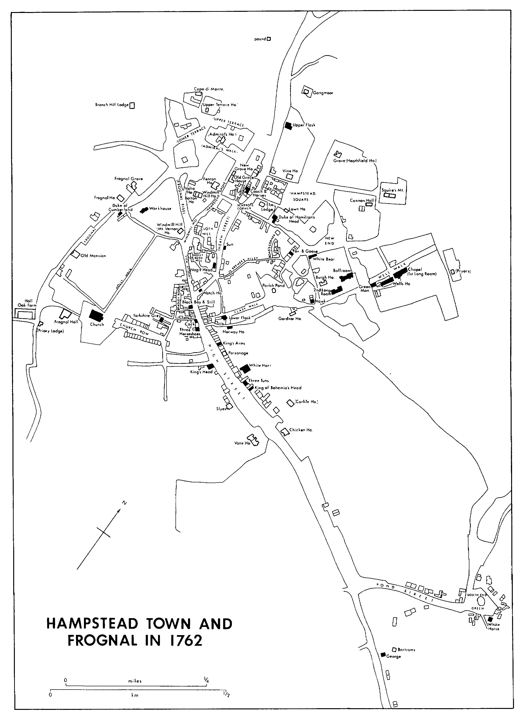
HAMPSTEAD TOWN AND FROGNAL IN 1762
On the west side of Heath Street, in the tongue of land bounded on the west by Holly Hill and Hampstead Grove, (fn. 172) buildings were mostly concentrated at the southern end and around The Mount Square. There were 54 houses, 3 cottages, 2 coach houses, 10 stables, the Coach and Horses, the Nag's Head, 7 shops including 2 smiths', a baker's, and a butcher's, and several sheds, one for a brickmaker. West of Hampstead Grove as far as Fognal Rise (then called the road to Childs Hill) and stretching northward to Judges Walk and Upper Terrace (fn. 173) were 21 houses, a cottage, 4 coach houses, and 8 stables. Like the area on the opposite side of Heath Street, it was a neighbourhood of large houses and gardens.
In all, Hampstead town contained c. 327 houses, 35 cottages, 20 shops, and 19 public houses in 1762. (fn. 174)
The later 18th century saw a decline in the wells and consequently the closure of some inns, although Hampstead's attractions as a permanent residence increased. By 1810 there were more than 500 dwellings in Hampstead town, (fn. 175) many of them fine new houses. Among High Street inns which closed were the Haunch of Venison after 1731, the White Hart probably by 1762, the King's Arms between 1770 and 1800, and the Three Tuns between 1773 and 1800. (fn. 176) Houses built possibly on their sites were nos. 27, 30-1, 45-6 High Street, all on the eastern side. (fn. 177) The Chicken House had become a lodging house by 1754 when Samuel Gale, the antiquary, died there (fn. 178) and after being licensed in the 1760s and 1770s as a public house acquired a dubious reputation. (fn. 179) In Pond Street nos. 17-21 were probably built in the late 18th century. (fn. 180) The street housed the Venetian ambassador in 1774, several fashionable doctors later, and Baron John Dimsdale from c. 1807 to 1815. An attempt to exploit a new spa in 1803 was a failure. (fn. 181)
Several substantial houses were built on the broad piece of waste south of Pond Street, later called Hampstead Green. By 1800 there were two brick houses in place of the old Bartrams. Between 1799 and 1814 most of the land and houses nearby was bought by Charles Cartwright, who between 1806 and 1809 replaced the relatively new capital messuage with the large, irregularly shaped house called Bartrams, behind the George. (fn. 182) In 1815 the lord of the manor agreed that Cartwright should let part of Lower Bartrams to his cousin William Winfield to build himself a 'substantial house' there, Belle Vue or Bartram Park, south of the existing 18th-century Belle Vue houses. In 1825 the George and most of Bartrams estate passed to trustees for Winfield. John Moore, a captain in the East India service, who lived in the northernmost of the Belle Vue houses, acquired the house and former waste north of the George which Cartwright had bought in 1799. (fn. 183) Although not on Bartrams copyhold, the house was usually called Bartram House. (fn. 184)
On the west side of High Street, Vane House was still divided in two in 1787, when it was sold to James Pilgrim (d. 1813). (fn. 185) Pilgrim modernized it, possibly in 1789, a date inscribed with the unidentified initials IRW on the leads, reorienting the main house and giving it a classical façade and portico. (fn. 186) It has been suggested that Admiral Matthew Barton lived there in the 1790s. (fn. 187) Farther north, there were 16 houses by 1767 on the freehold around Perrin's Court, (fn. 188) probably including nos. 74-6 High Street. (fn. 189) On the adjoining copyhold to the north was property acquired in 1757 and 1761 by George Bussee, a carpenter, (fn. 190) who in 1762 possessed one house on the north side of Church Row, which he occupied himself, (fn. 191) and four houses east of Little Church Row. (fn. 192) By his death in 1792 he had three houses, one of them probably Oriel House, which faced Church Row, and nine cottages in Crockett's Court. (fn. 193) In 1791 land adjoining the house on the eastern corner of Perrin's (then Church) Lane was offered as suitable for erecting a row of small houses (fn. 194) and nos. 14-26, at the western end, were built in the early 19th century. (fn. 195) Still farther north, at the southern corner of the lane to Bradley's Buildings, an old, possibly 16th-century, house was ruinous by 1777 and had been replaced by new houses by 1814. (fn. 196) Church Row housed the writers Anna Letitia Barbauld (1743-1825) and her niece Lucy Aikin (1781-1864) at no. 8 c. 1800 and Hampstead's historian John James Park (d. 1833) and his father Thomas (1759-1834), the antiquary, at no. 18 c. 1814. (fn. 197)
Some houses and cottages were built in the later 18th century in Holly Mount and in Holly Bush Hill, where Romney's House originated as the stables of no. 6 the Mount or Cloth Hill, which the artist George Romney (1734-1802) bought in 1796. Before he left Hampstead in 1799, he converted the stables into a house (Prospect House) and studio. His son sold the house in 1801, whereupon it was converted into assembly rooms and its stables into the Holly Bush tavern. (fn. 198) Bentham House, next to no. 6 the Mount, nos. 12 and 14 Holly Hill (Granary House), and no. 1 Holly Bush Hill (Alpine Cottage) were all built about the same time. (fn. 199)
In Heath Street the Sun closed in the late 1760s (fn. 200) and the Upper Flask became a private house in the 1750s, the home from 1769 of George Steevens (1736-1800), the commentator on Shakespeare. (fn. 201) Building on the west side of Heath Street included nos. 113-25 (odd), a 'pretty informal group of twostoreyed Georgian cottages', (fn. 202) which may have existed in 1762 as 'four messuages with a workshop', (fn. 203) no. 93 (Conduit House), late 18th-century, and nos. 83-89 (odd), early 19th-century. (fn. 204) On the east side nos. 112 and 114 may have existed in 1762; (fn. 205) no. 96 and no. 98 (Guyon House), the latter a large house named after a prominent Hampstead family, are late 18th-century; nos. 70-84 (even) and no. 118 (Mansfield Cottage) are of the same or slightly later date. (fn. 206)
In the area west of Heath Street, Netley Cottage (no. 10 Lower Terrace) was built by 1779; of nos. 1-4, forming an irregular range, nos. 1 and 4 may have existed in 1762. (fn. 207) Nos. 10-16 The Mount Square were built on the site of stabling and nos. 4-14 Hampstead Grove on the site of a 'walled ground with temple', all in 1762 part of Amy Cary's Old Grove House estate. (fn. 208) Amy Cary (d. 1769) was the widow of a London merchant and one of her neighbours was Lady Riddell. (fn. 209) Other local residents included the Holfords, a merchant family: Josiah (d. 1817) lived in 1775 at Windmill Hill House, before moving in 1776 to no. 22 Church Row and in 1782 to Holly Hill House, and Charles (d. 1838) at Upper Terrace House from 1799 to 1830. (fn. 210) Fenton House was bought in 1793 by Philip Fenton (d. 1807), a Riga merchant, whose son James was probably responsible for its Regency alterations inside. (fn. 211) Admiral's House was altered by Fountain North, whose additions included bulwarks, port-holes, and other features of a man-of-war, and who in 1805 bought and demolished the Grove for incorporation into his garden. (fn. 212) The neighbouring house to the west, Grove Lodge, (fn. 213) where priest's vestments were discovered, (fn. 214) may be identifiable with Grove House, 'on an eminence on the verge' of the heath, which was the residence of a French refugee, the marquis de Villedeuil, in 1792. (fn. 215) From c. 1781 to c. 1800 Gen. Charles Vernon leased Windmill Hill House, later called Mount Vernon, (fn. 216) previously the home of the surgeon William Peirce (d. 1772). (fn. 217) The author Joanna Baillie (1762-1851) lived from 1791 at Bolton House, where she was visited by leading literary figures. (fn. 218) John Constable (1776-1837), who painted Admiral's House, lived at no. 2 Lower Terrace from 1821 until 1823, when he moved to Stamford Lodge on the eastern side of Heath Street. (fn. 219)
Constable's first home in Hampstead, which he rented in 1819, was Albion Cottage, one of a group east of Heath Street, opposite Whitestone pond. (fn. 220) Fronting what was later called Whitestone Lane was the early 18th-century Gangmoor, which in 1762 formed two houses. Adjoining it was a Regency house called successively Heath House, the Lawn, and Whitestone House. (fn. 221) To the south fronting East Heath Road were, by 1829, several smaller houses, including Albion Cottage and Bellmoor, where Sir John Jackson, director of the East India Co., died in 1820. (fn. 222)
East Heath Road, which defined the limits of the heath to the north-east, did not exist in 1762 but two cottages (nos. 14 and 15), traditionally used by shepherds, were built at the north-west end in 1770. (fn. 223) Foley House at the junction with Well Walk, although locally reputed to be late 17th-century, was built after 1762. (fn. 224) It may be identifiable with three houses built between 1771 and 1773 by Edward Helling, a Holborn glazier, on a site described as bounded east and north by the heath, south by Upper Wells Walk, and west by the Cross Walk. (fn. 225) In 1786 Henry White, a local builder, had recently built East Heath Lodge and South Heath as a pair at the junction of East Heath Road and Heathside, then located as at Pollard Hill near the brick clamps. (fn. 226) Two smaller houses to the west, called Heathside, were added probably by 1814. (fn. 227)
A lane belonging in 1762 to Honywood (fn. 228) started as a broad tract from the junction of Flask and Well walks opposite the Long Room and ran to join a track along the line of East Heath Road. Besides being a farm lane it was probably used by visitors taking the air on the heath. (fn. 229) In the 1740s it was shown, perhaps inaccurately, as running farther north than in the 19th century. (fn. 230) The road, called Willow Road after willows planted there in 1845, (fn. 231) was by 1785 a public road from the bottom of Pond Street across the heath towards the Long Room. (fn. 232) In 1786 Henry White was permitted to make an open coach road across the heath southward from his new houses at Heathside to Willow Road. (fn. 233) His road was presumably part of that later known as East Heath Road. By 1814 a few houses had been built at the northern end of Willow Road. (fn. 234) The north-west part of Christchurch Hill in the mid 18th century formed a broad space between enclosures (fn. 235) and the south-east extension to Willow Road, earlier called Green Man Lane, existed by 1800; (fn. 236) no. 14 was 'late Georgian', (fn. 237) no. 26 (Sunnybank) early 19thcentury, (fn. 238) and there was a building, perhaps Willow Place, at the south-east end by 1814. (fn. 239)
In the old established area east of Heath Street, the Fox and Goose closed after 1773, (fn. 240) the Hawk became a private house between 1770 and 1800, (fn. 241) and the second Long Room (later called Weatherall House) had become one by c. 1803, when it was leased by Thomas Weatherall, a Cheapside haberdasher, to a linendraper from Fleet Street. (fn. 242) Nos. 36-40 (even) Well Walk were built on the site of Wells House in the early 19th century. (fn. 243) The Lower Flask, never so fashionable as the Upper Flask, survived in an area which became yet more workingclass. In the early 19th century workers' cottages (nos. 35-47, odd) were built in Flask Walk, with no. 48 opposite and some shops (nos. 2 and 4); Thomas Gardnor built the terrace, nos. 53-67 (odd) on the site of the parish pond in 1811 and no. 75 (Rose Mount) was built in 1812. (fn. 244) In 1800, when a workhouse was opened on the south side of New End, the site was 'like the bottom of a punch bowl . . . being every way surrounded by houses and very closely too, all above one another'. (fn. 245) To the south off Brewhouse Lane, Hitchman's Buildings were built c. 1814. (fn. 246)
In the late 18th and early 19th century Sir Thomas Maryon Wilson (d. 1821) and his mother Dame Jane (d. 1816) encouraged building on copyhold land by waiving their right to arbitrary fines on every death and alienation in favour of fixed fines for a specified term. In 1811 they made such an agreement with Thomas Gardnor, who had built small houses, Gardnor's Place, by 1815, on garden ground off Flask Walk. (fn. 247) A larger development took place to the east, with the effect of extending the limits of Hampstead town.
In 1811 the vestry bought the 2½-a. field on the east side of Holly Walk for a churchyard, which it made from only the southern portion. (fn. 248) It sold the rest which became the site of Prospect Place, stuccoed, weatherboarded, semi-detached houses traditionally built by French refugees, of Benham's Place, nine terraced cottages built in 1813 by William Benham, a High Street grocer, (fn. 249) and of Holly Place, a recessed terrace built in 1816 with the Roman Catholic chapel of St. Mary in the centre. (fn. 250) The Roman Catholic connexion went back at least to 1796, when the Abbé Morel first held services in Oriel House. (fn. 251)
The largest development in the early 19th century was on copyhold land east of the London road, between Pond Street and the built up area around Flask Walk. (fn. 252) In 1809 Samuel Gambier acquired most of the medieval estates called Searsfield, which since the 16th century had been linked with Bartrams, and Popes, which had been held by the Honywood family since the 17th century. In 1811 he conveyed 14 a. forming a compact block stretching from the London road to East Heath Road and South End Road, to William Coleman, a Kentish developer. (fn. 253) In 1812 Coleman agreed to pay the lord of the manor a fine based on a fixed rate per acre in lieu of the traditional two years' value. Coleman wanted to let on building leases (fn. 254) and, having mortgaged the original 14 a., obtained from Gambier the rest of the Honywood estate, another 15 a. adjoining it on the north, together with the mansion and meeting house. (fn. 255) By 1813 the western part of Downshire Hill and Keats Grove, originally called Albion Grove and then John Street, had been driven eastward from the London road to East Heath Road and at least some of the land divided into building plots, several subleased to William Woods. (fn. 256) Coleman had not paid for his latest acquisition by 1814, when Gambier's widow was in immediate need, and he sold the Honywood house and some 4 a. to Edward Carlile, who acquired another 9 a. in 1816 after Coleman's bankruptcy. (fn. 257) Building proceeded on Coleman's remaining estate. By 1814 there were a few houses at the eastern end, the most desirable because of its views over the heath. (fn. 258)
In 1815-16 the antiquary Charles Wentworth Dilke (1789-1864) and a retired St. Petersburg merchant Charles Armitage Brown (1786-1842) built for themselves a semi-detached pair called Wentworth Place (later Lawn Cottage, Lawn Bank, and finally Keats House). John Keats lived in Brown's house from 1818 to 1820, where he wrote much of his best work and met Fanny Brawn, whose mother was the tenant of Dilke's house. (fn. 259) After Coleman's bankruptcy, his interest was conveyed in 1817 to William Woods, who designed and built the church and probably most of the houses on the estate. In 1818 Keats wrote of the 'half-built houses opposite'. (fn. 260) Downshire Hill had probably been extended to Willow Road by 1819, when the Freemasons' Arms was built at the junction between them. By 1826 building was apparently complete on the northern side, where there were 18 houses between the public house and the junction with John Street; on the southern side were St. John's church, opened in 1823 in the angle with John Street, and at least five houses (nos. 39-43). Houses had also been built fronting East Heath Road at the end of John Street (Albion Grove House and a baker's shop) and off the London road (Sydney House). (fn. 261) Building was complete on all frontages by 1829, (fn. 262) many of the later houses being the work of William Kerrison. (fn. 263) An early inhabitant was John Constable, who moved from Heath Street in 1826 to no. 2 Langham Place, Downshire Hill, 'almost opposite the new church'. In 1827 he moved again, to no. 40 Well Walk, where he remained until his death. (fn. 264)
The exploitation of copyhold lands for building was in abeyance during the lordship (1821-69) of Sir Thomas Maryon Wilson, who could make agreements only of less than 21 years. (fn. 265) Activity was therefore small-scale, largely rebuilding or infilling. New Grove House was 'stuccoed and Tudorized' c. 1840 (fn. 266) and nos. 16-24 Holly Hill replaced a stable and garden between 1846 and 1850. (fn. 267) In Heath Street nos. 69-73 and 77-81 (odd) on the west side and Claremont Terrace (nos. 86-90 even) on the east were built in the mid 19th century. (fn. 268) A terrace called Willow Cottages (nos. 33-41 Willow Road) was built between 1852 and 1862. (fn. 269) One large house was the Logs (nos. 17-20 Well Road), built in 1868 to the design of J. S. Nightingale in yellow, red, and black brick, later described as 'a formidable atrocity' (fn. 270) and a 'wonderful uncertainty between Gothic and Italian'. (fn. 271)
Three cottages were built in New End Green (1848), three houses in Church Lane (1851), two in Perrin's Place (1846), and single houses in Lower Terrace (1846), Upper Terrace (1847 by Hugh Jackson), Flask Walk (1847 and 1851), on the charity estate in Well Walk (1850), Golden Yard (1851), and Willow Place (1852). (fn. 272) Building did not keep pace with demand, however, and the mid 19th century saw social decline. The working classes were said in 1848 (fn. 273) to be living in alleys and courts (fn. 274) without drainage or water supply. Overcrowding, with many families living in single rooms, was general and rents were high. There were several lodging houses and many of the former residences, including the Chicken House, Oriel House, Vine House, and South End House, were tenemented. (fn. 275) In 1848 the inhabitants of the Frognal demesne houses met at the home of Robert Prance to establish a branch of the Metropolitan Association for Improving the Dwellings of the Industrial Classes. In spite of basing their appeal for funds on fear of the contemporary European revolutions, (fn. 276) nothing apparently resulted. It was not until 1857 that Hampstead acquired a block of model dwellings, New Buildings or Court, built north of Flask Walk by the Jackson brothers, lawyers, of Upper Terrace; a reading room and ten more dwellings were added in 1871. (fn. 277)
Philanthropy helped to produce not only the model dwellings but several other institutions in the town. One of the largest buildings was the workhouse, rebuilt in 1847 and later considerably extended. (fn. 278) The dispensary, also in New End, opened in 1853, (fn. 279) Christ Church school opened in 1855 and the main buildings of Hampstead Parochial school west of Bradley's Buildings were built between 1856 and 1862. (fn. 280) The Royal Soldiers' Daughters' Home moved from one of the Belsize houses to part of Vane House in 1855 and a large purpose-built home on the southern part of Slyes estate in 1858. (fn. 281) The Royal Sailors' Daughters' Home, which had similarly grown out of the Crimean War, moved from Frognal to a new building, later called Monro House, designed by Edward Ellis in 1869 at no. 116 Fitzjohn's Avenue on the freehold Kinghall estate. (fn. 282) Several of the older residences were taken over by institutions. No. 28 Church Row housed a Roman Catholic school in the 1850s, a home for the rescue of young women in the 1860s, and a female servants' home in the 1870s. (fn. 283) Burgh House was from 1858 to 1881 the headquarters of the Royal East Middlesex Militia, which also built a barracks in Willow Road in 1863. In 1862 the Hampstead Volunteers took over Well Walk chapel, the Anglicans having departed in 1852 for Christ Church, built on what had been part of Hampstead Square. (fn. 284) Many early chapels were built in the town, partly because wealthy Roman Catholics and nonconformists provided sites and partly because only Anglican places of worship were permitted on the newly built Chalcots (Eton College) and Belsize (Westminster abbey) estates. (fn. 285)
A group of 'good Georgian houses' (fn. 286) south of the junction of the London road (Rosslyn Hill) with Pond Street included one occupied by Basil George Woodd in 1835 and another, Tensleys, the home of the historian Sir Francis Palgrave (1788-1861) from 1834 and of the architect S. S. Teulon from 1864 to 1868. Palgrave's son Francis Turner (1824-97), the poet, referred to the 'pretty, old-fashioned house at Hampstead'. (fn. 287) The next house to the south, Bartram House or Upper Bartrams, was leased from c. 1849 to Sir Rowland Hill (1795-1879), the postal pioneer, who in 1852 bought it with 2½ a. (fn. 288) Bartrams was occupied from 1851 to c. 1861 by Lord Sidney Godolphin Osborne (1808-89), the philanthropist. (fn. 289) In 1867 the house, the George, and 12 a. were enfranchised and offered for sale, mostly as building land. (fn. 290) The house was bought as a convent by the Sisters of Providence, who added an orphanage, school, and chapel in 1878 and 1887 in a Gothic style designed by C. G. Wray. (fn. 291) The rest of the estate was purchased by the Metropolitan Asylums Board for a smallpox hospital. (fn. 292) Bartram Park, a large house with double bay windows behind, set in 10 a. in the southern part of the copyhold Bartrams estate, was occupied by the Winfield family until c. 1851 and by John Fleming, a Baltic merchant, in 1860-1. (fn. 293) The Winfields sold the estate in 1867 to the Midland Railway Co., (fn. 294) which in 1875 offered for sale 2½ a. and the house, (fn. 295) which became a girls' industrial home, called Tre Wint. (fn. 296)
In 1851 (fn. 297) Carlile and Burgh houses were inhabited, respectively, by a Manchester warehouseman and the Revd. Allatson Burgh, vicar of St. Lawrence Jewry. Burgh, the owner since 1822, published Anecdotes in Music and reputedly added a music room, but by 1854 the house was very dilapidated. (fn. 298) In 1838-9 Eliza Chester (d. 1859), a retired actress, purchased both Wentworth Place houses, converted them into one, which she called Lawn Cottage, and added a drawing room; she lived there until 1849. (fn. 299) Sir James Cosmo Melville, secretary to the East India Co., had been at Cannon Hall since 1838 (fn. 300) and two houses on the eastern borders of the town, the Pryors and Foley House, were associated with the Hoare family. Thomas Marlborough Pryor (d. 1821), a brewer who gave his name to the house, married Hannah (d. 1850), daughter of the elder Samuel Hoare. Their son Robert lived at the Pryors until 1863 and their daughter married Charles, son of Edward Toller and himself a lawyer, and lived in Foley House. (fn. 301) Grove House (Holford or Heathfield House) was occupied from 1830 by Charles Holford (d. 1838) and his wife Mary Anne (d. 1861), Edward Toller's daughter. (fn. 302) Edward Toller, a City lawyer, had leased Grove House from the Holfords until 1830, when he moved to the house confusedly called the Grove (Admiral's House), where he and his daughters lived until 1848. Later occupants were Edward Browell, of the Lord Chamberlain's office, the architect Sir George Gilbert Scott (1811-78) from 1856 to 1864, and from 1865 the family of Henry Sharpe (d. 1873), a merchant who had lived in Heath Street since 1834. (fn. 303)
Barristers living in the town included Thomas Turner at Fenton House in the 1840s and 1850s and Philip Le Breton at Milford House in John Street in the 1860s, both allies of the Hoares in opposition to Sir Thomas Maryon Wilson's plans for Hampstead. (fn. 304) There were several other lawyers in 1851, especially in Upper and Lower Terrace, Pond Street, Downshire Hill, and John Street. Old and New Grove houses were occupied by a glass merchant and a surgeon respectively, and Gardnor House by a china dealer. There were many merchants, some manufacturers, and numerous fundholders. High Street and Heath Street housed many shopkeepers and craftsmen, and the crowded courts on either side were the homes of labourers, coachmen, gardeners, and laundresses. There was a wide sprinkling of artists and authors, Church Row, for example, housing, in addition to several schools, the painter John R. Herbert (1810-90) and an author. Gangmoor was from 1862 the home of the engraver W. J. Linton (1812-98) and his wife the writer Eliza (1822-98) and later of the artist and novelist George Du Maurier (1834-96), before he moved to Church Row in 1870. (fn. 305) Ford Madox Brown (1821-93), whose painting 'Work' was of excavations in the Mount, Heath Street, lodged in 1852-3 at no. 33 High Street. (fn. 306) After their marriage in 1860 Dante Gabriel Rossetti (1828-82) and Lizzie Siddal lived in Spring Cottage, Downshire Hill, which Rossetti thought 'pretty well beyond civilization'. Tennyson often visited Rose Lodge, no. 40 New End Square, his mother's home in the 1860s. (fn. 307)
Enfranchisement at the copyholder's suit had been possible since 1852, but few sought it before Sir Thomas Maryon Wilson's death in 1869. Building activity thereafter mostly followed enfranchisements, of which there were many between 1870 and 1877. (fn. 308) On the Slyes and Kinghall estate, combined under the name Greenhill, building was contemplated before 1869, possibly because it adjoined Belsize. (fn. 309) The Erringtons enfranchised the copyhold in 1868 (fn. 310) and the first building went up in the corner between Church Lane and Church Place in 1869. (fn. 311) Two houses were built at Greenhill in 1871 and by 1872 Church Place had been extended as Greenhill Road (after 1892 Fitzjohn's Avenue). Mount Grove disappeared when Prince Arthur Road was driven through the site and a Wesleyan chapel erected in 1872 on the south-east corner. (fn. 312) Vane House survived as the Royal Soldiers' Daughters' Home and Stanfield House became a subscription library in 1884. (fn. 313) By 1874 all the roads on the estate, Ellerdale (then Ellerdale and Manners roads), Prince Arthur (then Prince Arthur and Lingard roads), and the eastern portion of Arkwright Road, were laid out and many of the houses built, mostly substantial detached or semi-detached. The westward continuation of Arkwright Road, with land on either side divided into 16 plots, was planned. Most houses were completed by 1880. (fn. 314) Among them was no. 75 Fitzjohn's Avenue, a Gothic villa designed for the painter Paul Falconer Poole (1807-79) by T. K. Green, who also designed several houses in Prince Arthur Road and Arkwright Road, including the Gothic no. 1 and nos. 2 and 4 for the artist F. W. Topham (1808-77) and no. 2 Ellerdale Road, 'a defiantly Gothic house' built for himself c. 1890. Several houses in Ellerdale Road have a sunflower motif, including no. 6 which Richard Norman Shaw built for himself in 1875 and occupied until his death in 1912. (fn. 315)
Development began on several copyhold estates on the eastern side of the London road in the early 1870s. Gardnor Road off Flask Walk was developed in 1871-2 by Charles Till. (fn. 316) Land adjoining it to the east and south belonged in 1870 to a barrister, George Nathan Best of Norfolk, who probably named Gayton Road and Crescent after the Norfolk village; they were built from 1871 by George Potter, father of the Hampstead historian. (fn. 317) Duddingtons, most easterly of the copyhold estates, between South End Green and East Heath Park, was enfranchised and laid out as South Hill Park in 1871. (fn. 318) Some 76 houses had been built there by 1875, (fn. 319) mostly by Joseph Pickett, lessee of South End farm, (fn. 320) and by one Sharp, presumably Charles Smithee Sharp, a local builder. (fn. 321) Also bordering Belsize were Hodges, where development was closely associated with Belsize, and Bartrams which, being mostly owned by the Metropolitan Asylums Board and the Midland Railway, was insulated from residential building. (fn. 322)
North of Pond Street was a small estate owned by George Crispin, where Hampstead Hill Gardens had been built by 1873, (fn. 323) when there were six houses, all occupied by artists. Most of the houses, nos. 3-21 (odd) and 2-6 (even), were designed for gentleman artists by Batterbury & Huxley from 1876 as 'rosered villas' with rubbed-brick ornaments. (fn. 324) On the same estate houses were built fronting Rosslyn Hill. (fn. 325) In 1873 the contractor John Culverhouse (fn. 326) was allowed to enclose waste on the south side of Willow Road, from Willow Cottages to Downshire Hill. The strip was enfranchised and conveyed in 1875 to the British Land Co., which also acquired the Carlile estate, enfranchised in 1873, between Gayton Road and Crescent, Willow Road, and Downshire Hill. (fn. 327) All the roads (Denning, Willoughby, Kemplay, and Carlingford roads and Rudall Crescent) had been laid out on the estate by 1878, (fn. 328) and houses there and on the Willow Road frontage were complete by 1886. Among the last to be built, in 1890, were nos. 54-66 Rosslyn Hill, where the Chicken House had been demolished c. 1880. (fn. 329) Carlile House made way for Willoughby Road in 1876. (fn. 330)
At the northern end of Hampstead town William Shepherd, a local builder, bought the Heathfield or Holford estate in 1875. He built nos. 7-25 Cannon Place (originally called Heathfield Gardens) in 1875-7 and began building in Holford Road in 1876. Batterbury & Huxley designed a studio house, no. 1 Cannon Place, in 1879. Friedrich von Hügel, the theologian, lived in no. 4 Holford Road from 1882 to 1903. High Close on the western side of the road, was built by W. H. Murray in 1884. (fn. 331)
The Hampstead charities took part in building during the 1870s and 1880s. In 1873-4 the trustees of the Wells charity enfranchised their property, containing 19 buildings, mostly houses in Well Walk. In 1876 they acquired a site in Crockett's Court, where they built a block of artisans' dwellings called Wells Buildings. (fn. 332) For their older estate Henry Simpson Legg drew up a plan in 1876. Charles Bean King, of Church Row, built nos. 16-22 Christchurch Hill in 1877-8 and nos. 15 and 17 Well Walk in 1879 and, together with Allison & Foskett, built on the south side of Well Road in 1879-81. (fn. 333) In 1881 Legg designed nos. 21-7 Well Walk (until 1924 called Foley Avenue) on the site of Foley House's garden as a speculation for Edward Gotto of the Logs, and the architect Ewan Christian built for himself an elaborate house called Thwaitehead (later Klippan House) at no. 50 Well Walk and another house, no. 8 East Heath Road. Alfred Hackworth was the builder of nos. 11 and 13 Well Walk in 1884. The Wells trustees laid out Gainsborough Gardens on the southern side of Well Walk in 1883, when E. J. May built nos. 3 and 4, said to be the first houses with hot air heating. Legg designed almost half the houses; nos. 11-14 were designed by Horace Field in the early 1890s. As part of that development, the first Long Room was demolished in 1882, although Wellside, 'good Queen Anne work', was not built on the site until 1892. In 1885 the trustees of the combined Wells and Campden charities bought land in Flask Walk, where in 1888 they built public baths, and in 1886 they bought land in Holly Bush Vale, where they built Campden Buildings. (fn. 334) By 1898 the trustees owned 48 houses, the baths and washhouses, and two blocks of artisans' dwellings, Wells Buildings (73 tenements) and Campden Buildings (65 tenements). (fn. 335)
Campden Buildings were designed for those displaced by a town improvement scheme. Development on the Greenhill and manorial Fitzjohn's Avenue estates had drawn attention to the defects of the area to the north, where narrow twisted roads and overcrowded courts blocked access to High Street and Heath Street. In 1883 the Metropolitan Street Improvement Act authorized redevelopment of the whole area at the joint expense of the local authority and M.B.W. In 1888 High Street was widened, Fitzjohn's Avenue (then Greenhill Road) was extended to meet Heath Street, and soon afterwards Crockett's Court, Bradley's Buildings, and other slums, including Oriel House and other tenemented houses, were replaced by Oriel Place, shops, and tenement blocks. Among the blocks were Greenhill flats (1904) in Perrin's Court, Hampstead Mansions (nos. 15-21 Heath Street) with a terracotta façade dated 1888, and Express Mansions (nos. 23-7 Heath Street), designed by Keith Young for Express Dairies in 1889. To the north a drill hall (later the Everyman theatre) was built in Holly Bush Vale in 1888 (fn. 336) and to the east no. 24 Heath Street was built for the Liberal Club in 1889. (fn. 337) Many of the shops and flats in Heath and High streets were built from 1887 by E. J. Cave, a prolific builder in Hampstead. (fn. 338) Norman Shaw designed Moreland hall, near the drill hall, in 1893, (fn. 339) and in 1898 the 'improvements', which had already destroyed the eastern end of Church Row, replaced old houses on the north side with Gardnor Mansions, a change deplored at the time. (fn. 340)
South End Green, which had been formed in 1835 when the pond at the east end of Pond Street was filled, was transformed by the London Street Tramways Co.'s extension to a terminus there. In 1886 the street was widened and run across the green; houses, including Clifton House, were demolished. The isolated village at the eastern end of Pond Street had already been affected by the crowds of trippers at Hampstead Heath station after 1860, and by building at South Hill Park and on the Pickett's Farm estate to the east. From 1887 the old houses and cottages were replaced by red-brick shops and flats, including Maryon Terrace. One of the early 19th-century houses, Russell House, survived, with alterations made in 1890 by Voysey. (fn. 341) In Heathhurst Road, north of the green, 29 houses were built between 1897 and 1899. (fn. 342) The area south of South End Green and Pond Street came to be filled with buildings belonging to the smallpox hospital. (fn. 343) Sir Rowland Hill had led the opposition to the hospital; in 1884 his executors sold Bartram House to the Metropolitan Asylums Board, which pulled it down in 1902. After an exchange the land became, in 1906, the site of Hampstead General hospital, which had demolished Tensleys and the other house to the north. (fn. 344)
There had been small-scale building, rarely of more than four houses, in the old town, in Heath Street, Flask Walk, and New End, from the late 1870s. (fn. 345) In 1876 the second Long Room was transformed into Weatherall House, with a Tudor-style front, and in 1882 George Price built nos. 2-14 Well Walk 'with cheerful crowstepped gables' on the site of the barracks. (fn. 346) A tuberculosis hospital, in the style of a French château, was built in Mount Vernon in 1879 and later extended, and considerable extensions were made to the workhouse. (fn. 347) There was a rebuilding of frontages on the east side of Rosslyn Hill in the 1890s, with the bank at the corner of Pilgrim's Lane built by Horace Field in a 'Queen Anne' style in 1896. The police station at the corner with Downshire Hill was designed in 1913 by J. Dixon Butler, near no. 1B Downshire Hill, built as a postal sorting office in 1891. (fn. 348) New End schools were built in 1905-6 and the Friends' meeting house in Heath Street in 1907. (fn. 349) In 1880 the local historian Thomas Barratt, a partner in Pears, the soap manufacturers, combined four of the houses opposite Whitestone pond into one house, called Bellmoor after one of them. (fn. 350) The large Tudor (later Hawthorne) House was built in Lower Terrace in 1882 by Ernest George & Peto for W. J. Goode, who had made his fortune from selling china. (fn. 351) Charles Bean King built nos. 1-6 Windmill Hill in 1894-6 and Thomas Garner designed Moreton, a large house on the west side of Holly Walk, for Frederick Sidney in 1894. (fn. 352) The Pryors was demolished in 1902 and replaced in 1908 by flats of the same name, designed in 'Edwardian baroque' by Hall & Waterhouse. (fn. 353)
Early flats in Hampstead town included Albany Flats in Flask Walk in 1893, followed by Hampstead Hill Mansions in Downshire Hill (1896), Northcote House and Mansions at the corner of Heath Street and Hampstead Square (1897-8), and Streatley Flats in Streatley Place (1898). (fn. 354) The last were built by Herbert Marnham, Baptist, philanthropist, and later mayor, who was also responsible for Grove Place Flats, 28 'model dwellings for artisans', built c. 1914 on the site of the wells' bathhouse, and for the adjoining nos. 57 and 59 Christchurch Hill. (fn. 355) Heath Mansions, between Hampstead Grove and the Mount, Heath Street, were built in 1903. (fn. 356) The building of flats was particularly resented as the 'march of the unsentimental builder', threatening to engulf old Hampstead. (fn. 357)
Poverty had long existed in old Hampstead c. 1890. (fn. 358) Most of it was concentrated on each side of High Street, in Crockett's Court and other yards, and in Flask Walk, Gardnor Road, and New End, where many houses were tenemented. The inhabitants in 1881 belonged to a greater variety of occupations than in 1851, with many small craftsmen among them. There were a lot of bricklayers, presumably employed by builders such as George Potter in Gayton Road, James Burford at Norway House with 50 men, and Thomas Clowser in High Street with 30. (fn. 359) Removal of the worst slums in the 1880s did not eliminate squalor. In 1903 New End was a 'rather depressed neighbourhood' and Silver Street and Golden Square (later the Mount and The Mount Square), between Heath Street and Hampstead Grove, had 'nothing in their present appearance, except irony, to suggest the etymology of their names'. (fn. 360) In 1881 High Street and Heath Street were dominated by tradesmen and the rest of old Hampstead town was still a predominantly middle-class mixture of professional and commercial interests. Most of the grand houses were still in private hands, if sometimes less distinguished ones than formerly. Gardnor House was occupied by an architect, Wentworth House by a barrister, Bartram House by Sir Rowland Hill's widow, Tensleys by a solicitor, (fn. 361) and New Grove House from 1874 to 1895 by George Du Maurier. (fn. 362) Burgh House was occupied from 1884 by a stained glass painter, from 1898 by a novelist, and from 1906 by an expert on miniature portraits. (fn. 363) Before its demolition the Pryors housed the painter Walter Field (1837-1901), whose relative Horace Field, the architect, lived at Chestnut Lodge (the western part of Squire's Mount) from c. 1891. (fn. 364) Others in the older parts of Hampstead town included R. L. Stevenson in 1873 at Abernethy House, Mount Vernon, then a lodging house, Sir Henry Cole (1808-82), a founder of the Victoria and Albert Museum, at no. 3 Elm Row in 1879-80, the poet W. J. Cory (1823-92) at no. 25 Cannon Place, and the composer Sir Henry Walford Davies (1869- 1941) at no. 15 in the 1880s and 1890s. (fn. 365)
Of the newer areas, Downshire Hill and Keats Grove were still in 1881 respectably middle-class and contained one novelist, but there were also tradesmen, commercial travellers, a pawnbroker, and several lodging houses. (fn. 366) By the end of the First World War the neighbourhood seemed 'a bit run down'. (fn. 367) In 1881 the terraces of the Gayton and Carlile estates housed a mixture of tradesmen, clerks, merchants, manufacturers, and professional people, and included some tenementation and lodging houses in Gayton Road. There was also a photographer, an artist, and one 'literary' man in Gayton Road, an author in Kemplay Road, the historian James Gairdner (1828-1912) in Carlingford Road, and an architect in Denning Road. Ernest Bell, a publisher, lived at Saxon House, Willoughby Road, (fn. 368) and was presumably related to Edward Bell, who lived at the Mount, Heath Street, in the 1900s. (fn. 369) By 1900 the Carlile estate had declined and become lower middle-class. (fn. 370)
At South Hill Park, the opportunity to create an upper-class district on a fine site facing the heath was lost when a large number of 'tasteless' and inward-facing houses was packed into the elongated estate. (fn. 371) In 1881 they housed a mainly middle-class population, including merchants, brokers, manufacturers, several builders (James Pickett, Charles Sharp, and Alfred Leammell), an architect, and two artists. (fn. 372) South End Green, however, was predominantly working-class, partly because trippers using the railway station turned the green into a resort of tearooms and souvenir shops. Other factors were the building of the smallpox hospital and the advent of trams. (fn. 373)
By c. 1900 the old established gentry had left Hampstead town. After the apathy of the 1870s, intellectual and cultural life became more vigorous during the 1890s, while remaining largely conventional. (fn. 374) In the 1870s Church Row housed a group of architects important in the shift of style from High Victorian to late Gothic. In 1872 George Gilbert Scott the younger (d. 1897) moved to no. 26 Church Row, next to George Du Maurier. G. F. Bodley (1827-1907), to whom Scott was related by marriage, lived at no. 24, and Thomas Garner (1839-1906) at no. 20. The three shared a drawing office in a mews and founded Watts & Co., producing wallpaper, furniture, and metalwork to their designs. Scott's pupil Temple Lushington Moore (1856-1920) lived at no. 6 Downshire Hill from 1884 and at no. 46 Well Walk from 1892. (fn. 375) Gardnor's house was bought in the 1890s by Henry Holiday (1839-1927), the stained-glass painter, who had lived in Hampstead since 1872 and set up his glassworks in the later no. 20 Perrin's Walk, possibly the site of the architects' drawing office. (fn. 376) Scott's house was the home of Lord Alfred Douglas from 1907 to 1910 and Du Maurier's, no. 27, of the musician Cecil Sharp (1859-1924), director of the Hampstead Conservatoire, from 1915 to 1918. The novelists H. G. Wells lived at no. 17 from 1909 to 1912 and Compton Mackenzie at no. 28 in 1910. Virginia Woolf, who with her husband Leonard visited no. 28 after 1908, when it was the office of the Women's Co-operative Guild, described the 'immaculate and moral heights of Hampstead' with its 'uncompromising and high minded' inhabitants. (fn. 377)
There was a similar concentration of notables at Well Walk: early socialists Henry Hyndman (1842- 1921) and Henry Brailsford (1873-1958) lived at nos. 13 and 32 respectively. Marie Stopes, the birth control pioneer, came to no. 14 in 1909, and Max Beerbohm and John Masefield lived at nos. 12 and 13 respectively during the First World War. In 1917 D. H. Lawrence and Frieda stayed with their friends, the Radfords, also poets, at no. 32. (fn. 378) H. H. Asquith, later prime minister, lived at no. 12 Keats Grove from 1877 to 1887, contemporary with the philologist Henry Sweet (1845-1912) at no. 118 Heath Street from 1879 to 1887 and the newspaper owner Alfred Harmsworth, later Viscount Northcliffe (1865-1922), at no. 99 South End Road from 1882. (fn. 379) Gordon Craig (1872-1966), the stage designer, and Martin Shaw, the composer, shared rooms at no. 8 Downshire Hill c. 1900. (fn. 380)
By the First World War nearly all the available land had been built over, leaving room only for infilling or rebuilding. Bartram Park had been demolished by 1915 and houses were built on the site after the war by Frederick Bristow. (fn. 381) Sir Edwin Lutyens extended Upper Terrace Lodge in the 1920s. (fn. 382) A house was built in Hampstead Grove in 1920, no. 15 Church Row was built to blend in with its 18th-century neighbours in 1924, and six neoGeorgian houses were built fronting Hampstead Grove (1936). Flats replaced some of the stables in Church (later Perrin's) Walk in 1934, a neo-Georgian studio, Richford Lodge, by Edward Maufe, was built in Admiral's Walk in 1931-2, and one house was built in Windmill Hill in 1937. (fn. 383)
On the newer estates two houses were squeezed into plots in Keats Grove in 1924, another was built on the north side and six were built on the south (Keats Close) in 1927, some early 19th-century houses in Downshire Hill made way for flats, (fn. 384) and a controversial façade by Michael Bunney was given to no. 13. (fn. 385) On the Carlile estate two houses were squeezed into Kemplay Road in 1927 and three replaced the library in Worsley Road in 1932. Howard Sugden was the main builder on the Greenhill estate, where three houses were built at the junction of Prince Arthur Road and Fitzjohn's Avenue in 1933, and seven at the junction of Ellerdale and Arkwright roads and opposite, in Arkwright Road, between 1935 and 1937. Sir Clough Williams-Ellis (1883-1978), who from 1929 to 1939 lived at Romney's house, which he much altered, and enlarged Whitestone House (formerly the Lawn) in Whitestone Lane in 1934, also built the four houses of Ellerdale Close in 1934. (fn. 386) The largest and most obtrusive development was the Greenhill flats, which replaced the Wesleyan chapel at the corner of High Street and Prince Arthur Road in 1935. (fn. 387) Old buildings demolished included Norway House on the east side of High Street, replaced by a garage in 1931, (fn. 388) the early 19th-century Heath Cottage in South End Road in 1938, (fn. 389) and a row of cottages, replaced by nos. 1-3 Willow Road, built in reinforced concrete in the contemporary style in an uncompromising form' by Ernö Goldfinger in 1938. (fn. 390) A Tudor-style block of flats called Bellmoor replaced Barratt's 19th-century house in 1929. (fn. 391)
Institutions which took over private houses included ASLEF, the railway union, which in 1921 bought no. 9 Arkwright Road, the home from 1909 of the millionaire Sir Joseph Beecham. (fn. 392) In 1922 Queen Mary's maternity home replaced Upper Heath (formerly the Upper Flask) with a neoGeorgian building designed by B. Kitchin and F. Danby Smith. (fn. 393) In 1927 University College school replaced the 17th-century Holly Hill House, which it had occupied since the 1890s. (fn. 394) Hampstead Magistrates' Court was built in Downshire Hill next to the police station in 1934. (fn. 395)
Local opposition, led by Sir Gerald Du Maurier, prevented road-widening which would have destroyed the Mount in Heath Street, although it failed to preserve some of old Hampstead. (fn. 396) Smaller families and a lack of servants led to the conversion of several cottages into middle-class residences, while larger houses were abandoned or divided. Burgh House, for example, which had been occupied from 1925 to 1937 by a bank director and a diplomat, was thereafter empty. The wealthy tended to move to the newer districts or to 18th-century houses on the edge of the heath, leaving most of Hampstead town to flats, many of them shabby. (fn. 397) The faded gentility of the 1930s was caught by Vita SackvilleWest in her novel, All Passion Spent. In 1930 the whole area between New End and Gayton Road east of High Street, and around Perrin's Court and Holly Bush Vale on the west, was occupied by 'skilled workers or similar', as was South End Green. (fn. 398) The worst slums lay to the east, in the Belsize part of South End Green, but George Orwell wrote dismissively of the locality of the bookshop over which he lived, at the corner of the green and Pond Street, in his semi-autobiographical Keep the Aspidistra Flying of 1936. Willow (Willowbed) Road was 'not definitely slummy' but depressing; it 'contrived to keep up a kind of mingy, lower-middle class decency', and two-thirds of the houses advertised apartments. Keats Grove was satirized as Coleridge Grove: 'Literary associations of the wrong kind hung heavy upon it', and decaying early 19thcentury houses, so highly desirable in the 1980s, had an atmosphere of outmoded 'culture'. (fn. 399) Ten years before, D. H. Lawrence, who had lodged at no. 30 Willoughby Road, had similarly shown 'how depressing and void he found the 18th-century charm of Hampstead'. (fn. 400)
In their reaction to conventional, 'establishment' Hampstead, Orwell and Lawrence were expressing a parallel local tradition, that of the avant-garde and usually politically left-wing intellectual, which became dominant in the 1930s and was especially associated with the Downshire Hill and Keats Grove area, as also with Belsize. (fn. 401) The movement was rooted in the early 20th century. Henry Woodd Nevinson (1856-1941), journalist and essayist, from a family resident in Rosslyn Hill House, lived in Keats Grove, where his son C. R. W. Nevinson (1889-1946), the painter, was born. Another journalist and essayist Robert Lynd (1879-1949) lived at no. 9 Gayton Road c. 1908 before he married a Hampstead poet, Sylvia Dryhurst; they lived at no. 14 Downshire Hill until 1918 and then at no. 5 Keats Grove until the 1930s, giving literary dinner parties attended by people like J. B. Priestley and Rose Macaulay. (fn. 402) Katherine Mansfield (1888-1923) and John Middleton Murry (1889-1957) lived from 1918 to 1921 at no. 17 East Heath Road, a house they called 'the Elephant'. Roger Fry (1866-1934), artist and art critic, was at no. 22 Willow Road from 1903 to c. 1908 and subsequently in Pond Street. Mark Gertler (1891-1939), the painter, worked at the Penn Studios behind no. 13 Rudall Crescent from 1915 to 1932 and at no. 1 Wellmount Studios from 1932 to 1933. He lodged in various houses: no. 41 Pilgrim's Lane, no. 19 Worsley Road (1926- 30), no. 22 Kemplay Road (1932), and no. 53 Haverstock Hill (1933-6). (fn. 403) Gertler and Nevinson were among the artists who met at no. 14A Downshire Hill, which was used as studios during the First World War by the Carline family, who lived at no. 47 from 1914 to 1936. Hilda Carline married Stanley Spencer and her brother Richard (1896-1980), the painter and writer, was co-founder of the Hampstead Artists' Council in 1944. The house later became the headquarters of the Artists' Refugee Committee. Sir Roland Penrose (d. 1984), the art expert, who lived at no. 21 Downshire Hill from 1935 until 1939 and subsequently at no. 36, was also responsible for bringing refugees to Hampstead, including many expelled after the closure of the Bauhaus in 1933. In the 1930s a vigorous branch of the Left Book Club met in Keats Grove, where no. 4A housed the poets Geoffrey Grigson and then Louis Macneice (1907-63), and no. 7 Downshire Hill housed the writer Edwin Muir (1887-1959) and no. 35 the physicist J. D. Bernal (1901-71). (fn. 404) C. E. M. Joad (1891-1953), the writer and teacher, lived in an 'ugly but comfortable' house, no. 4 East Heath Road, which he shared during the war with Kingsley Martin, editor of the New Statesman. (fn. 405) Mary Llewelyn Davies, champion of the Women's Co-operative Guild, lived at no. 26 Well Walk from 1926 to 1935 and J. C. M. Garnett (1880-1958), the educationist, was at no. 21. (fn. 406)
Others who lived in Hampstead town during the period between the wars included the writer Salvador de Madariaga (1886-1978) at no. 14 Willoughby Road from 1916 to 1921, the Egyptologist Sir Flinders Petrie (1853-1942) at no. 5 Cannon Place from 1919 to 1935, and the writers John Galsworthy (1867-1933) at Grove Lodge in Admiral's Walk from 1918, Eleanor Farjeon (1881-1965) at no. 20 Perrin's Walk from 1920, and Mary Webb (1881-1927) at no. 12 Hampstead Grove from 1923. (fn. 407) E. V. Knox (1881-1971), editor of Punch, was at no. 34 Well Walk from 1922 to 1945, and there were two more generations of Du Mauriers, Sir Gerald (1873-1934), the actor-manager, at Cannon Hall and his daughter Daphne, the novelist, at Cannon Cottage in Well Road in the 1930s. (fn. 408) Inhabitants in the 1930s included the writers J. B. Priestley, at no. 27 Well Walk and Evelyn Underhill (1875-1941) at no. 12 Hampstead Square, (fn. 409) the artist Charles Ginner (1878-1958), one of the founders of the Camden Town Group, at no. 61 High Street, and the cartoonist David Low (1891- 1963), who had a studio at no. 13A Heath Street. (fn. 410) Among musicians were Sir Thomas Beecham (1879- 1961) at the Bellmoor flats, Sir Arthur Bliss (1891- 1975) at East Heath Lodge, and Sir William Walton (1902-83) at no. 10 Holly Place (Holly Berry Lane) c. 1939. (fn. 411) Actresses included Fay Compton (1894- 1978) at no. 22 Well Walk, Flora Robson at no. 37 Downshire Hill after 1936, and Anna Neagle at no. 14 Holly Hill in the late 1930s. (fn. 412) Sir Geoffrey Harmsworth, Bt., the newspaper director, was at no. 1 Mount Vernon. (fn. 413)
Hampstead town suffered little from bombing during the Second World War. The worst damage was on 2 a. bounded by Well Walk, New End Square, and Christchurch Hill, where only five houses survived and casualties included the second Long Room and ballroom. (fn. 414) In 1948 the council opened two blocks of 24 flats, called Carnegie House, designed by A. & J. Soutar, and built on a ½-a. site in New End previously occupied by a Baptist chapel and some 15 houses. (fn. 415) It then began to clear the bombed site, despite local opposition, leaving only Burgh House, surrounded by the various wings of Wells House, 64 'tactfully Georgianizing' municipal flats designed by C. H. James and opened in 1950. (fn. 416) The council built a few houses in Flask Walk and Kemplay Road in the 1950s (fn. 417) and Henderson Court, old people's flats, in Fitzjohn's Avenue in 1966. (fn. 418)
Most building was done in the 1960s and especially the 1970s by private developers. Mayer Hillman designed offices for the Hampstead and Highgate Express in Perrin's Court and Boissevain & Osmond no. 13 Admiral's Walk c. 1960. (fn. 419) Trinity Presbyterian church was pulled down in 1962 and replaced by nos. 1A-C Hampstead High Street and Essex Court. Ten years later the church hall fronting Willoughby Road was replaced by Trinity Close. (fn. 420) On the opposite side of High Street, Vane House and the orphanage of the Royal Soldiers' Daughters' Home were demolished between 1970 and 1972; the home moved to no. 65 and two closes were built, Vane with 21 houses and Mulberry with 12. (fn. 421) Ted Levy, Benjamin & Partners designed Kingswell, a double tier of shops, maisonettes, and offices around a pedestrian piazza at the junction of Heath Street and Back Lane in 1972. (fn. 422) The same firm was later responsible for Maryon Mews, small-scale brick housing at South End Green. (fn. 423) Off the eastern side of High Street Old Brewery Mews were designed by Dinerman, Davidson & Partners in 1973 (fn. 424) and the 1¾-a. site of the Blue Star garage, formerly Norway House, was replaced after 1974 by Spencer Walk, a mixture of shops, flats, and studios by Ian Fraser and John Roberts. (fn. 425) On the west side in 1974 J. E. Jolly designed a post office to replace motor showrooms and offices. (fn. 426) In Flask Walk nos. 30-6 replaced the Salvation Army hall and in 1973 Gerson Rottenberg designed Lakis Close on the north side for a Greek developer. (fn. 427) In 1975 flats called Village Mount were built on the site of 19th-century flats in Perrin's Court, and Arthur West House, designed by Stefan Zins, was opened as a hostel at no. 79 Fitzjohn's Avenue. (fn. 428) In 1978 Pollard, Thomas & Edwards built Field Court for the council at the corner of Fitzjohn's Avenue and Arkwright Road and Michael Hopkins designed a 'stunning glass structure' at no. 49A Downshire Hill. (fn. 429) Houses built in South Hill Park by architects for themselves were nos. 80-90 (even), 'good examples of the short-lived English brutalism', by Howell & Amis in 1956, no. 31 by Michael Brawn in 1961, and no. 78 by Brian Housden in 1968. (fn. 430)
Gentrification became much more prevalent after the Second World War. About 1955 the Communist party was complaining that speculators were buying up working-class houses. In 1964 old people were being given notice to quit, Georgian cottages were available only for the very rich, and the demand was extending to poor areas like New End Square and Flask Walk. (fn. 431) By 1975 ordinary small shops were being replaced by specialist shops in what by then was called Hampstead village, a conservation area. (fn. 432)
The retreat of the working classes left yet more houses for people prominent in the arts and entertainment. They included the artist David Bomberg (1890-1957) at no. 12 Rosslyn Hill and the art historian Kenneth Clark, later Baron Clark (1903- 83), at Capo di Monte and then at Upper Terrace House in the 1940s (fn. 433) and many others in the 1950s. (fn. 434) The poet Edith Sitwell (1887-1964) lived in a flat in Greenhill from 1961 and died at no. 20 Keats Grove. (fn. 435) Other figures of the 1960s were the economist Thomas Balogh, Baron Balogh (1905-85), at Wellside, Well Walk, the politician Anthony Greenwood, Baron Greenwood of Rossendale (1911-83), at no. 38 Downshire Hill, and the architect Sir Frederick Gibberd (1908-83) at no. 49 Holford Road. (fn. 436) Residents in the 1970s included the politicians Sir Frank Soskice, later Lord Stow Hill (1902-79), at no. 19 Church Row, Norman St. John Stevas, and Timothy Wentworth Beaumont, Baron Beaumont of Whitley, and the writers Marghanita Laski, Kingsley Amis and Elizabeth Jane Howard, (fn. 437) John Le Carré, and Melvyn Bragg. Ben Nicholson, the painter, died at no. 2B Pilgrim's Lane in 1982 (fn. 438) and John Braine, the novelist, in a basement room 'off Downshire Hill' in 1986. 'Boy George', the singer, had a home in Well Walk which was the centre of a drugs scandal in 1986. (fn. 439)
In 1905 the architect Thomas Graham Jackson, whose family lived in Upper Terrace, wrote that old Hampstead retained, with its shady groves, 'curious little steep alleys ending in flights of steps upwards or downwards, raised paths with white handrails, and some of the tiniest little band-boxes of houses that ever were seen, with miniature gardens in proportion'. (fn. 440) The same was true in 1986, especially of the area west of Heath Street. Much of the northern part on the east, Squire's Mount, Elm Row and Hampstead Square, and Well Walk, was similarly unspoilt. In spite of redevelopment, many grand houses remained, some, like Fenton, Burgh, and Keats houses, open to the public. Former workingclass streets like Back Lane and Flask Walk contained attractive residences and shops, while Downshire Hill, with its mixture of stuccoed classical and Gothick, had regained its original splendour. (fn. 441) Most recent changes have been sympathetic to the 18th- or early 19th-century houses. Even in High Street and Heath Street, full of boutiques, restaurants, and antique shops, the more garish style of shop-front has been avoided. (fn. 442) Most jarring notes are late 19th-century: the château-like National Institute for Biological Standards and Control (formerly Mount Vernon hospital), and the terracotta and red-brick flats in Church Row, otherwise virtually untouched, and Downshire Hill.