A History of the County of Oxford: Volume 15, Bampton Hundred (Part Three). Originally published by Victoria County History, London, 2006.
This free content was digitised by double rekeying. All rights reserved.
Christina Colvin, Carol Cragoe, Veronica Ortenberg, R B Peberdy, Nesta Selwyn, Elizabeth Williamson, 'Kencot: Economic history', in A History of the County of Oxford: Volume 15, Bampton Hundred (Part Three), ed. Simon Townley (London, 2006), British History Online https://www.british-history.ac.uk/vch/oxon/vol15/pp156-161 [accessed 30 April 2025].
Christina Colvin, Carol Cragoe, Veronica Ortenberg, R B Peberdy, Nesta Selwyn, Elizabeth Williamson, 'Kencot: Economic history', in A History of the County of Oxford: Volume 15, Bampton Hundred (Part Three). Edited by Simon Townley (London, 2006), British History Online, accessed April 30, 2025, https://www.british-history.ac.uk/vch/oxon/vol15/pp156-161.
Christina Colvin, Carol Cragoe, Veronica Ortenberg, R B Peberdy, Nesta Selwyn, Elizabeth Williamson. "Kencot: Economic history". A History of the County of Oxford: Volume 15, Bampton Hundred (Part Three). Ed. Simon Townley (London, 2006), British History Online. Web. 30 April 2025. https://www.british-history.ac.uk/vch/oxon/vol15/pp156-161.
In this section
ECONOMIC HISTORY
Agriculture
Open Fields and Commons
Kencot had its own open fields presumably from the Middle Ages and certainly by the 17th century. (fn. 1) At inclosure in 1767 there were two large open fields (West and East field) together totalling 731 a., (fn. 2) around 66 per cent of the parish; the same fields were mentioned in the 17th century, when West field was called the field towards Broadwell, and East field the field towards Alvescot. Nothing is known of how they were rotated for cropping, though in the 17th century there was also a separate hitching field, sowed sometimes with the East field. (fn. 3)
Large areas of common pasture included 68 a. known as Kencot common or cow common, possibly south-east of the village, and 164 a. known as the Great and Little Downs, situated in the north adjoining Alvescot Downs; together those areas covered 21 per cent of the parish. (fn. 4) The usual pasture allowance in the early 17th century seems to have been 1 horse, 3 cattle, and 30 sheep per yardland, together with rights of collecting fuel. (fn. 5) By contrast there was little access to common meadow: only 3 a. were held with a 3-yardland farm in 1615, and 1½ a. with the glebe. (fn. 6) Much of it lay in the detached riverside meadow at Burroway, which belonged to Kencot by the 17th century and probably from the Middle Ages: all or part of the 12 a. of meadow mentioned on Kencot manor in 1086 may have been there. (fn. 7) Within the main part of the parish there were small common meadows at Asthall meadow, and apparently adjoining the common fields. (fn. 8)
By the 17th century there was, in addition, some privately owned inclosed meadow and pasture: Style meadow, Upper, Middle and Lower meads, and Rough meadow were listed as 'the five private and old-inclosed meadows' in 1767, while meadow in Luckett's Close was mentioned in 1744. (fn. 9) Some of that inclosure may have been carried out in the early 1620s, when the freeholder Edmund Fryers sued John Yate (then lessee of the manor) for piecemeal inclosure of common land, which he claimed infringed his pasture rights. (fn. 10) After parliamentary inclosure some of the Downs were converted to arable, reflecting the practices of individual farmers: by 1840 the parish was over 79 per cent arable, and the pattern remained similar throughout the 20th century. (fn. 11)
A tenant in 1648 was required to plant 2 oak, ash, or elm around his house as part of his rent, (fn. 12) but over all Kencot had little woodland. In the 17th century some arable lay in 'coppice-end furlong', (fn. 13) probably near the two closes known in the early 19th century as Great Coppice Ground (32 a.) and Lower Coppice Ground (14 a.): though both had evidently been cleared by then, the names imply a small area of woodland in the centre of the parish at an earlier date. (fn. 14) From 1785 William Stephens, then lord of the manor, regularly sold timber, mostly oak and elm, (fn. 15) and sales of timber were still recorded in 1863, presumably from small coppices or hedgerows. (fn. 16) By 1840 William Hervey of Bradwell Grove had a 7-a. plantation near Kencot Hill Farm in the north-west of the parish, (fn. 17) most of which survived in 2003.
There was no mill in Kencot, inhabitants probably using the nearby Broadwell mill, which in the 17th and early 18th century was partly owned by the Turners of Kencot. (fn. 18) Bedwell pond, on the parish's eastern boundary, was recorded as Bedwell pool in 1881, (fn. 19) but no reference to fishing-rights there or in the boundary stream has been found.
Tenurial and Farming History
The 11th to 15th Century In 1086 Kencot tenants numbered 11 villani and 3 lower-status bordars, with 5 ploughteams between them; another 5 ploughteams were on the lord's demesne farm, which had 4 slaves or servi. (fn. 20) As later, agriculture was presumably mixed, with grain mentioned in the early 13th century. (fn. 21) There was still a large demesne in 1279, comprising 3 ploughlands or 12 yardlands, (fn. 22) well over a third of the total arable; since yardlands in Kencot later contained around 25 a. (fn. 23) the demesne may have approached 300 a., though not all under cultivation at once.

51. Kencot parish c. 1885
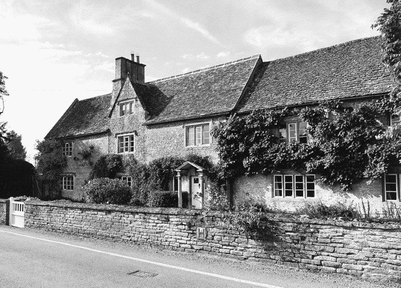
52. Manor Farm from the north-east
Apart from the lord there were 3 other freeholders in 1279, one (William Silven) holding 4 yardlands from the d'Oillys for 20d. rent, and another (John of Buckland) holding 2 yardlands from the Hospitallers of Quenington (Glos.) for 24s.; the third held a yardland for 2 lbs of pepper a year, and ½ yardland in villeinage, together with free and villein land in neighbouring parishes. All the other inhabitants were unfree peasants, of whom 10 each held a yardland for 3s. 9d. rent and labour services worth 6s.; another 3 each held ½ yardland for half the rent and services, suggesting only minimal fragmentation of holdings since the 11th century. A single cottager had just 2 a. for rent of 2s. 8d. a year. (fn. 24) Possibly there were other, unrecorded inhabitants, since in 1316 a total of 23 people paid tax on moveable goods collectively worth £46 17s. 4½d., an average of 40s. 9d. per head. In 1327, 28 tax-payers were assessed on moveables worth £57 10s., an average of 41s., though individual wealth varied greatly: one person paid 6s., and eight paid 3s. or more, while twelve paid under 2s. each. (fn. 25)
Long-term depopulation following the Black Death may have affected Kencot badly, since only 28 people above the age of 14 paid poll tax in 1377, albeit probably well below the total eligible. (fn. 26) The parish's fortunes during the late 14th and 15th centuries are, however, unrecorded.
The 16th to 18th Century In 1524 only seven inhabitants paid tax in Kencot, of whom the wealthiest, John Edmonds, was probably lessee of the manor. (fn. 27) In the 1540s his successor Bartholomew Platt was taxed on goods worth £20, while another six yeomen paid tax on goods worth between £3 and £8, three on goods worth £2, and four on £1 each. (fn. 28) By 1559 the highest taxpayer was again the lessee of the manor, Francis Yate, assessed on £9; he remained prominent in 1577 when he was taxed on £7-worth of goods, while two yeomen families, the Turners and Greens, were assessed on £8 and £3 respectively. (fn. 29) In 1581 Adam Turner and Thomas Green were still assessed on £3 each, while Richard Palmer, a yeoman sharing a tenancy with the Yates, paid on £5, and another farmer on £7. (fn. 30) The pattern of wealth points to an increasing characteristic of Kencot: the presence of resident gentry such as the Yates, occupying the larger houses and sometimes land under absentee landlords, alongside local yeoman farmers (some of them fairly prosperous) who actually farmed the land. (fn. 31)
A similar pattern continued during the 17th century, when the Yates (by then themselves absentee lords) leased the manor house to resident gentry, and its land to the local Turners. (fn. 32) In 1662 William Hammersley, taxed on 9 hearths probably at the manor house, had the largest dwelling, followed by the rector, taxed on 7 hearths; Francis and Adam Turner (5 hearths each) clearly occupied houses of some size, one of which may have been Manor Farm (Fig. 52). Adam Turner the elder and two others were taxed on 3 hearths each, though another eight people paid on only 2 hearths, and four on only one, while in 1665 two inhabitants were exonerated through poverty. (fn. 33)
The pattern reflects the domination of Kencot in the 16th and 17th centuries by a small but prosperous group of yeoman farmers, people who in the late 18th century could sometimes borrow with ease as much as £600. (fn. 34) Their prosperity is confirmed by the affluence of their lifestyle and furnishings, as displayed particularly by the Turners as tenants of the manorial estate. From the early 17th century, when their relatives the Yates acquired the freehold of the manor, the Turner family held the farm on long leases, which were bequeathed in their wills: Thomas in 1635 and Francis in 1645 each left the property to their sons, while Adam (d. 1662) left it to his wife in lieu of dower, and his son, also Adam (d. 1697), left it with his other possessions to the widow of his son Charles. (fn. 35) The family also farmed the extensive glebe, and by 1685 had become so entrenched that Adam Turner, 'having long rented the demesne or farmlands', had them 'ascribed to him as well as his own, [these lands] not being distinguished by most inhabitants'. (fn. 36) The Turners also held other lands both in and outside the parish, notably in Clanfield and Alvescot, again on long leases. (fn. 37)
Mixed farming typical of the region continued. Crops in the 1630s included wheat, barley, oats, and maslin, (fn. 38) and as in neighbouring parishes sheep were probably important from the Middle Ages: (fn. 39) in 1549 the three main Kencot landowners together had 650 sheep, the principal, Humphrey Edmonds, being taxed on 160. (fn. 40) In 1615 a 3-yardland holding sold to Francis Turner included pasture rights for 90 sheep, (fn. 41) and in 1697 Adam Turner left wool worth £23. (fn. 42) Coppicing and sale of timber were mentioned in the 17th and 18th centuries, and the usual ancillary agricultural activities were mentioned throughout, among them dairying, cheesemaking, bee-keeping, and poultry-raising. (fn. 43)
Customary copyhold grants apparently remained the norm in Kencot in the 1590s, when a yardland was granted in the manor court to John Yate and his son Francis for their lives, after payment of heriot. (fn. 44) Kencot tenants of Broadwell manor continued to hold by copy in the 17th century, (fn. 45) but how late this continued on Kencot manor is unknown. Larger farms were apparently being let on long leases by the 16th and 17th centuries, among them a farm granted by Thomas Wenman to Bartholomew Platt for 40 years c. 1545, and the former demesne let to the Turners. (fn. 46) Such grants were presumably succeeded, as elsewhere, by shorter leases during the 18th century, but no evidence has been found before the late 19th century, when standard 14-year leases were apparently common. (fn. 47)
After 1665 no comprehensive accounts of taxable wealth in Kencot survive before 1785, when the manor had twice been sold (in 1708 and the early 1760s), and the parish had been inclosed (in 1767). (fn. 48) By far the largest farmer in the 1780s was the lord, the attorney William Stephens, who paid land tax of nearly £24 for some 320 a. which he farmed directly. The next largest was John Stevens, who paid over £14 tax for an estate of 189 a. leased from the non-resident Phillips Lyttleton and for his own freehold, a total of perhaps 290 a. altogether. The rector's glebe, about 235 a., was let to a farmer who paid just over £13 tax. Another 60 a. or so, owned by the non-resident Richard Hall, was farmed by one of the Nalders of Alvescot, presaging a pattern which became characteristic of Kencot during the 19th and 20th centuries: increasingly its farmland was owned by outsiders and worked from outside the parish, many farmers (like the Nalders) owning considerable property elsewhere and using the Kencot land merely to increase their holdings.
The 19th and 20th Centuries Between 1785 and 1831 the broad pattern of wealth and farming remained relatively stable, though not all farms remained in the same families throughout. (fn. 49) The Stephens family were still resident at the death in 1808 of William Stephens's widow Ann, though by 1789 they leased the manorial farm (still assessed at around £23 land tax) to the Whitehorns as tenant farmers; at Ann's death her personal estate was valued at £1,500. (fn. 50) The glebe and the Lyttleton estate were let by 1800 to William Ilott, who paid land tax of £20; the Stevenses whom he had replaced were still present but farmed much less land. By 1831 the Stephenses' heir Humphrey Tuckwell again ran the manorial farm himself, but the glebe was farmed from outside the parish by the Hobbs family, and the former Lyttleton estate by John Large, one of a prominent Broadwell farming and landholding family who acquired the whole of the Stephens estate (including the remains of Kencot manor) in 1839. (fn. 51)
The 1840s to early 1860s, following the break-up of the former manor, saw the emergence of between five and seven farms of over 100 a. each. (fn. 52) Much of the manor farm (over 200 a.) was farmed by John Large until the early 1850s, but after he sold much of his land to a relative it was let to the farmer William Hobbs, who already farmed 100 a. in the parish, and who accumulated 327 a. by 1871, when he employed 15 labourers; he was, however, non-resident, having substantial property elsewhere in the area. The rectory farm, between 260 and 280 a., was let at first to Thomas Wakefield, a major local figure resident in Kencot, who in all farmed nearly 450 a. in the area, and who moved to another Kencot farm in the 1850s; later lessees were members of the Oakey family, who also farmed other land in Kencot. Kencot Hill farm (c. 130 a.), owned by William Hervey of Bradwell Grove, was let at first to John Large and in the 1850s and 1860s, with other land, to James Maisey, who was succeeded by various tenant farmers into the 20th century.
Throughout that period the rectory farm remained the largest, most of the other large farms comprising around 120–140 a., and three or so others having under 100 a. each. Three farms were still owner-occupied in the 1840s, but thereafter all were let to tenants, most of them prominent local farmers and landowners living outside the parish. Perhaps partly for that reason there was little stability, with the same few tenants often moving from one farm tenancy to another and sometimes renting more than one farm at a time; only rarely did more than one generation retain a particular farm, though occasionally several members of the same family were present simultaneously, among them the Oakeys or Hobbses.
The 1870s to 1910s saw Kencot further dominated by major farmers from neighbouring parishes: of particular note were Richard Pinnell of Westwell, farming 620 a. with 12 labourers in 1871, the Craddocks and William Porter of Broadwell, William Pinnock of Southrop, and the Nalders of Alvescot. Among other major farmers only Augustus Gillett, one of another major west Oxfordshire farming family, was resident, moving to Kencot from Lower Haddon in the late 1870s as tenant of the 230-a. manorial farm, where he remained to the end of the century, employing 13 labourers. (fn. 53)
Throughout the 19th century and into the 20th farming remained mixed, with an overall shift towards arable compared to before inclosure. By 1840 the parish was over 79 per cent arable, some of it on converted former common in the Downs in the north of the parish; only 10 per cent was pasture, and the area of meadow remained very low at just over one per cent. The balance on individual farms was broadly similar, John Large's manorial farm being 78 per cent arable in the 1840s, and the glebe farm almost entirely arable later in the century. (fn. 54) Another farmer's stock in 1875 included maize, turnips, swedes, mustard seeds, and corn, as well as hops, malt, and brewing equipment. (fn. 55) Despite the bias towards arable, sheep remained important: sales were mentioned throughout the century, and a flock of 151 was sold by one owner in 1875. (fn. 56) In 1914 the parish remained 71 per cent arable, the chief crops being wheat (18 per cent), barley (22 per cent), swedes and turnips (10 per cent), and oats (8 per cent), with a few mangolds and potatoes. Cattle, horses, sheep, and to a lesser extent pigs were kept in average numbers for the area, though as elsewhere sheep farming had declined since 1909. (fn. 57)
From the 1910s to 1930s there were only three large farms, each over 150 a.: long-term resident tenants were the Eustaces at Home farm (the former rectory farm) and, from around 1924, A.H. Foddy at Kencot Hill farm. Another three smaller farmers were also established: the Hewitts at Asthall farm (c. 100 a.) by 1924, the Foreshews at Malthouse farm, and William Taylor at Hillview farm, the last two just under 100 a. each. (fn. 58) In 1941 the main crops recorded were wheat with other corn and oats (c. 139 a.), barley (114 a.), and a mixture of potatoes, turnips, swedes, kale, rape, clover, and sainfoin, together c. 54 acres. Some 188 a. was under grass, but land-use in the rest of the parish is not known. Home farm (with 4 labourers), Asthall farm, and Kencot Hill farm (with 2 labourers) were all predominantly arable; fertilizers were used only on the best-run farms, and only two had tractors. There seems to have been a distinct labour shortage, presumably because of the war, and some seasonal water shortages. Sheep-farming had decreased considerably since the early 20th century, no more than 51 sheep being recorded. By contrast, commercial poultry-raising had increased: all the main Kencot farms had large numbers, with 234 at Home farm, 80 at Asthall farm, 40 at Kencot Hill farm, and between 30 and 40 at Rectory Field and Hillview. The Foreshews' Malthouse farm, with 560, had been a poultry farm since at least the 1920s; even larger stocks had been kept there before the war, but feeding problems and lack of capital had diminished their numbers, and some of the land was sold. (fn. 59)
All but Hillview farm continued in the 1960s. (fn. 60) Much of Kencot Hill farm's land was lost to Broadwell aerodrome during the Second World War, and in the 1970s the house and most of its land were sold separately. (fn. 61) Both Home and Asthall farms remained in 2003, the first comprising 200–300 a., and the second 400 acres. Mixed farming continued until the national foot-and-mouth crisis of 2001, which caused one Kencot farmer to abandon cattle-rearing and to concentrate on wheat and barley. (fn. 62)
Trades and Crafts
William Brown of Kencot (d. 1502) may have been a successful merchant, having established himself in Oxford, Thame, and High Wycombe (Bucks.). (fn. 63) If so he was untypical of Kencot tradesmen generally, though William Rose, a Kencot mercer, left over £487 on his death in 1680, (fn. 64) and in 1764 Joseph Stead of Faringdon (then Berks.) set up a mercer's shop in the parish. (fn. 65) Among the more usual rural tradesmen bakers were recorded from the 1680s, (fn. 66) and one of the Hewlett family was a slater in 1622, (fn. 67) his descendants continuing as slaters, plasterers, and sometimes carpenters until the end of the 19th century. Other craftsmen recorded between 1699 and 1775 were a cordwainer, a wheelwright, a carpenter, a shoemaker, and a soap-boiler. (fn. 68) Henry Bolton, a Witney master blanket-weaver, acquired a house in Kencot from his uncle Francis Edmonds in 1798, which he later sold. (fn. 69)
Thirteen inhabitants were said to be employed in trade and crafts in 1831, (fn. 70) and during the later 19th century the usual rural tradesmen continued to be recorded: baker, butcher, carpenter, cordwainer or shoemaker, and slaters and plasterers, together with smiths and carters. (fn. 71) Small-scale malting was pursued throughout the 19th century by farmers and other tradesmen, among them a baker (in 1841) and corn dealers (in 1853 and 1876). (fn. 72) A sawyer was mentioned in 1871, a coal merchant in 1881, and a midwife and a builder at the beginning of the 20th century, (fn. 73) and as elsewhere many women worked as laundresses, dressmakers, seamstresses, or charwomen. During the agricultural depression of the 1870s and 1880s unemployed labourers sometimes described themselves as carters, couriers, gardeners, or grooms, though some were listed as paupers in 1881; many had lodgers, either other labourers or servants. In addition, Kencot seems to have had more shopkeepers than might be expected, particularly grocers, who sometimes combined the trades of baker or draper; often the village had up to three at any one time. From the 1890s there was also a dealer in horses and pigs and a fruit-grower, and in the 1930s a resident advertized himself as 'cycle and wireless agent, fruiterer, and general dealer', and hired out motor cars. (fn. 74)
The name Quarr acre, recorded in 1685, suggests small-scale quarrying in the north of the parish, and an 'old' stone quarry covering half an acre was mentioned at inclosure in 1767, when a new public quarry of 2 a. was opened for road repairs. (fn. 75) A stone-digger was mentioned in 1861. (fn. 76)