A History of the County of Shropshire: Volume 10, Munslow Hundred (Part), the Liberty and Borough of Wenlock. Originally published by Victoria County History, London, 1998.
This free content was digitised by double rekeying. All rights reserved.
A P Baggs, G C Baugh, D C Cox, Jessie McFall, P A Stamper, 'Munslow', in A History of the County of Shropshire: Volume 10, Munslow Hundred (Part), the Liberty and Borough of Wenlock, ed. G C Baugh( London, 1998), British History Online https://www.british-history.ac.uk/vch/salop/vol10/pp151-167 [accessed 27 July 2024].
A P Baggs, G C Baugh, D C Cox, Jessie McFall, P A Stamper, 'Munslow', in A History of the County of Shropshire: Volume 10, Munslow Hundred (Part), the Liberty and Borough of Wenlock. Edited by G C Baugh( London, 1998), British History Online, accessed July 27, 2024, https://www.british-history.ac.uk/vch/salop/vol10/pp151-167.
A P Baggs, G C Baugh, D C Cox, Jessie McFall, P A Stamper. "Munslow". A History of the County of Shropshire: Volume 10, Munslow Hundred (Part), the Liberty and Borough of Wenlock. Ed. G C Baugh(London, 1998), , British History Online. Web. 27 July 2024. https://www.british-history.ac.uk/vch/salop/vol10/pp151-167.
In this section
MUNSLOW
Munslow parish lies along the north-west side of Corve Dale. (fn. 1) Aston Munslow, one of its two surviving villages, is on the principal road down the dale, c. 16 km. south-west of Much Wenlock and c. 10 north-east of Craven Arms. Munslow, the other village, is just over 1 km. north-east of Aston Munslow, and other smaller or shrunken settlements are strung out further to the northeast.
Until 1883 the parish's six townships comprised 3,545 a. (fn. 2) (1,435 ha.) and included two detachments, one to the north at Topley (101 a., 41 ha.), a part of Lower Millichope township surrounded by Eaton-under-Heywood parish, and the other to the south at Little Poston, a small township (343 a., 139 ha.) almost completely surrounded by Diddlebury parish. (fn. 3)
The two southern townships in the main part of the parish, Aston and Munslow, represented the Domesday manor of Aston (fn. 4) and probably a parish as originally formed out of Diddlebury parish: Aston's name records its geographical relation to Diddlebury whose parish surrounds Aston and Munslow townships on three sides (fn. 5) and may have done so completely.
Of the parish's three northern townships Lower Millichope was formed by the parochial division of the Domesday manor of Millichope c. 1115 when Wenlock priory's parochial rights over Upper Millichope were confirmed but Lower Millichope was assigned to Munslow parish. (fn. 6) It was presumably after the two estates were separated manorially, by subinfeudation, that c. 101 a. of woodland on Topley hill was allocated to Lower Millichope as common (fn. 7) and so eventually to Munslow parish. Millichope's parochial connexions before c. 1115 are uncertain. (fn. 8) Thonglands was a separate parish until its union with Munslow in 1442 and probably included Little Poston as a detached township. (fn. 9) In 1066 Broadstone was part of Stanway manor which was in the medieval parish of Rushbury; within the next twenty years, however, Broadstone became part of Shrewsbury abbey's possessions and was separated from Stanway. (fn. 10) Broadstone formed part of Munslow parish by 1589, but when and how it became part of the parish are unknown. (fn. 11)
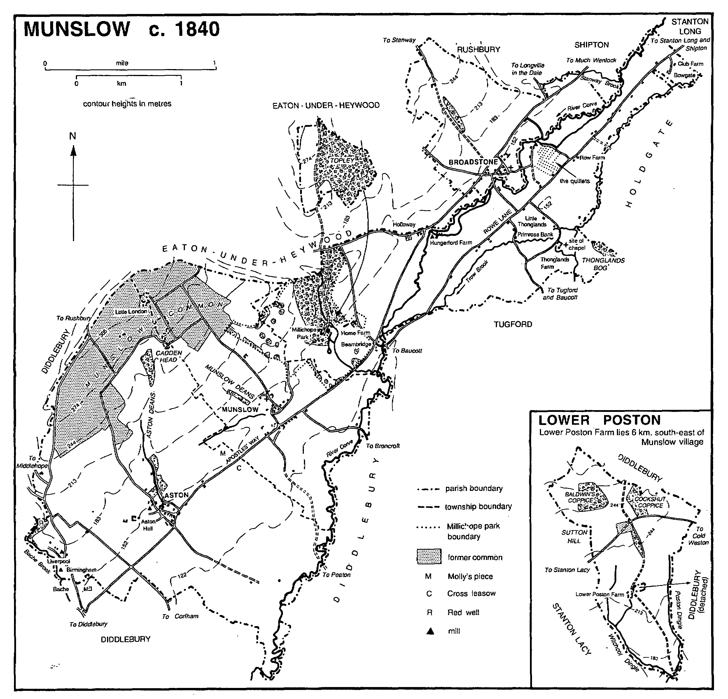
MUNSLOW c. 1840
West of Aston and Munslow townships the parish boundary runs mainly along the limestone ridge separating Hope Dale from Corve Dale, to the east along the river Corve. Further north the Corve marks the western parish boundary above and below Broadstone; the eastern boundary follows Trow brook except around Thonglands, where, however, a tributary of Trow brook marks part of it. Otherwise around Thonglands, Broadstone, and Topley and across the southern end of the parish the boundary follows artificial features, save for short stretches coinciding with minor streams. (fn. 12)
The main 19th-century changes to the civil parish were the transfers of detachments at Topley (1883) and Little Poston (1884) to Eaton-under-Heywood and Hopton Cangeford C.P.s respectively. (fn. 13) The area of Munslow C.P. was thus reduced to 3,101 a. (fn. 14) (1,255 ha.). In 1967 Munslow C.P. was enlarged by 450 ha. in Upper Millichope, Hungerford, and Topley taken from Eaton-under-Heywood C.P. and by c. 1 ha. from Holdgate C.P. At the same time the part of Bache Mill in Munslow was transferred to Diddlebury C.P. and another small area to Tugford C.P. (fn. 15) This article deals with the whole of the parish as it was in the earlier 19th century, apart from Lesser Poston, treated separately. (fn. 16)
The four townships west of the Corve have similar physical characteristics: they slope up from alluvial soils along the right bank of the river (c. 120 m.) to higher ground (up to c. 325 m. north of Little London) occupied historically by woods and commons. The settlements stand at c. 150 m., by springs and streams at the foot of shallow valleys (deans) cut through the Aymestry Group limestone and Upper Ludlow Shales that form the higher ground and supply the local building and road stone. South of Aston Munslow village and north-east of Thonglands Farm the geology is different, the drift consisting of red marls, cornstones, and sandstones of the Ledbury Group, while west and south of Thonglands Manor is Downton Castle Sandstone. (fn. 17)
Streams draining south and east into the Corve include Bache brook, so called in 1660, (fn. 18) Dean brook, (fn. 19) on which Munslow stands, Millichope brook, (fn. 20) and Stanway brook. (fn. 21) Trow brook flows south-west into the Corve near Thonglands, whose name may allude to the confluence. (fn. 22)
By 1653 and until the 19th century the road from Much Wenlock to Craven Arms and Ludlow, south-west of Munslow village and probably as far as the parish boundary, was known as the Apostles' Way. (fn. 23) It was turnpiked in 1756 and disturnpiked in 1867. (fn. 24) There were tollgates at Munslow and 1.3 km. north-east at Beambridge. (fn. 25) In the 18th century minor routes led south-east out of the road. (fn. 26) From Munslow Churley way (fn. 27) ran, perhaps past Marston, (fn. 28) to Corfham and Peaton, and a second route, via Brook House (presumably the Brook Hall of 1589), (fn. 29) ran to Baucott and Broncroft. Minor ways also led from Broadstone to Thonglands and Tugford, and from Beambridge to Baucott. North and west from the Wenlock-Ludlow road led the ways from Diddlebury to Middlehope via Bache Mill; from Beambridge and from Hungerford to Upper Millichope and Rushbury (the former a new road of c. 1835); (fn. 30) and from a point 1 km. north-east of Broadstone to Longville in the Dale, probably the Bromedge Way of 1662. (fn. 31) A supposed Roman road, believed to run from Greensforge (Staffs.) to central Wales (fn. 32) and known locally as Rowe Lane, originally ran from Shipton parish along the slight ridge between the Corve and Trow brook to Beambridge; it was the Bridgnorth–Munslow road c. 1575 and was probably known in the 17th century as Marsh, or Bowgate (or Bodgate or Bog gate), Lane; (fn. 33) its modern name derives from Cuckolds' Row, the usual name for the squatter settlement along it in the 18th and 19th centuries. (fn. 34) From Rowe Lane tracks ran south to Tugford and to Holdgate, the latter crossing Trow brook by Agnes bridge, so called in the 16th century. (fn. 35)
Finds of Neolithic and Bronze Age material, crop marks, (fn. 36) and perhaps the mound from which Munslow was named (fn. 37) supply evidence of prehistoric activity. A barrow may have been destroyed at Thonglands in 1827, and Gills hill (the Gill hill in 1685) in Aston village was conjectured in the early 19th century to be a British burial mound. (fn. 38)
In 1086 Aston manor had a recorded population of 22. (fn. 39) In 1327 subsidy was paid by 7 in Munslow (presumably including Aston), 6 in Broadstone, and 13 in Millichope (which, besides Lower Millichope, may have included Upper Millichope and Thonglands). (fn. 40) About 1490 Shrewsbury abbey had 10 tenants in Broadstone. (fn. 41) There was at least one house outside the parish's main settlements in the Middle Ages, at Red well on the western parish boundary, mentioned in 1267 (fn. 42) and 1652–3. (fn. 43)
In 1676 the parish's adult population was 404; (fn. 44) 82 houses then paid the parish rate, 9 more than in 1663. Settlement in Broadstone (c. 8 ratepaying houses in 1676) and Lower Millichope (3) seems to have continued small in scale. Aston (27 ratepaying houses), Munslow (20), and Thonglands (c. 24) townships provided most of the increase; although the Thonglands figure probably included part of Hungerford (a settlement mainly in Eaton-under-Heywood parish), there had been some recent cottage building in Thonglands. Larger houses were concentrated in Aston and Munslow, particularly the latter. (fn. 45) By then there were squatters in Aston wood, later a hamlet known as Bache Mill, parts of which were called Liverpool and Birmingham; (fn. 46) at Broadstone; in Millichope wood; and on Munslow common, a settlement known by the 1840s as Little London. (fn. 47) Building of the cottages later known as Cuckolds' Row had begun by the mid 17th century, (fn. 48) and there were c. 20 in the 1840s. (fn. 49)
The population, 610 in 1801, rose to a peak of 767 in 1851 and fell to 475 in 1901 as cottages were demolished and multiple occupation declined. (fn. 50) Broadstone village shrank considerably in the century after 1770, a change to which the late inclosure of open-field land may have contributed. Half a dozen houses with their outbuildings were demolished, and the network of lanes serving them fell into disuse. One or two new cottages were built and, beyond the old village to the north-east, Broadstone Farm (c. 1800) with modern buildings. (fn. 51) Cottages were also abandoned along Cuckolds' Row, at least six being demolished between 1843 and 1891. (fn. 52)
The population and number of dwellings continued to fall until the mid 20th century. (fn. 53) Thereafter the attractions of rural residence for those who could afford a car halted the population decline and led to the renovation of dilapidated buildings and the construction of new houses (especially in Aston Munslow) for newcomers. Other and less welcome changes were the closure of shops and businesses and the loss of bus services. (fn. 54)
Aston Munslow and Munslow villages, roughly equal in size by c. 1990, (fn. 55) and what is left of Broadstone village exhibit similar characteristics, though Munslow may have developed as a settlement later than the others. (fn. 56) All stand away from the main road, with buildings widely spread and served by networks of lanes, tracks, and footpaths. In Munslow lanes loop round a spur of ground called Castle Hill in 1834 and the Rock in the later 20th century. (fn. 57) Part of it was common called the village green, inclosed and sold in 1847. (fn. 58)
A cottage at Hungerford has a cruck truss. (fn. 59) Where other buildings in the parish (fn. 60) retain 17th-century and earlier elements much of the work is box framed, as at Thonglands Farm, the Crown inn and the Chains in Munslow village and the White House, Lower Farm, the Swan inn, Tudor Cottage, Arbour Cottages (dated 1632), and numbers 8–9 in Aston Munslow. Aston Hall, probably the parish's most important house in the 16th and 17th centuries, is stone. So, externally, is the Old School House in Munslow, a fine L shaped house with stone mullioned and transomed windows, built in 1658 apparently for John Baldwin (d. 1680) and his wife Abigail; Baldwin's will mentions the wainscot chamber over the buttery. (fn. 61) In the 18th and 19th centuries stone, readily got in the parish, became almost ubiquitous, both for superior houses, such as the new rectory (before 1793) and Miller House (probably c. 1799) in Munslow and Hungerford Farm (c. 1800), and for farm buildings and squatters' cottages.
Before the mid 19th century brick was rarely used, though it can be seen in a 17th-century range at Munslow Farm, in the mid 18th-century Crown inn, Munslow, and in Little Thonglands, a small, polite 18th-century building. Thereafter brick became commoner, being used to extend and raise cottages.
Stone, however, was consistently employed in the 1830s in a wholesale rebuilding programme in the Greek style on the Millichope Park estate. Most of the buildings have raised pilasters to their principal elevations, as on the north lodge to the park. The most ambitious scheme was Home Farm, remodelled c. 1836 (fn. 62) around the sides of a courtyard on whose fourth side is a free-standing kennels block surmounted by a cupola. Nearby at Beambridge a polite building of four bays and two storeys with a low hipped roof was constructed; at least part of it probably served as the Millichope Park laundry, the whole being called the Old Laundry in the 20th century. A row of cottages (1838), with a projecting and pedimented central bay, stands to the northeast. Also at Beambridge is a gothick smithy once surmounted by a crenellated parapet; (fn. 63) it is unlike the other buildings in style and may be of a slightly different date.
Alesellers at Aston Munslow, Munslow, and Thonglands were licensed in the 17th century. (fn. 64) In the 18th and early 19th century the main, and long the only, public houses were the Crown at Munslow and the Swan at Aston Munslow, both licensed in 1790 (fn. 65) and open two centuries later. The Crown may once have been the 'court house' of Munslow hundred, (fn. 66) while the Swan was also known as the Hundred House, (fn. 67) probably from meetings of the Lower Munslow divisional magistrates there. (fn. 68) Two other public houses had long lives: the Seven Stars north-east of Broadstone, open by 1851 and still in 1941, and the Butcher's Arms at Primrose Bank in Thonglands, open by 1851 and until c. 1920. (fn. 69)
In the early 19th century (fn. 70) it was apparently still within recollection that banners, including the 'great banner' of the Crucifixion and of St. Michael (patron of the church), were borne in annual procession from Munslow village along the Apostles' Way (fn. 71) to the Aston boundary: there the banner of the Cross was fixed to the fence of Cross leasow, (fn. 72) a well beside the road (in Molly's piece) was dressed, and refreshments were enjoyed. Beyond Aston, on the western edge of the parish, was another holy well, a healing well called Red (or Red Wall) well from the local soil colour; still in the mid 18th century the cured hung up their crutches nearby.
A Sunday bear-baiting was presented in 1606. (fn. 73) Munslow common was hunted over in the 1820s, (fn. 74) and wakes may have been held there. (fn. 75) There were 70–100 members of friendly societies living in the parish in the early 19th century, (fn. 76) and in the 1840s and later Munslow had a cricket club. (fn. 77) In 1847, at the inclosure of Munslow common, 4 a. near Little London were allotted as a recreation ground; (fn. 78) it was sold in 1968 and deregistered as common in 1973. (fn. 79) When a youth club was formed in the late 1940s the Millichope estate made a converted cowshed available; in due course it became the parish hall, known as Beambridge club room. (fn. 80)
Four Parliamentarian troopers were buried at Munslow in 1645 after Royalists had forced the Parliamentarians' abandonment of Broncroft castle. (fn. 81)
Besides members of the Lyttelton (or Littleton) family, (fn. 82) notable people connected with the parish were Richard Baldwin (1616–89), a Paracelsian physician whose nephew Richard Baldwin (licensed 1674) and grandson Edward Baldwin (licensed 1702) also practised medicine locally, (fn. 83) and Samuel Pountney Smith (1812– 83), architect, who was a native. (fn. 84)
MANORS AND OTHER ESTATES.
In 1066 Almund (Elmund) held ASTON. An extensive manor of 8½ hides, it was held in chief at Domesday by Roger of Montgomery, cr. earl of Shrewsbury in 1068, from whom the sheriff Reynold of Bailleul then held it. (fn. 85) The earl's tenancy in chief ended in 1102, (fn. 86) and by 1115 the sheriff's interest had ceased too. (fn. 87)
Aston, which included Munslow, (fn. 88) was held in chief by Richard Banastre in 1115. Richard's son and heir Thurstan Banastre (fl. c. 1150) was succeeded as tenant in chief by his daughter Maud, wife of William de Hastings (d. by 1182). She had the lordship until her death c. 1222 when it passed to their son William (d. c. 1225). William's son Sir Henry (fn. 89) held Aston and Munslow in chief as ¼ knight's fee by 1243. (fn. 90) From him (d. 1250) the tenancy in chief appears to have descended from father to son through Sir Henry, at first a minor (fn. 91) (d. c. 1269), Sir John (fn. 92) (Lord Hastings 1290, d. 1313), John, Lord Hastings (fn. 93) (d. 1325), Lawrence, Lord Hastings (cr. earl of Pembroke 1339, d. 1348), and John, earl of Pembroke (fn. 94) (d. 1375), to John, earl of Pembroke, who died childless in 1389. It seems likely that the tenancy in chief was afterwards disputed. Under a settlement of 1372 it should have passed to William Beauchamp, Lord Bergavenny, a kinsman of the last John, earl of Pembroke; (fn. 95) Beauchamp had the advowson of Munslow church by 1396. (fn. 96) Nevertheless Reynold, Lord Grey of Ruthin, Pembroke's heir general, (fn. 97) was named as tenant in chief of Aston in 1401. (fn. 98) It seems that by then a compromise had been reached, involving separation of the tenancies in chief of Aston and Munslow. (fn. 99)
The tenancies in chief may have been the more easily separated c. 1400 because Aston and Munslow had been separately subinfeudated since the mid 13th century or earlier. In the 1160s, Aston and Munslow may have been held together in fee, under Maud de Hastings, by Robert son of Waukelin, who forfeited his lands for his part in the rebellion of 1173, but whose widow Amice retained an interest in Munslow as late as 1199. (fn. 100)
The tenant in chief of Aston in 1428 was Sir John Talbot, Lord Furnivalle, (fn. 101) cr. earl of Shrewsbury in 1442. He died in 1453 (fn. 102) and under a settlement of 1452 his tenancy in chief descended successively to his sons Sir Lewis (d. by 1458) and Humphrey (later Sir Humphrey). (fn. 103) It seems afterwards to have merged in the terre tenancy, which Humphrey acquired in 1463. (fn. 104)
Aston was subinfeudated by the mid 13th century, when Adam Hertwell's son John was terre tenant. By 1255 Aston had passed to John's heir, a minor in the custody (during his overlord's minority) of Geoffrey of Lusignan. (fn. 105) By 1284 Adam Hertwell was in possession. (fn. 106) John Hertwell was lord in 1348 (fn. 107) and Richard Hertwell in 1375 when he was leasing the manor to John FitzWarin, (fn. 108) allegedly descended from the FitzWarins of Whittington by an illegitimate line. (fn. 109) FitzWarin acquired the freehold before his death in 1401 and his son William succeeded. (fn. 110) In 1463 Edward FitzWarin quitclaimed it to the overlord Humphrey Talbot. (fn. 111)
From Sir Humphrey (d. 1493) (fn. 112) Aston descended successively to his grand-nephew John Grey, Viscount Lisle (d. 1504), (fn. 113) and to Lisle's daughter and heir Elizabeth, Lady Lisle and countess of Devon (fn. 114) (d. 1519). In 1529 it was held by Sir Arthur Plantagenet, Viscount Lisle, second husband of the countess of Devon's aunt and heir Elizabeth. In 1529 Lady Lisle's son (by her first husband) Sir John Dudley sold his reversionary interest in the manor to Sir John Alleyn, who sold it next year to John Smith, (fn. 115) a baron of the Exchequer from 1539. (fn. 116) Smith (kt. by 1541) (fn. 117) presumably came into possession on Viscount Lisle's death in 1542.
Smith's widow Agnes (d. 1562) (fn. 118) had Aston, (fn. 119) and from her it descended with Wootton Wawen (Warws.) until 1758, (fn. 120) except that Aston passed directly to Sir Francis Smith in 1605, (fn. 121) and that Charles Carington (or Smith), Viscount Carrington (d. 1706), was evidently succeeded by his cousin's son (fn. 122) Francis Smith (d. 1721), (fn. 123) who was succeeded by his son (fn. 124) Francis Smith (or Carington), (fn. 125) to whom Wootton passed in 1748.
Aston is presumed to have descended from William Smith (d. 1758) (fn. 126) to his grand-nephew John Wright, in possession by 1787, (fn. 127) perhaps through John's mother, Mrs. Constantia Holford. (fn. 128) John died in 1792 and was succeeded by his son John (fn. 129) (d. 1826); the latter's grandson and heir J. F. Wright (d. 1868) was in possession by 1843 (fn. 130) and was followed by his nephew E. C. Wright. (fn. 131) In 1911 Wright sold Aston Hall and 100 a. to P. G. Holder, who sold that property next year to J. I. Benson. In 1978 Maj. D. Benson sold the Hall and 13 a. to R. N. Broad. Broad sold it in 1985 to Cdr. J. L. Skinner, who sold it in 1988 to Mr. and Mrs. P. A. G. Cressall. (fn. 132)
Aston Hall (fn. 133) is a stone H plan building, but a two storeyed porch gives the front (south-eastern) elevation a symmetrical E shaped appearance. Timber framing in the north-east wing—large jowled posts and parts of the roof— and a break-back at the south-west corner indicate the incorporation of a timber-framed building to the west when the Hall was built, perhaps c. 1665; a skewed stack may be later. The plan, a widespread use of panelling and bolection moulding, and the quality of the principal staircase all suggest the intention to create a substantial and superior gentleman's house. So too do the three gardens, walled in brick (with some diaper work) and partly terraced, and the household's stables at one end of a threshing barn, both perhaps contemporary with the remodelling of the house.
After the sale of Aston Hall in 1911 E. C. Wright retained 661 a. at Aston and c. 1914 he sold that property too to P. G. Holder. (fn. 134) In 1942 Holder sold it to the Ecclesiastical Commissioners, (fn. 135) and in 1963 the Church Commissioners sold Lower Aston Farm, 244 a. of a small estate that John Smith had owned in 1843. (fn. 136) The farmhouse is a late 16th-century L shaped timber framed building of two storeys; the south-east wing has an overhanging gabled end.
There were Stedmans at Aston by the 15th century. (fn. 137) In the 17th century one line lived in a house at the Bank, not now identifiable. Perhaps the main line lived, by the 16th century, at a house known by 1648 as the White House. (fn. 138) John Stedman (d. 1804) left the White House to his nephew Thomas Smith, who had c. 415 a. in 1808. (fn. 139) Smith's descendants lived there until 1945 when A. H. Davies bought it; (fn. 140) he sold it to Walter Purser in 1947.
The oldest part of the White House (fn. 141) would seem to be a three bayed range of mixed cruck and box frame construction. A dovecot too may be medieval. (fn. 142) In the late 16th century a cellared, box framed west wing was added, perhaps in place of a pre-14th-century range. The 17th century saw a first floor and chimney inserted in the medieval range and perhaps its casing in stone. In the late 18th century the house was modernized, refronted, and extended to the west. Walter Purser's daughter Jessie Constance, who formed a museum of country life there and opened it to the public from 1965 to c. 1986, gave the house to the Landmark Trust in 1990. (fn. 143)
Land owned by the Ludlow Palmers' guild passed in 1552 to Ludlow corporation which had 13 a. at Aston in 1562 (fn. 144) and 10 a. in 1843. (fn. 145) Vested in the trustees of Edward VI's charity, Ludlow, in 1846, the land was sold after 1876. (fn. 146)
The tenancy in chief of MUNSLOW may have been separated from that of Aston c. 1400, for William Beauchamp, Lord Bergavenny, is said to have sold what was probably the tenancy in chief to John Burley, Reynold, Lord Grey of Ruthin's brother-in-law. (fn. 147) Burley also acquired the terre tenancy of the manor, and the tenancy in chief presumably merged with it.
Munslow had been subinfeudated by 1255, when the terre tenants, evidently coparceners, were John de Chandurs, Nicholas Seymour, and Ermyntrude, a daughter of John Hertwell, son of John Hertwell, the late terre tenant of Aston. They held Munslow of a mesne lord, William de Venables, whose tenure was evidently resumed by the chief lord before 1285. Ermyntrude's daughter Agnes conveyed her share to Seymour and his wife Alice. Seymour predeceased Alice, who was in sole possession of their Munslow estate by 1285. She conveyed it to Robert de Beke and his wife Maud, Ermyntrude's sister; (fn. 148) Robert and Maud presumably possessed John de Chandurs's share, for by 1316 Robert was sole lord of Munslow. (fn. 149) Maud predeceased him c. 1324 (fn. 150) and by 1348 his son Nicholas de Beke (kt. 1348, d. 1369) was lord. (fn. 151) Sir Nicholas's heir was his daughter Elizabeth, who married and predeceased Sir Robert Swynnerton (d. 1386). (fn. 152) After Swynnerton's death Munslow seems to have passed to their daughter and heir Maud Peshall. (fn. 153) Maud's second husband (from c. 1388) was William Ipstones (d. 1399), (fn. 154) whose father Sir John (d. 1393) had Munslow manor, apparently as Maud's feoffee. (fn. 155) After William's death Maud may have had only a third of Munslow; in 1404 she and her third husband John Savage conveyed a third of the advowson to John Burley, (fn. 156) tenant in chief of the manor. The other two thirds of the manor may have passed in 1399 to William's daughters and coheirs Christine and Alice (fn. 157) and were apparently later acquired by Burley.
By 1428 John Burley's son William (d. 1458) was in sole possession. (fn. 158) Munslow passed to William's daughters, Sir Thomas Trussell's wife Elizabeth and Sir Thomas Lyttelton's wife Joan. The Trussells' share descended with Acton Trussell (Staffs.) until 1552 when John de Vere, earl of Oxford, (fn. 159) sold his moiety of Munslow manor to John Stringfellow. (fn. 160) In 1553 Stringfellow sold it to John Littleton, (fn. 161) rector.
Lady Lyttelton died a widow in 1504 and her moiety then passed to her son Sir William Lyttelton of Frankley (fn. 162) (d. 1507) and then to his son John (fn. 163) (d. 1532), who left it to his son John. (fn. 164) The last named had the moiety in 1556, (fn. 165) but it was soon acquired by his cousin John Littleton (d. 1560), former rector and the owner of the other moiety, who left the whole manor to his son Thomas (d. 1622). (fn. 166)
From Thomas it descended, presumably through his son Sir Adam (d. 1647) and Sir Adam's son Sir Thomas Littleton or Poyntz (d. 1681), to Sir Thomas Littleton, speaker of the Commons (1698–1700), son of the last named, (fn. 167) who sold Munslow in 1706 to his cousin Sir Littleton Powys (d. 1732), (fn. 168) who was succeeded by his grand-nephew Thomas Powys (d. 1767). In 1772 Thomas Powys's son Thomas (fn. 169) sold the lordship of the manor, without the manorial estate, to Robert, Lord Clive, whose descendant and heir Edward Herbert, earl of Powis, sold it in 1842 to the Revd. R. N. Pemberton of Millichope Park. (fn. 170) Munslow manor then descended with the Millichope Park estate. (fn. 171)
The Littletons' house was Munslow Farm, (fn. 172) an L shaped building with a brick wing of the 1660s or 1670s and an 18th-century stone wing. The upper parlour of the older portion of the house has some panelling and a series of 17thcentury painted cloth hangings, perhaps Flemish. (fn. 173)
The only real estate which Lord Clive bought with the manor of Munslow was the 'manor' house. By 1793 it had been divided into two dwellings (fn. 174) and its later history has not been found. The rest of the former Littleton estate had passed by 1793 to one Walker, a serjeantat-law, (fn. 175) who had 300 a. in the parish in 1801. (fn. 176) In 1833 his son Charles conveyed that estate by way of exchange to the Revd. R. N. Pemberton, who bought the lordship of the manor in 1842. (fn. 177)
Sir Edward Littleton, brother of the lord of Munslow, is said to have bought from John Lutley, before 1581, a considerable estate in Munslow owned by the Lutleys since the 13th century. (fn. 178) Sir Edward's son Sir Edward, cr. Lord Lyttelton in 1641 soon after his appointment as lord keeper, died in 1645 (fn. 179) leaving a daughter Anne his sole heir. She married her second cousin Sir Thomas Littleton or Poyntz, lord of the manor. (fn. 180) In the 1830s it was recounted that the Lutleys' 'manor house' had stood on an 'eminence'. Partly burnt down in the 16th century, its ruins were removed c. 1799 when a new stone house (later known as the Miller House) was built for William Wainwright to John Smalman's design. (fn. 181)
In 1428 William Baudewyn (fl. 1433) was listed with William Burley and Lord Furnivalle as a principal landowner; he was a Munslow freeholder, as were his descendants until the 18th century or later. (fn. 182) One of them, Richard Baldwin (fl. 1523), was ancestor of Earl Baldwin of Bewdley, prime minister 1923–4, 1924–9, and 1935–7. (fn. 183) A chief house that belonged to John Baldwin (d. 1605) passed to his son William (fl. 1620) and was possibly the 'Farm of Munslow' that Roger Baldwin, John's uncle, had bought from John Stringfellow (purchaser of a moiety of the manor) in 1553; for the house in which William Baldwin's son John lived in 1658 was called Munslow Old Farm House by 1838. It then belonged to the Revd. R. N. Pemberton and was later called the Old School House. (fn. 184)
In 1607 William Baldwyn of Elsich (d. c. 1614) sold a house, later called the Chains, to Thomas Varnolds, in whose family it remained until the early 19th century. (fn. 185)
LOWER MILLICHOPE was separated parochially from Upper Millichope c. 1115 (fn. 186) and manorially, perhaps earlier, by subinfeudation. The prior of Wenlock was overlord, so described until 1420 or later. (fn. 187)
Peter de Lacy held the manor under the prior in 1255. (fn. 188) Peter's heir was apparently William de Schippeye's wife Amice. In 1293 the couple exchanged the manor with Philip Burnell (d. 1294). (fn. 189) During the minority of Burnell's son Edward the manor was among those given in custody to Guncelin of Badlesmere (d. 1301). (fn. 190) From 1307 until 1542 Lower Millichope descended with Acton Burnell. (fn. 191)
About 1544 Sir John Dudley, Viscount Lisle, sold his Lower Millichope estate, although no mention was made of the manorial rights, to Richard Adams, who in turn sold it in 1544 to Robert More of Thonglands, (fn. 192) already a Lower Millichope landowner. (fn. 193) More (d. 1545) (fn. 194) was probably succeeded by Edward More (d. 1558), whose heir was his brother Thomas. (fn. 195) Thomas or a namesake was succeeded in 1620 by his son Charles (d. 1646). (fn. 196) The claimed manor of Nether Millichope was an estate which, in 1685, Charles's son Thomas (d. 1689) (fn. 197) settled on his son Henry (d. 1689) (fn. 198) and daughter-in-law Mary. (fn. 199) Henry's son Thomas was lord in 1752. On his death without surviving sons in 1767 (fn. 200) Lower Millichope passed to Thomas More's daughter Catherine (d. 1792), who left it to her cousin Robert Pemberton (d. 1794). Robert's son Thomas (fn. 201) (d. 1832) was succeeded by his nephew the Revd. R. N. Pemberton (d. 1848), who left most of his estates to his cousin C. O. Childe (from 1849 Childe-Pemberton). Childe-Pemberton died in 1883, and his son C. B. Childe-Pemberton (Childe from 1884), (fn. 202) who had been offering the Millichope Park estate for sale since 1886, (fn. 203) sold it in 1896 to Capt. H. J. Beckwith (d. 1927), heir of a Durham landowning family, whose father had been rector of Eaton Constantine 1832–88. (fn. 204) Beckwith's daughter Kathleen Frances Malebisse (d. 1932) married L. E. Bury, and their great-grandson L. C. N. Bury owned Lower Millichope in 1990.
The old hall at Millichope, perhaps of the later 16th century, was timber framed and of two storeys with attics on a high basement. (fn. 205) The east front was symmetrical, with a full-height central porch and projections of similar size at each end of the elevation. The south front was cased in brick in the 18th century. The old hall was demolished c. 1843. (fn. 206)
Meanwhile a new house had been built 1835– 40 on a higher site just to the south-west. (fn. 207) House, stables, and terraces cost over £30,000, which a contemporary considered a high figure in view of the lack of accommodation and 'many faults' (fn. 208) which he detected in this splendidly original house, one of the finest of the Greek Revival. (fn. 209) The approach through a deep cutting and tunnel postponed the visitor's prospect of the grounds until the Hall itself had been entered. Designed by Edward Haycock of Shrewsbury, the house is of Grinshill ashlar, (fn. 210) with a large central Ionic hexastyle portico to the east. Ostensibly only two storeys high it sits on a terrace within which were the main and service entrances. The principal entrance was below the portico and between short Tuscan columns in antis. From the basement a wide flight of stairs rose into the central two storeyed hall which was galleried in Ionic style. The ceiling is raised above the first-floor gallery by a glazed 'attic storey' lighting the hall. The service rooms were originally in the basement, but a north service wing was added in the later 19th century.
The house was remodelled in the 1970s. (fn. 211) The basement entries were closed and a new entry formed in the north front of the principal floor. The stairs from the basement and one branch of the stairs to the gallery were removed, new gallery railings put in, and the central portion of the service wing demolished.
Millichope Hall's surroundings were embellished in the mid 18th century, probably in the 1760s by Thomas More (d. 1767) as a memorial to his sons Leighton (d. 1744), John (d. 1762), and Thomas (d. 1767). (fn. 212) An Ionic rotunda, completed in 1770 to George Steuart's design, (fn. 213) faces the Hall across a shallow valley; it contains a memorial to Leighton and John More, a putto on a pedestal, which may once have been elsewhere in the grounds. (fn. 214) In the valley three ponds had been made by 1817. (fn. 215) A fine obelisk (10 m. high) south-west of the Hall and a deer park extending mainly west and north of the Hall may also date from the 1760s. (fn. 216) A rustic summer house called the Moustry and a sheepcot with stone corner towers, both north-west of the Hall, may also be of that period. (fn. 217)
In the early 1830s, before building the new Hall, the Revd. R. N. Pemberton made substantial changes to its surroundings. (fn. 218) Home Farm was rebuilt as were other buildings on the estate, (fn. 219) and extensive walled kitchen gardens were laid out. Beyond, additional walks may have been made around the rotunda and the ponds and associated streams altered. The park was enlarged but no longer stocked with deer. (fn. 220) Access to Church Stretton, where Pemberton was rector (absentee from 1840), (fn. 221) was improved by the creation of a new private drive to the Hall (with a lodge at its north end), and a new public road from Beambridge via Home Farm and Rushbury. (fn. 222)
Between 1843 and 1884 (fn. 223) there were further changes. A large new pool, with boathouse, was created in front of the Hall, partly by quarrying which formed a picturesque cliff beneath the rotunda. Waterfalls were built across the stream that fed the pool. The walks around the rotunda were changed and a new stable block (demolished in the 1970s) (fn. 224) was made north of the new pool. A new south drive and lodge were built c. 1907. (fn. 225) Later changes were minor.
What was described as a third of Lower Millichope's great TITHES was offered for sale in 1788. (fn. 226) The tithes arose from c. 50 a. at the western edge of Millichope park, around the Eaton-under-Heywood parish boundary intrusion. (fn. 227) They had evidently been enjoyed by Wenlock priory with its appropriated rectory of Eaton, and they descended as an impropriation from John Pakington, who bought them from the Crown in 1544, (fn. 228) to the Littletons and then to the Actons, (fn. 229) subsequently to William Churchman of Thonglands and so, in 1722, to Arthur Weaver of Bridgnorth. (fn. 230) The purchaser c. 1788 was presumably Richard Powell, rector. In 1843 the tithes belonged to Powell's son Richard, also rector, and were commuted to £10 10s. (fn. 231)
In 1086 THONGLANDS was an unnamed hide in Tugford manor held by Reynold the sheriff. (fn. 232) It remained part of the fee of the earls of Arundel, Reynold's successors, until 1439–40 or later. (fn. 233) In 1504, 1509 and 1532 Thonglands was said to be held of the earl of Shrewsbury. (fn. 234)
The Domesday tenant was Rayner of Thonglands, who by c. 1114 had been succeeded by his son William. (fn. 235) Robert was lord in 1165, perhaps William c. 1240, (fn. 236) Richard in 1242–3, (fn. 237) Roger in 1256, and Sir Roger de Bradeleye by 1280, in 1313, and probably in 1317; he held it as ½ knight's fee. (fn. 238) Roger de la Mare had Thonglands in 1322, (fn. 239) Henry de Bradeley in 1328–9 and probably in 1326. (fn. 240)
By 1330 Thonglands had apparently passed to John of Hadlow (d. 1346) (fn. 241) and thereafter, increasingly often called a manor, it descended with Acton Burnell until the death of Hugh, Lord Burnell, in 1420. (fn. 242) In 1425 one of Burnell's feoffees, William Burley, acquired it (fn. 243) and it then descended with Munslow until the mid 17th century, (fn. 244) probably being sold by the Littletons in 1654 to George Ludlow (fn. 245) of the Moorhouse (in Shipton). The Moorhouse and Thonglands then descended together, and Thonglands was part of the estate of Samuel Edwards (d. 1738) of West Coppice (in Buildwas). (fn. 246) In 1745 Edwards's trustees sold the manor and property there to Thomas More (d. 1767) of Millichope, from whom they passed to his son-in-law Dudley Ackland, owner in 1776. (fn. 247) The manorial estate has not been noticed thereafter.
Walter de Beysin (d. 1344) owned an estate in Thonglands, which descended with his share of Broseley manor until the division of the Harewells' estate in 1534. Rents from Thonglands then passed to John Smith's wife Agnes and Thomas Aston's wife Bridget, who were sisters. (fn. 248) Nicholas Purslow bought the Smiths' interest in 1559 (fn. 249) and died in 1563; (fn. 250) it passed to his brother John (d. 1594) but has not been traced further. (fn. 251)
Edward Lacon, a son of Sir Richard Lacon of Willey, lived at Thonglands in the mid 16th century. (fn. 252) His elder son Robert died childless, and a Thonglands property passed to Robert's brother William. William's son Edward (d. 1637) was next owner. Thonglands farm, as it was later known, then passed from father to son, to Edward's son Richard, Francis (d. 1686), Edward (d. 1709), Francis (d. 1735), (fn. 253) Thomas (d. 1809), (fn. 254) Frederick, and the Revd. Frederick (in possession 1851). (fn. 255) By 1896 the farm had been acquired by the Millichope Park estate, (fn. 256) with which it remained. (fn. 257)
Thonglands Farm, by the 19th century the township's principal residence, stands within a partly filled moat, the remaining portion of which is semicircular. The T plan building comprises a late 16th-century hall range, originally timber framed, to which an elaborate parlour range, also timber framed, was added in the early 17th century. About 1700 the hall range was cased in stone, and soon afterwards brick additions were made to both ends of the building. West of the house and also within the moat are the ruined church and a ruinous circular stone dovecot formerly with 250 nesting holes. (fn. 258)
The Ludlow Palmers' guild acquired land in Thonglands in the later Middle Ages, and c. 11 a. there passed with the rest of its property to Ludlow corporation in 1552. (fn. 259) The corporation still had 8 a. in Thonglands in 1843. (fn. 260) Vested in the trustees of Edward VI's charity, Ludlow, in 1846, the land was sold after 1876. (fn. 261)
Wenlock priory had 2 a. in Thonglands at the Dissolution. (fn. 262)
William Churchman (d. 1602) owned two farms at HUNGERFORD, Muxhill and Holloway (or the 'hall of Hungerford'). (fn. 263) Muxhill had probably been the home of Richard More of Thonglands (fl. 1497–1529), (fn. 264) and in 1575 Thomas More sold it to Thomas Tedstill (fn. 265) who sold it to Edward Lacon in 1581. (fn. 266) Churchman bought it from Lacon in 1596. (fn. 267) Holloway had been inherited by Roger Churchman from his brother Thomas. William Churchman was Roger's son; the property was part of the settlement when he married in 1593. (fn. 268) Those two properties then descended in the Churchman family (fn. 269) until 1685 when Arthur Weaver (d. 1710) bought Muxhill. (fn. 270) It passed to his son Arthur, (fn. 271) who bought Holloway from the Churchmans' representatives in 1722. (fn. 272) The properties descended thereafter with Lower House, Stanton Long, until 1806, when Lower House was sold. (fn. 273) In 1809 Charles Hanbury-Tracy sold Muxhill and Holloway to Richard Pee of the Bold (in Willey). (fn. 274) J. F. Wright, lord of Aston, owned them later, (fn. 275) but by 1843 they were part of the Millichope Park estate. (fn. 276)
Muxhill Farm probably adjoined Holloway. The house had been demolished by 1805, though its buildings still served a 68-a. farm. (fn. 277) The house site (fn. 278) is probably occupied by Hungerford Farm of c. 1800, an elegant stone house of three storeys. It has raised stone quoins, a slightly projecting central section, and a Venetian window to the second storey. Holloway Farm of c. 1600, which had 37 a. in 1805, (fn. 279) is a timber framed building of two storeys cased in stone, perhaps in the 18th century. West of it is a large improved farmyard of the early 19th century.
In 1066 BROADSTONE was part of Stanway. Most of Broadstone was given by the sheriff Warin the bald (d. c. 1085) to Shrewsbury abbey. Otes of Bernières, lord of Stanway, gave the abbey 1 fardel or 1 virgate there 1121 × 1136. (fn. 280) The abbey's Broadstone property was surrendered with the rest of its estates in 1540. (fn. 281) It then descended with Tugford until 1843 or later. (fn. 282) Since 1913 or earlier Broadstone and Mill farms (c. 511 a. in all) have belonged to the Millichope Park estate. (fn. 283)
ECONOMIC HISTORY.
Aston, a manor of 8½ hides, had two ploughteams and six servi on the demesne in 1086; five other teams belonged to the tenants: 5 villani, 8 bordars, a priest, a Frenchman, and a radman. Nine more teams might have been employed. (fn. 284) In 1340 it was said that 5 carucates in the parish lay untilled, sheep had been killed by murrain, and corn lost in storms. (fn. 285)
Each of the five townships had its own fields and access to woods, commons, and meadows. Aston's open-field land seems to have been mainly in three fields in the 16th century, worked in a three-course rotation: (fn. 286) Mynde field, under corn in 1575, was west of Aston village; Clay field, under oats, lay to the south-east; and the Nether (or Lower) (fn. 287) field, then fallow, was perhaps north of the village. Some open-field land in 1575 also lay in the Over field, north of Mynde field and probably a late intake from the common. In 1664 Aston's farm land was reckoned at 11¼ yardlands, in 1694 at 12¼. (fn. 288)
Munslow's open-field land lay in four fields in the later 16th century: Over (or Calden) field north-west of Munslow village, Clay field to the north-east, Bricknall field to the east, and Churley field to the south. (fn. 289) The township's farm land was reckoned at 6¾ yardlands in 1669, 10¾ in 1694. (fn. 290)
Broadstone's open-field land was in three fields in the 16th and 17th centuries: the Brook field, probably east of the village and adjoining the Corve; Hill field, presumably north and west of Broadstone; and the Deane field, separated from Hill field by a ring hedge, also north of the village. (fn. 291) The township's farm land was reckoned at 5⅓ yardlands in 1669, and just over 4½ in 1694. (fn. 292)
At Thonglands in the early 14th century strips lay in fields including Necroft (near Thonglands mill) and Westcroft. (fn. 293) In 1502 the three open fields were the field by Hungerford, Over field (south of the later Upper mill), and the Muxhill field or Mide field (perhaps east of Over field). (fn. 294) About 1575 a three-course rotation was followed: Over field was fallow, Mill field (probably the earlier Mide field) grew oats, and Croft or West Croft field (earlier the field towards Hungerford) corn. (fn. 295) Thonglands' farm land, apparently 7½ virgates in the mid 14th century, (fn. 296) was reckoned at 8¼ yardlands in 1669 and just over 9 in 1694. (fn. 297) In and after the later 17th century only the Upper or Further field was mentioned; (fn. 298) it was called Thonglands field in 1785. (fn. 299)
Open-field land at Lower Millichope in 1316 lay in the Muned field and the field between 'Bynnesden' and 'Bullesden'. What may have been a separate field (probably that later reckoned as Hungerford's) (fn. 300) extended to the Wenlock–Ludlow road near Hungerford. (fn. 301) Millichope's farm land was reckoned at 4 yardlands in 1669 and 1694. (fn. 302)
The high ground forming the north-western parts of Munslow and Aston townships was used by them as a large open common, c. 2 km. east–west by 1 km. north–south in the 18th century. (fn. 303) Roads ran up to the common from both villages, and access may also have been gained via the deans (shallow valleys). When the common was cleared of woodland is unknown; none of the Domesday manors (fn. 304) is said to have had woodland. Most of the parish was disafforested from the Long Forest in 1301. (fn. 305) In the 17th century an area called Cadden head, apparently common pasture, lay between Aston's dean and the common. (fn. 306) Whether then or later there was any demarcation of Aston's common from Munslow's is uncertain. (fn. 307) In 1793 the whole common was reckoned at 300 a. (fn. 308) By c. 1817 two thirds, mainly in Aston, had been inclosed; (fn. 309) the remaining 94 a., in Munslow township, were allotted in 1847. (fn. 310)
Aston anciently had woodland between Bache brook and Mynde field, perhaps the wood of Sir Roger of Ridware recorded in 1262 as wasted of old. (fn. 311) By the 17th century it was home to several squatters and parts at least were inclosed. (fn. 312) Only fragments survived into the 19th century. (fn. 313)
The manor best supplied with woodland was Lower Millichope. Until the 19th-century expansion of Millichope park, much of the northern part of the township was wooded. (fn. 314) The manor also included a wooded hill known in the 16th century as Millichope Knoll (fn. 315) and in the 19th as Topley, (fn. 316) part of which was presumably allotted to Lower Millichope after subinfeudation separated it from Upper Millichope. (fn. 317) Outsiders were licensed to common in Millichope in 1462, (fn. 318) and in 1669 a cottager living in Millichope wood had the right to pasture 20 sheep in the common wood. (fn. 319) Charcoal was burnt in the manor's woods in the mid 17th century. (fn. 320)
The north-western extremity of Broadstone township, between Eaton-under-Heywood and Rushbury parishes, was called the Yeld and was common in 1665. (fn. 321)
Thonglands apparently had no wood but had a moor, called Wolful in the early 14th century (fn. 322) and presumably the same as the later Thonglands bog, east of Thonglands Farm. (fn. 323) There was probably also a large amount of pasture, much of it wet, along Rowe (or Marsh) Lane north-east of Row Farm. (fn. 324)
In general the parish was well supplied with meadow, mainly along the Corve and Trow brook; some of it was floated in the 18th and 19th centuries. (fn. 325)
Inclosure of the parish's open-field land was mostly piecemeal. Lower Millichope's may not have outlasted the Middle Ages, (fn. 326) while Aston's and Munslow's seems to have been inclosed mainly in the 17th century. (fn. 327) Broadstone's fields were inclosed by Lord Craven c. 1800, (fn. 328) and Broadstone Farm was probably built then. At Thonglands two large areas of open strips survived in 1843 (fn. 329) and a few 'quillets' (strips) south of Broadstone mill until the early 20th century. (fn. 330)
Thomas Brooke (d. 1668), of Broadstone, was probably typical of the parish's more prosperous mid 17th-century farmers: he had 4 oxen and grew corn, barley, oats, and peas, worth in all £28 14s. His livestock included 9 cows (£14 10s.), 3 horses (£3 10s.), 6 pigs (£2), 65 sheep (£10), and bees (£1). (fn. 331) In the 19th and 20th centuries cattle and sheep rearing remained important in the parish's mixed farming regime. Some outlying barns and folds were built as part of the agricultural improvements of the late 18th and early 19th century; in the late 20th century they were becoming derelict. (fn. 332)
Sources: P.R.O., MAF 68/143, no. 20; /1340, no. 6; /3880, Salop. no. 113; /4945, no. 113.
There was a water mill at Aston in 1086, (fn. 333) and William the miller held land in Aston in 1341. (fn. 334) Aston's mill was called Bache mill by 1651. (fn. 335) It closed c. 1920. (fn. 336)
A mill associated with a tannery at Hungerford by the early 19th century was used to crush bark as well as grind corn. It closed in the 1890s. (fn. 337) Broadstone, or Upper, mill was built in 1794 by William Hazledine for Richard Grant. It last worked in the 1930s. (fn. 338) Hungerford's mill, or Broadstone's, or both, may earlier have belonged to Thonglands, which had two mills in 1272 (fn. 339) and at least one until the mid 18th century. (fn. 340)
A windmill near Bache mill in the early 19th century was disused by the 1880s. (fn. 341)
There was weaving and glove making in the parish in the 17th and 18th centuries (fn. 342) and a tannery on the Corve at Hungerford between the mid 18th and mid 19th centuries. (fn. 343) Numerous small quarries supplied Corvedale siltstones, Upper Ludlow Shales, and Aymestry limestone for building and road stone. (fn. 344)
LOCAL GOVERNMENT.
In 1462 William Harewell's tenants in Thonglands and Hungerford (noted under the general heading of Millichope) appeared at a Broseley court of recognition and did fealty to him. (fn. 345) Courts were said to be held for Munslow manor in the 1730s, (fn. 346) but no records survive. Broadstone was a member of Tugford manor, and Broadstone presentments survive from the mid 16th century and 1808. (fn. 347)
Each township had a constable in 1793. (fn. 348)
In the late 17th and early 18th centuries the parish poor were relieved with cash, clothing, fuel, and medicine. Flax and hemp were occasionally bought to provide them with work. (fn. 349) By 1803 the poor were contracted for. Out-relief was given to 70 adults and 8 children, and there were 8 adults in a workhouse. Annual expenditure rose from c. £150 in the 1770s to a peak of £627 in 1812–13 and stood at £293 in 1834. (fn. 350)
The parish was in Ludlow union 1836– 1930, (fn. 351) Ludlow highway district 1863–95, (fn. 352) Ludlow rural sanitary district 1872–94, Ludlow rural district 1894–1974, and South Shropshire district from 1974. (fn. 353)
CHURCHES.
There was a priest, and so perhaps a church, at Aston in 1086. Within the next few years the sheriff may have shifted the hundred meeting place from Corfham to Munslow, a change perhaps stimulating the development of a new settlement at Munslow and the move of the church there. (fn. 354) There was a rector of Munslow by c. 1115. (fn. 355) The church is 12th-century. Thonglands was a separate parish with its own church until 1442. A chapel at Broadstone is probably medieval but no evidence of its parochial affiliation before 1589 has been found. (fn. 356)
The advowson of Munslow rectory appears to have descended with the chief lordship of Munslow until 1772. (fn. 357) In 1324 Lord Hastings's right of patronage was challenged, unsuccessfully, by Robert de Beke, terre tenant of Munslow, (fn. 358) and the advowson, like the tenancy in chief, seems to have been disputed after the death of John, earl of Pembroke, in 1389; William Beauchamp, Lord Bergavenny, presented to the living in 1396 (fn. 359) and the patronage was still in dispute in 1407. (fn. 360) In 1772 Thomas Powys sold it to Thomas Powell of Bridgnorth, whose family owned it for the next two centuries. (fn. 361) In 1967 Munslow was united to the benefice of Diddlebury with Bouldon, and the Revd. Edward Powell became alternate patron with the dean and chapter of Hereford. In 1980 Powell's son the Revd. R. M. W. Powell conveyed his patronage to the bishop of Lichfield, and when, in 1983, a new benefice of Diddlebury with Munslow, Holdgate, and Tugford was created the bishop of Lichfield had one turn of its advowson in every four. In 1988 the bishop of Lichfield conveyed his turn to the bishop of Hereford who then had three turns in every four. (fn. 362)
The rectory was worth £11 6s. 8d. a year in 1291. (fn. 363) There was then a separately endowed vicarage too: not known to have existed save in the late 13th and early 14th century, (fn. 364) the vicarage was worth less than £4 a year in 1291. (fn. 365) The rectory was worth £21 15s. 2d. net in 1535, (fn. 366) c. £200 in 1771, c. £300 in 1793, (fn. 367) £500 in 1826, (fn. 368) and £665 net in 1835. (fn. 369)
On the eve of commutation tithes were paid mainly in kind, although customary payments of 1d. for a milch cow and a garden and 4d. for a colt were due, and also two moduses (totalling 21s.) from c. 36 a. at the north-eastern extremity of Thonglands (and the parish) near the Stanton Long boundary. In 1843 the rector ex officio owned all the tithes except a third of those in Little Poston, appropriated to Hereford cathedral, and an impropriated third of the corn and grain tithes from 50 a. at the western edge of Millichope park. His tithes were commuted to £514 10s. with an additional £20 due from the glebe whenever it, or parts of it, were not in his hands. (fn. 370)
The living was worth £747 in 1851: £525 tithe rent charge, £215 from the glebe, and £7 in surplice fees. (fn. 371) In 1885 its gross value was £740. (fn. 372) In 1793 there had been 80 a. of glebe, (fn. 373) much of it owned before 1600; (fn. 374) in 1843 there were c. 116 a. (fn. 375) Glebe farm, Munslow, comprised 137 a. in 1888, (fn. 376) and 125 a. in 1941. (fn. 377) The Church Commissioners sold the farmhouse in 1968 but retained the land. (fn. 378)
There was a five bayed parsonage with attached farm buildings c. 1600. (fn. 379) By 1793 Richard Powell, rector 1776–1806, (fn. 380) had built a substantial three storeyed stone parsonage (fn. 381) west of the church, with a coach house north-east of the church. A new parsonage was built in Park Lane by 1967, when the old one was sold. (fn. 382)
In the later 12th century the son of a former rector claimed to have been wrongfully excluded from the living. (fn. 383) Ellis, one of two known medieval vicars, was murdered c. 1298. (fn. 384) William of Rowton (or of Ludlow), rector from 1324, was cited in 1333 for non-payment of procurations and later excommunicated and sought for arrest. (fn. 385) Walter Lawrence, rector 1418–22, resigned after having been castrated. (fn. 386) John Littleton, rector from 1528 and a graduate, (fn. 387) was deprived for marriage in 1554, as was his curate. (fn. 388)
An obit was endowed with land in Thonglands yielding 12d. (fn. 389) John Lloyd, rector 1506–28, endowed St. Mary's service with land in Hungerford. (fn. 390) A stipendiary priest received c. 40s. a year. (fn. 391)
George Littleton, rector 1630–75, was a grandson of John, rector 1528–54; (fn. 392) he celebrated communion four times a year. (fn. 393) In 1761 Thomas Powys put in a namesake, doubtless a kinsman. (fn. 394) In 1776, four years after he bought the advowson from Powys, Thomas Powell presented his son Richard. (fn. 395) That began a remarkable hold on the living by successive fathers and sons (all after 1776 presenting themselves) for almost 200 years until Edward Powell's resignation in 1965. (fn. 396) In 1793 Richard Powell, who had recently rebuilt the parsonage, held two Sunday services and celebrated communion monthly for 20 or more parishioners. Occasional services on saints' days drew up to 60 to church. (fn. 397) On Census Sunday 1851 c. 65 adults were at the morning service and c. 55 at that in the afternoon, in each case with c. 45 children; the adult figures were said to be slightly below average. (fn. 398)
The church of ST. MICHAEL, so dedicated by c. 1740, (fn. 399) consists of chancel with south chapel (now the vestry), nave with north aisle, west tower, and south porch. The medieval fabric is rubble stone including much soft siltstone with dressed openings; rebuilding in 1869–70 employed ashlar, including red sandstone, to give an irregular chequerboard effect.
The nave is 12th-century. The tower, entered by a broad arch, was added late in the same century. The chancel may be 13th-century; there is a piscina in the south wall. In the 14th century a north aisle was built, the arcade of three arches being built within the existing nave whose north wall was then removed. Also 14thcentury are three windows in the south nave wall, the east window and south door in the chancel, perhaps the south chapel, the top storey of the tower, and the cruck framed south porch with its elaborate wooden tracery.
Fifteenth- and 16th-century work includes the middle window in the north aisle, the font, and painted glass, some of it given by John Lloyd, rector 1506–28 and depicted in one window. (fn. 400) In the 15th or early 16th century a large rood loft was inserted, approached by a staircase in the south wall of the nave. It was probably removed before the 17th century. (fn. 401) A number of bench ends carved with simple geometric patterns may also date from the later 15th or early 16th century. In the 16th century both nave and chancel roofs were renewed and a window inserted at the west end of the north wall of the aisle. Box pews were introduced in the 17th century, and a parapet added to the tower in the 18th.
By the late 18th century the church was in decay, especially the south (or Aston) chapel. (fn. 402) The 'Millichope chancel' may then have occupied the east end of the north aisle. (fn. 403) Substantial repairs were made in 1815. (fn. 404) In 1839 the vestry asked Mrs. Wright of Aston to give up the south chapel so that it could be fitted up as a vestry room, (fn. 405) and in 1841 the church was repewed with aid from the Incorporated Church Building Society and the Hereford Diocesan Church Building Society. (fn. 406) The change produced 148 more seats, 133 of them free, to give a total of 370 sittings. (fn. 407) Pulpit and reading desk were moved from the middle of the south wall to the south-east corner of the nave. (fn. 408)
S. Pountney Smith's restoration of the church in 1869–70 was also grant-aided. (fn. 409) Roofs and floors were renewed, a west gallery and high pews removed, the internal walls scraped and pointed, and new furnishings and glass introduced. (fn. 410) A wooden screen (fn. 411) was replaced by a stone chancel arch and a new eastern arch was made into the aisle. (fn. 412) In 1954 a crucifix was placed above the pulpit, in 1968 an aumbry was put in the north aisle, and in 1980 a Lady chapel was made in that aisle. (fn. 413)
The plate is of 1674 and later. (fn. 414) Four bells hang in a 17th-century frame. (fn. 415) Fittings include a late medieval chest (fn. 416) and some good 16th-century and later monuments. (fn. 417)
The registers begin in 1538 and are largely complete. (fn. 418)
The 'cross', (fn. 419) a re-used lych-gate (fn. 420) in the churchyard over the tomb of the Revd. F. W. Read (d. 1774), a former rector, remained until the 1890s or later. (fn. 421) Additional burial ground south of the church was consecrated in 1873 and 1930. (fn. 422)
There was a parish church by 1280 at THONGLANDS, which had its own rector (fn. 423) and burial rights until 1425 or later. (fn. 424) Little Poston probably formed a detached part of Thonglands parish. (fn. 425) The advowson seems to have descended with the reputed manor. (fn. 426) In 1425 William Burley acquired both and so, in 1442, was able to unite Thonglands rectory to Munslow, also in his patronage. (fn. 427) Thonglands rectory was worth £4 in 1291. (fn. 428)
The small church, built within the manorhouse moat, may have been in occasional use when George I's arms were hung in it, but by the 1830s it was ruinous and by 1883 had gone. (fn. 429)
BROADSTONE chapel was mentioned in 1589, but the plain round-headed south doorway suggests a medieval origin. In 1589, as later, it was reckoned a chapel of ease to Munslow. It was endowed with a house and curtilage, 1 yardland of arable, and 1 a. of wood at Stanway, (fn. 430) but no record of a chaplain is known. In 1716 the only services there were Christmas and Easter communions. (fn. 431) In 1793 glebe (49 a. c. 1830) (fn. 432) and tithe income were worth £63. (fn. 433) Broadstone remained little used in the early 19th century, (fn. 434) but services were more regular after the chapel's refurbishment in 1842–4. (fn. 435) On Census Sunday 1851 all 70 free seats were occupied for the monthly service. (fn. 436) There was a monthly service in 1990. (fn. 437)
In 1793 the single-cell, three bayed stone chapel, entered by a round-headed south door, was lit by several small unglazed windows. The nave, earth-floored, had no seats except a stone wall bench. In the south-east corner was a carved 'tub or pulpit'. The chancel, floored with pebbles, had a communion table, (fn. 438) probably the 17th-century one there in 1990. The chapel was restored in 1842–4, with grants from the Hereford Diocesan Church Building Society and the Incorporated Church Building Society. (fn. 439)
Plate in 1793 comprised a pewter tankard and plate of 1708. (fn. 440) There was no plate in 1961. (fn. 441)
NONCONFORMITY.
In the later 17th and early 18th century several Aston families were papists, including the Smiths, lords of that manor. (fn. 442) The Augustinian canonesses' chapel at Millichope Hall was used by local Catholics 1943–5 and perhaps until 1947 during the subsequent occupancy of the Hall by some Benedictines from Prinknash (Glos.). (fn. 443)
Methodists met in Aston in 1804, (fn. 444) and they or other dissenters had a house in the parish licensed for worship in 1827. (fn. 445) Aston Munslow Wesleyan chapel was built in stone in 1862 (fn. 446) and remained in use in 1990. Other Methodist chapels were a Primitive one at Primrose Bank (1861, closed by 1963) (fn. 447) and a Wesleyan one at Bache Mill (1879, closed by 1964). (fn. 448)
EDUCATION.
Roger Stedman, rector, kept school in 1573. (fn. 449) In the 18th century the only teaching in the parish seems to have been at dame schools. (fn. 450) In 1819 and 1835 there was said to be no school, (fn. 451) but a school in Munslow Old Farm House closed c. 1842. (fn. 452)
A National school, supported by voluntary contributions, school pence, and a small endowment, opened in the former Munslow Old Farm House c. 1849. The building, rented from the owner of Millichope Park, provided a master's house containing a firstfloor schoolroom and second-floor classroom; (fn. 453) it was extended in 1872. (fn. 454) In 1870 (fn. 455) there was an adult evening school from which nine were struck off. Attendance then averaged c. 65 at the day school but rose to over 80 at times in the 1880s and 1890s, although numbers often fell off owing to bad weather or the demands of farm work; in 1895 76 pupils had to walk between 1 and 2½ miles and only 11 lived in Munslow village. There were 98 on roll in 1902, but by 1922 attendance averaged 55. The school closed in 1982, the 29 pupils going to the new Corvedale school, Diddlebury. (fn. 456)
A Roman Catholic school run by Augustinian canonesses was evacuated from Westgate-on-Sea (Kent) to Millichope Hall in 1943 and remained until 1945. (fn. 457) The Hall was used by the county council 1948–62 for Millichope school, a boys' secondary boarding (or 'camp') school. The pupils, normally c. 60, came from all-age schools with limited opportunities for senior boys' education. In 1962 the school moved to Apley Park. (fn. 458)
CHARITIES FOR THE POOR.
There was a poor's stock when Charles More (d. 1646) (fn. 459) of Millichope left 40s. to increase it. (fn. 460) Nothing more is known of the legacy.
By 1716 the parish had an almshouse given by a 'Mr. Hanson', a former minister, (fn. 461) perhaps William Honsome, rector (d. c. 1471). (fn. 462) It may still have existed in 1827, but had apparently gone by 1883. (fn. 463)
In 1786 land given at an unknown date produced 10s. a year and land devised by Samuel Amies (d. 1750) £2; disbursements from both had ceased long before. (fn. 464)
John (d. 1762) and Catherine (d. 1792) More left £100 and £200 respectively. Their charities produced £13 2s. 6d. in 1823, £8 in 1975. (fn. 465)
By will proved in 1849 the Revd. R. N. Pemberton left money which produced £5 in 1975. (fn. 466)