A History of the County of Somerset: Volume 10. Originally published by Boydell & Brewer for Victoria County History, Woodbridge, 2010.
This free content was digitised by double rekeying. All rights reserved.
'Lovington', in A History of the County of Somerset: Volume 10, ed. Mary Siraut (Woodbridge, 2010), British History Online https://www.british-history.ac.uk/vch/som/vol10/pp177-188 [accessed 30 April 2025].
'Lovington', in A History of the County of Somerset: Volume 10. Edited by Mary Siraut (Woodbridge, 2010), British History Online, accessed April 30, 2025, https://www.british-history.ac.uk/vch/som/vol10/pp177-188.
"Lovington". A History of the County of Somerset: Volume 10. Ed. Mary Siraut (Woodbridge, 2010), British History Online. Web. 30 April 2025. https://www.british-history.ac.uk/vch/som/vol10/pp177-188.
In this section
LOVINGTON
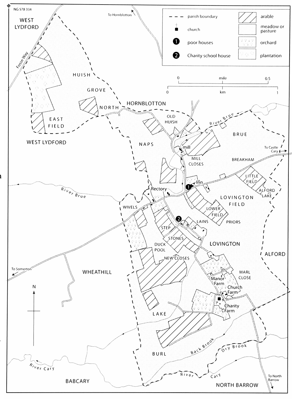
63. Lovington 1838
The parish in 1838, showing that most of it had been laid to grass and the village sprawled along roads for nearly a mile from the church and the farms round it north to the mill and beyond. The field called Step Stones may refer to unrecorded early quarrying.
THE ancient parish of Lovington, (fn. 1) in the shallow valley of the Brue just under 3.5 km. WSW. from Castle Cary church, is crossed by a busy road which joins Castle Cary with Somerton and by the meandering river which drove a mill from Domesday until the 20th century and which in the 18th century was noted for fine gudgeon, trout, roach, dace, and eels. (fn. 2) Most of the parish lies to the south of the road and river but reaches to the Fosse Way to the north, across an area called Huish, formerly common pasture. The land is mostly clay with some limestone but with gravel deposits both along the river towards Alford in the north-east and also from the parish church north-east to the railway, and there is a strip of alluvium on the southern boundary along the north side of the river Cary or its tributary the Dry Brook. (fn. 3) The highest ground is Wheat Hill, on the western boundary, which reaches just over 40 m.; most of the land lies between 25 m. and 30 m. In the 18th century it was described as 'rather flat and woody', presumably in hedgerows which abounded with fine elms, and there were rich pastures. (fn. 4) Elms still grew 'luxuriantly' in the 1830s. (fn. 5) The parish measured 828 a. before it absorbed Wheathill in 1933. (fn. 6) It now covers 446 ha. (1,151 a.). (fn. 7)
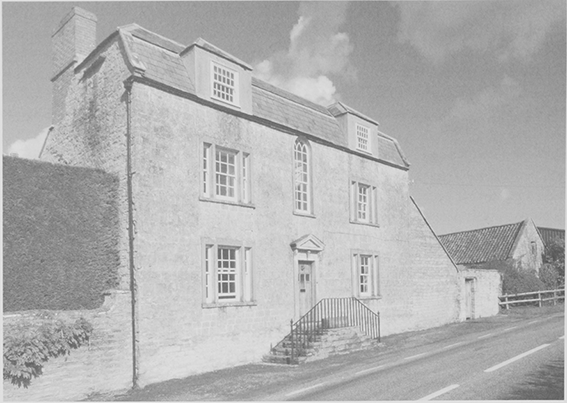
64. Brue Farm house was formerly an inn on the road to Castle Cary established by 1738 and known by 1788 as the Lovington inn. It closed in 1890 when the New Inn opened.
COMMUNICATIONS
The village lies on a north–south route across the Cary valley from North Barrow to Sparkford. The most important road, however, is that to Castle Cary, on which the Lovington Inn, now Brue Farm, was established before 1738. (fn. 8) The parish supported poor travellers along it in the later 17th century (fn. 9) when it was regarded as part of the route from London to Barnstaple. (fn. 10) Belief that it was earlier a pilgrim route to Glastonbury has given rise to the name Pilgrim's Way for houses beside the road and the Pilgrim's Rest for the inn. (fn. 11) The road was turnpiked in 1753 by the Langport, Somerton, and Castle Cary trust. Improvement was hampered by roadside cottages, possibly encroachments, in the west of the parish where a short section is too narrow for two-way traffic. A branch northwards to Hornblotton was included in a 1792 turnpike Act but may never have been adopted by the trust and was certainly abandoned by it by 1830. (fn. 12)
The railway from Castle Cary to Langport, completed in 1906, crosses the parish but the nearest station was at Keinton Mandeville. (fn. 13)
SETTLEMENT AND POPULATION
Lovington was recorded in the 11th century (fn. 14) but was clearly an earlier settlement deriving its name from a Saxon owner. (fn. 15) The village may have originally been around the church in the far south of the parish when north-south routes were more important. Later settlement gravitated towards the main east–west road with farms and cottages widely spread along the lane winding between the former arable fields, presumably the medieval east and west fields, and stretching from the church to the road. Other dwellings spread north along the lane beside the Brue to the mill. Despite modern development along those lanes there is still no nucleated settlement and the railway embankment divides the settlement around the church from the rest of the parish.
In the mid 17th century twenty-one houses were assessed for hearth tax, (fn. 16) while c. 1780 there were 23 houses, including 10 farmhouses. (fn. 17) The population numbered 120 in Richard Locke's survey (fn. 18) and 174 in 1801. It rose slowly over the next four decades to 239 and then for thirty years remained stable. (fn. 19) There were only 30 houses for 44 families in 1821 (fn. 20) but a total of 46 dwellings in 1896, of which 11 were classed as houses and 35 as cottages, 18 of which were not rated with gardens; (fn. 21) in 1929 the rating authority reckoned 41 houses of which 25 were cottages. Two houses were built on the main road by the rural district council in 1934 (fn. 22) and a further eight by 1947 replacing six demolished. (fn. 23) For much of the 20th century the population numbered around 150, rising between 1931 and 1951 when Wheathill became part of the civil parish but falling to 135 in 1971. It stood at 146 in 1991 and 189 in 2001. (fn. 24) In 1963 the civil parish including Wheathill had 53 dwellings of which three were bungalows. (fn. 25)
LANDOWNERSHIP
LOVINGTON MANOR
In 1066 the main estate at Lovington was in the hands of three tenants: Aelmer, Siric and Alsille, the last a woman. By 1086, the chief lord of the estate was Serlo de Burci, holder of several manors in Somerset and Devon, and part of Lovington was held under Serlo by Lambert. That arrangement also existed at Blagdon, which like Lovington and Wheathill was held by Aelmer in 1066. (fn. 26) By the early 14th century and almost certainly much earlier the whole was held as half a knight's fee (fn. 27) and later as a single manor.
Serlo de Burci's successors as chief lords were the descendants of his daughter Geva by her first husband Martin, all owners of the barony of Blagdon. Geva's son Robert fitzMartin (d. 1159) was followed in turn by his son William (d. 1209) and his grandson also William (d. c. 1216). Nicholas Martin died in 1282 and was followed by his grandson another William (d. 1324). William, son of the last, died childless in 1326. (fn. 28) The barony passed on the death of the last William Martin to James Audley (fn. 29) and passed with Blagdon manor in Richard II's reign to the Holand family. (fn. 30) In 1470 Lovington was held of Anne Holand (d. 1476), widow of the last duke of Exeter, and immediately after her death was held of her second husband, Sir Thomas St Leger. (fn. 31) In 1601 the manor was said to be held of the earl of Derby. (fn. 32)
The earliest recorded local tenant holding of Serlo's successors was Robert of Cary, also known as Robert of Lovington, who was lord of Lovington c. 1189. (fn. 33) In 1303 Roger of Arderne held the estate which was reckoned as ½ fee. (fn. 34) William of Arderne or William of Lovington held the fee in 1326 and 1341, (fn. 35) but by 1346 (fn. 36) the owner was Sir John St Lo who was dead by 1390. (fn. 37) By 1396 he had been succeeded by (Sir) Walter Rodney (fn. 38) who let it to Richard Shephurd, to be held of the abbot of St Mary Graces, London, as Rodney's trustee. (fn. 39) Rodney died in 1413 when his heir was his son John (died 1420). (fn. 40) Lovington evidently continued to be held by Shephurd until the time of Thomas Rodney, John's grandson, and at Thomas's death in 1470 it passed to his widow Isabel, later wife of William Paulet. Isabel died in 1476 when her son John was ten years old. (fn. 41) Sir John survived until 1526 and was succeeded by his grandson John, then a minor. (fn. 42) John himself died young in 1548 when his son was also a minor, although Lovington was settled on his two daughters, Elizabeth and Anne, to provide marriage portions. (fn. 43) Maurice Rodney, the heir, succeeded in 1561 (fn. 44) and died in 1588 leaving a son (Sir) George. (fn. 45)
George's heirs at his death by his own hand in 1601 were his sister Dorothy, wife of Rice or Rees Davis, and Francis Trenchard, son of his other sister Jane, although it seems possible that Sir John Rodney, a distant cousin, was also assigned a share of the manor as well as of other parts of Sir George's estate. (fn. 46) Francis, then a minor, succeeded to his share in 1607; (fn. 47) and Rice Davis in 1619 conveyed one third of the manor to Emanuel Hole, (fn. 48) whose father or brother was lessee of Lovington farm under the chapter of Wells from 1623. (fn. 49) Emanuel Hole the elder of Lovington claimed to hold the entire lordship and manor which he left in his will proved in 1649 to his son, also Emanuel; and the latter similarly left the manor to his son Abarrow when he died in 1695. (fn. 50) It seems to have passed to a second son, Emmanuel, by 1714 and in the following year to a Mr Ruddock. (fn. 51)
The property was thereafter divided into at least three parts, of which one comprised the site of the manor house, which was held by William Clarke before being settled on the marriage of his son James in 1727 as the portion of his wife Elizabeth. The estate continued to be held by members of the Clarke family, from 1745 mortgaged to Mrs Abigail Prowse of Berkley and later to her daughter-in-law Elizabeth, and in 1770 comprised Lovington farm, a holding of 124 a. and then in the occupation of Robert Clarke. The Clarke family's interests in Lovington seem to have been extinguished with the deaths of James Clarke c. 1789 and of Robert Clarke in 1790 and by the sale by James Clarke's trustees to John Cox. In 1819 Cox's holding was divided between Robert Leach of Martock and John Corry of Chilton Cantelo and both shares passed to William Purlewent of Shepton Mallet in 1830 (fn. 52) and 1837. (fn. 53)
The capital messuage or manor place referred to in 1727 was probably Lovington Farm, now Church Farm. (fn. 54) The house, opposite the church, is of 17th-century origin but mostly 18th-century.
A second part of the manor, but later described as the whole manor, passed by 1729 to Jane, wife of Nathaniel Webb of Roundhill in Wincanton. By 1744 she had been succeeded by her son, also Nathaniel, (fn. 55) who in or by 1762 sold to Cary Creed the younger of Castle Cary. (fn. 56) He died in 1775 and his father, also Cary Creed, later in the same year. (fn. 57) Creed the elder devised it jointly to William Pew (died 1784), a maltster, and John Tidcombe, a schoolmaster, both of Castle Cary. The estate was divided between them in 1776, each described as half the manor. (fn. 58)
Pew's share was sold in 1793 to Simon Pretor, a Sherborne (Dors.) banker, who in 1794 sold to Thomas Wake of North Barrow. In 1831 Wake's sons sold to William Purlewent, who had already bought land in Lovington, and Purlewent's estate and other lands in the parish were bought by the Revd John Gale Dalton Thring of Alford in 1844. (fn. 59)
John Tidcombe's share passed to James Tidcombe who in 1836 held 130 a. (fn. 60) and a James Tidcombe was said to have been lord of the manor until 1889 (fn. 61) or later. A Mrs Cox was recorded as lord by 1894 until 1906 or later and was followed by F. P. Pitman of Keinton Mandeville, (fn. 62) both probably because of their ownership of Manor farm. (fn. 63)
RECTORY AND CATHEDRAL ESTATE
About 1189 Robert of Cary gave Lovington church and 160 a. of land in the two fields of Lovington to Wells cathedral. (fn. 64) In 1291 a distinction was made between the church and the land. (fn. 65) Until c. 1430 the estate was held by cathedral canons (fn. 66) or for the common fund. (fn. 67) Thereafter until the mid 16th century it was held on lease, sometimes with a layman, by clerks who served as parochial chaplains. (fn. 68) From the later 16th century the estate was let to local farmers (fn. 69) when the distinction was again made between the 'manor or farm' and the rectory and parsonage, the latter presumably comprising only the glebe. From 1743 the lessees of the farm were the trustees of the clerical charity for the archdeaconry of Wells, (fn. 70) hence the name Charity farm for the estate. The lessees of the rectory in the 18th century were sometimes clergymen. (fn. 71) The estate was held by the Ecclesiastical Commissioners in 1939. (fn. 72)
The parsonage house was described in 1635 as having parlour, hall, and kitchen with rooms above and various farm buildings. (fn. 73) The thatched stone house called the Old Rectory on the Somerton–Castle Cary road may be that house. It has a cross-passage plan with timber partitions and a roof of three smoke blackened jointedcruck trusses formerly windbraced which suggests a 16thcentury origin; the rear parlour wing is 17th-century.
The Charity farmhouse was built in the late 17th century or early 18th, with a cross-passage plan and three rooms on each floor. The building is good quality and an 18th-century painted panel over a fireplace shows the house with a formal garden, perhaps appropriate to one of its clerical lessees, from which a garden wall with bee-boles and fine gatepiers survive. (fn. 74)
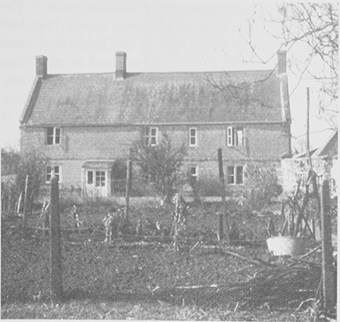
65. Charity Farmhouse, so named in the 18th century when the lessees of the farm were the trustees of a clerical charity for the archdeaconry of Wells.
OTHER ESTATES
In 1345 Robert Meysey held of Ralph Lovel by knight service a house and carucate of land, which he excluded from his gift to Stavordale priory, Wincanton. (fn. 75) It was possibly given to the priory later as in 1535 Taunton priory, which had incorporated Stavordale and its lands in 1533, held an annual rent of 17d. on land held from the Rodney family, which had originally been given to Stavordale priory. (fn. 76) By 1552 the property was described as two closes of land and pasture and was granted by the Crown, which had acquired the lands after the dissolution of Taunton priory, to Sir Edward Fiennes, Lord Clinton and Saye. (fn. 77) A year later the Crown granted the same to Edward Cooper, a clerk, and Valentine Fairweather, a London haberdasher. (fn. 78) Subsequent descent is uncertain but John Wallis of Lovington (d. 1614) held a messuage and 90 a. of the king's manor of East Greenwich, which passed to his son John, a minor. (fn. 79) Members of the Wallis family were still in the parish in the 1660s. (fn. 80)
John Mascoll had a house and land in Lovington c. 1500 (fn. 81) that possibly descended to John (fl. 1586) (fn. 82) and Walter Mascoll, of whom John Dampier of Lovington (d. 1589) held a house. (fn. 83) Dampier also held a freehold of the manor and in 1560 had bought a roofless tenement held of Alford manor by the Salmon family. The whole estate was held by his son John in 1589. (fn. 84)
John Cupper (d. 1619) had a house and two freehold parcels of land which passed to his son, also John. (fn. 85) By the 1650s John Cupper, probably son of the last, was in Barbados leaving his sick wife behind, (fn. 86) but members of the family held land in the parish until the early 18th century. (fn. 87) The freeholds appear to have been small and of little value by the late 17th century. (fn. 88)
ECONOMIC HISTORY
AGRICULTURE
Before 1066 Lovington had been held as three manors in parage. Together they gelded for six hides and there was land for eight ploughteams. The demesne of the single manor which was formed after the Conquest comprised just under three hides and was worked by two teams and two serfs. Just over two hides were cultivated by eight villeins and nine bordars with six teams. Lambert, possibly successor to one of the three pre-Conquest holders, had one hide with one team and three villeins, the latter sharing the land equally with their lord. The main holding had 40 a. of meadow and woodland measuring four by two furlongs; Lambert had 12 a. of meadow. Combined stock comprised 16 beasts, a riding horse, 13 swine, and 80 sheep. (fn. 89)
No further trace of Lambert's estate has been found unless it was the hide, defined as 160 a. and lying in two fields, which was granted to Wells cathedral c. 1189. (fn. 90) In 1341 the Wells estate included common pasture for three plough horses and 21 oxen, steers, cows, or heifers in Huish an area of pasture land north of the Brue. (fn. 91) In the mid 16th century Huish continued to be common pasture and its bushes and briars were a source for fuel. (fn. 92)
Exchanges of small pieces of land between tenants in Brufurlong, presumably the later Brue fields beside the river, and the west field in 1594 (fn. 93) suggest that piecemeal inclosure was under way and parcels of the east and west fields had been inclosed between 1635 and 1650; (fn. 94) some land was still located in furlongs in 1702. (fn. 95) Judging by the privy tithes payable to the rectors, farming was mixed. (fn. 96) The manor was valued at only £8 in 1601. (fn. 97) In the 1560s there had been three small freeholds including that of Sir Edward Waldegrave, (fn. 98) which was retained until the 18th century in the form of two small farms held as of Wheathill manor. (fn. 99) Another freehold belonged to the Milborne family. (fn. 100) The most substantial tenant farmers in the later 17th century were members of the Hole, Rush, and Clarke families: in the 1660s they occupied the only three-hearth houses in the parish (fn. 101) and by 1681 two Clarkes and three Holes were among the eight highest rated occupiers. (fn. 102)
The 18th to the 21st Century
Thomas Rush held the parsonage, later known as Old rectory (fn. 103) and Emmanuel Hole what was described as the Farm, later Charity farm. (fn. 104) In the earlier 18th century the Clarkes were the dominant farmers, (fn. 105) having a share in the divided manor (fn. 106) as well as being tenants of three separate holdings.
By the 1780s most of the land was under pasture although there were still scattered strips of arable in the former fields and wheat and beans were said to be good. (fn. 107) Twenty years later, in 1801 there were 90 a. under wheat, twice as much as usual, and there were 11 a. of peas, 9 a. of beans, and 7 a. of oats. Peas were described as very good, cereals good, but beans only 'middling'. (fn. 108) Forty families, out of 44, were engaged in agriculture in 1821. (fn. 109) In the 1830s the parish was recognized for its cows, sheep, and orchards. (fn. 110) In 1838 there were five small potato grounds. (fn. 111)
By 1838 just over 272 a. divided between four farms was in the possession of William Purlewent of Shepton Mallet. He held Church farm and Lovington inn as well as Mendip farm that has its farmhouse in Hornblotton. (fn. 112) In 1844 the Thrings of Alford, who had begun buying up land in the parish in 1809 and owned 90 a. by 1838, acquired the Purlewent estate. (fn. 113) The agricultural depression of the 1880s found Theodore Thring forced to reduce the rent of Church farm from £330 to £280 in 1885, which it remained in 1894 when John Huntley Thring let it to the former tenant's son. The landlord's bankruptcy caused sale of it and a farm in Alford in 1908 to Henry Matthew Ridley of Maperton. (fn. 114)
In 1838 the parish had been divided between grassland and arable (fn. 115) and still in the early 1870s children were kept from school for bird keeping, sheep keeping, milking, and apple and potato picking. (fn. 116) In the late 1830s there were seven farms centred in the parish. Two were over 100 a. and two more over 80 a.; a further two holdings comprised over 100 a. but were without dwellings. Lovington inn farm, 75 a. in 1838, (fn. 117) had by 1871 grown to 200 a. (fn. 118) Two of the substantial holdings were described as dairy and corn farms in 1875 but by 1889 all seven farms concentrated on dairying, although two also grew corn. (fn. 119) The tenancy agreement of 1882 for Church farm required a limit on arable sown with corn and on the amount of grass mown and included payment of barley to the landlord in return for the supply of seed sown for permanent grass. (fn. 120)
One farmer had a cousin as a farm pupil in 1901 and another had a labourer living in and a total of 22 agricultural workers was recorded. (fn. 121) In 1905 there were 821 a. of grass, nearly 55 a. of arable, and 22 a. of woodland. (fn. 122) Five farms were recorded in 1910 of which three were over 100 a., one owner occupied. Manor farm, a small farm of just over 55 a. reduced from 127 a. in 1910, had stalls for 35 cows in 1919. (fn. 123) Church farm in 1932 comprised nearly 148 a., having increased from 52 a. in 1910, and was described as a dairy or cheese-making holding with 'rich, sweet feeding' and included a cheese lift and a cider press (fn. 124) with which the detached building in front of the house might be associated. Brue farm also had a hoist to a cheese room with racking. (fn. 125) R. C. Washington in 1923 bred Gloucester Old Spots in the parish. (fn. 126) By 1929 there were six farms rated in the parish, led by Charity (160 a.), owned by the Ecclesiastical Commissioners in succession to Wells cathedral, and Brue (108 a.). Manor farm (57 a.), representing a small part of the manor not acquired by the Thrings, had belonged since 1919 to Somerset County Council. (fn. 127) In 1963 there were eight farms. (fn. 128) Several working farms remain in the parish and one dairy produces quality ice cream.
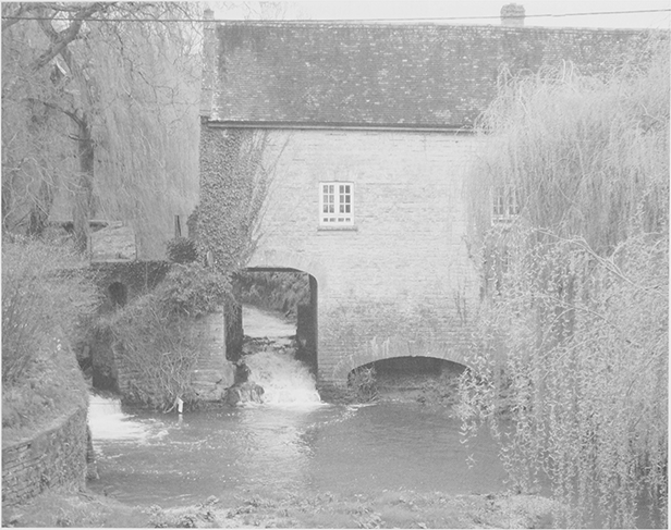
66. Lovington Mill. Lovington has probably had a mill since 1086. In 1776 it had both grist and fulling mills.
Farmhouses
Of the ten farmhouses recorded in 1780, several can still be identified, the oldest in the south of the village near the church. They include Manor farmhouse (later Lansdowne Cottage) which retains a 17th-century fragment, and two with some social pretensions: the late 17th-century Charity farmhouse, which belonged to the rectory estate; and Church farm, of 17th-century origin but mostly 18th-century. (fn. 129) Both Charity and Church farmhouses have 18th-century painted panels over a fireplace and garden features, a small pyramidal-roofed building in the case of Church farm. At Cedar farm a stone house of c. 1800 was faced in fashionable brick.
MILL
There was a mill at Lovington in 1086. (fn. 130) The miller in 1511 and 1565 was accused at the hundred court of taking too much toll. (fn. 131) There may have been two pairs of stones at the mill by 1697. (fn. 132) In 1776 the mill, from the following year owned by William Pew, was described as a grist and fulling mill and in 1795 both were sold to a miller. (fn. 133) John Thring bought the mill in 1809. (fn. 134) He may have been responsible for the well-built stone mill, which spans the mill leat and has a high wheel arch, warehouse, and attached three-storeyed three-bayed house, perhaps a successor to the thatched 18th-century Mill Close cottage which was much extended and altered in the 1920s. (fn. 135) When his son, the Revd J. G. D. Thring, let it in 1837 the miller was obliged to keep eel traps in repair and to allow the landlord a prior claim on eels valued at 4d. a lb. (fn. 136) William Meech, miller by 1851, had three employees there by 1861 when his wife kept a provision shop. (fn. 137) The Penny family operated the mill from the 1880s until 1939 or later. (fn. 138)
TRADES AND CRAFTS
In 1647 William Cooper, a clothier, was living in the parish and in the same year Thomas Rush, another clothier, acquired land there. (fn. 139) He or another of the same name, was lessee of the parsonage and also a clothier in 1675, (fn. 140) and among his contemporaries in the 1680s were a shearman and a fuller. (fn. 141) A linman was recorded in the middle of the 18th century. (fn. 142)
A smith's shop was in business on the Somerton–Castle Cary road by 1701, (fn. 143) a business which continued until 1906 or later. (fn. 144) In the earlier 19th century the usual village trades of carpenter, blacksmith, shoemaker, baker, and butcher were represented. There was a tanyard in 1838 (fn. 145) and a small brickyard near the mill by 1881. (fn. 146) A mason was in business by 1851, a builder by 1875 who in 1881 employed 15 men and had a small farm, and a veterinary surgeon by 1891. (fn. 147) Wheelwrights were in business until the 1930s. (fn. 148)
RETAIL TRADES AND SERVICES
A man was in breach of the assize of ale in 1512 (fn. 149) and there was a victualler in business in 1619. (fn. 150) The public house, known by 1788 as the Lovington inn and on the north side of the Somerton–Castle Cary road, had been established by 1738. (fn. 151) It was also the farmhouse of a 75a. farm by 1838, (fn. 152) but the buildings suggest that inn and farm were run from the site before that. The house has a polite front of c. 1800 with pedimented doorcase reached by a flight of steps, central arched window, a mansard roof and 19th-century rear additions, and a yard with extensive buildings to serve inn and farm. It ceased to be an inn in 1890 when its licence was transferred to an unnamed beershop, on the same road but further west and kept by the blacksmith. The latter was known as the New Inn by 1901 when it was kept by a butcher. (fn. 153) A restaurant was established there in 1957 and in the 1980s its name was changed to the Pilgrim's Rest. (fn. 154) The Cottage Brewing Company moved to Lovington from West Lydford in the late 1990s. (fn. 155)
A shop had been opened by 1839 (fn. 156) which by 1859 sold grocery and drapery. (fn. 157) A post office had also been opened by 1874 (fn. 158) and a second shop by 1875. (fn. 159) In 1901 the Old Rectory was occupied by a baker and confectioner who had a resident baker and also employed a boy. (fn. 160) David Corp's grocery and drapery business outlived most of the other trades in the earlier 20th century and in 1923 he was both village grocer and assistant overseer. (fn. 161) There was still a shop and a bakery in 1963 (fn. 162) but by 1979 the village was served only by a travelling shop. (fn. 163)
SOCIAL HISTORY
As late as 1901 and despite its proximity to Keinton Mandeville and Castle Cary, Lovington appears to have been a self-contained agricultural community with no industrial workers. The six 17th–18th century chest tombs in the churchyard and the good quality farmhouses of the same period indicate that farmers were prosperous. There were many very small cottages, since demolished, at least three of which had only two rooms and a further thirteen of which had three or four. They lay mainly on the main road and near the mill where a row of six tiny houses occupied by labourers was known as the Barracks. (fn. 164) In 1910 much cottage property was owned by F. P. Pitman owner of Manor farm. (fn. 165)
EDUCATION
A schoolmaster was reported in 1683 for teaching without licence and for absenting himself from church. (fn. 166) John Whitehead, who died in 1715, gave land in Foddington in Babcary to provide an income to school poor children. James Clark gave a house for a school house, which was used until c. 1823. From 1757 seven or eight children were taught to read and sew on weekdays. In 1798 it was said that numbers of children were declining leaving only infants 'uncapable of learning'. Coats were offered as an inducement to attend. In 1811 children were still being sent too young so it was decided to have school only on Sundays and clothing was given to the mistress and the children. About 1823 the school house was let to the overseers as a poorhouse, thus providing an increased salary for a mistress to teach both on weekdays and Sundays in an attached schoolroom rebuilt in 1829. About 1824 ten or twelve children attended regularly and were taught to read, say prayers, and repeat the Church catechism; girls were taught to knit and sew. (fn. 167)
In 1835 there were 19 children attending on weekdays and 18 on Sundays. (fn. 168) A new schoolroom was built in the 1840s (fn. 169) for what was described as a medial or union school to serve Lovington, Alford, and Hornblotton. By 1846 pupils paid either 6d. or 1½d. and were taught by a master of 'questionable attainments' and a female monitor who was 'intelligent and informed'. The children paying the smaller fee were neglected. The school was united with the National Society and taught 44 children who attended on Sundays only and 32 who went on weekdays and Sundays. (fn. 170) The charity capital was vested in the Charity Commissioners before 1870. (fn. 171) A night school was opened in 1872 but attendance was poor because of farming demands and children were described as 'extremely dull and very backward'. (fn. 172) In 1903 there were 53 children on the books and two teachers shared a single classroom. (fn. 173) Numbers fell over the next three decades and from 1939 only infants and juniors were taken. By 1965 the school had adopted voluntary controlled status and after 1985 its numbers expanded. (fn. 174) In 1997, with 84 pupils, four teachers and four classroom assistants, it was adjudged excellent. (fn. 175) The school occupied the 1840s building and additional temporary buildings.
CHARITIES FOR THE POOR
From 1694 the parish poor were given 'interest money' on gifts made under the wills of John Jennings (d. by 1694) and Richard Cooper (d. 1705). (fn. 176) Those payments probably ceased in the 1730s, to be replaced by the gift of Thomas Wallis, first mentioned in 1707, which was a rent charge on land producing 12s. payable to the second poor on Christmas Day. (fn. 177) About 1824 the sum was distributed to 12 labourers. (fn. 178) The rent charge was redeemed and invested in consols in 1870 and a sum of 2s. 6d. was received quarterly until 1940 or later. (fn. 179) By the 1920s distributions were not made every year and in 1927 accumulated cash was spent partly on a meal for pensioners. (fn. 180) A bequest of £40 from Miss Mary E. Jeffreys was invested in 1910 and produced interest of 24s. 4d. in 1940. (fn. 181) The only charity registered in the parish in 1994 was the Parent Teacher Association of the village school. (fn. 182)
COMMUNITY LIFE
In the late 18th century a revel was held on St James' Day (25 July) (fn. 183) and a friendly and benefit society was begun in 1830. (fn. 184) Still in the 1870s children went begging around the parish by custom on St Thomas's Day (21 Dec.). (fn. 185) By 1947 there were clubs for cricket and youth tennis, a branch of the county library at the school, and branches of the Mothers' Union and the Women's Institute (meeting in the chapel schoolroom). In 1950 the library was still operating at the school, but there was also a private circulating library and a youth club. By 1979 there was a mobile library and the school hall was used for social gatherings. (fn. 186) In 1997 the manager of Lovington, New Mexico, USA, visited the village and gave it the freedom of his city. (fn. 187)
LOCAL GOVERNMENT
Lovington constituted a single tithing which included Alford by the earlier 14th century and accounts of the tithingman for 1681–3 record contributions to the militia, to county rates, and to travellers including three companies of cripples. (fn. 188)
MANORIAL ADMINISTRATION
The owner of Lovington manor claimed view of frankpledge in 1697 (fn. 189) and the chapter of Wells as owners of the parsonage held both temporal and spiritual courts in the 17th century, their tenant having to provide two meals at each session for the steward and his company as well as food for their horses. (fn. 190) Stocks still survived in 1946 (fn. 191) and pounds were mentioned beside the churchyard in 1768 and near the inn in 1919. (fn. 192)
The dean and chapter of Wells as owners of the rectory and parsonage exercised a peculiar jurisdiction in the parish until 1845 under an Official or Registrar (fn. 193) which included the right of probate by 1547–8. (fn. 194) Annual visitations, in the later 17th century conducted by one of the canons alternately at Lovington and South Barrow and held in the parish church, sometimes adjourned in the afternoon to a neighbouring house, were concerned with the fabric and ornaments of the church, absenteeism, and matrimonial and probate business. (fn. 195) The last will was proved in the court in 1840. (fn. 196)
PAROCHIAL ADMINISTRATION
Churchwardens and sidesmen made presentments at visitations in the late 17th century. (fn. 197) Churchwardens, overseers, and waywardens, usually one of each and sometimes holding more than one office at a time, were chosen in rotation according to holdings but were nominally appointed by a group of up to six 'head payers' who by 1745 were described as a vestry. The vestry in 1838 comprised only the minister, a warden, and two overseers. In 1748 the office of overseer was exercised by a deputy. (fn. 198) A parish clerk, probably nominated in the visitation court, (fn. 199) was after 1740 paid a guinea a year on Easter Monday rather than himself collecting 4d. from every housekeeper on St Thomas's Day. (fn. 200) A parish hayward was nominated in 1856 and a parish constable from 1863. (fn. 201) There was a resident policeman by 1861. (fn. 202)
In the later 17th century the overseers provided cash, clothing, house rent, and board and lodging for paupers and among extraordinary payments settled doctors' bills and sent a man to Ireland with a letter to the brothers of a female pauper. By 1740 the poor were living in the school house (fn. 203) and they were still there in the mid 1820s. (fn. 204) A separate building was acquired before 1838 when it was sold. (fn. 205) The cost of poor relief had been reduced under the Poor Law Amendment Act from £193 to c. £89 by 1840 (fn. 206) after the parish had become part of the Wincanton poorlaw union in 1835. A parish meeting was formed in 1894. In 1933 Wheathill became part of the civil parish and in 1981 both became part of Cary Moor civil parish. (fn. 207)
RELIGIOUS HISTORY
CHURCH
Robert of Cary, lord of Lovington, about 1189 gave the church, which is dedicated to St Thomas Becket and may have been founded by Robert, to Wells cathedral. (fn. 208) Its income was normally paid to the chapter's common fund (fn. 209) but in 1319 it still had not been formally appropriated. (fn. 210) The church was served by curates, appointed by the chapter until the establishment of a perpetual curacy in 1721. By the 1860s it was regarded as a vicarage. (fn. 211) From 1919 the incumbent of Lovington also held North and South Barrow (fn. 212) but lived at Lovington until 1931 or later and from 1939 at North Barrow. (fn. 213) In 1968 Lovington and the Barrows were joined with other parishes including North and South Cadbury, Compton Pauncefoot, Maperton, and Sutton Montis, (fn. 214) but in 1977 were created a united benefice together with Alford, Babcary, and Hornblotton under the title of The Six Pilgrims. (fn. 215)
Advowson
The chapter of Wells appointed curates from the 13th century and now has the second turn of patronage in every four turns to the united benefice. The other turns are held by the diocesan board of patronage, the bishop and the Church Society. (fn. 216)
Income and Endowment
In 1291 the church was valued at £5 but only £3 10s. in 1535. (fn. 217) Later the chapter paid its curates from the profits of the rectory, until an endowment in 1721 established the living as a stipendiary or perpetual curacy, which from 1756 was supplemented by the lessee of the cathedral estate in the sum of £10. (fn. 218) Endowments between 1782 and 1831 brought the value of the living to £76 with 24 a. of glebe. (fn. 219) The living was augmented again in 1859. (fn. 220) In 1882 a grant from the Common Fund produced a stipend of £122. (fn. 221)
There was a substantial parsonage house, occasionally lived in by clergy serving the parish who had leased the rectory. There was, however, no house for the curates who provided pastoral care most of the time. In 1623 the lessee of the farm was required to find a site for a curate's house, (fn. 222) a request repeated in 1661 but evidently not acted upon. (fn. 223) A plain gabled TudorGothic style house was built for the curate in 1860–1 to the design of H. J. Paull of Cardiff (fn. 224) on a site on the main road given by the Revd J. G. D. Thring. Known as the Parsonage House it was sold in 1951. (fn. 225)
Pastoral Care and Parish Life
In 1241 the cathedral gave the income of Lovington, together with Mudford, to a priest for life as compensation for the loss of a benefice elsewhere, but without any obligation to serve the cure. Nevertheless, it undertook to repair the chancel and supply books and ornaments. (fn. 226) By 1430 until 1450 or later John Love, clerk, described as parochial chaplain in 1450, was also lessee of the cathedral estate. (fn. 227) John Seward, resident chaplain in 1463, was also lessee by 1461 until 1474 or later, and three other clerks until the beginning of the 16th century may also have served the parish as well as holding the cathedral estate. (fn. 228) In 1510 one of the cathedral canons was paid to preach four times a year at Lovington and Barrow. (fn. 229)
By 1542 until 1560 or a little later Thomas Cherde or Shepherd, lessee of the rectory, was resident priest, possibly in the rectory house. (fn. 230) Curates were paid sums between £5 and £9 a year during the next decade, but by whom is not clear, (fn. 231) though the cathedral paid half the cost of the provision of the Paraphrases of Erasmus for the parish. (fn. 232) The farmer of the cathedral estate in 1542 was to support all the charges of the church including the fabric of the chancel (fn. 233) and he was held responsible for the lack of monthly sermons in 1606. (fn. 234)
In 1634 the church walls were painted with sentences of scripture, which were reported defective for want of a workman. (fn. 235) A pewter flagon also dates from this period. The church was raided during the Civil War, probably in 1643 when the New Model Army was in the district, suffering damage to furnishings and theft of surplice and plate, including the chalice, not replaced until the 18th century. (fn. 236) The present cup and cover are thought to be of the early 18th century, a pewter flagon of the earlier 17th century, and pewter candlesticks of the 18th century. (fn. 237) Sums spent on a pulpit in 1718 and on making and painting boards with the commandments and the Lord's Prayer in 1766 (fn. 238) are some indication of the vigour of church life in the 18th century. By about 1780 the interior, although judged to be 'dark and gloomy', included a singers' gallery, its front formed with wainscot and bearing a painting of David with his harp. (fn. 239)
The lack of a house and small stipend encouraged absenteeism and plurality and Lovington was usually held with other parishes. J. C. Palmer, curate from 1810, lived at Compton Pauncefoot and also served Sutton Montis, (fn. 240) but in 1815 employed the rector of Wheathill to serve Lovington on alternate Sundays. (fn. 241) Twelve years later the perpetual curate of Lovington lived at his rectory house at Sutton Montis and employed Thomas Woodforde of Ansford to serve both Lovington and South Barrow. (fn. 242) From 1846 the vicar of Castle Cary held the parish but employed a curate, sometimes exclusively for Lovington. (fn. 243)
On Census Sunday 1851 there was an afternoon congregation of 63. (fn. 244) In 1859 the parish agreed to pay its priest 12s. to provide the elements for the holy communion. (fn. 245) A parish rate paid for a new tower in 1861 but the replacement of the nave in 1862–3 was met by a voluntary rate, the incumbent, the Revd Peter Moore, finding the remainder 'be it more or less'. (fn. 246) By 1864 the renewed church had monthly celebrations of holy communion, (fn. 247) and by 1870 there were two Sunday services one with a sermon in the afternoon. (fn. 248) In 1876 services were held at 11 am. and 6.30 pm each with a sermon except on the first Sunday in the month when communion took its place in the morning. (fn. 249) Easter communicants rose in number from 13 in 1905 to 30 in 1960. (fn. 250) In 2002 there were monthly services.
Church Building
The medieval church comprised chancel, nave with a south porch in the centre of its southern wall, and a west tower, all in Perpendicular style. A Mr Francis tendered for rebuilding the tower in 1861 and in 1862–3 the nave and porch were demolished and rebuilt to the same design with a the north aisle, vestry, and tower turret added by the architects, Paull and Robinson of Cardiff. (fn. 251) A piscina and aumbry retained in the south wall of the rebuilt church by the chancel arch were probably for a subsidiary altar. Another aumbry, perhaps 16th-century, in the chancel has naive carvings, and a door carved with the date 1842. (fn. 252) Also reused were some old bench ends carved with tracery and stylized foliage. The three bells comprise one from the Dorset foundry by John Louker of the late 15th century and other of 1625 by Robert Austen and of 1683 by Thomas Purdue. (fn. 253)
NONCONFORMITY
In 1634 three people were accused of not attending church. One of them, Jane Gaylard, (fn. 254) was probably related to John Gaylard, a Quaker, John and his wife Sara were reported to be absent from church between 1666 and 1685 and John or a namesake was presented as not lawfully married to his wife Elinor in 1687. In 1691 a man refused to pay church rates. (fn. 255) A couple from Lovington were clandestinely married by a nonconformist minister at Cricket St Thomas. (fn. 256)
Methodists
Methodism had probably been introduced by 1827 when a building was licensed for use. (fn. 257) A private house was licensed in 1841 for an unspecified congregation, again probably Methodist, (fn. 258) and in 1851 there were two Methodist congregations, both using shared buildings, both describing themselves as Wesleyan, and both served by the same minister from Castle Cary. The larger congregation, formed in the previous year, numbered 70 in the evening of Census Sunday; the smaller, in a private house, had a morning congregation of 30 and an evening one of 35. (fn. 259) Both congregations were licensed in 1851. (fn. 260) They evidently soon merged but continued only until 1858. (fn. 261) A chapel had been built by 1875 (fn. 262) which by 1886 belonged to the Bible Christians and was named Providence. (fn. 263) It was part of the Somerton and Castle Cary Bible Christian circuit and was rebuilt plainly in stone to seat 80 with an adjoining school in 1896 and opened in the following year. (fn. 264) It subsequently became part of the United Methodist church (fn. 265) and was described as Wesleyan in 1947. (fn. 266) Services were held on Sunday evenings and on Tuesday evenings in 1935 and twice on Sundays and Friday evenings in 1951, on Sunday and Tuesday evenings in 1964; the last services were held in 1965 and the building was up for sale in 1967. (fn. 267) Two memorials from the chapel, now a private house, were placed in the parish church in 1972. (fn. 268)