A History of the County of Somerset: Volume 10. Originally published by Boydell & Brewer for Victoria County History, Woodbridge, 2010.
This free content was digitised by double rekeying. All rights reserved.
'West Lydford', in A History of the County of Somerset: Volume 10, ed. Mary Siraut (Woodbridge, 2010), British History Online https://www.british-history.ac.uk/vch/som/vol10/pp189-211 [accessed 30 April 2025].
'West Lydford', in A History of the County of Somerset: Volume 10. Edited by Mary Siraut (Woodbridge, 2010), British History Online, accessed April 30, 2025, https://www.british-history.ac.uk/vch/som/vol10/pp189-211.
"West Lydford". A History of the County of Somerset: Volume 10. Ed. Mary Siraut (Woodbridge, 2010), British History Online. Web. 30 April 2025. https://www.british-history.ac.uk/vch/som/vol10/pp189-211.
In this section
WEST LYDFORD
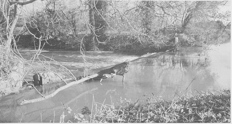
67. A weir on the river Brue is part of a complex system built to control the flow of water into the millstream, which crossed the parish, powering both Lydford mill and King a Mill.
THE PARISH lay mainly west of the Fosse Way between Shepton Mallet and Ilchester. It is crossed from east to west by the river Brue, which divided the church to the north from the village to the south. (fn. 1) The irregularly-shaped parish is bounded on the north and west by streams, on the south-west by Babcary Lane, and on the south-east by the Fosse. The Brue and a stream, probably an earlier course of the river, form the southern boundary of Eastfield, although the divergence of the main river and parish boundary indicates the natural course of the river has been altered. At its greatest extent the parish measured 4.5 km. north to south and 4 km. east to west. From a broad east west alluvial valley below 20m (66 ft) through which the river runs, the land rises gently north toward Lydford Green and more steeply south over Lower Lias clay to 54 m. (177 ft) on the Somerton road but only to 38 m. (125 ft) on the southern boundary. The north of the parish reaches 42 m. (138 ft) on the Fosse. A stream flows west to join the Southwood brook or Emmett, (fn. 2) below 23 m. (75 ft). Another runs south from Lydford along the Fosse to the Brue. (fn. 3) Four Foot, a detached part of East Lydford north of the park, with four houses, land, and wood, was transferred to West Lydford in 1884 (fn. 4) increasing the parish to 1,897 a. (fn. 5) The civil parish was merged with that of East Lydford in 1933. (fn. 6)
COMMUNICATIONS
The Fosse Way from Ilchester largely follows its Roman course along the eastern boundary and was turnpiked by the Ilchester trust in 1753. (fn. 7) It is crossed by the Castle CarySomerton road, formerly a major route, turnpiked by the Langport, Somerton, and Castle Cary trust in 1753. (fn. 8) Both roads were extensively encroached on by 1827. (fn. 9) There were two gates with tollhouses on the Fosse by 1851. (fn. 10)
Lydford, variously said to mean the broad ford or the ford over the torrent, (fn. 11) is likely to have been a ford taking the Fosse Way over the Brue, the names of the parishes east and west of the Fosse being derived from it. The ford was replaced by Lydford or Bridgefoot bridge, (fn. 12) probably between 1242 when the Lydford chaplain's servant on horseback was drowned in the Brue (fn. 13) and 1327 when the name Walter de Brugge (Bridger) occurs in West Lydford. (fn. 14) In 1632 the Fosse and village bridges were ancient bridges maintained by the county, (fn. 15) which declined to repair an unidentified third bridge claimed as a county bridge in 1683. (fn. 16) Before 1851 the bridge carrying High Street over the millstream, a single-arched bridge with wooden rails, was substantially repaired as a county bridge, probably because the stream was the course of the Brue when the first bridge was built. (fn. 17) High Bridge, probably built in the 1840s, was dropped from the county list in 1874 but restored in 1929 although it carried no through route. (fn. 18)
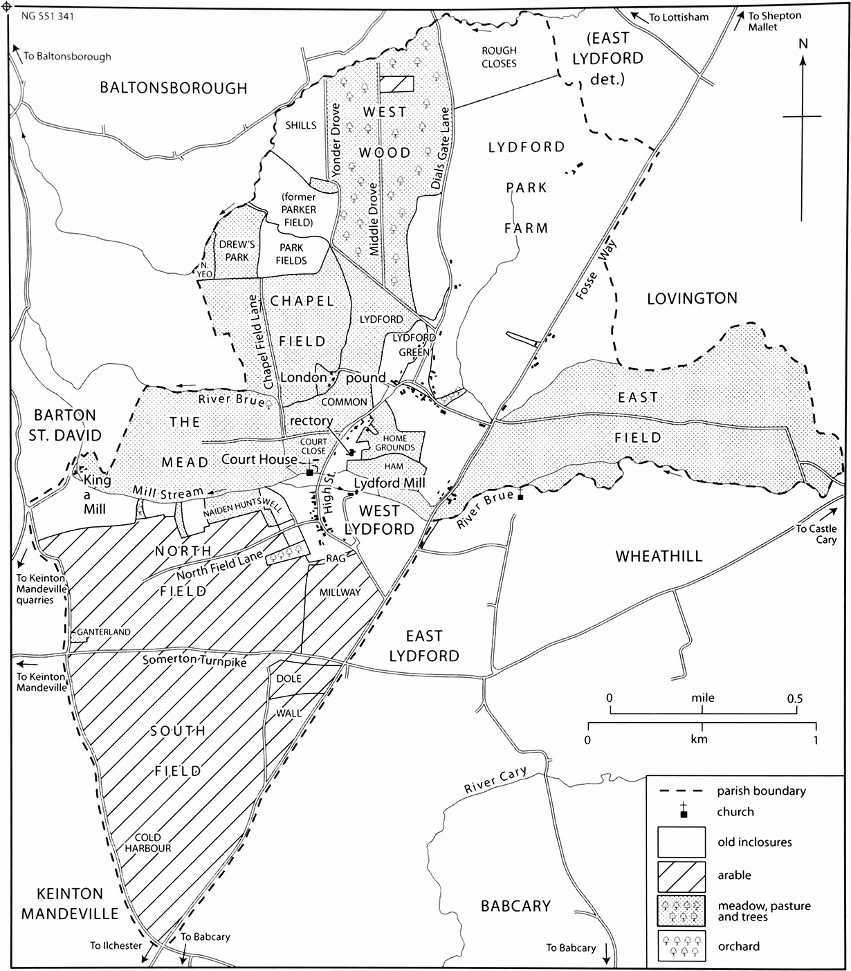
68. West Lydford 1827
The parish on the eve of inclosure. Two arable fields lay south of the village. The north field had already been reduced by inclosures. The park fields probably represent the medieval Trivets Park.
Despite regular repairs, recorded as early as 1733, (fn. 19) the Fosse bridge was demolished in 1820 and a replacement built slightly further upstream with a realigned roadway. The new bridge, costing 248, was designed by G. A. Underwood and had a single arch with a 25-ft span. (fn. 20) The five-arched village bridge, also repaired in 1733, was probably built in the 17th century and built following changes to the course of the river. It 1846 it was restored by Richard Carver who rebuilt the abutments and four cutwaters, repaired the arches, and built blue lias parapets with five segmented floodwater arches. (fn. 21)
From the Fosse Way a road to the mill and village, partly known as High Street, crossed the Brue by a ford later replaced by a bridge, and divided at the Fair Place, named after the important fair formerly held there. (fn. 22) The eastern branch, East Street in 1841, (fn. 23) crossed the Fosse to become Eastfield Lane as far as Lovington and the northern route, Dials Gate Lane, continued to Lottisham across the bridge called Dial's Gate in 1827. (fn. 24) Grazing on the road belonged to the manor. A lane from Lydford common, skirting the east side of Drew's Park, to Southwood in Baltonsborough was a dead end by 1827 when all lanes giving access to fields were classed as private roads. (fn. 25) The Wale in South field may be part of a way across the fields (fn. 26) and Chapel Field Lane was also called a wale or wall. Possibly both were raised on banks, which formerly divided the fields. (fn. 27) Cottons and Babcary Lanes, possibly the 17th-century Hurbrook's Way, followed the south-western boundary from King A Mill to the Fosse at Westover gate. (fn. 28)
In 1901 a civil engineer and his chainman lived at West Lydford, (fn. 29) possibly surveying the Great Western Railway's projected line across the south of the parish from Castle Cary, opened in 1905. (fn. 30) The company acquired land before 1903 and rented a cottage as a railway office. (fn. 31)
SETTLEMENT AND POPULATION
The church and rectory on the north bank of the Brue may represent early settlement, also reflected in the parish room behind the church, which has a late medieval roof. The building of mills and alterations to straighten the river to create a greater head of water possibly increased the risk of flooding. The compact village, either side of the road from the Fosse to the church, grew up by the river and was bounded by arable land on the gently sloping valley sides and until the late 13th century by extensive woodland in the north of the parish. West Lydford had three large open arable fields; West (later North) and South fields in the south between the Fosse and the millstream and separated by the Somerton road, and Chapel field in the north-west between Lydford common and the Baltonsborough boundary. (fn. 32) The medieval Parkerfield, (fn. 33) also Portch (fn. 34) or Port field, probably lay north of Chapel field where there are traces of ridge and furrow and fields called Park field. (fn. 35) Open arable survived north of Lydford park in 1556, (fn. 36) known as Rough closes in 1827. (fn. 37) Sillmead and Mead, common meadow, lay on the alluvium between the Brue and the millstream, and North Yowe or Park meadow lay beside Southwood brook. (fn. 38) The common or green east of Chapel field, with Westwood to the north, provided common grazing. East field may always have been pasture and there was pasture called North field in the early 15th century. Lydford park occupied the area between Westwood and the Fosse and a smaller park lay west of Westwood. (fn. 39)
Older houses survive amidst late 20th-century infilling and farm conversions. (fn. 40) Houses were built around the triangular Lydford Green, now Fair Place, possibly by 1606 when its boundary banks had been breached for wain access, (fn. 41) to house an increasing population; thirty-one men were mustered in 1539 (fn. 42) and 105 people paid poll tax or subsidy in 1641. (fn. 43) Roadside cottages north of the rectory had been demolished before 1886 except for one retained by the rector. (fn. 44) London House was built probably in the 1850s on the site of a dilapidated squatter settlement on the edge of the common, (fn. 45) named London, signifying remoteness, from the early 18th century. (fn. 46)
In 1791 there were said to be 71 houses, including 40 farms, two mills, and two public houses, mainly of Keinton stone, chipped smooth, and thatched, and most forming a 'decent' street. (fn. 47) Although the population rose sharply from 313 in 1801 to 402 in 1811 and to 437 in 1821, there were only 57 houses in 1801 and 64 in 1821. (fn. 48) Following inclosure in 1827 outlying houses were built (fn. 49) including Millway or Chapel Lane (fn. 50) off the Fosse where houses were built before 1840. (fn. 51) Some wayside cottages were later abandoned although several survive along the Fosse. (fn. 52) The population fell to 357 in 1831 and reached 385 in 1851, (fn. 53) before declining in every decade to 237 in 1901. It was 243 in 1931. (fn. 54) West Lydford probably accounted for half the population of the combined parish, which numbered 444 in 1991. (fn. 55)
BUILDINGS
The secular buildings of West Lydford form three distinct groups, two of which occupy the higher ground to the north and south of the river Brue with a third, including the parish church, parish hall and rectory, between them on lower lying land prone to flooding. North of river, in a clearing, which probably formed part of Lydford Wood, the buildings of Lydford Green (later Lydford Fair Place) were built around a roughly triangular parcel of open land, bisected by Dials Gate Lane, which runs north-east to Lottisham. Separated from the village centre to the south by the common, Lydford Fair Place appears to have developed as a more nucleated settlement in line with an increase in population after 1600. Most of the buildings appear to date from the 17th century, built to a cross-passage plan over one and a half or two storeys, although many have been much altered. To the south of the river, the settlement is linear along High Street, where 19th and 20th-century houses are interspersed with larger farmhouses. Keinton blue lias stone was widely used in the parish, not only for buildings but also the raised pavement in the High Street, the dry stone walls of the better quality houses and the slab fencing still surviving around cottage gardens especially in Fair Place. Double-Roman tiles have replaced thatch, evidenced by the surviving coped gables on many of the houses.
Farmsteads and Houses
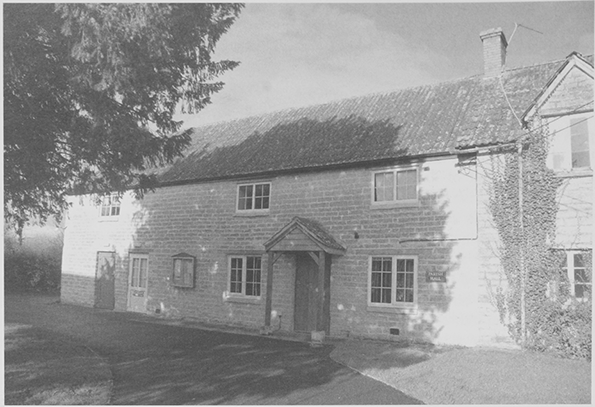
High Street On the west side south of the mill stream at Bridge Farm the core of the farmhouse may be early 16th-century; a cruck beam re-used in creating the attic may indicate a medieval predecessor. The date IE 1637 inscribed on a stone in the back of a fireplace suggests the rest was built in the early 17th century. It has three bays, two storeys and an attic, and a crosspassage plan. The windows to the principal eastern elevation and south gable end have ovolo moulded stone mullions; the north gable end has been extensively rebuilt. The farmhouse was extended and altered during the 19th century, including the addition of three brick stacks. (fn. 56) To the south-west, the farmyard has an interesting T-plan complex of 19th-century buildings, notably a seven-bay, 92-ft long threshing barn, now a store, which forms the eastwest range. Built of the same stone as the farmhouse, the north frontage has a big gabled porch in traditional style and neo-medieval loops for ventilation. (fn. 57)
Further south at the junction with North Field Lane is Higher House. The original farmhouse of three bays was built in the early to mid 18th century with a thatched roof. (fn. 58) Shortly afterwards the house was extended to the rear by a two-bayed wing at right angles, to form an asymmetrical T, and a bay was added north of the main front. (fn. 59) The original casement windows survive on the first floor, the ground floor ones having been replaced by 19th-century sashes. High Street farmhouse, set back at the far south end of the village, was built for the steward of Lord Roundway's estate before 1827. It is square and Tudor Gothic in style with a hipped and gabled slate roof. (fn. 60) The mullioned windows contain cast-iron casements. Barberry, a much altered house likely to date from the early 17th century lies opposite High Street farmhouse on the eastern side. (fn. 61) After 1827, the northern gable wall was demolished and two bays were added. (fn. 62) The rebuilt gable follows c. 55 degree angle created by the property's boundary and the intersection of the curve of High Street. Between Barberry to the south and the old school house to the north 20th-century infilling includes two detached and two pairs of semi-detached houses, built between the Second World War and 1974 of Keinton stone and mimicking the local vernacular style. (fn. 63)
Lydford Fair Place Adjacent to the Lord's pound is West Lydford's oldest house, Fair View, a house with a cross-passage plan, originally of one and a half storeys and from the evidence of the framed ceiling beams built in the late 16th century; it then would have comprised a hall, cross-passage and kitchen. (fn. 64) The fireplace and northern stack appear to have been added in the late 17th century. (fn. 65) On both gable ends the scar of a lower and more steeply pitched roof line shows that walls have been raised to form a full second storey and that the house was once thatched. The changes to the roof and the height of the first-floor windows and the refenestration of the house date from the 19th century.
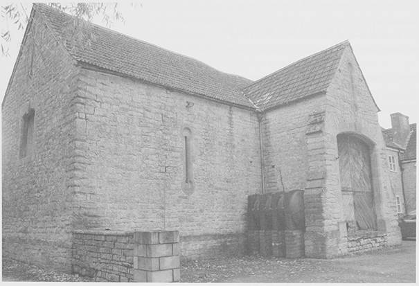
69. A 19th-century medieval-style barn at Bridge farm, West Lydford, no longer a working farm and with much of its farmyard converted to residential use.
Further north along the western edge of the Fair Place, Hill House and Sunny View are farmhouses probably of the late 17th century. In 1827 they were simple rectangular buildings of similar size; the original two bay crosspassage plan is clearly discernable at Sunny View. (fn. 66) By 1886 both houses had been extended, Hill House by one bay and Sunny View by one at each end. (fn. 67) By 1930, Sunny View's northern extension had been removed and its footprint repeated by a single storeyed extension erected by 1974. (fn. 68) The house was probably rendered then, and a west wing had been added at right angles to Hill House. Fosse farmhouse was built in 1968 on the site of a modest, probably 17th-century house, which stood there by 1827. (fn. 69) It had been substantially extended by 1886 and a large complex of agricultural buildings was added to the north before 1974. (fn. 70)
North of Fosse farm a row of three cottages, called Westwood Villas, originated as a single building subdivided after 1827 when the roof was raised and dormer windows and brick stacks were inserted. The name suggests the cottages provided accommodation for agricultural labourers of Westwood farm, a farmstead south of Fosse farm for which an L-plan range of agricultural buildings had been constructed round the farmyard by 1886. (fn. 71)
The village street turns through 90 degrees to the south of the Fair Place to rejoin the Fosse Way and in this area is a concentration of late 17th to mid 18th century buildings. Most of them were farmhouses constructed of coursed blue lias with double-Roman tile roofs, to a cross-passage plan and usually with two storeys and four bays. The 17th-century Grange farmhouse and Clover Cottage are both examples of this type, as are the slightly later and much altered Fairplace and Eastfield farmhouses, east of Clover Cottage. Grange farmhouse retains a stone mullioned window on the ground floor level, a rare survival in West Lydford. (fn. 72) A single-storeyed wing to the west of Grange farmhouse and a range of agricultural buildings to its east had been added by 1886. (fn. 73) Coombe Place and Coombe House, formerly a beerhouse, (fn. 74) are adjoining houses of the mid and early 18th century respectively, and have stone voussoirs over the main openings. Eastfield farmhouse may date from the 16th century and have been mostly rebuilt in the 17th possibly as two dwellings, its form in the early 20th century. (fn. 75)
The Fosse One large isolated farmstead, Bridgefoot House, is located on the Fosse, just north of the river Brue. Extensively altered, it has a cross-passage plan, which suggests that it too dates from the end of the 17th century. The original windows were replaced with timber casements and the roof was raised both during the 19th century. (fn. 76) The farmstead is provided with water via a channel diverted from the Brue close to Lydford Mill.
LANDOWNERSHIP
WEST LYDFORD MANOR
Brictric held West Lydford under the king in 1066 and by 1086 had been succeeded by his son Aelfric. (fn. 77) In the mid 12th century the estate belonged to Robert de Boleville or Bonville, possibly in right of his wife Beatrice. (fn. 78) By 1182 Robert had been succeeded by his brother John (d. 1199) (fn. 79) who held West Lydford of the honor of Gloucester. (fn. 80) His heir, also John de Bonville, held it for two fees in 1212. (fn. 81) The fees were claimed by that honor in 1386 (fn. 82) but following the attainder of Thomas Despencer in 1400 and the death of his mother who held them in dower c. 1414 the manor was held of the king in chief. (fn. 83)
John Bonville (fl. 1249), (fn. 84) was dead by 1253 (fn. 85) when his daughter and heir Isobel was the second wife of Nicholas FitzMartin. (fn. 86) Nicholas held the two fees in 1263. (fn. 87) In 1280 Nicholas said he held the manor, the inheritance of John Peverel (fl. 126280), son of Isabel by a former husband Hugh Peverel, for life. (fn. 88) John left a widow Amy (fl. 1286) and a daughter Amy (fl. 1280), wife of Robert Martin, Nicholas's second son by his first wife who lived at West Lydford. (fn. 89) Although Amy had issue and Isobel had sons by Nicholas (d. 1282), (fn. 90) the manor was successfully claimed by William Martin, son of Nicholas (d. 1260), eldest son of Nicholas by his first wife. (fn. 91) William granted it in 12823 to his wife Eleanor de Mohun for life for an annuity of 200. (fn. 92) William Martin held West Lydford alone in 1314 (fn. 93) but in 1316 he held jointly with Thomas Trivet. (fn. 94) William (d. 1324) was succeeded by his second (fn. 95) son William (d. s.p. 1326) but one third of the manor was held by John or Joan Trivet. (fn. 96) There is no further record of Trivet ownership although they gave their name to a park. The younger William Martin's widow Margaret (fl. 1359), who married Robert de Watvill, obtained the advowson as her dower in 1326. Two thirds of the manor, with reversion of the rest, went to James Audley, grandson and coheir with his aunt Eleanor, of the elder William, under a partition. (fn. 97)
In 1337 James and his wife Joan granted the manor to Philip de Columbers (d. 1341) and Eleanor (d. s.p. 1343) presumably for lives for a rose rent. (fn. 98) By 1346 James Audley had let the manor to Humphrey Tromyn for life. (fn. 99) In 1353 James settled the reversion after his death on the king. The settlement was repeated in 1354, when the king was a party, and in 1356. (fn. 100) After James died in 1386 (fn. 101) the king gave the manor first to Robert de Vere, earl of Oxford, who forfeited it in 1387, (fn. 102) and then in 1388 to his halfbrother John Holand, earl of Huntingdon (cr. duke of Exeter 1397). In 1390 the reversion was granted to the abbey of St Mary Graces by the Tower of London. (fn. 103) In 1400 following John Holand's death and attainder, the tenant William Yerde, was given land in Devon to release the manor to St Mary Graces. (fn. 104) In 1430 Holand's eldest surviving son, also John (restored 1417, cr. duke of Exeter 1444), successfully petitioned Parliament for his father's estates. (fn. 105) He took West Lydford from the abbey in 1427, probably because its prior was accused of forging the release. (fn. 106)
When John died in 1447 his widow Anne (d. 1457) (fn. 107) had dower but the rest was given to St Mary Graces abbey during the minority of her stepson Henry, duke of Exeter. (fn. 108) Henry (d. 1473) was attainted in 1461. His estates were settled on his wife Anne for life. She divorced Henry in 1462 and in 1467 the remainder was granted to her daughter Anne and issue and in default to the duchess's issue. (fn. 109) The younger Anne died childless before her mother (d. 1476) who left a baby, Anne, by her second husband Sir Thomas St Leger. Sir Thomas held the manor by curtesy but was executed in 1483. The infant Anne survived (fn. 110) but the manor was given to Sir Thomas Stanley, his son George and the latter's male heirs. (fn. 111) A new grant to Thomas as earl of Derby in 1489 and to his male issue, gave the reversion to the king. (fn. 112)
Thomas Stanley, earl of Derby (d. 1504) was succeeded by his grandson, also Thomas Stanley (d. 1521), who pledged the manor to pay his debts to the crown, and the latter's son Edward, a minor. (fn. 113) Edward (d. 1572) settled West Lydford after 1556 on his son Sir Henry and his wife Margaret Clifford. Henry (d. 1593) let it c. 1566 to John Vincent for 21 years. (fn. 114) Henry's son Ferdinando (d. 1594) left daughters so the manor passed to his brother William (d. 1642). (fn. 115)
In 15989 William, earl of Derby, undertaking to purchase the reversion from the queen, sold the manor, excluding the park (160 a.), to Oliver Lottisham and his brother Ashborne. (fn. 116) In 1610 and c. 1616 the sale was challenged by Sir Richard Sherborne who held a lease from Henry, earl of Derby, partly on the grounds that the earl had not bought the reversion. The lease was declared void, both Margaret, countess of Derby and her son Ferdinando having possessed the manor and held courts. (fn. 117) Between 1602 and 1607 Ashborne Lottisha mortgaged the manor and assigned shares to pay his debts. (fn. 118) In 1610 he died childless leaving Oliver as his heir. The same year Oliver bought back a quarter of the manor from Henry Meer and his wife Magdalen. (fn. 119) Oliver (d. 1616) left a third of the manor to his wife Dorothy (fl. 1635), a third to his son William, a minor, and a third to trustees for sale to pay debts and provide for his daughters. (fn. 120) William (d. 1635) settled the manor to provide for his wife Mary and left two thirds of his third share to trustees to pay debts, any unsold land to be settled on his infant son Oliver. (fn. 121)
The family's indebtedness and complex settlements led to extensive litigation over 20 years. The younger Oliver (d. 1651), a Royalist, was discharged from sequestration in 1650 because his mother (d. 1655) held the estate. His cousin Elizabeth Levett, who was owed an annuity, held courts between 1649 and 1653 as the assignee of a mortgage and she and Thomas Preen held the manor until debts to them were satisfied. Oliver's eventual heir was his surviving sister Elizabeth, wife of Edward Clarke, who with Oliver's widow Mary, then wife of Henry Bull, and the trustees sold West Lydford in 1658 to Richard Culme of Canonleigh, Devon, grandson of a deceased trustee. (fn. 122) Richard (d. 1659) was followed by his kinsman Benjamin Culme (d. c. 1663 s.p.) (fn. 123) and Benjamin's widow Jane. (fn. 124) In 1666 the manor was settled on Sir Edward Hungerford and his wife Jane, sister of Richard Culme, (fn. 125) and in 1688 on Sir Edward and his son Anthony. (fn. 126) The estates were mortgaged and in 1704 with Jane, probably his daughter, Sir Edward sold West Lydford to Edward Colston, a London merchant. (fn. 127)
Edward (d. 1721) was childless and West Lydford was settled on his niece Mary, wife of Thomas Edwards. (fn. 128) In 1733 a third was settled on her eldest daughter Sophia who married Alexander Ready before 1748 and held the manor jointly with her sisters Mary, Lady Middleton, and Sarah, wife of John Pullen. (fn. 129) Thereafter West Lydford was held entirely by Sophia and Alexander (d. 1776) who took the name Colston. (fn. 130) Sophia (d. 1790) was succeeded by her son the Revd. Alexander (d. 1792) and his son Edward Francis (d. 1825). The manor, slightly larger than the parish, measured 1,802 a. c. 1795 but 1,749 a., excluding Lottisham, in 1837. Edward Colston's son, also Edward, died in 1847 heavily in debt (fn. 131) and his son Edward (d. 1864) was followed by his eldest surviving son Charles, (fn. 132) later Baron Roundway. Charles sold the estate, mainly to tenants, c. 1920. (fn. 133) The lordship was not sold.
House and dovecot were recorded in 1326 and 1353 with a 4-a. garden. (fn. 134) A carpenter worked on the hall in 1380, kitchen in 1389, and a chamber in 1410 when the court house was tiled. James Audley may have visited in 1380 on his way to Bristol as provender was bought for the lord's horses and falcons. In the early 15th century Court Orchard and Fishpoles were pasture (fn. 135) and by 1417 the manor house was let. (fn. 136) It was possibly replaced in the 15th century by the later Court House behind the church, where the name Court Close survived. (fn. 137) Some of the Lottishams lived at West Lydford, possibly at the house with eight hearths recorded in 1665, perhaps one of the large farmhouses. (fn. 138)
LYDFORD PARK
In 1604 Lydford park (160 a.), excluded from the 1598 sale of the manor, (fn. 139) was sold or let to a Mr Harbin. John Harbin (d. by 1658) was described as lord of the fee in 1656. (fn. 140) In 1739 Roger Lyde mortgaged or assigned a mortgage of a capital messuage and over 200 a. called Lydford park to Ann Portman. (fn. 141) In 1745 Ann (d. 1752) settled it on her marriage to Matthew Spencer. (fn. 142) In 1762 Anne's son Henry William Portman released any claim to Matthew (d. 1774). (fn. 143) It was sold to Mr Tanner, passed before 1783 to Michael Hayward, by 1810 to the Chaffey family, owners in 1827, (fn. 144) and later to the Colstons. (fn. 145) The house was extended and farmstead rebuilt in the later 19th century. (fn. 146) In the mid 20th century the estate was acquired by Showerings and the extensive parkland used for cattle grazing. The farmyard was demolished and only the shell of the house remains.
OTHER ESTATES
Several small freeholds were recorded in the Middle Ages. (fn. 147) In the 1230s Michael Knoel gave a virgate to John de Bonville, leaving his daughter a pauper, because he was unable to perform the service due for it. (fn. 148) From 1400 the former Trivet estate, was held as a 66-a. freehold of the manor by unknown heirs for 1 4s. 10d. and 1 lb. of wax. (fn. 149) By 1447 the manor no longer listed the estate or the rent, presumably unpaid for decades. (fn. 150) One fifth of a 40d. rent from a house and land was held of the manor by knight service by Eleanor, wife of John Pokeswell, in the early 15th century (fn. 151) and her successor Robert Orchard held 4d. rent in 1413 and the reversion of 44 a. of arable. (fn. 152) Those holdings were last recorded in 1580. (fn. 153) A small property held by the Draper family in the late 16th and 17th centuries (fn. 154) was described in 1658 as the capital messuage of West Lydford but there is no evidence that it was the former manor house. (fn. 155)
Freeholds in the 17th century included the houses and over 100 a. held by Reginald Tucker (d. 1611), his son John (d. 1639), and John's son John in 1643 and 1658. (fn. 156) Reginald Tucker had inherited by 1665 but probably lost his estates for supporting Monmouth. (fn. 157) Richard Walton was a freeholder in 1564 (fn. 158) but Thomas Walton (d. 1611) held his toft and over 22 a. of land of the lord of Catsash hundred. (fn. 159) A property acquired in 1692 by John Pope of Butleigh descended with the Butleigh Wootton estate until 1819. Although only a house with under 30 a. in scattered fields, James Periam claimed it was a manor in 1788 and appointed a gamekeeper. (fn. 160) In 1827 under an inclosure award there was a general exchange of lands between freeholders, the rector, and the lord of the manor so that, apart from the park, there was no continuity of holdings. (fn. 161)
ECONOMIC HISTORY
AGRICULTURE
Eight ploughlands and seven teams were recorded in 1086 in a 9-hide estate, indicating a large area of cultivated land. The demesne comprised five hides one and a half virgates with three plough teams worked by eight serfs. Six villeins worked three hides one and a half virgates with four ploughs. There were also nine bordars and two cottars. The demesne included a wood three miles square, 30 a. of pasture, and 60 a. of meadow supporting two riding horses, 20 cattle, 25 pigs, 60 sheep, and 25 nanny goats. A swineherd paid ten pigs, presumably for pannage in the wood. The estate was worth 8. (fn. 162)
Lydford wood, recorded in 1262, (fn. 163) was partly cleared to create Lydford and Trivets parks probably before 1293 when William Martin, lord of the manor, received a grant of free warren in his demesne, (fn. 164) and the remainder, called Westwood was pasture by the late 14th century when only underwood was sold. (fn. 165) Lydford park had no game when William Martin died in 1326 (fn. 166) and may have been abandoned by his successors. In 1380 fallow called Parksheyes was recorded and manor tenants paid to put pigs in Heypark, both probably part of the former park. Trivets park, recorded in 1380 and probably the share of the Trivet family (fn. 167) probably lay west of Westwood and had been let by the lord of the manor with adjoining meadow by 1401. (fn. 168) In 1447 it was two closes of pasture (fn. 169) and was later demesne pasture let to tenants of the manor as Park closes (20 a.), Russes park (20 a.) and Drew's park (20 a.). (fn. 170)
The 14th to the 16th Century
In 1326 the manor was worth c. 38. The demesne comprised 272 a. of arable worth 3d. or 4d. an acre, 32 a. of meadow worth 1s. an acre, several pasture for oxen, other pasture let to five tenants and common pasture. Of the 28 freeholders 12 were tenants for life. there were seven cottagers and ten bond tenants held between a half ferling and a virgate, apparently 10 to 40 a. of arable. The virgaters owed 1 a. of mowing, three days lifting, and a day carrying hay, three days reaping and a day carrying corn, and 3 a. of ploughing. (fn. 171) In 1339 174 mowing, reaping, and carrying works remained but 190, mainly reaping and haymaking works, were sold in 1380. None remained by the early 15th century. Demesne livestock, mainly horses and cattle were driven to Stowey in 1380. Later accounts include neither farming expenses nor livestock. Assize rents increased from 15 7s. 9d. in 1389 to 21 12s. 1d. in 1424. (fn. 172)
In 1380 one of the main sources of manorial income was the letting of demesne comprising 181 a. of arable, including 50a. in Chapel field, 21 a. of meadow, 33 a. of pasture and the grazing of 16 a. arable and the fallow. Land called Eastheved and Northinland appears to have been cultivated alternately with Westheved and Southinland, probably part of the later North and South fields. The remaining c. 20 a. of demesne meadow produced 80 waggon loads of hay, which took 15 waggons to carry in a day and 41 men and women to rick in the barton. The 170 waggon loads remaining from the previous year indicate that the demesne meadow had not been let the previous year. (fn. 173) Rents from letting the demesne rose from 9 19s. 2d. in 1389 to 27 17s. 1 d in 1424. (fn. 174)
In 1400, when the manor was in the king's hands, there were 11 freeholds, said in 1417 to measure between 20 a. and 66 a. Tenants at will had a cottage and nominal acreages of between 5 a. and 40 a. and overland, parcels of demesne land, produced rents of 35 17s. 2d. suggesting that all the demesne was let including arable and fallow in Flaxland, Gaston, Lordshill, Parkfield, Pynbrok, Southinland, South field and Chapel field, eight meadows including Sillmead, Northditch, and Inmore, and pasture in Park Green, East and North fields, Westwood, Coppice, New close, Mulleham, Lachmere, Leycroft, Court orchard and Fishpoles. Some underwood and old oak was sold and three oaks were felled to repair the mill, the fishery was farmed for 3s. 4d. and pasture and underwood in the park were let. (fn. 175) Rent was only paid on overland arable in alternate years when it was sown. Thereafter, when the manor was held by St Mary Graces abbey, the East field was let to two men for 10 a year in 1417 (fn. 176) but in 14234 part was inclosed for the lord's ewes and in 14245 the manor paid for repairs to the sheep house. Small amounts of meadow were kept in hand to provide hay for the horses of the lord's ministers. (fn. 177)
By 1447 parcels of overland had been added to the customary tenements still classed by the old system of virgates, half virgates and ferdels or ferlings. No amalgamation of tenements was recorded. Most open arable lay in the West, later North, and South fields, although mention was made of other areas named Parkerfield and Lye. (fn. 178)
The 16th to the 18th Century
In 1535 corn and hay tithes were worth 8 and tithes of lamb and wool only 1. (fn. 179) Cows were given to endow obits in church (fn. 180) and in 1575 a man kept a herd of 25 cows and heifers. (fn. 181) In 1608 two cows were impounded in the park, which had been divided between tenants. (fn. 182) Orders were regularly issued against driving animals over the common meadow or using it as access to King a Mill. Sillmead or Sullmead common meadow, recorded in 1219, (fn. 183) was in closes by the 17th century. Sheep were kept within the banks on the Green and tenants were presented for allowing geese on the common in the 1600s. (fn. 184)
There was newly inclosed arable in North and South fields in 1606 and Inmore in 1635, but most still lay open including areas called Peasefurlong and Flaxlond. Exchanges of arable were licensed in 1607 and of common meadow in North Rewe or Yowe in 1609. (fn. 185) By 1633 East field or Eastfield pasture (200 a.) was divided into 20ths each let for 10s. Common pasture in Westwood and the Green was less valuable. (fn. 186) In 1635 the rector was entitled to two horse leazes in the Green every other year (fn. 187) and 42 tenants in 1643 had seven beast leazes in Westwood and the Green and rented leazes in Eastfield and horse leazes in alternate years. A tenth of Eastfield was assessed as 12 leazes held by custom, which included no widow's rights. (fn. 188) By the early 18th century Eastfield was inclosed in allotments called whole and half parts rented for 20s. and 10s. respectively although they varied greatly in size, a half part could be between 8 a. and 13 a. Several were subdivided and some were arable c. 1747. (fn. 189)
Tenants were allowed trees for repair and in 1606 one man was given timber to build a wain. (fn. 190) Three closes called Coppice were cleared for agriculture before 1747, two by the 1640s. (fn. 191) Orchards were created in the early 17th century and by c. 1640 most tenants had between 1 a. and 3 a. of orchard, some recently planted and one had a hopyard. (fn. 192) In the late 17th century apple, pear, and plum trees were planted and more orchards created. Big Hayes meadow (6 a.) was converted to orchard c. 1705 and before 1725 two new -a. orchards had been planted. One man hived six swarms of bees possibly to pollinate orchards. (fn. 193)
The manor c. 1640 had 29 copyhold and seven leasehold tenements of which only six had more than 50 a., one had over 100 a. The two largest were mainly grass and some small holdings had no arable. Tenements, excluding freeholds, totalled approximately 489 a. arable, 443 a. meadow, and 485 a. pasture. (fn. 194) At least one leasehold was all in closes including land possibly in the former Parkerfield. (fn. 195) In 1656 c. 100 a. of parkland was let to three men including one from East Pennard, to pasture horses, oxen, and sheep and make hay. (fn. 196) By the 1690s most meadow was inclosed and part of Westwood where some rights to 7 leazes were allotted as 4 a., (fn. 197) but the timber was reserved for the lord. It was completely inclosed before the 19th century, partly coppiced, but at least one allotment was cleared for arable. (fn. 198)
The 18th to the mid 19th Centuries
Several farmers accumulated holdings (fn. 199) like John Taunton who held four houses and over 113 a. in West Lydford and land in neighbouring parishes. (fn. 200) Leaseholders were said to be frugal and rich. (fn. 201) Some had newly-built houses like Higher House, Coombe Place and Coombe House, (fn. 202) although ruinous cottages were also recorded and one house was demolished before 1747. Overland was let to tenants but a few houses and lands were in hand and let at rack rents. (fn. 203) Closes in Chapel and Portch or Park fields, probably inclosed before 1700, Naiden and Huntswell on the steep north edge of North field, Ganterland (fn. 204) and Hurbrooks along the western side of North and South fields, and parts of Sillmead were converted to pasture. A 3-a. orchard was cleared for meadow. (fn. 205) Tenements retained common rights and a tithe terrier of 1725 indicated that non-parishioners rented grass for cattle. (fn. 206) There was unlimited sheep grazing on the arable fields until the early 18th century or later. (fn. 207)
By 1795 freeholds totalled 452 a., all small except Lydford Park (177 a.) the largest farm in the parish. The other farms, which numbered 40 or so in 1791, would have been very small. The corn tithe at this time was valued at only 5 (fn. 208) and the commons (94 a.) were considered worthless. By 1795 Lydford Common had been reduced by the creation of paddocks around Fair Place. (fn. 209)
The two surviving open fields, one smaller than the other, were fallowed in alternate years, the custom since at least the 1440s. (fn. 210) The stocking of the 84-a. common was determined by the acreage of whichever field was fallow; if the North then sheep were increased from one to two an acre after 11 December and three after 5 April. From 29 October to 11 December sheep were fenced out then stocked one per acre of South field until 5 April. They were fenced out again and from 10 May the common was stocked with a horse, two colts, two oxen, three yearlings, or six weanling calves to every 4 a. in Westwood until 22 November. On 11 December sheep were admitted and the rotation began again. (fn. 211) Lydford Green (9 a.) and the wastes were unstinted common. The only encroachments were cottages, gardens, and a withy bed. The soil of West Lydford was cold, wet clay, which was not very fertile but drainage under turf had improved the land. Pasture was worth between 5s. and 30s. an acre. The parish orchards produced excellent cider. Taxes and rates were said to be low. (fn. 212)
In 1801 the parish produced 208 a. wheat, 115 a. beans, 41 a. peas, 8 a. oats, 7 a. potatoes and only 1 a. barley but the acres were computed, not statutory, and it was a year when most corn was produced, presumably because the larger field was sown. (fn. 213) The rest of the parish was grass including a fallow open field. (fn. 214) Holdings were still very small, several with less than 20 a., and some had been divided and their lands let as overland. (fn. 215)
By 1821 only 60 out of 89 families were engaged in agriculture. (fn. 216) In 1826 an Act was passed to inclose 400 a. of open arable, common, and waste and free the parish from tithe. Only two landowners, apart from the lord and rector, had interests in the open land and large areas of the fields were already inclosed. To facilitate inclosure, old closes in the affected areas including glebe were surrendered and leases at rack rent declared void. Seven owners of inclosed grounds paid towards the costs and 31 holders of gardens and closes paid the rector to extinguish tithes. The general exchange of lands entailed a new assessment for extinguishing the land tax. (fn. 217)
Mid 19th to the 21st Century
Although there was no immediate change in the proportion of families engaged in agriculture, the population had fallen sharply by 1831. (fn. 218) In 1841 c. 8 farms were recorded, including Manor farm created out of the former South field. There were 55 labourers rising to 75 in 1851 when several were resident on farms, but only 37 were employed regularly and recorded paupers had doubled to 16. (fn. 219) Only one recorded farm was under 100 a. and the change to larger farms continued. In 1871 Park farm, formerly the largest (over 250 a.), remained virtually unchanged, but the five farms were over 150 a., two over 400 a., and there was only one recorded smallholding. (fn. 220) Many allotments created by inclosure in 1827 were amalgamated in the later 19th century to create larger fields. (fn. 221) In 1861 and through the 1870s five dairymen, two cattle dealers, and a shepherd were listed. There was also a market gardener. (fn. 222) Only half the labourers were recorded as employed regularly on farms but many were boys as young as 8 and others may have worked in neighbouring parishes like Kingweston where the number of labourers employed was larger than the number resident. (fn. 223)
Most woodland was retained by the lord of the manor and gamekeepers and a woodman were employed during the 19th century and there was a timber dealer in 1841. (fn. 224) Farmsteads and the rectory had plantations and over 135 a. of woodland survived until 1905 (fn. 225) and 7 a. of new plantation were recorded in 1910. (fn. 226) Naiden on the north side of North field, open arable and inclosed pasture in the 1640s and 1650s, (fn. 227) was planted with trees. Part of Fosse Wood lay in the parish and in 1884 Park Wood was transferred from East Lydford. (fn. 228) By 1922 the former manor woods totalling over 113 a. were divided between six farms. (fn. 229) A large part of Westwood and some of Naiden has since been cleared but other woodland survives. (fn. 230)
In 1883 seven dairies or dairy farms were recorded but from 1897 only two. (fn. 231) In 1893 the rector wished to demolish the barn used as a stall on Grange farm and replace it with a cowstall as much arable had been put down to grass. (fn. 232) In 1901 Bridge farm had a resident cheesemaker. (fn. 233) In 1905 there were 1,501 a. of grass and only 347a. of arable. (fn. 234) Some reorganization of farms had taken place by 1910 when Manor farm had 537 a., Park farm was virtually unchanged at 231 a. but the others had been reduced in size. Three had between 100a. and 200 a. and three were under 100 a. (fn. 235) During the First World War some grass was ploughed with a tractor but the resulting crop was only fair because of the clay soil. (fn. 236) When the estate was sold most farms were bought by the tenants and remained unchanged (fn. 237) but by 1939 there were twelve farms, five over 150 a. and one a poultry farm. There was also a nurseryman. (fn. 238) New small farmsteads were built including Naydon Farm opposite Manor Farm c. 1950, Fosse Farm at Fair Place in 1968, and Fosseway farm in the southern corner before 1959. Many farms ceased working in the later 20th century and their buildings were converted to residential use. In 1999 only c. 5 per cent of the population was occupied in agriculture. (fn. 239) There are no working farms in the village but paddocks are used for grazing sheep. Many new orchards have been planted on the former common meadows between the church and King a Mill.
MILLS
A manorial mill paid 15s. in 1086. (fn. 240) The rector was given tithes of mills in 1321 (fn. 241) and there was a millward in the parish in 1327. (fn. 242) The demesne mill was probably Lydford mill, just east of the village, recorded in 1353. (fn. 243) Corn and fulling mills shared the site by 1380 when the latter was farmed out (fn. 244) and toll corn was worth over 5. The toll corn, which in 13889 was mainly wheat, but also included mixed corn and two types of malt, had become largely malt by 1400. (fn. 245) In the early 15th century extensive repairs required the watercourse to be stopped for 2 days, several oaks to be felled, and a weir built. (fn. 246) The corn mill, in hand in 1425 (fn. 247) was farmed out for 4 in 1447. (fn. 248)
Two mills, one on either bank of the millstream with two water wheels in the middle, were let with a copyhold in 1603 and 1658. (fn. 249) That arrangement may reflect the earlier use for corn and fulling but the mills were used later probably for general milling and fine flour milling. Although rebuilt in the mid 18th century as a 4-bay mill straddling the stream, the two sets of stones and layout of the machinery followed the older pattern. It is likely that the enlarged weir and sluice gates date from the same period and provided the head of water required for the larger mill; although cast iron remains suggest that the sluices were modified later. There are several weirs, the remains of sluice gates, and a long millstream diverted from the river in the east of the parish and running east to west parallel and to the south of the Brue; it serves both Lydford mill east of the village street and King A Mill at the western edge of the parish. Lydford mill remained in use until 1894 or later, from at least 1841 worked by the Chancellor family, retaining some 18th and 19th-century machinery. (fn. 250) In 1910 it was part of a smallholding called Mill farm. The mill house, formerly with attached two-room house for the assistant miller, and the mill building with some fittings survive. (fn. 251)
A second manorial mill, Kingham mill, later King a Mill, lay in the far west of the parish. In 1327 it was probably held by John of Kingham Mill, then one of the highest taxpayers in West Lydford. (fn. 252) A later tenant was probably Philip of Kingham Mill, the heir c. 1400 of John Moleyns, who held three houses and a carucate of land by knight service. (fn. 253) From 1410 the manor paid St John's Hospital, Wells for a right of way to the mill, presumably over the hospital's land in Keinton Mandeville, possibly because the mill had escheated to the manor. (fn. 254) It was let by 1417 (fn. 255) and in 1598 was a grist mill in the manor. (fn. 256) By 1758 it belonged to Robert Chancellor (fn. 257) and remained with that family (fn. 258) until the early 19th century when they moved to Lydford mill. (fn. 259) Their successors, the Chard family, ran it until 1883. (fn. 260) It probably ceased milling soon after 1939. (fn. 261) The 19thcentury house and late 18th-century mill, (fn. 262) now also a house, survive.
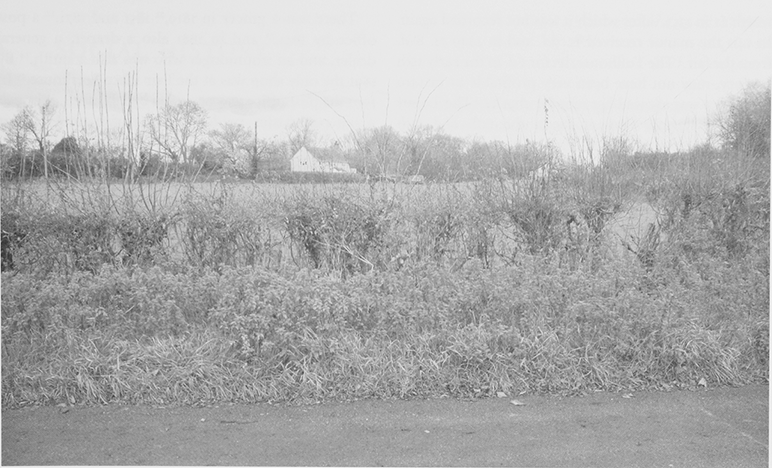
70. Fair Place is now a secondary settlement in West Lydford parish but retains at its centre a large triangle of open ground, surrounded by banks, where fairs were held until c. 1840. It was formerly larger, extending across the road which cuts through the eastern side of the ground.
TRADES AND CRAFTS
The fulling mill east of the village in 1380 and 1447 (fn. 263) appears to have gone out of use by the end of the 16th century (fn. 264) although a fuller was living in the parish in 1633. (fn. 265) Samuel Cowper a hatter (d. by 1722) (fn. 266) and John and Thomas Taunton, mercers were resident in the early 18th century. (fn. 267) Craftsmen recorded in the 17th century included a tallow chandler, (fn. 268) a maltster, a carpenter, (fn. 269) and a joiner. (fn. 270) In 1689 a Dorset man who had enlisted a soldier with both the Duke of Monmouth and William of Orange came to the parish as a cordwainer. (fn. 271)
In 1801 73 people were engaged in trades and crafts compared with 70 in agriculture and in 1811 handicrafts occupied 20 out of 93 families and 16 out of 83 in 1831 (fn. 272) but it is not clear what crafts they were engaged in. A mason and a stonecutter recorded in 1827 (fn. 273) probably worked in Keinton quarries. There were carpenters, wheelwrights, and smiths throughout the 19th century, probably due to the proximity of two major roads, with saddlers and harnessmakers, tailors, dressmakers and shoemakers. In 1901 except five dressmakers were recorded. (fn. 274) Less usual were a worsted spinner in 1841, a velvet weaver in 1861, and a milliner in 1871. (fn. 275)
RETAIL TRADES AND SERVICES
Market and Fairs
In 1260 Nicholas FitzMartin was given a weekly Tuesday market and a three-day fair around the feast of St Peter in Chains [1 Aug.]. (fn. 276) The market's tolls were worth 1 in 1353, (fn. 277) after which it was not recorded again. In 1411 the manor received 1s. 9d. and in 1449 7s. 8d. from the fair. (fn. 278) The Tollhouse, let for 6d. in the early 15th century, may not have been very profitable as in 1410 the tenant was allowed her rent for charity. (fn. 279) The Tolsey house was let for lives at 4s. in the 17th and 18th centuries. By the early 18th century the lessee also had the fair profits and was bailiff of the Ascension fair. (fn. 280) In the 1790s the Fair Place and tolls were only rated at 1d. (fn. 281) A small building on the Green in 1827, since demolished, may have been the Tolsey house. (fn. 282)
The August fair in 1692 was attended by a Bruton brazier (fn. 283) and was recorded throughout the 18th century (fn. 284) as a small peddling fair. The Ascension fair, said to have begun c. 1630, (fn. 285) had its own bailiff and was attended by pedlars from Swindon in 1701 and cattle dealers. (fn. 286) In 1748 fairs were suspended because of cattle disease. (fn. 287) In the 1780s the August fair, then held on the 12th, was noted for cattle, horses, and toys. (fn. 288) Fairs, on Lydford Fair Place, also called Lydford Green, easily accessible from the Fosse, (fn. 289) were said in 1840 to be held on 7 May, 12 Aug. and 15 Sep. (fn. 290) Old Fair place recorded in 1851 may imply that fairs were no longer held there. (fn. 291)
Shops and Services
William Moxham (d. 1707), tenant of Lydford Park farm kept a team of horses carrying between Exeter and London. (fn. 292) A tithe terrier of 1725 charged coal carriers 6d. for every horse except hackneys. (fn. 293) Coal carriers were recorded in 1841, (fn. 294) a coal merchant in 1859 (fn. 295) and a haulage contractor in 1939. (fn. 296) There was a hairdresser in 1931. (fn. 297)
There was a grocer in 1819, (fn. 297) 1851 and 1871, (fn. 298) a post office by 1841, (fn. 299) and in 1881 also a draper, a general dealer, and an ironmonger who was also a smith. (fn. 300) By 1891 the only shop was at the Fair Place beerhouse. (fn. 301) In 1901 the post office was occupied by labourers although a sub postmaster resided in the parish until 1919 or later. (fn. 302) In 1979 there were neither shops nor services. (fn. 303)
Public Houses
Two tipplers were recorded in 1608, (fn. 304) a victualler died c. 1668, (fn. 305) and two women were licensed victuallers in 1675. (fn. 306) The New inn, on the Fosse near the Fair Place was recorded in 1739 and 1742. (fn. 307) It later closed but the site was known as New Inn Corner. (fn. 308) Three victuallers were licensed in 1746, then only one until 1758 when two were licensed and in 1791 there were two public houses. (fn. 309) In 1777 the Lydford inn was possibly no longer licensed. (fn. 310) The Bell, first named in 1788, was kept by Henry Payne who drowned in the river in 1792. (fn. 311) The Crown, recorded in 1810 (fn. 312) and possibly the beerhouse recorded in 1801, (fn. 313) was the Old Crown in 1841 and no longer a public house. (fn. 314)
A brewer was recorded in 1827. (fn. 315) Two people were refused licences in 1855 because of concern over unlawful drink sales (fn. 316) and no public houses were recorded until 1871 when a cottage beerhouse was kept at Fair Place. (fn. 317) By 1899 it was the West Lydford inn, (fn. 318) the only beerhouse in 1903 (fn. 319) and 1931. (fn. 320) It was called Coombe House inn in 1939 (fn. 321) but later closed and is now a private house. The Cottage Brewery was started in a house near the church in the 1990s before moving to Lovington. (fn. 322)
SOCIAL HISTORY
West Lydford was dominated by the rector and tenant farmers. It was highly taxed in 1327, two of 16 taxpayers paid 10s. (fn. 323) In 1581 there were 21 taxpayers and in 1641 12 out of 40 taxpayers were rated at 20. (fn. 324) Many yeoman families, like that of diarist John Cannon (b. 1684), farmed in the parish for over 200 years. (fn. 325) Other families like the Tauntons amassed property during the 18th century and became gentlemen but moved away. (fn. 326) The relative wealth of some residents in the 16th and 17th century is reflected in tombs in the churchyard. They include two 17th-century chest tombs with angels and pilasters and an 18th-century tomb with angel heads are decayed state but at least one may belong to the local Pope family, benefactors of the parish. A more exotic resident was Gallop a conjurer, whose tomb was also in the churchyard. (fn. 327) The old church contained a brass to Thomas Pope (d. 1731) whose family vault under the middle aisle had folding wooden doors, fragments of a monument to Oliver Lottisham (d. 1616), his wife, and 13 children, and a monument to Thomas Taunton (d. 1767) in the porch. (fn. 328) By 1827 the highest status of residents was yeoman, 15 of whom had gardens, as did five labourers, five craftsmen, and a widow. (fn. 329)
There was severe overcrowding in the early 19th century; the poor were said to be very poor in 1818. (fn. 330) In 1801 62 families lived in 57 houses but by 1811 93 families lived in 65 houses. (fn. 331) A man had divided a house between two tenants in 1808 and this must have been a common practice. (fn. 332) In 1821 64 houses were inhabited by 89 families and in 1831 58 houses by 83 families. Migration may account for this fall in population. (fn. 333) In 1848 the vestry recommended assisted emigration for six young families totalling 29 people and a single female labourer who were willing to leave. Most were on relief but legally settled in West Lydford so the 100 cost of the scheme could be recouped in less than two years. (fn. 334) It is not clear how many left. In the later 19th century the situation improved but 20 out of 65 houses had fewer than five rooms in 1891, three had only two, increasing to 22 in 1901 (fn. 335) and up to ten pauper families were on relief. (fn. 336) One family moved to Canada in 1912. (fn. 337)
Although the only large house was the rectory, most farms, the mills, and a surgeon employed male and female domestic servants in 1841 and two tradesmen had resident apprentices. (fn. 338) In 1851 the only male domestic servant was the rector's butler although two farms still had resident labourers. (fn. 339) In 1871 the rector maintained a footman and four female servants but his successor in 1881 managed with one servant. (fn. 340) By 1901, apart from the rector who had a nurse, a maid, and a gardener, the only resident servants were one each employed by an engineer, a miller, and one farmer. However, some servants lived out and there were several charwomen. (fn. 341)
EDUCATION
Before 1666 a man had taught four boys English at West Lydford, (fn. 342) John Draper kept a school there in 1688 and there was a dame school. In 1690 Thomas Jacob, son of a former rector, set up a writing school with 20 pupils of both sexes which despite his indolence was still in existence in 1696. Humphrey Morris started a writing and Latin school in 1691 with 30 children from surrounding parishes in several classes. His sister Rebecca taught infants and needlework to the girls. The school moved to Yeovil in 1697. In 1723 John Cannon started a small school but had few pupils and his school to teach engrossing to lawyers attempted in 1728 was unsuccessful. (fn. 343)
Thomas Pope (d. 1731) left lands to provide 7 a year to teach 6 poor children for 2d. a week each for a maximum of 3 years, any surplus was to relieve the poor. (fn. 344) The legacy may have been ineffective and in 1755 Elizabeth Pope bequeathed 100 to teach poor children and relieve the poor. The money was held by the rector and churchwardens who paid 5 10s. (fn. 345) and in the 1780s 3 poor children were taught. (fn. 346) Elizabeth Pope's gift was invested in land in Baltonsborough which produced 14 14s. net in 1818 of which 5 5s. was paid to a woman to teach 20 young children. In 1825 the school taught 10 girls and 10 boys. (fn. 347) The schoolmistress was paid 5 a year from the charity. (fn. 348) In 1835 between 16 and 20 children were educated at the day school and 20 to 25 at a Sunday school both supported by the charity. (fn. 349) There were two teachers in 1841. (fn. 350) In 1846 only 4 boys and 8 girls attended the day and Sunday school with a further 6 boys and 7 girls attending on Sundays only. (fn. 351)
71. Part of a terrace of cottages behind the church of which the west end with its medieval roof, once the church house, is used as a parish hall.
The school was held in a cottage part of the former Court house behind the church. In the 1840s a schoolroom was made there with two small rooms above for the teacher. It was dilapidated in 1855 but deemed adequate in 1870. (fn. 352) In 1871 plans were drawn up for a new school. (fn. 353) The new building, known as the National school was completed in 1873 on the eastern side of the High Street, in the local vernacular style, with stone mullion windows and a porch to the main frontage. (fn. 354)
Two sisters were teacher and monitress in 1881 (fn. 355) when the teacher received 1 from the Pope charity, increased to 8 in 1902. (fn. 356) Attendance was poor. It numbered only 28 in 1883, (fn. 357) while in the 1890s many children only attended in the summer and several were withdrawn on health grounds. (fn. 358) In 1896 there were 37 children on the books but 49 went to Sunday school. (fn. 359) In 1903 one teacher taught 29 children (fn. 360) but by 1908 there were two teachers and the infant gallery was to be removed. In 1922 only 38 children attended and by 1925 only 30. In 1939 9 senior children transferred to Castle Cary. A few evacuees were admitted during the Second World War mainly from London and Hampshire but one from Glasgow. (fn. 361) In 1946 the closure of East Lydford saved the school, which obtained aided status in 1952 as Lydford on Fosse Primary school. The church room was used for extra accommodation until a prefabricated extension was built in 1958 when two teachers taught 35 children. The school celebrated its centenary in 1974. (fn. 362) In 1979 13 children were admitted and by 1986 there were 50 on the roll but only 20 in 1988 and 12 in 1990 when the school closed. Most pupils transferred to Keinton Mandeville or Baltonsborough. (fn. 363) The school became a private house.
A ladies collegiate school was kept in 1875 (fn. 364) by the Maidments, teachers of English and of music, and in 1881 a young cousin was a boarder. (fn. 365) In 1889 the school was kept by Emma and Henrietta Cornish Maidment (d. 1890) (fn. 366) and in 1891 the boarders comprised 11 girls aged 1017 and the brother of one girl. (fn. 367) It had closed before 1901. The rector had two boarders, brother and sister, in 1881. (fn. 368)
CHARITIES
Robert Walter (d. 1715) left 50 to the poor, which was invested in land in Baltonsborough. The rent, 2 15s. in the 18th century, was distributed to the poor not receiving relief. In 1757 further land was bought in Baltonsborough with Elizabeth Pope's gift producing an income of 5 10s. although maintenance work was at first deducted. (fn. 369) Income increased to nearly 19 in 1809 before falling to 14 c. 1824 and regular distributions of about 8 a year were made to the poor. (fn. 370) The two charities were administered together and from c. 1906 money was not distributed every year. Surplus income was invested and a new scheme was drawn up after the parish meeting decided to cease payments to the school. By 1908 coal was distributed and later groceries and clothing. The land was sold c. 1920. From 1925 money was also spent on special nursing and hospital care. Under a scheme of 1933 nurses or articles may be provided but although for several years the charity income has exceeded 200 very little has been distributed. (fn. 371)
HEALTH AND SOCIAL WELFARE
John Cannon records the prevalence of inherited diseases such as scrofula and dropsy in the 18th century and of stillbirths in his own family. They may have stemmed at least partly from the stability of the farming class, which meant intermarriage among a few families. (fn. 372) A surgeon was licensed in 1668, (fn. 373) an apothecary was recorded in 1766 (fn. 374) and a surgeon in 1841. Another surgeon in 1871 described himself as a general practitioner. (fn. 375) There was a resident district nurse in 1919 and 1947. (fn. 376)
In the 1700s a medicinal spring, later described as a laxative mineral water north of parish, was recommended by Dr. John Allen of Bridgwater for purging. It was still known c. 1795. (fn. 377)
In 1670 three people lived in an almshouse, possibly a poorhouse although in 1674 two of the occupants had two hearths each. (fn. 378) In 1675 on a petition from the parish a man was allowed to build a cottage on the waste, which the parish officers could dispose of after his death. (fn. 379) That may be the parish poorhouse, recorded c. 1795 as an encroachment on the waste, possibly beside the Fosse. (fn. 380) However, in 1815 the overseers occupied a house belonging to Elizabeth Hood of Butleigh Wootton, which her family owned from 1692 until 1819. There is no other reference to its being used for the poor. (fn. 381)
COMMUNITY LIFE
The Lydford and Babcary friendly society of 1810 and the Lydford friendly society of 1856 probably included members from West Lydford. (fn. 382) The old schoolroom was a church or parish room from the 1870s. It was enlarged in 1910, threatened with demolition in 1915, but extensively repaired in 1919. A pantomime was staged there in 1937, (fn. 383) and there was a Mothers Union branch by 1947 when a girls club was held in winter. (fn. 384) Social activities were shared with East Lydford. In 1979 in addition to the church room there were a recreation ground with pavilion and sports' pitches, Women's Institute, and dramatic society. (fn. 385)
John Cannon served 29 years to 1807 in the 1st Foot Guards. (fn. 386) Army and naval pensioners were recorded in 1901. (fn. 387) At least 25 local men served in the First World War, eight having joined up before December 1914 of whom two were already missing, and by 1918 a total of six had been killed, one taken prisoner, and several wounded including the rector's son. (fn. 388)
LOCAL GOVERNMENT
The vill of West Lydford was said to have been withdrawn from Catsash hundred three-week court to the hundred of Northover in 1253 and c. 1266 from the twice yearly court. It ceased to pay 2s. a year to the sheriff and had withdrawn assizes of bread and ale from Catsash. (fn. 389) Nicholas FitzMartin denied withdrawal and claimed the assizes but a jury found for the king on all points. (fn. 390) Thereafter West Lydford was represented at the hundred courts (fn. 391) and in 1600 the parish was presented there for not having archery butts. (fn. 392)
MANORIAL ADMINISTRATION
In the late 14th and 15th centuries there were three or four courts each year. (fn. 393) The court was concerned with such matters as horses trespassing in the fields, straying bees and scouring the ditches. (fn. 394) A manor court book for West Lydford survives for 15981609, a draft court roll for 1643 and copies of court roll for 164953, (fn. 395) 1684, and 1693. (fn. 396) Courts were held throughout the 18th century for tenancy business (fn. 397) but all copyholds were converted to leasehold before 1827. (fn. 398) A hayward, a reeve, and two field supervisors were elected in 1600. The hayward levied a rate for the upkeep of field fences and had a beast leaze in the common in alternate years, (fn. 399) probably to be identified with Reeve Acre, in former common meadow. (fn. 400) The church house was known as the Court house in 1604, possibly because manor courts were held there, (fn. 401) but in 1684 courts were kept in the bailiff's house. (fn. 402) The lord's pound recorded in 1674 (fn. 403) was probably the common pound used in 1809 (fn. 404) on Pound Lane, south-west of Lydford Green, now an overgrown ruin. (fn. 405)
PARISH ADMINISTRATION
West Lydford was a peculiar and the rector made visitation from 1575 when parish officers were sworn and made presentments of moral offences, non payment of tithe, failure of the rector to do duty, and repairs. During the early 18th century wills were proved and marriage licences issued (fn. 406) but later visitations were formal and held at intervals of three to six years. (fn. 407)
Two sidesmen, or assistants, were appointed in the 17th and 18th centuries. In 1706 the churchwardens were excommunicated for refusing to take the oath of office. Another was cited to appear at a visitation in 1733 and present a just account at the instance of a ratepayer. (fn. 408) By the 1750s churchwardens served as sidesmen the following year. (fn. 409) In 1847 they refused to repay the rector the cost of new church gates until he presented accounts, which he eventually did. In the 1840s a small vestry was chaired by the rector to consider church matters, to appoint a guardian, two churchwardens, two overseers, and two waywardens, and to nominate constables. (fn. 410) A turnpike keeper was constable in 1861. (fn. 411) The vestry concerned itself with emigration in 1848 and alcohol sales in 1855. (fn. 412)
In 1894 a parish meeting was established chaired by the rector. It elected overseers, assistant overseer, district councillor, and Pope's charity trustees. Formal meetings in the school were held until 1932 when members voted unanimously against union with East Lydford. (fn. 413) The civil parish was abolished in 1933 and became part of the new parish of Lydford on Fosse. (fn. 414)
RELIGIOUS HISTORY
CHURCH
The church was in existence by the mid 12th century when it was given to Wells to endow a prebend with provision for a vicar. In 1249 the bishop undertook to institute incumbents as canons but without any right to commons. (fn. 415) The chapel of St Mary was in West Lydford recorded in 1268 (fn. 416) and the church was dedicated to St Mary and All Saints in 1482, although now known as St Peter. (fn. 417) The prebend did not survive and from 1277 or earlier the church was a rectory, (fn. 418) regarded as a peculiar of the dean and chapter, which disputed the bishop's claim to make visitations in 1319 (fn. 419) and remained in possession in 1563. (fn. 420) From 1575 it was a rectorial peculiar. (fn. 421) It was united with East Lydford and Wheathill in 1965 and from 1971 was known as Lydford on Fosse. (fn. 422) In 1977 it was also held with Keinton Mandeville and from 1992 also with Barton St. David and Kingweston. It now forms part of the Wheathill Priory group. (fn. 423)
Advowson
The advowson was held with the manor (fn. 424) and in 1249 the bishop agreed that the lord should present. (fn. 425) In 1277 the dean and chapter released all claim to the advowson in return for 20 and a pension of 6s. 8d., (fn. 426) which was paid as a chief rent until 1849 or later. (fn. 427) The advowson descended with the manor, although sometimes let, (fn. 428) until 1947 when Baroness Roundway transferred it to the bishop (fn. 429) who presents at the third turn to the united benefice. (fn. 430)
Income and Property
In 1268 the chaplain of St Mary's chapel was given a house, 10 a. arable, 1 a. meadow, 1 13s. 4d. rent, and pasture for two cows. (fn. 431) In 1291 the church was worth 6 13s. 6d., (fn. 432) in 1535 7 13s. 4d. net, (fn. 433) and by the 1660s c. 70, (fn. 434) although in 1658 the advowson was valued at 100 a year. (fn. 435) The living was worth 223 a year c. 1830 but only 125 net. (fn. 436)
In 1321 the rector was allowed tithe of the mills in exchange for 2 a. of arable, (fn. 437) possibly the Presteslond let by the manor in 1380. (fn. 438) Tithes and offerings were worth 14 in 1535. (fn. 439) They were regularly farmed from the later 16th century. (fn. 440) By 1656 there were tithe compositions for the park, never known to have paid tithe in kind, and other lands based on rent. (fn. 441) In the 1780s corn tithe was paid in kind the rest by a composition, (fn. 442) said c. 1795 to have been lost. Tithes were said to be 102 13s. but a surveyor valued them at 5 for corn tithe and 42 for small tithes. (fn. 443) In 1813 the rector sued two parishioners for tithe. (fn. 444) In 1827 tithes were abolished in return for land and a capital sum of 1,549 5s. 4d. for tithe of gardens raised from tenants by mortgaging their leaseholds. (fn. 445)
In 1535 the glebe was worth 3 10s. (fn. 446) It was farmed in 1575, (fn. 447) measured c. 53 a. in 1635, (fn. 448) and was surrendered in 1827 in return for four fields (39 a.). A further 52 fields, inclosure allotments, and cottages totalling 189 a. were given to the rector in lieu of tithes. (fn. 449) The new glebe was valued at 316 18s. 4d. in 1851. (fn. 450) It included Grange farm (c. 165 a.), two smallholdings, one called Church farm, and 11 cottages, some subdivided. (fn. 451) New farm buildings were provided before 1855 but the house and cottages were dilapidated. (fn. 452) Succeeding rectors failed to repair them. (fn. 453) In 1920 the glebe was sold, apart from the rectory house, grounds and one cottage. (fn. 454)
Rectory House
In 1635 the house had detached kitchen, barn, stall, stable, and dovehouse set in 14 a. of meadow and pasture. (fn. 455) The Revd William Hungerford Colston claimed he demolished the original building in 1799 and built the present large house himself. It appears that he built only a new front range onto a possibly late 18th-century reworking of the earlier house from which a moulded beam, probably dating from the 16th century survives in the ceiling of a room west of the central passage. (fn. 456) The range of 1800 has a symmetrical front with Venetian windows in plain stone surrounds and a large stone portico on four fluted Roman Doric columns. In 1812 the same rector built a dovecot, in 1819 a walled garden, and c. 1825 a 5-stall stable, coach house and kennel block now converted to domestic use, at a combined cost nearly of 7,700. (fn. 457) Alterations were made in 1841 when the rector lived at Grange farm, including the removal of a west wing and the addition of rooms to the north. (fn. 458) In 1855 the house comprised drawing and dining rooms, library, workroom, ten bedrooms, wine cellar, china and butler's pantries, kitchen, service rooms, and outbuildings. (fn. 459) The Old Rectory has 15 a. of grounds including a stone duck house, possibly late 19th-century, by a large pond. (fn. 460) It was the clergy house of the united benefice until 1961 when a 4bedroom house was built near the rectory garden. (fn. 461) By 1977 the rector resided at Keinton Mandeville and the new rectory became a private house called Calliope. (fn. 462)
North of the Old Rectory complex, Rectory cottage dates from c. 1850 and may have replaced an existing cottage shown on the Enclosure map. Originally one of a row of five cottages in 1827, it is the only survivor. (fn. 463)
The church house The church house roof structure suggests it dates from the 15th century. Smoke blackening to the roof timbers at the west end indicates the building probably had a smoke-bay when it was used as a church house for church ales and other community events. (fn. 464) By 1604 it was used as the court house and in the early 17th century it comprised a hall, kitchen, and entry at the west end and a parlour and buttery. (fn. 465) The stable at the east end with rooms over, also recorded in the early 17th century may have been converted into or been replaced by a cottage of similar coursed rubble that certainly existed before 1827 when it was given to the rector. (fn. 466) By 1841 it was three poor cottages (fn. 467) but was used as school from 1844 until the 1873 when a new school was completed. By c. 1910 when the rector applied for permission to demolish part of the row, it consisted of three thatched cottages with outhouses at each end and a barn. A cider house and shed at the eastern end of the row were demolished and a cottage added at about this time. In 1920 the west end was conveyed to the parish as church rooms. (fn. 468)
Pastoral Care and Parish Life in the Middle Ages
William the priest was rector in the mid 12th century. (fn. 469) A chaplain recorded c. 1243 (fn. 470) may like William in 1268 have served St Mary's chapel (fn. 471) while the rectors were canons. Later rectors served the church but were often absent. William de Betville, presented 1318, was to seek deacon's orders in 1319 and was later in the bishop's employ. (fn. 472) In 1350 Walter Tinctor was given leave of absence, the church to be served twice a week by the vicar of Barton St David. (fn. 473) John Richard, rector 143148, was of noble birth and lived in London but left his corn to West Lydford church. (fn. 474) William Childe, rector 145087 and fellow of New College, Oxford, gave money to the poor and blue velvet vestments for priest, deacon, and subdeacon in honour of Mary and All Saints, white sarsenet vestments with flowers and red embroidery, and a new missal to the church. (fn. 475) His successors were also graduates including the pluralist John Watson, 14891505, and Edward Underwood, 150524, prebend of St Paul's, (fn. 476) and the parish was left to the care of assistant chaplains or curates. (fn. 477) Local piety is evidenced by the West Lydford men ordained in 1446 and 1448 (fn. 478) and the four cows given to maintain obits before 1548. (fn. 479)
Pastoral Care and Parish Life after the Reformation
William Stanley, instituted in 1550, was presumably a kinsman of the patron. (fn. 480) His successors were resident (fn. 481) but in 1575 the rector served two churches and services were not held at the due time. (fn. 482) Many people absented themselves from church for various reasons in 1606. Although there was then neither pewter pot for communion nor new Book of Common Prayer, (fn. 483) the peal of bells was maintained. The earliest surviving dates from 1587 and two others by Richard Purdue date from 1605 and 1607. (fn. 484)
Edward Wareham, although resident, also held East Lydford from 1613. (fn. 485) His successor Edward Jacob, who served from 1649, instituted by Parliament, until his death in 1689, was described as a pious scholar who lost his sight. (fn. 486) A 17th-century chest survives in the church, which formerly had a silver cup with cover dated 1706 but the cup had been altered and may have been older. A flagon by Thomas Tearle, dated 1722, was given in 1723 with money left by William Pope (d. 1715). A pewter bowl for the font was given by Thomas Pope in 1726. (fn. 487) The tenor bell was recast in 1698 by Thomas Purdue and the old treble was recast in 1742. (fn. 488) The registers were said to date from 1714 in 1883 but now survive only from 1733 for baptisms, 1739 for marriages, and 1750 for burials. A note of rectors from 1649 was presumably taken from an earlier register. (fn. 489) In 1746 rival candidates were presented but in 1747 the man presented by Edward Phelips agreed to give up the living. (fn. 490) Joseph Challoner Bale, rector 174696, lived in Hampshire. His curates included John Marsh who served for over 20 years from c. 1763. (fn. 491)
A large paten, dated 1783, may have been acquired then. (fn. 492) In 1795 the parish bought a new hautboy, which was probably used until an organ by John Gray of London was installed in 1833. A man was paid 4 guineas to teach the choir in 1810. (fn. 493)
Thomas Colston held the living from 17967 until his brother William was ordained. (fn. 494) William Hungerford Colston, rector 17971855, was a pluralist, deputy lieutenant, (fn. 495) and wealthy, with six servants in 1841 and 1851. (fn. 496) He resided and was presumably responsible for the improvement to the church in 1799 when a framed creed, lord's prayer, ten commandments, and scripture texts were painted and the vestry ordered the pulpit to be removed and a screen to be erected between the church and the tower. In 1800 over 100 was spent on repairs including 50 cwt. of roof tile, in 1805 the tower was repaired and the bells rehung, in 1806 repaving cost 40 and the tower was re-roofed in 1810. In 1821 a new pulpit, desk and sounding board were installed. Between 1822 and 1825 the church was flooded four times. (fn. 497) Colston administered communion four times a year in 1802, (fn. 498) and in 1815 and 1827 held one Sunday service, alternately morning and afternoon. (fn. 499) Following the demolition of the church for rebuilding he held services in a barn on the Green between 1844 and 1846. (fn. 500) It is likely the restoration of the village bridge and introduction of floodwater arches in 1846 was intended to ensure that the new church would not suffer again from flooding. (fn. 501) It was consecrated in 1846, and paid for by Edward Francis Colston and his brother William, the rector. William Colston and his relatives gave most of the furnishings for the rebuilt church. (fn. 502) On Census Sunday 1851 20 people attended morning service and 100 in the afternoon; 35 Sunday school children attended both services. (fn. 503) The east window by William Wailes was installed in 1852. (fn. 504)
The Revd Frederick Freeman, 185868 kept records of how often parishioners and visitors took communion and who received alms. He celebrated communion 14 times a year and privately in several houses. (fn. 505) There were two Sunday services in 1870. (fn. 506) The bells were restored in 1861 (fn. 507) and in 1871 five paid bellringers were appointed and later a paid organist and a blower. (fn. 508) In 1881 chancel, lighting, lectern, and tower screen were altered. (fn. 509) The roof needed repair in 1889. (fn. 510) Revd William Holmes Orr had four children and two boarders in 1881 but managed with one servant. (fn. 511) His successor held three Sunday services, fortnightly communion, and a children's service with Sunday school attended by 49 children in 1896. By then there was a mixed choir with 11 members. By 1909 communion was celebrated weekly but from 1914 Sunday services were reduced from three to one. (fn. 512) In 1911 the tower was restored, the treble bell was recast and a sixth bell added to commemorate King George V's coronation. (fn. 513) The church was restored between 1928 and 1933 when the roofs were rebuilt. (fn. 514) There was still a choir in 1930, (fn. 515) and new furnishings including a new reading desk and a pulpit of carved oak were given in 1934. (fn. 516)
In the 1940s and 1960s two services were held but in 1967 they were again reduced to one. A midweek communion service often had no congregation. Easter communicants numbered c. 35 in the later 20th century when the church served both Lydfords. The cup and cover were stolen in October 1969 and replaced by a chalice and paten by Leslie Thurlow of Minehead. The Methodist minister was invited to preach in 1981. (fn. 517) By 1979 the tower was in bad condition and the bells could not be rung in 2000 (fn. 518) when congregations numbered fewer than 20. (fn. 519)
Church Building
The church of St Peter lies immediately north of the river Brue in an area prone to flooding, within a roughly rectangular east-west churchyard, It replaced the medieval church, which was demolished in 1844. That church may have been the result of a major rebuilding programme c. 1333. (fn. 520) An early 14th-century effigy of a civilian, badly weathered, perhaps removed from the church to the churchyard, (fn. 521) may have been the benefactor who rebuilt the church at that time. The church, depicted by Buckler in 1833 (fn. 522) reflects further alteration after 1333. The Perpendicular windows to nave and the belfry openings appear 15th-century rather than 14th, possibly altered when the north aisle and perhaps a south porch were added. The north arcade piers may have been reused in the rebuilt church, as was the 15th-century font. (fn. 523) By 1606 the windows were decayed and the chancel roof had been damaged by people playing fives (fn. 524) and by the 1690s the tower needed repair. (fn. 525) In 1731 the north aisle roof was removed without securing the arcade, which gave way and had to be tied to the south wall with iron bars. In 1735 the church was vaulted, presumably in timber, and ceiled probably with the flat ceilings recorded in the 1780s. (fn. 526) By 1753 there was a gallery. The roof was tiled on the south but the middle and north leads were repaired in the 1750s. (fn. 527)
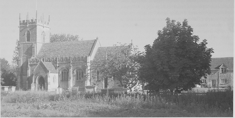
72. West Lydford church, consecrated in 1846, was built to designs by Benjamin Ferrey and replaced a 14thcentury church, which had been described as large and handsome in the 1780s. The river Brue, across the centre of this view, forms the southern boundary of the churchyard.
In the 1780s the church was large and handsome with a north aisle with four 'mitred' gothic arches and small west tower presumably medieval. The gallery of painted mahogany bore a picture of King David, the pulpit had 'grotesque' carvings, and the oak table was railed. There was possible medieval glass, including the virgin and child. (fn. 528) In the 1830s the chancel, which was much lower than the nave, had one square-headed window and a door in the south wall. The nave had a three-light Perpendicular south window with a small window alongside to light the pulpit. The south porch had an image under a crocketed canopy over the doorway whose soffit was decorated with square flowers as were the ceiling ribs in the church. The lozenge piers and pointed arches of the arcade were leaning. There was a plain octagonal font on a panelled pedestal. (fn. 529)
In July 1844 the church was demolished, apart from the tower, which was restored with additional pinnacles. A new church with chancel, nave, north aisle, south porch, and west tower was built on the same site and to almost the same plan of blue lias with Doulting dressings to designs in Somerset Perpendicular style by Benjamin Ferrey. (fn. 530)
A defaced socket with the broken stump of the cross shaft, possibly 15th-century survives in situ and may be the remains recorded in the churchyard in the mid 18th century. (fn. 531)
NONCONFORMITY
Roman Catholicism
Some people who failed to attend church in 1606 may have done so for religious reasons. (fn. 532) In 1684 a priest, George Hervey, leased a Baltonsborough field to support the missionary serving the Lydford congregation. (fn. 533) Members of the Cary and Taunton families were Roman Catholics in the later 17th and 18th centuries. (fn. 534) Mary Taunton, wife of William Goodson, was a Catholic as were many of her descendants. The family moved to Baltonsborough in the late 18th century. (fn. 535)
Protestant Dissenters
The few Quakers in the parish in the 1670s (fn. 536) possibly met in East Lydford. (fn. 537) Houses were licensed for unspecified congregations in 1703 and 1717. (fn. 538) Licences issued between 1821 and 1835 for meeting houses, including part of the miller's house at King a Mill, may have been for Methodists who were living in the parish by 1819. (fn. 539) The Wesleyan chapel, to the extreme south of the parish and west of the Fosse near the Cross Keys crossroad, was licensed and built in 1838. (fn. 540) In 1843 it had two Sunday services and one on weekday evenings (fn. 541) but in 1851 it was served with another chapel and had only evening services, attended by 55 people. The chapel, a simple two bay building of coursed and squared lias stone, accommodated 130, 50 in private seats. (fn. 542) In 1852 the rector claimed that only one family and a woman were dissenters. (fn. 543) Chapel income declined sharply after 1854, from 1869 there were 8 or fewer members, (fn. 544) and expenditure exceeded income. By 1902 the active members had left and there was no income, (fn. 545) but from 1909 there were Sunday school, weekly afternoon, and fortnightly evening services. A revival in the 1920s led to reinstatement of weekly Sunday and fortnightly Monday services and renovation of the chapel. Although there were never more than 7 members, Sunday evening service was maintained and the chapel was renovated in 1951. (fn. 546) The last service was held in 1971 (fn. 547) and the chapel was sold in 1973 and converted to domestic use. (fn. 548) Following the sale, the chapel's fenestration was much altered, although a blocked window to the rear of the building may indicate the size and shape of the original sash windows.