A History of the County of Somerset: Volume 6, Andersfield, Cannington, and North Petherton Hundreds (Bridgwater and Neighbouring Parishes). Originally published by Victoria County History, London, 1992.
This free content was digitised by double rekeying. All rights reserved.
A P Baggs, M C Siraut, 'Creech St. Michael', in A History of the County of Somerset: Volume 6, Andersfield, Cannington, and North Petherton Hundreds (Bridgwater and Neighbouring Parishes), ed. R W Dunning, C R Elrington( London, 1992), British History Online https://www.british-history.ac.uk/vch/som/vol6/pp16-21 [accessed 27 July 2024].
A P Baggs, M C Siraut, 'Creech St. Michael', in A History of the County of Somerset: Volume 6, Andersfield, Cannington, and North Petherton Hundreds (Bridgwater and Neighbouring Parishes). Edited by R W Dunning, C R Elrington( London, 1992), British History Online, accessed July 27, 2024, https://www.british-history.ac.uk/vch/som/vol6/pp16-21.
A P Baggs, M C Siraut. "Creech St. Michael". A History of the County of Somerset: Volume 6, Andersfield, Cannington, and North Petherton Hundreds (Bridgwater and Neighbouring Parishes). Ed. R W Dunning, C R Elrington(London, 1992), , British History Online. Web. 27 July 2024. https://www.british-history.ac.uk/vch/som/vol6/pp16-21.
CREECH ST. MICHAEL
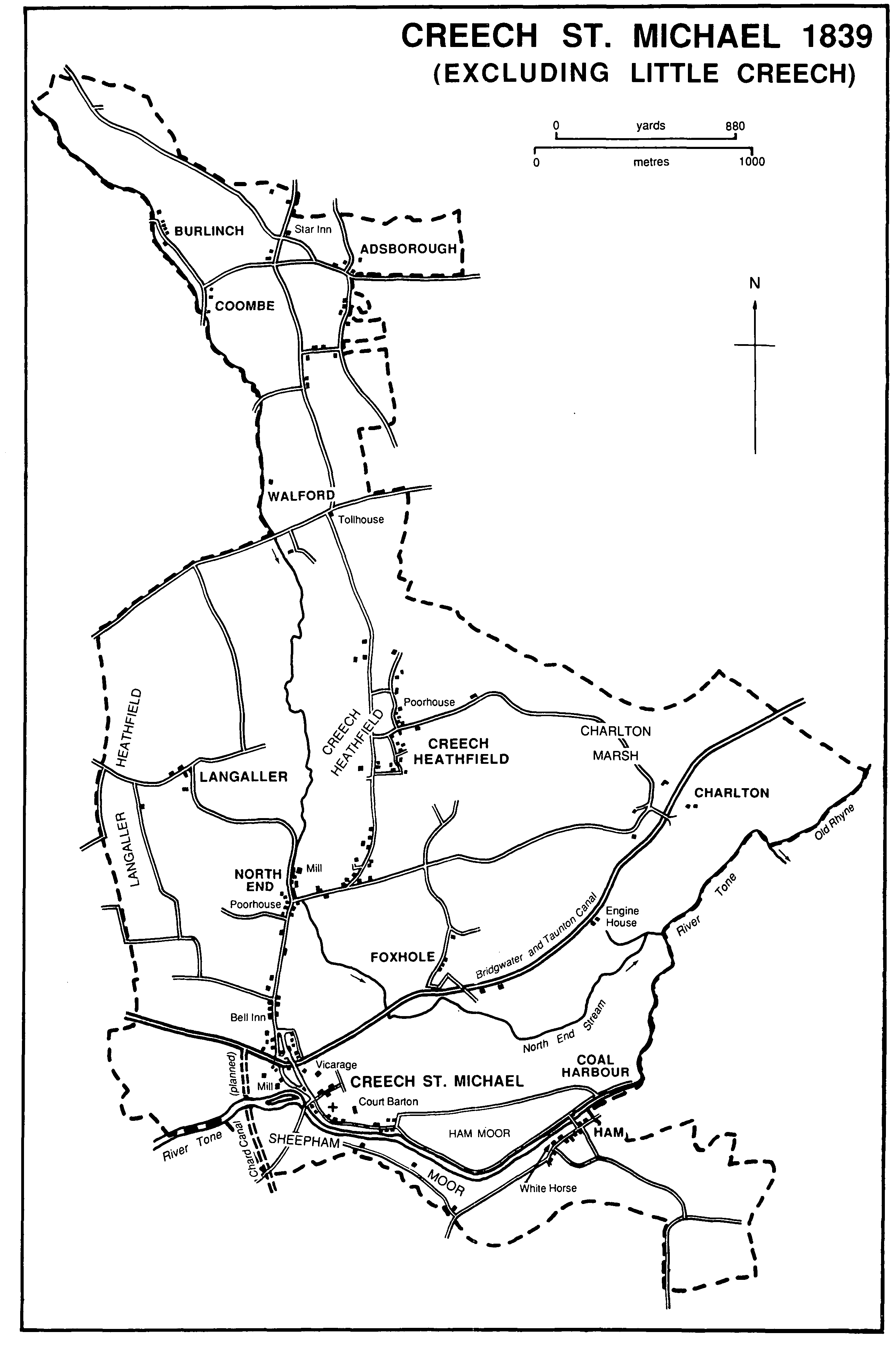
Creech St. Michael 1839
(Excluding Little Creech)
Creech St. Michael lies mostly on the north bank of the Tone 5 km. east of Taunton. The simple name Creech was normally used during the Middle Ages, but Muchel (i.e. Great) Creech was used in the early 16th century, (fn. 1) presumably in distinction from Little Creech, a detached part of the parish, and the adjective appeared in the later 16th century as Michel and in the later 17th as Michael. (fn. 2) The form Creech St. Michael was in normal use from the 19th century. (fn. 3) Irregular in shape, the parish measures 3.5 km. from east to west at its widest point and c. 3 km. from north to south, with a narrow peninsula c. 3 km. long running north into the Quantocks. Most of the parish lies on ground sloping gently from the 30-m. contour to the Tone, drained by several streams, the largest known in 1753 as the Reen and later as the North End stream. (fn. 4) The peninsula occupies the east side of a combe north of Walford as far as the 122-m. contour and includes the hamlets of Burlinch and Coombe. (fn. 5) Little Creech, an area of 25 a., lies between West Hatch and Bickenhall parishes 5.5 km. south of Creech church. (fn. 6) Little Creech was transferred to West Hatch in 1884, and the present civil parish measures 931 ha. (2,300 a.). (fn. 7)
Most of the parish lies on Upper Keuper marl and valley gravels with alluvium along the Tone and the North End stream. (fn. 8) Small pools and field names suggest digging for marl and gravel. The Upper Sandstone and Ilfracombe slates were quarried at Coombe and Burlinch. (fn. 9) 'Flint' was said to have been dug at Heathfield in the early 19th century, and clay for brick and tile was extracted near the Tone east of Creech village. (fn. 10) The Tone and a stream which may be the earlier course of that river mark much of the southern boundary of the parish and the North End stream is the western boundary of the peninsula north of Walford. The remainder of the western boundary is possibly the eastern boundary of the West Monkton estate which in the 7th century followed the course of a stream part of which may survive near Langaller. Other boundaries rarely follow natural features. (fn. 11)
Settlement in the parish was scattered: six settlements were evidently early, of which Creech village, Charlton, and Langaller were to some extent nucleated. Creech village, where the parish church stood by 1102, comprised in the later 18th century a group of houses west and south of the church along Bull Street, following the line of the river, and others north of the church along a lane which led to the fields. Further cottages lay along the road running west to Husk or Hurst Green. (fn. 12) In the 20th century new houses have been built along the village streets.
From the north-west end of the village and from Hurst Green two roads ran north to converge: the eastern one had by 1814 been replaced by a lane further east, (fn. 13) but was apparently reinstated, probably when the canal was built in 1827, and became part of the main street. The western road, formerly Pigs Barrow or Pigs Barrel Road, was renamed Curvalion Road in 1962. (fn. 14) The easternmost road was severed by the canal and the railway. Until the 1960s a few farmhouses and detached houses lay along the road north to North End: (fn. 15) a 17th-century farmhouse, altered in the 19th and 20th centuries, survived as a dwelling and a shop in 1984. In the later 20th century many new houses were built on the west side of the village between the canal and North End.
Creech Heathfield, probably a squatter settlement on the edge of the Heathfield, includes a 17th-century house, now the Crown inn, and had a poorhouse from 1652. (fn. 16) During the 20th century many houses were built east of the road.
East of Creech village, Ham, recorded in 1303, lies along the eastern end of White Street (fn. 17) on the south bank of the Tone; it is partly in North Curry parish. Charlton, north-east of Creech village, and Langaller, north-west, were both mentioned in 1327, (fn. 18) but the name Charlton suggests a pre-Conquest community of either free peasants or villeins.
There are four settlements on the higher ground in the north. Walford was recorded as Wealaford in 682, (fn. 19) and Adsborough as Tetesberge in the 11th century. (fn. 20) Coombe and Burlinch are small settlements in the valley north of Walford. Foxhole, a small scattered hamlet between Creech village and Charlton, now divided by the Bridgwater and Taunton canal, may have been a squatter settlement on the edge of ancient woodland.
Langaller contains several early houses. Langaller Farm, now called Langaller Manor, is a late-medieval house altered in the 17th century and again in the 20th. It probably originated as an open-hall house, later ceiled to provide a three-roomed, cross-passage house. (fn. 21) Langaller Manor Farm and Langaller House date from the 17th century. Langaller House is an L-shaped house, much altered in the late 18th or early 19th century. In 1868 it was said to have been recently improved. (fn. 22) Adsborough contains several houses dating from the 17th century or earlier including at least one medieval house. (fn. 23)
A common field called Ferringdons, north of Creech Heathfield, was recorded in 1604 (fn. 24) and strips survived in Creech field, west of Creech village, in 1839. (fn. 25) Field boundaries suggest open arable cultivation between Creech field and Langaller and between Langaller and Walford. (fn. 26) Common meadows, pastures, and moors lay beside the Tone in the south. Creech and Langaller Heathfields, common pastures at Ham, Sheepham, shared with Ruishton, and Charlton Marsh, and several greens, probably former manorial waste, were inclosed in 1814. (fn. 27) New Mead and Mermead remained in multiple ownership in 1839. (fn. 28)
Woodland may have governed the settlement pattern of the parish. There was woodland in 1086 measuring a furlong square. (fn. 29) Creech wood, which may formerly have occupied a large area on the east side of the present village street between the church and North End, still measured 50 a. in 1559. Oak, ash, and other timber was sold in 1619, the purchaser having to make good the ground after the removal of roots. (fn. 30) Ancient boundary banks, a hedge surviving from ancient woodland, and lichen species indicate the considerable former extent of the timber cover. (fn. 31) The names Creech Heathfield and Langaller Heathfield may suggest earlier, and less effective, woodland clearance. There were nearly 7 a. of woodland in 1839, (fn. 32) 4 a. in 1905, (fn. 33) 12 a. in the 1940s, (fn. 34) and only 1 ha. (c. 2.5 a.) in 1982. (fn. 35) A field east of Court Barton was called Coneygar. (fn. 36)
Two routes crossed at Creech village. An east-west route from the North Curry ridge crossed the Tone at Ham and led to Creech village through Ham moor. An alternative led through Ham and along the southern side of the Tone to Creech bridge. From the bridge the route led west along Husk Green Drove towards Hyde Lane in Bathpool and Taunton. A north- south route runs from the Quantocks through Creech Heathfield and North End to cross the east-west route before going over the Tone into Ruishton. The importance of the riverside route presumably depended on river traffic at Ham. (fn. 37) At North End the road divided to serve Langaller to the north-west and Charlton and Creech Heathfield to the east and north-east respectively, the latter continuing north to Adsborough. The roads from Taunton to Bridgwater and Glastonbury, which pass through the northern tip of the parish, were turnpiked by the Taunton trust in 1751-2 (fn. 38) and posts and a tollgate erected at Walford where the two roads divided. (fn. 39) The Taunton turnpike trust ceased in 1875. The tollhouse, rebuilt c. 1850, was moved to Durston c. 1874. (fn. 40) The old pattern of lanes in the parish has been disrupted by the canals, railway, and motorway. Creech or Tone Bridge was repaired by the hundred of Andersfield in the 1620s. (fn. 41) It was improved in 1830 and enlarged in 1848. (fn. 42) There was a bridge at Ham before 1709 and two more were ordered to be removed that year. (fn. 43) A new bridge at Ham was built in 1758 but by 1839 it had been replaced by a bridge further east on the site of the present footbridge. (fn. 44) A private suspension bridge linking Coal Harbour with Ham was built in 1968 (fn. 45) to replace an earlier bridge. (fn. 46)
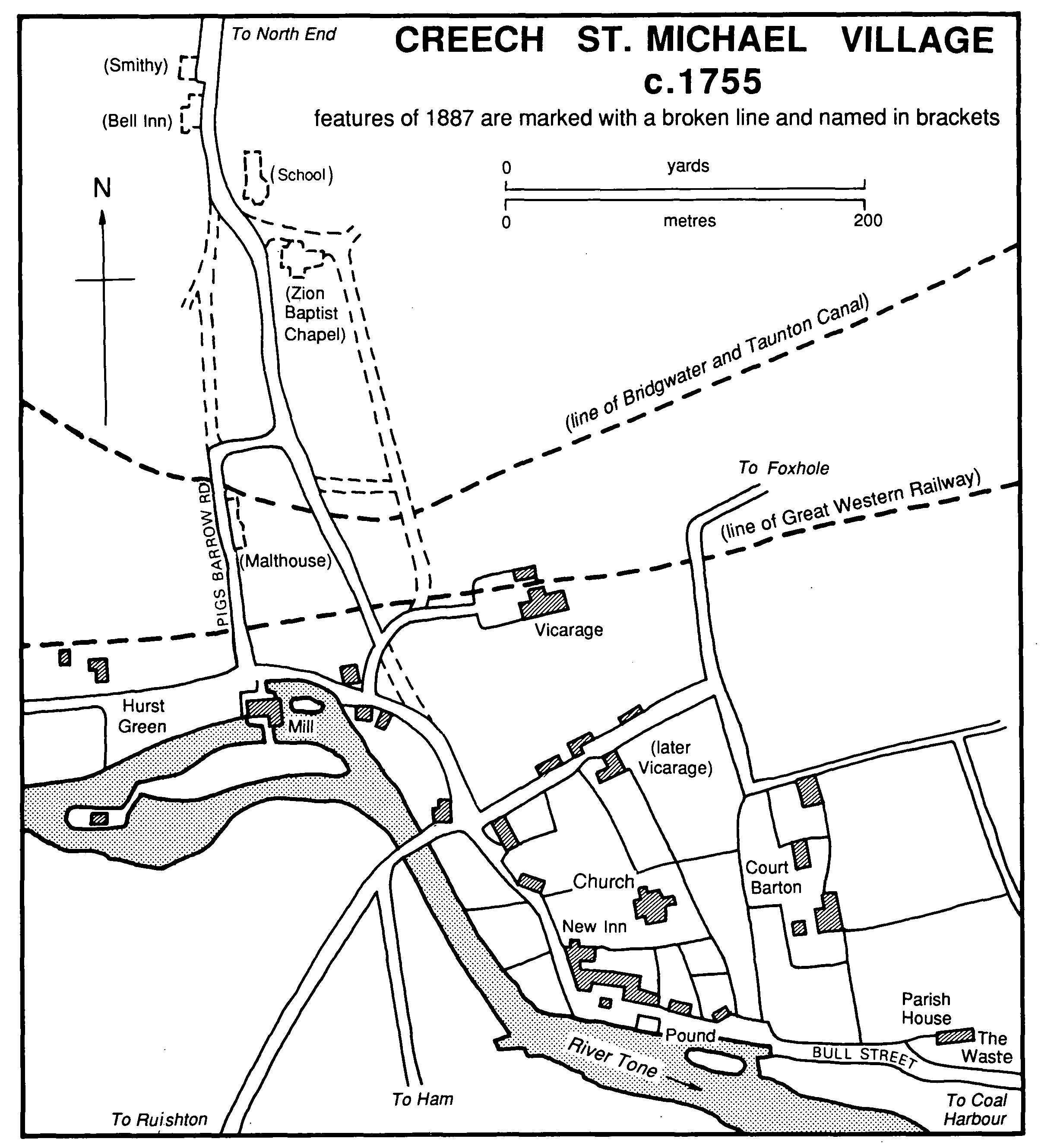
Creech St. Michael village c.1755
features of 1887 are marked with a broken line and named in brackets
The parish enjoyed relative prosperity in the 17th and 18th centuries, based apparently on a mixed economy involving river traffic. Land called Colehouse, on the north bank of the Tone opposite Ham, was evidently by 1559 a landing place for coal and probably other heavy goods from Bridgwater. (fn. 47) Coal Harbour House appears to date from the early 17th century, and its ornamental plasterwork includes the arms of the Merchant Adventurers Company and a fireplace with the initials 'R.M.B.' and the date 1679. (fn. 48) In 1684 Richard Bobbett took a lease of the 'back river' and a moor, with the right to land coal. (fn. 49) By 1714 there were warehouses, a salt house, pans, and cellars, a smithy, and landing areas. (fn. 50) A warehouse was built c. 1783 (fn. 51) but business declined in the 19th century and by 1839 there were only three coal yards along the river. (fn. 52) Coal Harbour House alone remained in 1984.
The river Tone was improved for navigation by the Tone conservators under proposals drawn up in 1698 with Ham as the point of toll between Bridgwater and Taunton. Tolls for traffic from Bridgwater were paid at Ham Mills in North Curry and for traffic going up to Taunton at Coal Harbour. (fn. 53) At Coal Harbour the river was widened leaving an island between the old and new branches linked by bridges. (fn. 54) The western branch had been filled in by the late 19th century. (fn. 55) Locks were constructed to improve navigation near Ham and at Creech mills. (fn. 56) After serious flooding in 1960 the river was deepened and widened, and New Cut was made south of Creech Bridge to carry excess water. (fn. 57) The Bridgwater and Taunton canal running east-west through the parish was cut in 1827, with a pumping station between Foxhole and Charlton to lift water from the river. (fn. 58) The engine house survives. The Chard canal opened in 1842 (fn. 59) and closed in 1866. (fn. 60) To its junction with the Bridgwater and Taunton canal it was carried by buttressed walls which survive, together with nearby buildings converted for defence during the Second World War.
Alongside the Bridgwater and Taunton canal runs the railway, opened in 1842. (fn. 61) A halt in Creech village was opened in 1928 and closed c. 1969. (fn. 62) The branch line to Chard alongside the Chard canal was opened in 1866 and closed in 1963. (fn. 63)
In 1619-20 there were two inns in the parish, the Fiery Dragon and the Prince's Arms. (fn. 64) The first, probably that in Creech village later known as the Green Dragon or Creech Inn, and formerly the church house, (fn. 65) still belonged to the lord of the manor in 1794. (fn. 66) It was rebuilt before 1768 and thereafter was also called the New Inn. (fn. 67) The names Creech Inn and New Inn were both used until the early 20th century. (fn. 68) It was renamed the Riverside Tavern in 1986. During the late 17th century there were up to five inns or alehouses in the parish and up to three in the early 18th century. (fn. 69) There were four in 1750, including two disreputable alehouses at Ham, (fn. 70) one called the White Horse established by 1726. (fn. 71) The Ship, next to the New Inn, was opened by 1768, (fn. 72) but had become a malthouse by 1774. (fn. 73) The Ball or Blue Ball was recorded between 1779 and 1786. (fn. 74) The Bell inn, in Creech village, was first licensed in 1823 and remains in business. (fn. 75) There was an alehouse on a coal wharf beside the Bridgwater and Taunton canal in 1831 (fn. 76) and another, called the White Lion, at its junction with the Chard canal. (fn. 77) By 1851 there were six public houses in the parish, (fn. 78) and in the 1860s and 1870 as many as eight. (fn. 79) They included the Lane End beerhouse at Ham, open until c. 1963 another beerhouse there, (fn. 80) and one at Coombe. (fn. 81) The Star at Adsborough, open by 1839, was renamed the Maypole in 1981 (fn. 82) and the Crown at Creech Heathfield was open by 1871; (fn. 83) both were in business in 1984. There was a beerhouse at Walford by 1910 which was still open in 1914. (fn. 84)
A friendly society for Creech, West Monkton, Thornfalcon, and Ruishton was founded in 1787. It met at the New Inn in 1820 and held a Whit Monday feast. (fn. 85) It was refounded in 1827 as the Creech Union Club, claiming in the 1830s to have members from a large number of surrounding parishes. (fn. 86) The Creech Young Club was founded in 1822 and was still active in 1837, and the Commendable Society was in existence in 1836. (fn. 87) During the 19th century a village revel was held in September. (fn. 88) Adsborough men's institute and reading room was set up in 1904 and was wound up in 1916. (fn. 89) The Creech Institute was recorded in 1914. (fn. 90)
There were 63 taxpayers in the parish in 1327, (fn. 91) 161 in 1377, (fn. 92) and 89 in 1526. (fn. 93) In 1664-5 110 householders were liable for hearth tax and 41 were exempted. (fn. 94) In 1760 154 male residents were recorded. (fn. 95) There were 133 houses in the parish in 1781 (fn. 96) and 166 in 1821. The population rose from 608 in 1801 to 812 in 1821 and to 1,116 in 1831. Railway labourers accounted for the increase to 1,296 in 1841, and thereafter the total declined to 1,073 by 1871. The opening of the paper mills led to an increase to 1,166 in 1881, and subsequent decline was slower than in many neighbouring parishes. New building in the later 20th century caused the population to rise again, reaching 2,279 in 1981. (fn. 97)