A History of the County of Wiltshire: Volume 12, Ramsbury and Selkley Hundreds; the Borough of Marlborough. Originally published by Victoria County History, London, 1983.
This free content was digitised by double rekeying. All rights reserved.
A P Baggs, Jane Freeman, Janet H Stevenson, 'Parishes: Aldbourne', in A History of the County of Wiltshire: Volume 12, Ramsbury and Selkley Hundreds; the Borough of Marlborough, ed. D A Crowley (London, 1983), British History Online https://www.british-history.ac.uk/vch/wilts/vol12/pp67-86 [accessed 30 April 2025].
A P Baggs, Jane Freeman, Janet H Stevenson, 'Parishes: Aldbourne', in A History of the County of Wiltshire: Volume 12, Ramsbury and Selkley Hundreds; the Borough of Marlborough. Edited by D A Crowley (London, 1983), British History Online, accessed April 30, 2025, https://www.british-history.ac.uk/vch/wilts/vol12/pp67-86.
A P Baggs, Jane Freeman, Janet H Stevenson. "Parishes: Aldbourne". A History of the County of Wiltshire: Volume 12, Ramsbury and Selkley Hundreds; the Borough of Marlborough. Ed. D A Crowley (London, 1983), British History Online. Web. 30 April 2025. https://www.british-history.ac.uk/vch/wilts/vol12/pp67-86.
In this section
ALDBOURNE
Aldbourne, a downland parish north-east of Marlborough and south-east of Swindon, includes Aldbourne village, the hamlets of Upper Upham and Woodsend and part of that of Preston, and the deserted hamlet of Snap. (fn. 1) It measures 3,441 ha. (8, 502 a.) (fn. 2) and forms a rough square with an extension at its north-west corner. The parish's northern boundary, later also the hundred boundary, had for its western two thirds apparently been established by the mid 11th century along Rogues or Sugar Way, which is said to have run approximately east and west c. 4 km. north-west of Aldbourne village. (fn. 3) The parish was largely conterminous with a single estate, Aldbourne manor, on which there was a church in the late 11th century. (fn. 4) In the 16th century the manor's boundary closely resembled that of the modern parish, excluding the northwestern extension. (fn. 5) That extension was included in the parish at an unknown but probably early date. Aldbourne's western boundary is marked by the Roman road from Cirencester to Cunetio, now in Mildenhall; another Roman road, Ermin Street, crosses Sugar Way and forms the east end of the northern boundary of the parish. Some 250 m. west of Baydon village the boundary turns south across downland and follows a dry valley to the Swindon-Hungerford road. Until 1934 it crossed the road and ran south along a small stream to Preston, where it turned southwestwards. The boundary was then moved east to the road north and south of Ford Farm and 6 a. were thus transferred from Baydon to Aldbourne. (fn. 6) The southern boundary is marked by few natural or man-made features until it reaches Whiteshard Bottom, where it turns north-west along a dry valley for 2 km. It continues north and northwest for another 2 km. and then turns due west to the Roman road from Cirencester.
Much of the parish lies above 152 m. and the chalk which outcrops over it is covered on the higher downland by clay-with-flints, which extends in a broad band across the southern part of the parish and in an east-facing arc between Woodsend and Upper Upham. (fn. 7) The highest land in the parish, above 259 m., is west of Woodsend. Westwards from there it descends steeply, flattening out towards the western boundary. Valleys, some of them steep-sided, converge on the south-east corner of the parish. The boundary stream, flowing south-east to the Kennet, rises c. 200 m. east of Aldbourne church. The other valleys are dry but gravel has been deposited in all of them. Prehistoric cultivation took place near Upper Upham and Snap, near North Farm in the north-east corner of the parish, and near the farmstead called Stock Lane. (fn. 8) Some of the clay in the central and southern parts of the parish continued to be ploughed in historic times and there was also arable land in the valleys around Aldbourne village and probably on the level chalk west of Lower Upham Farm. Land near the southern and south-western boundaries, much of it wooded, formed Aldbourne Chase. The chalk downs were mostly pasture and those in the middle of the parish, probably between Dudmore Lodge and Sugar Hill, were used as a warren in the Middle Ages and until the 18th century. (fn. 9)
Part of a ditch extending from Liddington Hill in Liddington to Church Hill in Ogbourne St. George marks the western extent of archaeological discoveries within the parish, and there is little evidence of prehistoric activity south of Aldbourne village. Elsewhere, artefacts of the Neolithic Period and later have been found, and there are numerous barrows, especially on the downs north and west of the village, and earthworks south of Woodsend. (fn. 10) There was a substantial settlement at Upper Upham; IronAge and Romano-British finds have been made there and an associated field system covers 113 ha. (fn. 11) Smaller field systems lie east of Snap, north of Stock Lane Farm, and on Peaks Downs. Other Romano-British finds have been made at North Farm, North Field Barn, and the farmstead called Hillwood, north of Stock Lane. Lewisham Castle, east of Stock Lane Farm, is a circular medieval earthwork. (fn. 12)
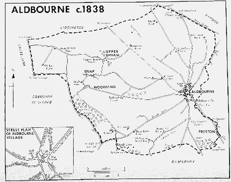
Aldbourne c.1838
Whereas the parish is apparently bounded on its west, north, and north-east sides by ancient roads, the only early routes to cross it are the track from Liddington to Mildenhall along the ridge east of Lower Upham Farm and another ridge way, which may have existed in the 11th century or earlier, along the crest of Sugar Hill. (fn. 13) The principal route through the parish is the Swindon-Hungerford road, turnpiked in 1814, (fn. 14) which runs in a dry valley north-west of Aldbourne village and beside the stream south-east of it. Another road runs parallel to that one, joining roads from Mildenhall to Ramsbury and from Aldbourne to Ogbourne St. George. In the late 18th century as in 1982 most other roads led from the village. (fn. 15) North from Aldbourne roads led over the downs to Baydon and along a dry valley via North Farm to Wanborough: that to Wanborough was called Port Street in the 15th century and the 16th. (fn. 16) Another road, perhaps in the 17th century and certainly in the 19th called Grasshills Lane, led north to Bishopstone (fn. 17) and had become a track by the 20th. A road to Ogbourne St. George ran west from Aldbourne and turned south-west at Woodsend. Another, called Stock Lane, led south-west to Marlborough in the 18th century and the early 19th (fn. 18) but, west of Stock Lane Farm, that road was later neglected in favour of the road via Axford and Mildenhall and by 1982 it had there become a track. South of Aldbourne village tracks fanned out to Ramsbury via Love's Copse, to Hilldrop in Ramsbury, and to Stock Close Farm. Others from Picked Cross to Upham and Snap had become footpaths by the 20th century. (fn. 19) In 1982 Upper Upham was reached by a drive from Warren Farm. A track from Upper Upham to Lower Upham was still in use in the mid 20th century, but was little used thereafter. (fn. 20) The farmstead called East Leaze was approached by a track from the Aldbourne–Wanborough road in the late 18th century as later. (fn. 21)
Medieval tax assessments show Aldbourne to have been the wealthiest parish in the hundred and in 1377, when there were 332 poll-tax payers, the most populous. (fn. 22) Tax assessments were still high in the 16th century when totals were inflated by assessments of wealthy individuals. (fn. 23) Between the mid 16th century and the mid 17th the population may have doubled; there were c. 400 adults in 1549 (fn. 24) and c. 800 in 1637 and 1676. (fn. 25) In 1801 the population was 1,280. Numbers had increased to 1,622 by 1851 but fell thereafter to 1,117 in 1901 and 980 in 1921. The population had grown to 1,024 by 1931 (fn. 26) and increased considerably after the Second World War. In 1971 there were 1,459 inhabitants. (fn. 27)
The main centre of population, Aldbourne village, lies near the eastern boundary at the junction of five dry valleys, where the tributary stream of the Kennet rises, flowing south-east in a sixth valley. Preston lies further downstream in that valley and the site of the deserted hamlet of Snap, 4 km. west of Aldbourne, is also near the bottom of a steep-sided valley. On the hills above Snap are the hamlets of Upper Upham, 700 m. north of it, and Woodsend, 400 m. south. Also on the downs are scattered farmsteads, some occupying sites in use since the Middle Ages but most dating from the 17th century or the 18th. (fn. 28)
In the Middle Ages much of the wealth of the parish was concentrated in Aldbourne village, where there was a market, then apparently thriving. Tax assessments for the village were high and in 1377 there were 253 poll-tax payers. (fn. 29) Aldbourne prospered as an industrial centre in the 18th century but in 1826 was said to be decaying. (fn. 30) A fire in 1760 which destroyed 72 houses and some other buildings, another in 1770 in which 80 houses and 20 barns were burned down, and a third in 1817 in which 15 cottages, 3 barns, and 2 malthouses were lost, (fn. 31) all contributed to its decline. There was rebuilding or new building after the fires, however, and it seems unlikely that the extent of the village changed much. (fn. 32) Its population was 1,233 in 1851. (fn. 33) There was a new expansion in the 20th century when the village became a dormitory for workers from Swindon and elsewhere.
Earliest settlement in the village may have been on gravel near the stream which surfaces beside Lottage Road, the road to Wanborough, and flows south-east beside the SwindonHungerford road, there called South Street. The church was built on chalk on higher ground north-west of the stream, and north of the church is Court House which was occupied in the 16th century by tenants of the demesne farm of Aldbourne manor, and in the 19th century was the vicarage house. (fn. 34) The central part of the house is of the late 16th century: it has thick walls with stone-mullioned windows, and ceiling beams in the principal rooms have been covered in heavily moulded cases. A small addition was made on the east side of the house in the 18th century and rooms were added along the west side during the 19th. The rectangular green south of the church may have been the market place in the Middle Ages as it probably was in the late 18th century. The market cross, restored after the fire of 1760 and again later, has stood on the Green since the early 19th century or earlier. (fn. 35) It is possible, however, that the Green may occupy the site of houses destroyed in one of the fires. Most of the buildings around it date from the late 18th century or the early 19th and were perhaps rebuilt after the fires. In the 18th century and the early 19th the Green was called High Town (fn. 36) but in the 20th century Hightown was the name of a house at its south-east corner, to which racing stables were attached. (fn. 37) The streets bordering the Green are the north-eastern section of a grid formed by streets running almost north and south and almost east and west; the grid extends south to the Swindon-Hungerford road. That road may have run continuously south-east through the village and have been diverted by new, planned building on the grid pattern. Its modern route, turning sharply south and east as part of the western edge of the grid and its southern boundary, had probably been established by the 17th century, the date of the oldest buildings within the grid, and may be much older. North of the road Back Lane marks the western edge of the grid and leads north to the school. At the south-western corner of the grid the major routes into the village meet. North-east of the junction the road from Baydon opens out as the Square, an irregularly shaped space at the modern centre of the village. Within it is the pond, which dates from the 18th century or earlier (fn. 38) and for which a concrete base was provided in the late 20th. Although a house on the north side of the Square is probably 17thcentury, most of the buildings within the grid date from the late 18th century or the early 19th and were probably rebuilt like those around the Green.
Building spread along the roads radiating from the village centre. The earliest extension may have been along Lottage Road; the name Lottage was in use in the mid 13th century. (fn. 39) Beside the stream at the southern end of the road are cottages of the 17th century or earlier. Further north are 19th-century houses, including Alma Cottage, once isolated at the northern end of the village. (fn. 40) Beside Grasshills Lane west of Lottage Road is Beech Knoll, a large early 19th-century brick house. Oxford Street, which leads northeast from the Square, was called Baydon Street from the 17th century or earlier until the late 19th. (fn. 41) In the late 18th century and the early 19th, as in 1982, there were houses along its eastern side to a point 250 m. north-east of the Square, where a steep bank, perhaps the edge of a former chalk pit, rises above the street. (fn. 42) Many of the buildings there are small cottages of the 18th and 19th centuries. In 1809 there were a few houses west of the street south of its junction with Lottage Road; by 1837 more had been built north of the junction. (fn. 43) Other new building west of the road in the 19th century included a chapel south of the junction. (fn. 44) Until 1900 a windmill 300 m. north of the junction marked the edge of the village. (fn. 45)
Until the 19th century many of the farmsteads of Aldbourne stood beside the north-western or south-eastern arms of the Swindon-Hungerford road, West Street and South Street. In the late 18th century and perhaps earlier the principal farmstead of Aldbourne manor stood south-west of South Street, straddling Southward Lane. (fn. 46) In 1809 and 1837 it was the largest farmstead in the village; (fn. 47) an early 19th-century farmhouse survives. Other former farmhouses include the Old Malthouse and Glebe Farm, both 18thcentury buildings, which stand respectively north-east and south-west of South Street, and the Old Rectory, a red-brick house of the early 19th century, south of the Square. Industrial buildings in South Street included the malthouse, a fustian factory north-east of the street in the 18th century and the 19th, and a chair factory south-west of it in the 19th. (fn. 48) In the early 19th century a workhouse stood at the north-western end of the street (fn. 49) and Yew Tree House, a villa in Gothic style, was built near the fustian factory. There were farmsteads beside West Street in the 16th century (fn. 50) and probably earlier. Rose Cottage, north of that street, and a thatched farmhouse and barn further west are of the 17th century or earlier. East of St. Michael's Close, which leads north from the street, there are 18th-century houses. In the early 19th century cottages, including a row of four leading south from the street, and Manor Farm, a red-brick house with a Gothic front at the western end of the village, were built. Between the junctions with Back Lane and with Castle Street and Marlborough Road, the lower part of Stock Lane, 18th- and 19th-century cottages, mostly small and of brick, line the western side of the street.
There were houses in Castle Street in the 16th century (fn. 51) but most surviving cottages are 19thcentury, thatched, and built of stone rubble. A row of flint cottages stands on higher ground some 400 m. west of the junction with Marlborough Road. Along Marlborough Road the buildings are larger and more scattered. East of the road stands a thatched timber-framed house, west of it are 19th-century houses. The road turns sharply west 200 m. from the junction with Castle Street. South of the bend the Butts is a row of small thatched cottages, apparently built on waste ground in the late 18th century and the early 19th. Other cottages of similar date are further south.
In the early 20th century there was some infilling in the centre of the village, including the Memorial Hall in Oxford Street: private houses were built further north beside that road and beside Lottage Road, and council houses beside Southward Lane. The greatest expansion of the village, especially northwards, took place in the 1960s and 1970s. Bungalows were built east of Lottage Road and there was a large development of private houses west of it in Cook Road, Cook Close, and Grasshills Lane. A small factory was built near the southern end of Lottage Road. Private houses were built on the site of Hightown stables, bungalows in St. Michael's Close, and council houses north of Castle Street and south and east of the Butts.
There is said to have been an inn at Aldbourne in 1516 and one in or near Grasshills Lane in 1617. (fn. 52) The Crown, in the Square, was recorded in 1735. (fn. 53) A house south of the Green was the George inn in the early 18th century; the inn was closed in the early 19th. (fn. 54) The Bell, open in 1809, stood north of the junction of Castle Street and Marlborough Road. (fn. 55) It was closed in 1958. (fn. 56) The Blue Boar east of the Green was open in 1822, (fn. 57) closed in 1911, but reopened in or before 1931. (fn. 58) The Queen inn, east of the SwindonHungerford road between Back Lane and Castle Street, opened between 1837 and 1848. (fn. 59) Known as the Queen Victoria from 1855, (fn. 60) it was closed c. 1970. (fn. 61) Across West Street from it was the Mason's Arms, opened in or before 1920. (fn. 62) West Street House, adjoining the inn, was apparently once part of it. (fn. 63) The Crown, the Blue Boar, and the Mason's Arms were open in 1982.
Of the outlying farmsteads that with the longest history of occupation may be Laines, perhaps on the site of the medieval farmstead called Pickwood. (fn. 64) A farmhouse stood there in 1773. (fn. 65) That or a later house was replaced in 1938 (fn. 66) by a stone house with, at each end of a central north-facing block, circular extensions from which led a long north-east wing and a shorter north-west wing. New farm buildings were then built 1 km. north-west of the house. A house called Dudmore Lodge was built in the early 16th century. (fn. 67) The early 19th-century farmhouse so called may be on its site. There was a farm and probably also a farmstead called Stock Close c. 1700. (fn. 68) Stock Close Farm was standing in 1773; (fn. 69) the surviving buildings may be of that date or a little later. The farm buildings were replaced after a fire in 1874. (fn. 70) Cottages stood east of the farmstead in the late 19th century but were demolished in the mid 20th. (fn. 71) In the late 18th century other farmsteads included that called Stock Lane, a little east of the junction of the lane and the road from Ramsbury, Aldbourne Wood, c. 800 m. south-east, Ewins Hill, 1.5 km. east, and Hillwood, c. 300 m. north of the junction. (fn. 72) Only that at Ewins Hill survived in 1982. Most of the buildings of Stock Lane Farm were disused in the early 20th century; (fn. 73) a 19th-century cottage remains. Farm buildings were erected beside the lane c. 1 km. north-east of the old farmstead in the late 20th century. Hillwood was also deserted between 1900 and 1910 (fn. 74) but a bungalow and stables were built there after the Second World War. North of Aldbourne village East Leaze, a 19th-century farmhouse, stands on the site of a farmstead of the late 18th century or earlier. White Pond is a 20th-century house beside earlier farm buildings. Warren Farm is also on a site of the 18th century or earlier (fn. 75) although the large farmhouse is of the early 19th century. East of it are cottages of a slightly later date. North Farm and cottages south of it were built between 1809 and 1837. (fn. 76) At North Field Barn are farm buildings and cottages of the late 19th century east of the Aldbourne-Wanborough road and an early 20th-century house west of it.
In the 14th century Snap was the smallest settlement in the parish, and one of the poorest in the county; there were 19 poll-tax payers in 1377. (fn. 77) In the early 17th century there was a row of five cottages along the southern side of the valley. (fn. 78) There may have been a cottage nearby at Woodsend in the early 16th century. (fn. 79) In 1773 there were between 5 and 10 houses at Snap, about half as many at Woodsend, and Leigh Farm between them. (fn. 80) Woodsend expanded in the early 19th century; c. 1850 it included sixteen cottages, and a chapel and a school were built. The population in 1851, including that of Leigh Farm, was 84; at Snap there were 41 inhabitants. (fn. 81) Agricultural changes led to the desertion of Snap soon after 1900. (fn. 82) In 1909 there were only two residents. Most of the houses were destroyed by Army gunnery practice during the First World War, although an uninhabited farmhouse still stood in the 1930s. (fn. 83) Rubble marked the sites of houses in 1982. At Woodsend the school and chapel were closed and several cottages abandoned in the early 20th century. Later there was some new building for which materials from Snap were used. (fn. 84) In 1982 there were cottages scattered on the north side of the road from Aldbourne to Ogbourne St. George and beside the track to Leigh Farm, then called Snap Farm.
Early settlement at Upper Upham may have continued into historic times. (fn. 85) In the 14th century Upham was a small village, having 40 poll-tax payers in 1377, and was poorer than the average community in the hundred. (fn. 86) There may have been some six houses at Upper Upham in the 16th century. (fn. 87) In the first decade of the 17th century there were two large and recently built houses; Upper Upham House north of the lane leading to Lower Upham and another south of it. Between Upper Upham House and the lane were two cottages. (fn. 88) Only Upper Upham House, its farmstead, and a cottage, later High Clear House, south-east of them, were standing in the late 18th century and the early 19th. (fn. 89) In 1851 the population of the hamlet was 34, of whom 18 lived in Upper Upham House and its outbuildings. (fn. 90) West of the house Eyre's Barn, later a house, had been built by 1900 (fn. 91) and extensive outbuildings were added in the early 20th century. They were altered and extended, and new farm buildings and Summerdale Cottages, a crescent of large houses, were built in the 1960s. (fn. 92) Lower Upham was never more than a farmstead. The stonewalled farmhouse is of the late 16th century or the early 17th, extended southwards in the early 19th century. In 1982 there were two groups of cottages of the 19th century and the 20th west of the house. There was a farmstead called Blake's 800 m. south-west of Lower Upham in 1773; (fn. 93) some buildings survived in 1960 (fn. 94) but they had been demolished by 1982.
Preston stands at the junction of the road from Marridge Hill in Ramsbury with the SwindonHungerford road. Only the buildings west of the stream are in Aldbourne parish. Of those only Preston Old House, the most southerly, was standing in 1773. (fn. 95) A round, thatched tollhouse was built east of the Swindon-Hungerford road in the early 19th century. (fn. 96) Little Orchard and Alma Farm west of the road are also 19th-century buildings.
In 1643 a parliamentary army marching from Gloucester to London was attacked by Prince Rupert's cavalry north of Dudmore Lodge, driven thence into Aldbourne village, and forced to withdraw to Hungerford. (fn. 97) In April 1644 a muster of some 10,000 royalist troops was held in Aldbourne Chase, and there is said to have been another skirmish near the village a month later. (fn. 98)
A brass and reed band was formed in Aldbourne in 1835. It later became an orchestra and afterwards a silver band. New instruments were given for the band in 1925. (fn. 99) Thereafter the band had many successes in competitions and it still flourished in 1982. (fn. 100) Charles McEvoy, a dramatist, converted the former malthouse in South Street into a theatre and in 1910 his play A Village Wedding was performed there by village residents before an audience which included George Bernard Shaw. The production was successfully taken to Devizes and to Manchester but failed in London. The theatre was closed in 1912. (fn. 101)
Manors and Other Estates.
By will of c. 970 Alfheah devised ALDBOURNE to his brother Alfhere. (fn. 102) Gytha or her son Earl Harold held the estate in 1066. It passed to William I (fn. 103) and after 1086 was granted to a count of Perche. Aldbourne was held c. 1135 by Rotrou, count of Perche (d. 1144), and passed with the title to his son Rotrou (d. 1191) and to the younger Rotrou's son Geoffrey (d. 1202). (fn. 104) The manor was confiscated in 1217 after the death of Geoffrey's son Thomas, count of Perche, at the battle of Lincoln. In the same year the king granted it to William Longespee, earl of Salisbury. Another grant to Longespée, perhaps confirming the king's, was made by William, bishop of Châlons and count of Perche, Thomas's uncle and heir. (fn. 105) After Longespee's death in 1226 Aldbourne passed to his wife Ela, countess of Salisbury, but in 1229 seisin was granted to their son Sir William and in 1230 Ela was ordered to release the manor to him. (fn. 106) Sir William (d. 1250) was succeeded in turn by his son Sir William (d. 1257) and by that William's daughter Margaret, countess of Salisbury and wife of Henry de Lacy, earl of Lincoln (d. 1311). (fn. 107) Aldbourne descended with Trowbridge manor to John of Gaunt, duke of Lancaster (d. 1399), and it was held by the Crown as part of the duchy of Lancaster from the accession of Henry IV. (fn. 108) In 1467 the manor was settled on Queen Elizabeth for life. It was confiscated in 1483–4 and may not have been restored with her other estates in 1486. (fn. 109) In 1547 it was granted to Edward Seymour, duke of Somerset, and it reverted to the Crown on Somerset's attainder in 1552. (fn. 110) The manor was settled for 99 years on trustees for Charles, prince of Wales, in 1617 but the remainder of the term and the reversion were conveyed in 1627 to trustees for the City of London. (fn. 111)
Until the 17th century Aldbourne manor was unusually large and much of the parish was demesne or copyhold land of the manor. Between 1627 and 1631 the demesne lands were broken up and they and the warren were sold. By the end of the century hunting rights in the chase and many copyholds had also been sold or granted away. (fn. 112)
In 1632 the City sold the lordship of the manor, apparently with land tenanted by copyholders, to Thomas Bond who at his death in or before 1653 also held those parts of the demesne lands later called Aldbourne farm and East Leaze farm. His estate kept the name Aldbourne manor. In 1686 Bond's son George sold it to Richard Kent (d. 1690), who devised it to his nephew John Kent. (fn. 113) In 1691 George's relict Elizabeth Bond recovered the manor because the financial conditions of the sale had not been met. (fn. 114) By will proved 1728 she devised it to her daughter Frances Hulbert for life, with remainder to her nephew William Hoskins. (fn. 115) William's son William sold the manor in 1750 to Peckham Williams, who by 1801 had been succeeded by his son John. In 1804 John sold it to John Hancock (d. 1817), (fn. 116) whose daughter and heir Anne was wife of T. B. M. Baskerville (d. 1864). The manor passed to Baskerville's son W. T. M. Baskerville (d. 1897). (fn. 117) In 1904 Aldbourne farm was sold by the son's trustees (fn. 118) and dispersed. The lordship of the manor, the copyhold land, and East Leaze farm had been sold in 1875. (fn. 119) The lordship passed to S. Pattison (fl. 1880) (fn. 120) and F. E. Pocock and Mrs. H. M. F. Hancock, who sold it in 1892, (fn. 121) probably to William Brown. Land called Manor farm, presumably including the copyholds and perhaps also lands from Aldbourne farm, passed from Brown (d. 1908) to his son William (d. 1953) and that William's son Mr. W. A. Brown, who owned it in partnership with members of his family in 1982. (fn. 122) W. C. Maisey bought East Leaze farm in 1911 and sold it in 1917 to Moses Woolland. (fn. 123) It passed with the Baydon Manor estate in Ramsbury to John White, Sidney Watts, and Albert Pembroke. It was assigned to Pembroke c. 1949 and his relict owned most of it c. 1982. (fn. 124) Part was sold after 1968 to Mr. R. N. Lawton who owned that part in 1982. (fn. 125)
The right to hunt deer over the 1,400 a. of the CHASE was, as part of Aldbourne manor, settled for a term of 99 years on trustees for the prince of Wales in 1617. (fn. 126) The remainder of the term was granted in 1674 to Charles Sackville, Baron Buckhurst, later earl of Middlesex and Dorset (d. 1706). (fn. 127) No later reference to the right has been found.
In 1631 the City of London sold to Edward Nicholas demesne lands of Aldbourne manor in the south part of the parish, later PICKWOOD or LAINES and STOCK CLOSE farms. Nicholas sold them in 1634 to Philip Herbert, earl of Pembroke and Montgomery (d. 1650). (fn. 128) The lands passed with the earldoms to Philip's son Philip (d. 1669) and to that Philip's sons William (d. 1674) and Philip. (fn. 129) In 1682 Philip sold them to Sir William Jones (d. 1682), who was succeeded by his son Richard (d. 1685), his brother Samuel (d. 1686), and Samuel's son Richard. (fn. 130) In 1718 Richard sold some of the lands, known as Pickwood farm, to Sir Anthony Sturt. (fn. 131) The farm passed from father to son in the Sturt family, to Humphrey (d. 1740), Humphrey (d. 1786), and Humphrey (fn. 132) who sold it in 1791. (fn. 133) It was probably bought by Thomas Baskerville, the owner in 1809. (fn. 134) Baskerville was succeeded in 1817 by his cousin T. B. M. Baskerville, (fn. 135) and thereafter the farm passed with Aldbourne farm to W. T. M. Baskerville and was sold in 1904 as Pickwood Laines farm. (fn. 136) It was bought then or soon afterwards by Henry Wilson (d. 1911) who devised it to one of his daughters. James Bomford was owner from 1938 until 1959 (fn. 137) and c. 1960 much of the farm was sold to Mr. J. D. Owen, the owner in 1982; it was then part of Chase Woods farm. (fn. 138)
Land retained by Richard Jones in 1718 passed as Stock Close farm in the Jones and Burdett families with Ramsbury manor and land in Axford to Marjorie Frances, Lady BurdettFisher, and her son Maj. F. R. D. BurdettFisher, the owners in 1982. (fn. 139)
Aldbourne warren was part of Aldbourne manor. In 1631 the City of London sold it to Philip, earl of Pembroke and Montgomery. (fn. 140) Lands allotted when it was diswarrened, later called Warren farm and Dudmore Lodge farm, passed with Pickwood farm. (fn. 141) In 1904 WARREN farm was sold to Henry Brown, (fn. 142) who sold it in 1919 to James White. (fn. 143) After White's death in 1926 it was bought by J. B. Joel, who sold it in 1946 to V. S. Bland. Bland's sons, Mr. H. V. Bland and Mr. J. V. Bland, were owners in 1982. (fn. 144) DUDMORE LODGE farm was bought, probably in 1791, by Robert Church (fn. 145) (d. 1804). He was succeeded by Robert Church (d. 1852) and Robert Church (d. 1861). (fn. 146) In 1863 Theodosia Church sold the farm. It was later bought by T. B. M. Baskerville (d. 1864) and sold by his son W. T. M. Baskerville in 1875, (fn. 147) probably to A. L. Goddard (d. 1898). In 1918 Goddard's son F. P. Goddard sold the farm to the Dudmore Farm Co. The company sold it in 1927 to F. C. Gentry. In 1952 Gentry sold c. 200 a. and at his death in 1968 the remaining lands, 280 a., passed to his daughters Miss Elizabeth Gentry and Miss Margaret Gentry, the owners in 1982. (fn. 148)
Demesne lands of the manor in Upham and Snap were sold by the City to Obadiah Sedgewick in 1631. (fn. 149) Other demesne lands there were acquired by Sedgewick before his death and by will proved 1657 he devised the whole estate to his wife Priscilla for sale. A capital messuage and 70 a. of arable called Heydon were sold to Gabriel Martin (fl. 1681). (fn. 150) The land was probably that later known as SNAP farm, held in 1800 by John Neate (d. 1812). (fn. 151) Neate was succeeded by Stephen Neate (d. 1843), perhaps his brother, (fn. 152) and by S. J. Neate (fl. 1867). The farm was sold to B. Hayward in 1900 (fn. 153) and to Henry Wilson in 1905. (fn. 154) At Wilson's death in 1911 the farm passed to one of his daughters. It was sold in 1938 to James Bomford and, after 1959, to Dr. J. A. E. Hobby, the owner in 1982. (fn. 155)
Another portion of Sedgewick's estate was sold in 1657 to Richard King (fl. 1663). (fn. 156) That land may be identified with LOWER UPHAM farm, owned in 1780 by John Stone (fn. 157) (d. 1814). The farm passed to Stone's son John (d. 1858), who was succeeded in turn by his daughters Maria (d. 1858) and Catherine, wife of William Warry. Catherine (d. 1861) was succeeded by her son W. J. E. Warry who took the additional name Stone in 1886. He was succeeded after 1942 by his cousin Mrs. R. Buchan. (fn. 158) Mr. R. Brinkworth bought Lower Upham in 1958 and sold it in 1982 to Mr. C. R. Peplow. (fn. 159)
Land called Lyes and 66 a. at Snap, also part of Sedgewick's estate, were sold in 1657 to Edward Goddard. (fn. 160) LEIGH farm, probably derived from that land, was held by William Brown in 1809, (fn. 161) by John Brown as owner or tenant c. 1825, (fn. 162) and by William Brown in 1837. (fn. 163) By 1875 it had passed to Thomas Brown (d. c. 1900) (fn. 164) and it was sold c. 1905 to Henry Wilson (d. 1911). Thereafter it passed with Snap farm. (fn. 165)
Copyhold lands of the manor were sold by Elizabeth Bond in small portions in 1694 and were merged in the 18th century and the early 19th as NORTH farm. (fn. 166) The farm was held in 1809 by James Wells, (fn. 167) who sold it to John Brogden in 1828. (fn. 168) Brogden was succeeded in or before 1837 by his son the Revd. James Brogden, (fn. 169) who sold the farm to Thomas Hicks Chandler in 1848. (fn. 170) Chandler (d. 1867) was succeeded by his son Thomas on whose death in 1902 the farm was inherited jointly by his children Richard, William, Thomas, and Anne. In 1903 her brothers conveyed their interests to Anne Chandler who by will proved 1910 devised the farm to trustees for sale. (fn. 171) It may have been bought by her brother William who was owner or tenant of the farm at his death in 1915 and was succeeded there by his son Thomas. (fn. 172) The farm was sold c. 1921; some of the land was bought by William Brown (d. 1953) and was merged with Manor farm. (fn. 173) A. W. Lawrence owned the remainder, still called North farm, in 1929, and that farm was sold by Frederick Butcher to Albert Pembroke in 1935. In 1947 John Lawrence owned the farm and in 1968 he sold it to Mr. R. N. Lawton, the owner in 1982. (fn. 174)
Oliver Cor settled the lands which he held by copy of Aldbourne manor on his son Robert in 1699. Robert (will proved 1716) was succeeded by his son Robert (d. 1724) and that Robert's son Robert (fn. 175) who sold those and other lands to William Brown in 1739. Most of the lands were then held freely. (fn. 176) In 1799 COR'S was settled on another William Brown who held it in 1809. (fn. 177) A William Brown held Cor's and WEST STREET farm, probably also a former copyhold, c. 1825. (fn. 178) He was succeeded in 1835 by his son William (fn. 179) and the two farms passed in the Brown family to William Brown (d. 1908). Thereafter they passed with the lordship of Aldbourne manor and in 1982 they were part of Manor farm. (fn. 180)
By will proved 1743 John Brown devised to his son Richard lands at Lottage, probably a former copyhold, which he had bought from Thomas Mott. (fn. 181) Richard was succeeded by Mark Brown, perhaps his son, who held LOTTAGE farm in 1780. (fn. 182) From Mark (will proved 1829) the farm passed to Thomas Brown (fl. 1851), perhaps his son, and it was sold in 1888. (fn. 183) At his death in 1908 William Brown held the farmhouse and a few acres but most of the lands had apparently been dispersed. (fn. 184)
Rotrou, count of Perche (d. 1191), gave Aldbourne church to the priory of Nogent-le-Rotrou (Eure-et-Loir). The RECTORY had been appropriated by 1228. (fn. 185) It may have been granted to Amesbury priory in or before 1289 and was certainly held by that priory in 1315. (fn. 186) It passed to the Crown at the Dissolution and in 1541 the rectory or rectory manor, an estate of land and tithes, was granted to the dean and chapter of Winchester. (fn. 187) The rectorial tithes were replaced by a rent charge of £1,475 in 1837. (fn. 188) In 1861 the estate passed to the Ecclesiastical Commissioners. The land was sold then or soon afterwards to F. W. Neate (fn. 189) and by him in 1869 to H. J. Puckridge. (fn. 190) It was sold again in 1885 (fn. 191) and afterwards apparently dispersed.
Sir William Longespee gave land in Upham to Lacock abbey c. 1249. (fn. 192) The abbey held UPPER UPHAM at the Dissolution and in 1540 the Crown sold the manor to John Goddard (d. 1557). (fn. 193) It passed to his son Thomas (d. 1598) and grandson Richard Goddard (d. 1614), (fn. 194) whose relict Elizabeth and her husband Richard Digges held it in 1626. (fn. 195) Upper Upham may have passed with Swindon manor in the Goddard family during the late 17th century but had apparently been sold by the early 18th. (fn. 196) In the mid 18th century it passed from John Grove to Francis Grove, perhaps his son, (fn. 197) and in 1780 it belonged to Timothy Caswell, (fn. 198) who was succeeded in 1802 by his daughter Diana (fl. 1831). (fn. 199) The manor was sold c. 1834, probably to John Round, the owner in 1837, (fn. 200) and sold again in 1847. (fn. 201) In 1870 it was bought by A. L. Goddard (d. 1898). His son F. P. Goddard (fn. 202) sold it in 1909 to Hilda Hambury, later wife of Sir James Currie. Lady Currie died in 1939. (fn. 203) R. Peplow owned Upper Upham c. 1945 and sold it in 1961 to Martin Summers. Upper Upham farm was sold several times between 1965 and 1976, and in 1977 it was bought by the Electricity Supply Nominees on behalf of Mr. R. N. Lawton. (fn. 204)
Upper Upham House, built in the late 16th century of coursed flint and sarsen rubble with ashlar dressings, has been much altered and extended since 1909. (fn. 205) The older part, dated 1599, (fn. 206) has a symmetrical south front with a projecting porch and oriels. The hall lies behind the central and eastern portions of the front. Behind the hall were the parlour and staircase, and west of it were the service rooms. The attic on the south side of the house may have served as a long gallery. The house fell into disrepair in the late 19th century and was restored between 1909 and 1922 by Biddulph Pinchard for Lady Currie. (fn. 207) New panelling and ceilings in an early 17thcentury style were introduced and a west wing, housing more extensive service rooms and nursery accommodation, and a gatehouse north of the new wing were added. Formal gardens were laid out east of the house and a walled court and a double avenue were made north and south of it respectively. Between 1961 and 1965 many interior fittings were replaced, including the hall ceiling and the library fittings in the former parlour, 18th-century French panelling was introduced in the dining room, and a new staircase was built. (fn. 208) After 1965 the house was divided into three and the outbuildings, most of which were built for Lady Currie, were sold for conversion into separate houses. (fn. 209)
A farm, apparently held freely of Aldbourne manor and called WALROND'S in the 16th century, descended with the keepership of the chase. Both were held before 1311 by William Walrond (fn. 210) and were settled in 1326 on William or his namesake with remainder to his or the namesake's son John. (fn. 211) In 1350 John Ellis granted them to his son Roger, (fn. 212) whose son Robert held them in 1358. (fn. 213) They were conveyed to John Newbury in 1365 (fn. 214) and to Thomas Restwold in 1379. (fn. 215) Restwold conveyed them in 1406 to John Gerard who granted them in 1410 to Lewis John. (fn. 216) In 1417 Lewis conveyed them to Sir William Esturmy (d. 1427). (fn. 217) In the 15th century or the early 16th the lands again passed to members of the Walrond or Waldron family. Ingram Walrond was succeeded by his son William (fl. 1527) (fn. 218) and later by Thomas Walrond (fl. 1532). (fn. 219) Thomas was succeeded c. 1553 by his son Thomas (fn. 220) (will proved 1558) and later by that Thomas's son Thomas (fn. 221) (will proved 1569). (fn. 222) The farm and keepership passed to the youngest Thomas's son George (fl. 1611). (fn. 223) In 1622 another Thomas Walrond and Alexander Thistlethwaite, perhaps trustees, sold the keepership and probably the farm to William Herbert, earl of Pembroke (d. 1630). They passed to William's brother Philip, earl of Pembroke and Montgomery, (fn. 224) and the lands were probably absorbed into Philip's other holdings in Aldbourne. The keepership and Dudmore Lodge, which belonged to the keeper, descended with the lands which became Pickwood farm to Richard, son of Samuel Jones. In 1689 the keepership and other rights were replaced by an allotment of 260 a. (fn. 225) That and the lodge became part of the estate from which Warren and Dudmore Lodge farms were derived. (fn. 226)
Lands in Aldbourne, later CHASE WOODS farm, probably belonged to Ogbourne priory and passed with Ogbourne St. Andrew manor to King's College, Cambridge, in the 15th century. (fn. 227) In the mid 16th century the college held woods in Aldbourne called Priors Woods, (fn. 228) and in the 19th century its estate there included between 160 a. and 200 a. of wood and arable. (fn. 229) The holding was sold with land in Ogbourne St. George as Cowcroft farm to a Mr. Shields in 1927 or 1928. Thereafter the farm was sold several times. In 1959 it was bought by Mr. J. D. Owen and as Chase Woods farm he owned it in 1982. (fn. 230)
CHURCH'S freehold and copyhold estate, formerly John Bacon's, was held by Robert Church in 1790. (fn. 231) The estate may have been that held by Thomas Church in 1809 (fn. 232) and by Robert Church in 1837. (fn. 233) It probably passed with Dudmore Lodge farm to Robert Church (d. 1861). (fn. 234) In 1875 Thomas Church held the farm, (fn. 235) which later became part of Manor farm. (fn. 236)
Henry Southby (d. 1796) devised SOUTHBY'S farm to his nephew Thomas Hayward (d. 1799), who was succeeded in turn by his wife Catherine and daughter Elizabeth (d. 1801), wife of Thomas Perfect (fl. 1817). (fn. 237) Perfect's son Thomas Hayward apparently took the surname Southby and he or another T. H. Southby held the farm c. 1825, in 1837, and in 1888. (fn. 238) By 1892 it had passed to Elizabeth Hayward Southby, (fn. 239) who devised it to her nephew F. S. Walker. In 1920 Walker sold it to Thomas Illingworth, who sold part to William Brown in 1922. That land became part of Manor farm. (fn. 240) The descent of Illingworth's other land has not been traced.
The origins of HILLWOOD farm and STOCK LANE farm are obscure. Hillwood farm was sold in 1798, (fn. 241) probably to George Church who held it in 1801. (fn. 242) He or his namesake owned both farms in 1851. (fn. 243) By 1855 they had passed to Thomas Church (fn. 244) and in 1901 they were sold by W. E. N. Brown and Mary Brown, probably to Henry Wilson. (fn. 245) Thereafter they passed with Snap farm. (fn. 246)
William Woodman bought small holdings of land in Aldbourne in the 1820s and in 1837 held a farm of 171 a. (fn. 247) In 1852 he conveyed the farm to H. D. Woodman, presumably his son, who sold WOODMAN'S in 1893 to Sir Francis Burdett, Bt. (fn. 248) Thereafter it became part of Stock Close farm. (fn. 249)
A gift by Hugh of Upham to Bradenstoke priory of 2 a. in Upham was confirmed in 1207. (fn. 250) After the Dissolution the land was granted, in 1541, to Richard Ingram who sold it to John Goddard (d. 1557), the lord of Upper Upham manor. (fn. 251)
William Longespee, probably William, earl of Salisbury (d. 1226), confirmed a grant made by a count of Perche to the priory of Southwick (Hants) of 20s. rent in Aldbourne. (fn. 252) The priory held lands there in 1291. (fn. 253) They were sold to Richard Ingram in 1540 and to John Goddard in 1541. Thereafter they probably passed with Goddard's Upper Upham estate. (fn. 254)
Lands in Aldbourne which had belonged to the fraternity of St. Mary in Aldbourne before the Dissolution were sold by the Crown to Edward Clinton or Fiennes, earl of Lincoln, in 1575. (fn. 255) Other fraternity lands were held by Thomas Walrond by lease from the Crown in 1606 but later as a freehold. (fn. 256) In 1628 Thomas Hayne gave a messuage called the chantry house and 3 a., probably fraternity land, for the maintenance of Baydon church. That house and land were sold by trustees in 1877. (fn. 257)
Rents from Aldbourne or Wanborough granted by Rotrou, count of Perche, to the priory of Lewes (Suss.) c. 1135 were probably from Wanborourgh. (fn. 258)
Economic History.
In 1086 Aldbourne was assessed at 40 hides. The size of the demesne, 18 hides, may have been exaggerated to avoid paying geld. (fn. 259) In 1084 there were probably 15 hides in demesne, (fn. 260) and in 1086 only 10 ploughteams, with 25 serfs and 14 'coliberts', were assigned to the demesne. There were 26 teams shared by 73 villeins and 38 'cozets'. Some of those teams may also have worked on the demesne, but the estate, which had land for 45 teams, was not fully exploited. (fn. 261) There was pasture measuring 1 league by ½ league, and one of the largest areas of meadow in the county, measuring 1 league by 5 furlongs, much of which probably lay outside Aldbourne parish. (fn. 262) The estate was assessed for payment of £70 by weight but the English, presumably a local jury, claimed that only £60 by tale should be paid. The church had an estate of 2 hides, on which there was land for 2 ploughteams. It was valued at 40s. (fn. 263)
Although most of the parish lay within Aldbourne manor, (fn. 264) the open fields and common pastures of Aldbourne and of Upham and Snap were distinct in the early 13th century. (fn. 265) In Aldbourne, a 16th-century surveyor distinguished between the fertile meadows and arable lands of the southern part and the barren soil of the north-western part, including the warren, good only for sheep pasture. The open fields, North, East, South, West, and Windmill, lay in the valleys converging on Aldbourne village. (fn. 266) Uneven ground near Stock Close Farm and on Ewins Hill, referred to as ancient furrows in the 17th century, was probably part of the several arable land of Pickwood farm in the 15th century and perhaps earlier. (fn. 267) There was common pasture for sheep on East Down, in the northeast corner of the parish, and for sheep and cattle in Southwood and on South Hill, parts of Southward Down. (fn. 268) The warren provided several pasture for the demesne flock. (fn. 269) Tenants of Ogbourne St. George manor had grazing rights in Priors Wood. (fn. 270)
Upham and Snap were once separate agricultural units but demesne lands of Aldbourne manor there were held and perhaps worked together from the 13th century. (fn. 271) In the 16th century and perhaps earlier Snap Upper or Snap field lay in the valley north-west of Snap; Upham Upper or Upham field adjoined it on higher ground further north. Lower field, at the western end of the parish, was then worked by tenants from both hamlets but may formerly have been divided. (fn. 272) The tenants also shared Snap common, north-east of Round Hill Downs in Ogbourne St. George, and Upham common, east of Lower Upham Farm, but their grazing rights differed slightly. (fn. 273)
In 1311 the demesne of Aldbourne manor included 306 a. of arable, 80 a. of meadow in Wanborough, several pasture for 24 oxen, and pasture for 500 sheep. (fn. 274) The sheep pasture may have been several; there was presumably also common pasture as the demesne flock usually numbered over 1,000 during the 14th century and the early 15th. (fn. 275) In the late 13th century and the early 14th most of the corn produced on the demesne was sold, (fn. 276) and in 1280 sheep, poultry, and other produce were sent to London, presumably to market. (fn. 277) Services of carrying corn, wool, and cheese for distances up to 20 leagues were required of customary tenants in the 14th century. (fn. 278) In 1311 there were 21 yardlanders and 8 ½-yardlanders, owing services valued at £5 6s. 1d. (fn. 279) The yardlanders' services included ploughing in winter a strip for each beast, ploughteam, and yardland they held and in spring a strip for each beast and yardland. Each yardlander owed seven boonworks of reaping and services of hoeing and shearing. Halfyardlanders were to plough three strips and owed services of washing and shearing sheep. Hay in the lord's meadows in Wanborough was cut by tenants of Wanborough manor but carried by those of Aldbourne. (fn. 280) The area of demesne arable was assessed at no more than 200 a. in 1347. (fn. 281) In the late 14th century there were 38 yardlanders and 11 ½-yardlanders. Many held 'sonderland', probably newly cultivated land, in addition to that in the open fields. (fn. 282) Most labour services had been commuted, probably by the late 14th century and certainly by the 15th, although some, including those required of Wanborough tenants, were referred to in the 16th century. (fn. 283) Demesne lands of Aldbourne manor in Upham and Snap, comprising 4–5 yardlands and pasture for 100 sheep, and the services of seven customary tenants, presumably with holdings in Upham and Snap, were at farm c. 1215. (fn. 284) Those lands and other demesne lands were leased in the 15th century. In 1426 most of the arable in Aldbourne was leased to a single tenant and others held small parcels of arable and pasture. (fn. 285) Pickwood was held by tenants in 1436 and perhaps earlier as a several farm. (fn. 286) The demesne flock remained in hand until c. 1450, (fn. 287) and in the early 15th century the purchase and sale of sheep and wool on the duchy of Lancaster's estates, including Aldbourne, was organized centrally. There were few exchanges of stock between the estates but wool from Collingbourne Ducis and Everleigh was sometimes collected at Aldbourne where the flock was kept mainly for wool. (fn. 288)
Other medieval estates included the rectory estate, consisting of land and tithes, and Upper Upham manor, which were valued at £20 and £1 10s. respectively in 1291. (fn. 289) In 1476 Upper Upham was at farm. (fn. 290)
In the mid 16th century Court farm, the demesne farm of Aldbourne manor, was worked from Court House and included 209 a. of arable in North and West fields. There were 70 a. of several pasture called East Leaze, another several pasture in Leaze Park or Old Park, and others called Middle ridge, Nether ridge, and Summer leaze. There was common pasture for 600 sheep. (fn. 291) In 1509 c. 1,700 a. of arable were held by 44 copyholders; no copyholder held more than 5 yardlands, c. 120 a. (fn. 292) The area of copyhold arable had fallen to c. 1,000 a. by the early 17th century, (fn. 293) probably because copyholds were taken in hand and leased. There were 18 copyhold yardlands in Upham and Snap in 1509 but only 6 in 1553. (fn. 294) In the early 17th century lessees held Court farm, 867 a., the demesne lands of Aldbourne manor in Upham and Snap which comprised 276 a. and were known as Heydon farm, a farm of 140 a. probably in Upham and Snap, and Pickwood farm, 206 a. (fn. 295) Walrond's farm measured 183 a. c. 1610; its lands presumably lay in the open fields of Aldbourne. A farm of 248 a., of which 70 a. lay in small inclosures, was probably Upper Upham. Another farm, of 1 yardland and 60 a. in Snap, may have included land formerly demesne of Upper Upham manor. (fn. 296) The lands of the rectory estate, c. 80 a. mainly in the Aldbourne fields, were leased. (fn. 297)
The lord of Aldbourne manor had a park and rights of free chase and warren at Aldbourne in 1307; (fn. 298) in 1311 the park was said to be worthless. (fn. 299) The park, which was near Snap, contained a herd of fallow deer until the early 16th century when the fences were destroyed and the deer allowed into better woodland. (fn. 300) Leaze Park or Old Park thereafter provided demesne pasture. In 1659 there were hunting rights over 1,400 a. of woodland and pasture, extending from the southern boundary to Snap and from Priors Wood to Southward Down. The open fields and perhaps other arable lands were exempt from the rights of chase. It was said that the deer herd, destroyed during the Civil War, had numbered 400, (fn. 301) but in the late 16th century there were 120–200 deer. (fn. 302) No lease of the chase is known. The title of forester, keeper, or ranger passed with Walrond's farm (fn. 303) but other keepers and officers were also appointed. The distinction between the offices is not clear. In 1463 Sir George Darell was appointed master of the hunt of Aldbourne Chase, receiving yearly a buck and a doe and other unspecified profits. (fn. 304) His son Sir Edward Darell was appointed master in 1499. (fn. 305) In 1545 Sir William Herbert (created earl of Pembroke in 1551) was appointed lieutenant of the forests and chases of Aldbourne and Everleigh. (fn. 306) The rights of chase apparently lapsed in the late 17th century, and in 1689 the keepership was replaced by an allotment of land. (fn. 307)
Woods within the chase yielded a considerable income in the 15th century; timber and underwood were sold for £17 8s. 10d. in 1425–6. (fn. 308) In the 16th and 17th centuries a woodward, who had rights to underwood, brushwood, and the cutting of stakes, was appointed. (fn. 309) In the early 16th century there were 239 a. of coppices and 585 a. of 'shere' woods, perhaps strips of woodland, in the chase. (fn. 310) Unlicensed cutting of timber and damage by deer, rabbits, and cattle were blamed for the decline of the woods, but sufficient timber, mainly oak and ash, was cut to send some to Everleigh and Marlborough in the 1580s. (fn. 311) No later reference to the 'shere' woods has been found and early 17th-century surveys of the chase mention c. 200 a. of woodland, chiefly coppices. The woods were then leased in two portions. (fn. 312) One, including Hillwood, Snap, Park, and Upper Witchell coppices, was held in 1668 by the keeper of the chase in the right of his office. (fn. 313) When the keeper's rights were replaced in 1689 those coppices were allotted to the freeholders and tenants of Aldbourne manor to be held in common. (fn. 314) By the late 18th century most woods of the chase had been felled and common pasture rights had apparently replaced those in the woods. (fn. 315)
In the later Middle Ages the lord of Aldbourne manor had free warren over the whole parish except Upper Upham manor and certain lands mostly in the northern part. In the mid 15th century his right of warren was divided into three parts. The two larger included rights over lands divided by the road from Aldbourne to Upper Upham, the third comprised rights over Southwood and Pickwood. (fn. 316) Within those divisions lay the three 'walks' into which the warren itself had been divided by the 17th century, Dudmore walk west of the village, North walk north of it, and Southwood walk south of it. (fn. 317) In the 16th century Upper Upham manor also included rights of warren. (fn. 318) Between 1390 and 1430 the sale of rabbits from Aldbourne warren produced approximately £40 a year, sometimes half the profit from the demesne of Aldbourne manor, of which it was part. (fn. 319) Between Michaelmas and Lent 1357–8, however, rabbits valued at only £5 were caught (fn. 320) and in 1435–6, after two hard winters had almost destroyed the warren, none was taken. (fn. 321) In the 14th century rabbits were sold to a London poulterer or supplied to the lord's household. In 1372 the warrener was ordered to send six dozen rabbits to the palace of the Savoy and fifteen dozen to Hertford Castle during Christmas. (fn. 322) Rights of warren were leased in the early 15th century, (fn. 323) and in the mid 15th century the three portions of rights of warren were held by different tenants. (fn. 324) They were again leased to a single tenant c. 1470. (fn. 325)
In 1378 the abbess of Lacock had the right to four dozen rabbits from Aldbourne warren in compensation for damage done to her lands adjoining it. (fn. 326) In the 16th and 17th centuries there were frequent complaints about the increasing numbers of rabbits, and lessees of the warren were sued for damage to crops and woods. (fn. 327) Burrows in West field were destroyed before 1609, although rabbits were allowed on fallow fields adjoining the warren. (fn. 328) In 1659 the keeper stopped up burrows within the chase, while allowing rabbits to graze there. (fn. 329) In the mid and late 16th century keepers of the chase and warreners of Aldbourne frequently engaged in litigation with the tenants of the demesne of Ogbourne St. George manor who claimed rights of free warren and chase in Priors Wood. (fn. 330) In 1622 Henry Martin claimed free warren in Hay Leaze in Upham, adjoining the warren. He was accused in return of enticing rabbits from the warren to new burrows, so reducing the number sent by the warrener to the London markets. (fn. 331)
In 1652 Philip, earl of Pembroke and Montgomery, who held the right of warren, and the tenants of Aldbourne manor agreed that Dudmore and Southwood walks should be diswarrened. The earl was compensated with a several holding of 571 a. and parts of the warren were ploughed soon afterwards. By 1657 the agreement had broken down; the earl again claimed rights of warren and the resulting litigation continued until 1671 or later. (fn. 332) The diswarrening of Southwood walk may have taken effect; no further reference to the walk has been found. Another agreement to diswarren Dudmore walk was made in 1689. Lands which were part of the walk were divided between the earl and the tenants and freeholders of Aldbourne. A several holding of 180 a., and 80 a. in the open fields, were also allotted to the earl in place of the right of warren and the keepership of the chase. (fn. 333) North walk remained a warren. In the late 17th century John Aubrey described rabbits from Aldbourne as the best, sweetest, and fattest in England, (fn. 334) and in the 1720s they were prized for both their flesh and their fur. There was then a stock of 8,000 rabbits, increasing annually to 24,000. They grazed on the poor grass of the downs in summer, and in winter were fed on hay and hazel cuttings. (fn. 335)
By the early 19th century approximately half the parish had been inclosed, including land diswarrened in 1689, much of Upper Upham, and Lower Upham, Leigh, and Snap farms. New farmsteads were established on the downs, from which several holdings were worked. (fn. 336) Before 1700 Pickwood and Heydon farms had been divided. Heydon became the later Lower Upham, Leigh, and Snap farms. (fn. 337) The meadow and pasture lands of Pickwood became Stock Close farm, part of which was ploughed in the late 17th century. The arable was worked as Pickwood Laines farm. (fn. 338) By 1773 each of them had a farmstead. By the late 18th century also the demesne of Aldbourne manor had been divided into two farms, that worked from Aldbourne Farm, beside Southward Lane, which perhaps included most of the arable in the open fields, and land, probably several, worked from East Leaze Farm. The diswarrened lands were then parts of Warren farm and Dudmore Lodge farm, worked from farmsteads north-west and west of the village. (fn. 339)
Most of the many small farms which survived in the 18th century were probably worked from the village and had arable in the open fields and common pasture on the downs. (fn. 340) In 1724 the common pastures were judged inadequate for the stock entitled to graze there, and c. 60 parishioners agreed to reduce their feeding rights by a third for the next four years. (fn. 341) The shortage may have resulted in part from the state of the summer cattle pasture in the south part of the parish, previously within the chase, which was said c. 1800 to be much overgrown. (fn. 342) Copyholds of Aldbourne manor, sold in the 1690s and 1700s, were amalgamated into farms of c. 100 a. of arable in the 18th century. Cor's farm, which comprised 71 a. with common for 160 sheep in 1739, and North farm, c. 120 a. in 1770, were so formed. (fn. 343) The origin of Hillwood farm, 179 a. with common for 360 sheep in 1798, was perhaps similar. (fn. 344) Other copyholds may have become leasehold, although c. 220 a. remained copyhold in the late 19th century. (fn. 345) Copyholds of the rectory manor were apparently taken in hand in the late 18th century or the early 19th. (fn. 346)
In 1809 the open fields and downs, 3,933 a., were inclosed. That area included c. 2,200 a. of open fields, 800 a. in the North walk of the warren, and 1,000 a. of common pasture on Southward Down and within the former chase. Most allotments were small. (fn. 347) In 1837 there were eighteen farms of over 100 a. in the parish. Five were over 500 a.: Warren, 790 a., Dudmore Lodge, 637 a., Lower Upham, 627 a., Upper Upham, 577 a., and North, 515 a., were compact farms on each of which more than half the land was arable. Aldbourne farm, 480 a., East Leaze, 410 a., and Snap, 412 a., were also principally arable, and on most remaining farms, including Stock Close, 354 a., Hillwood, 346 a., Laines, 184 a., and Leigh, 120 a., there was very little pasture. The exception was the vicar's glebe, 421 a., of which 321 a. were pasture in the former chase. The only extensive meadow land was that near Snap and surrounding Upper Upham House, 90 a., parts of Snap and Upper Upham farms. (fn. 348)
By 1851 the acreage of most of the larger farms had increased, probably by the absorption of holdings of less than 100 a. Approximately a third of the lands of the parish were then in hand, rather more than in 1837. Most of the farms worked by their owners were of medium size but Dudmore Lodge farm was also in hand in 1837 and 1851. (fn. 349) In 1830 protesters, mainly from Ramsbury, smashed newly introduced threshing machines in Aldbourne. (fn. 350) In 1878 an early steam plough was in use in the parish but there is no evidence that its introduction led, as has been suggested, to the extension of arable lands. (fn. 351) The absorption of lands into larger holdings continued in the late 19th century and the 20th; in the late 20th century there were few small farms in the parish. Land from Aldbourne farm, 362 a. in 1904, was later merged with other farms, although some was still worked from Southward, formerly Aldbourne, Farm in 1982. (fn. 352) The rectory estate, 117 a. in 1885, and vicarial glebe, 362 a. in 1919, were apparently also absorbed into other farms. (fn. 353) Much of Laines farm, c. 200 a. in 1904, became part of Chase Woods farm after 1959. (fn. 354) After 1905 Snap, Leigh, Hillwood, and Stock Lane farms, totalling c. 900 a. in the south and west parts of the parish, were laid to grass and used as sheep runs by Henry Wilson, a butcher and sheep dealer. (fn. 355) In 1982 the combined farm, c. 1,000 a., was a mixed farm, including a stud farm at Hillwood. (fn. 356) Manor farm, also created by the amalgamation of smaller farms, was 535 a. in 1915; it included 472 a. of arable and had a flock of 500 sheep. (fn. 357) By 1982 it had grown to a farm of 950 a., on which sheep and store cattle were kept and cereals produced. (fn. 358) Warren farm remained a mixed arable and livestock farm of c. 800 a. in the 20th century. In 1982 sheep and poultry were kept and there were c. 400 a. of arable. (fn. 359) Dudmore Lodge was a farm of c. 600 a. until after 1927; in 1982 it was a chiefly arable farm of c. 300 a. (fn. 360) Lower Upham farm, which had changed little in size since the mid 19th century, was an arable and beef farm in the late 20th. (fn. 361) Upper Upham farm, 654 a., East Leaze farm, 422 a., and North farm, 534 a., were then worked together. Much of the land was arable but beef cattle were also kept and there was a dairy at North Farm. (fn. 362) The lands of Stock Close were worked with land at Axford in Ramsbury as a sheep and corn farm. (fn. 363) On Cowcroft, later Chase Woods, farm, of which c. 200 a. lay in Aldbourne, a Merino flock was kept after 1928, and later a private airfield was built; both ventures were unsuccessful. Sheep were again kept in the 1950s but in 1982 the farm, c. 300 a., was principally arable. (fn. 364) Land in the south-east corner of the parish was then worked from Hilldrop Farm in Ramsbury and as part of the Crowood estate in Ramsbury. (fn. 365)
In 1086 there was woodland measuring 2 leagues by ½ league at Aldbourne. (fn. 366) In the Middle Ages much of the woodland lay within the chase, but Priors Wood may also have been of medieval origin. That wood, known from the 19th century as Chase Woods, was usually leased to the tenant of the demesne farm of Ogbourne St. George manor. (fn. 367) Its area declined from c. 180 a. in 1751 (fn. 368) to c. 100 a. in 1858. (fn. 369) Some 60 a. of woodland were cleared in the 1970s, and in 1982 Chase Woods, surrounding Chase Woods Farm, and Wildings Copse, 400 m. south-east of the farmstead, amounted to 40 a., mostly in Aldbourne parish. (fn. 370) Love's Copse, in the south-east corner of the parish, included c. 50 a. in Aldbourne in the 16th century and the late 20th. (fn. 371)
There were racing stables at the Old Rectory, probably in the early 20th century, (fn. 372) and at Lottage in 1910, when they were let to a Capt. Barnett. (fn. 373) Gallops, probably on Sugar Hill, were let to James White of Foxhill in Wanborough in 1919. (fn. 374) There was a racing stable at Hightown before 1921, when the buildings were burned down. In 1924 they were rebuilt and about that time the stable was bought by J. B. Powell, under whom it became very successful. The stable was closed in the 1970s. (fn. 375)
Mills. There were four mills, valued together at 16s. 8d., on the royal estate of Aldbourne in 1086. (fn. 376) A mill valued at 33s. 4d. in 1295 (fn. 377) was perhaps the windmill which was part of Aldbourne manor in 1311 and 1347. (fn. 378) Its site may have been south of Aldbourne village, where there was a Windmill field. (fn. 379) By the early 15th century the windmill had been destroyed but there was a water mill. (fn. 380) That mill was burned down in 1472. (fn. 381) A new one had been built by 1509 but has not been traced after 1553. (fn. 382) A windmill, built beside Baydon Street before 1851, (fn. 383) was still working in 1880, (fn. 384) but was demolished in 1900. (fn. 385)
Markets and Fairs. A Thursday market was worth £1 6s. 8d. a year to the lord of Aldbourne manor in 1311. (fn. 386) The market tolls were leased in the late 14th century, (fn. 387) and in the early 17th century they were received by a bailiff as lessee. (fn. 388) Markets were held on Tuesdays in the mid 16th century but none was held for 10 years or more after 1571 (fn. 389) and the market was characterized as poor in the early 17th century. (fn. 390) It revived in the late 17th century in response to the growth of the fustian trade but was discontinued after the fire of 1760. (fn. 391)
In 1581 fairs were said to be held annually on St. Edward's day, 18 March, and St. Mary Magdalene's day, 22 July. (fn. 392) In the early 17th century there were said to be three fairs a year. (fn. 393) They had apparently been discontinued by the mid 18th century. (fn. 394)
Industries. The weaving of fustian, a heavy mixture of cotton and linen, probably started in Aldbourne in the later 17th century, (fn. 395) although a weaver was recorded in the parish in 1633. (fn. 396) Employers who may have been fustian makers issued trade tokens in the 1650s (fn. 397) and Edward Witts, perhaps a Dutchman, made fustian in Aldbourne in 1666. (fn. 398) Several other families were fustian makers in the late 17th century and in the early 18th, (fn. 399) when a factory was built in South Street. (fn. 400) Materials and finished goods were sent from and to London; (fn. 401) in 1709 the inhabitants of Aldbourne supported a proposal to make the Kennet navigable between Reading and Newbury, because it would ease the carriage of goods for the industry. (fn. 402) In the fire of 1760 warehouses and looms were destroyed, (fn. 403) a waggon loaded with candlewick was lost in 1777, (fn. 404) and a weaver's shop was burned down in 1817. (fn. 405) Edward Read, a fustian weaver and dealer, was declared bankrupt in 1762. (fn. 406) The industry continued to flourish until the 1790s or later: the number of manufacturers fell from seven c. 1791 (fn. 407) to five in 1809 (fn. 408) and one in 1830. (fn. 409) Only four fustian weavers lived in Aldbourne in 1851, (fn. 410) and only two in 1881. (fn. 411)
Although silk was said to have been produced in Aldbourne during the 18th century, (fn. 412) no record of silk weaving has been found. There was a woollen weaver in the parish in 1711. (fn. 413)
The brothers William and Robert Cor established a bell foundry in the grounds of Court House, probably in 1694. By 1724 the foundry had produced 88 bells. (fn. 414) Complicated family settlements and perhaps declining trade forced the sale of the foundry c. 1741 to John Stares, (fn. 415) who was succeeded in 1757 by Edward Read. The foundry probably closed when Read was declared bankrupt in 1762. (fn. 416) Members of the Cor family may have continued as bell founders, (fn. 417) and in 1760 Robert Wells, a relative of the family by marriage, opened a new foundry at Bell Court, a house at the south-west corner of the Green. (fn. 418) He produced both church and small bells and mill brasses. (fn. 419) Between 1781 and 1825 Wells's sons Robert and James made 200 church bells but in 1825 James was declared bankrupt. The foundry was bought and closed by Thomas Mears who transferred some of the workers to his foundry at Whitechapel (Mdx.). (fn. 420) One of them, James Bridgeman, returned to Aldbourne in 1829 to start a new foundry at High Town, perhaps at the house later called Hightown. It was working in 1851 but was probably closed after Bridgeman's death in 1858. (fn. 421) Most of the bell founders also engaged in other trades. The Cors made wooden buttons, Edward Read and Robert Wells (d. 1799) were fustian makers, and James Wells was a corn dealer. (fn. 422)
Straw plaiting was said to have been introduced to Aldbourne in the 1790s by the society for the betterment of the poor. (fn. 423) The plaited material, known locally as 'tuscin', was supplied to milliners. (fn. 424) A straw-hat maker working in Aldbourne in 1830 (fn. 425) was probably William Pizzie, described in 1842 as a willow-bonnet manufacturer. (fn. 426) Hatmaking ended soon afterwards but the weaving of willow squares for millinery flourished until the 1880s. In 1851 Pizzie and five others employed c. 140 workers, mostly women and children, in willow weaving. (fn. 427) The industry was said in 1864 to be expanding (fn. 428) but in each of the years 1867, 1875, and 1880 there were four willow square manufacturers in the village. By 1903 willow weaving had ceased but there were two willow cutters. (fn. 429)
In 1851 two chairmakers lived in Castle Street. (fn. 430) Thomas Orchard began making chairs c. 1855, (fn. 431) and in 1887 opened a factory in South Street. In the late 19th century he had 40 employees. Local ash, birch, and beech were used to produce about a hundred chairs a week c. 1915. There were only twelve workers in the factory in 1921, and by 1927 it had been closed. (fn. 432) Some furniture was produced in the village in 1982. (fn. 433)
Malthouses and brewhouses were destroyed in the fire of 1760, (fn. 434) another malthouse in that of 1777, (fn. 435) and two more in 1817. (fn. 436) There was a maltster in Aldbourne until c. 1900, probably working in South Street. (fn. 437) An iron foundry and agricultural engineering business, begun by W. T. Loveday in 1911 or earlier, was known from 1939 as the Aldbourne Engineering Co. (fn. 438) In 1949 an egg packing factory was built north of Stock Lane for Wiltshire Poultry Farmers Ltd., (fn. 439) later Thames Valley & Wiltshire Poultry Producers. The building was extended in 1960. (fn. 440)
Local Government.
Before 1257 the bailiff, freemen, and tithingmen of Aldbourne, accompanied by four others 'to strengthen the court', attended the hundred court. In or after 1257 their suit was withdrawn, although it was said to be still owed in 1275. (fn. 441) In 1289 Henry de Lacy, earl of Lincoln, claimed the right to hold a view of frankpledge and other liberties in Aldbourne. (fn. 442) Later the parish was a single tithing and there is no evidence that it was divided, other than for manorial administration, in spite of its size and large population. Courts leet and views of frankpledge for Aldbourne manor were held twice a year in the 15th century. (fn. 443) The earliest surviving court records are of the mid 18th century, when a court baron and a view were held each autumn. A tithingman, two constables, and breadweighers and aletasters were elected at the view and presentments concerning repairs to roads and buildings were made by a jury. The court baron, at which the homage presented, regulated the use of open fields and pastures and dealt with tenurial matters. Courts and views were held until 1903. (fn. 444)
The suit owed by the abbess of Lacock's men of Upper Upham to the hundred court was withdrawn c. 1260 but it is not clear whether they attended the Aldbourne view. (fn. 445) Courts were apparently held for Upper Upham manor in the late 18th century. (fn. 446) Infringements of rights of chase were tried at a court of vert and venison at Aldbourne c. 1375 (fn. 447) but no later chase court is known. Records of a court baron held for the rectory manor between 1740 and 1760 relate only to tenurial matters. (fn. 448)
Poor relief in Aldbourne was applied by three overseers. Under an Act of 1800 a building near the junction of Oxford Street and South Street was used as a workhouse and a fourth overseer was appointed. The workhouse was burned down c. 1819. (fn. 449) Poor rates in Aldbourne were high compared with those in neighbouring parishes in 1803. (fn. 450) The amount spent on poor relief fell from £1,658 in 1812–13 to £810 in 1814–15. The number of adults receiving permanent relief fell from 174 to 105, apparently excluding those in the workhouse. (fn. 451) Expenditure on the poor fluctuated thereafter; (fn. 452) in the early 1830s the average annual sum was £1,172. In 1835 Aldbourne became part of Hungerford poor-law union. (fn. 453)
Church.
There was a church belonging to Aldbourne manor in 1086. (fn. 454) It was given by Rotrou, count of Perche (d. 1191), to the priory of Nogent-le-Rotrou and in 1228 a vicarage was ordained. (fn. 455) In 1260 the advowson of the vicarage was claimed both by the priory and by Queen Eleanor, wife of Henry III, in the right of her ward Margaret Longespee, lord of Aldbourne manor. Judgement was given in the priory's favour (fn. 456) but the Longespee claim persisted. In 1296 Margaret and her husband Henry, earl of Lincoln, granted the advowson to Amesbury priory, then or a little later holder of the impropriate rectory by grant from Nogent-le-Rotrou priory. (fn. 457) From 1302, however, the bishop of Salisbury collated the vicars. (fn. 458) Aldbourne was held in plurality with Baydon vicarage from 1957 (fn. 459) and in 1965 the benefices were united. (fn. 460) In 1973 Aldbourne and Baydon benefice was combined with Ramsbury vicarage and a team ministry was established: a vicar lived at Aldbourne. (fn. 461)
In 1291 the vicar received £8 13s. 4d., rather less than most incumbents in Marlborough deanery, (fn. 462) but in the 15th century and the early 16th his yearly income, c. £25 including £2 a year from Amesbury priory, was probably higher than most. (fn. 463) After the Dissolution the pension was paid by the dean and chapter of Winchester. (fn. 464) In the early 1830s the vicar's net annual income was £367, about average for Salisbury diocese. (fn. 465)
In 1609 all tithes from the rectorial glebe and Pickwood farm, and wool and lamb tithes, tithes of underwood, and lesser tithes from the rest of the parish, were due to the vicar. (fn. 466) By the 1670s tithes of rabbits from the North walk of the warren and of herbage from part of Stock Close farm had been commuted to payments of £3 and £4 a year respectively. (fn. 467) In the late 17th century the dean and chapter of Winchester, owners of the rectory estate, granted to the vicar a third of the hay and corn tithes from land called Sandridge to compensate for vicarial tithes lost at its inclosure. (fn. 468) In 1809 the vicar's tithes on c. 3,950 a. were replaced by allotments of land. He remained entitled to tithes from 2,172 a., which were valued at £210 15s. in 1837 and commuted. (fn. 469)
The vicar's glebe was 1 yardland in 1412. (fn. 470) A vicar, John Stone (will proved 1524), gave a garden and a small area of land to be held by his successors. (fn. 471) In 1609 the glebe was 24 a. with pasture rights for 60 sheep. (fn. 472) The land and rights and some tithes were replaced by an allotment of 421 a. in 1809. (fn. 473) Of that land 362 a. were sold in 1919 and 54 a. in 1920. (fn. 474) There was no house on the glebe in 1412; it was then estimated that necessary repairs and building a house would cost £40. (fn. 475) The vicar had a two-storeyed house in the late 16th century, (fn. 476) and in the 18th century a three-storeyed house built of rough cast and timber on the north side of West Street was given as a vicarage house. (fn. 477) The vicar was allotted Court House by exchange in 1809. (fn. 478) It was used as the vicarage house until 1956 when it was sold (fn. 479) and replaced by a house beside the Green. (fn. 480) That house was sold in 1974 and a new one built. (fn. 481)
A chantry priest of Aldbourne who died in 1508 probably served the fraternity of St. Mary, which had endowments valued at £5 17s. 4d. at its dissolution in 1548. (fn. 482) In the late 15th century, early 16th, and early 17th many vicars were pluralists. Among them were Simon Elvyngton, vicar 1474–8, who served as suffragan bishop in Salisbury diocese, (fn. 483) John Edmunds, vicar c. 1524 to 1544 and master of Peterhouse, Cambridge, (fn. 484) and Richard Steward, vicar 1629–39, who was also provost of Eton College (Bucks.) and rector of Mildenhall. (fn. 485) In 1548 there were 400 communicants in the parish and the vicar was said to need an assistant. (fn. 486) Several parishioners who still held church goods were referred to the ecclesiastical commissioners in 1556, (fn. 487) and in the 1580s Richard Cook, the vicar, was accused of preaching unsound doctrine and of immorality. The accusations were denied by Cook, who claimed that he had enjoyed the friendship and approval of Bishop Jewell. (fn. 488) In the early 17th century the parish was served by curates. (fn. 489) In 1637 the curate was ordered by Bishop Davenant to celebrate communion on four successive Sundays at each of the three great festivals, dividing the communicants into four groups so that no more than 200 should attend each celebration. The bishop also ordered the communion table to be replaced against the east wall of the chancel from which it had been removed by parishioners, either to accommodate large numbers at communion or because its position was considered popish. (fn. 490) A group of parishioners, perhaps those who had moved the table, were prosecuted in 1638 for leaving their parish church to hear William Wyld preach at Baydon. (fn. 491) A minister from Aldbourne subscribed to the Concurrent Testimony in 1648 and another was a member of the Wiltshire Association in 1655. (fn. 492) Curates, who apparently received the pension paid by the dean and chapter of Winchester, served the parish in the 18th century, when most vicars were again nonresident pluralists, and in the 19th, although most incumbents were then resident. (fn. 493) In 1883 the Ecclesiastical Commissioners, to whom the rectory estate had passed, granted the vicar an additional stipend of £60 on condition that a curate was employed. (fn. 494) In 1783 sermons were preached at the morning service and at the afternoon service, attended mainly by servants, held each Sunday. Services were also held during the octaves of the three great festivals, on Ash Wednesday, Good Friday, and some other holy days. Some poor parishioners would not attend because they had no suitable clothes. Communion was celebrated monthly and at the great festivals. Through the efforts of James Neale, a classical scholar, the number of communicants had risen from 30 in 1772 when he became curate to 100 by 1783. (fn. 495) In 1815, however, only fifteen people received communion at the monthly celebrations. (fn. 496) On Census Sunday in 1851 the congregation numbered 350 at morning service and 400 at afternoon service. (fn. 497) From 1855 services were held in the school at Woodsend, (fn. 498) which was licensed but not consecrated. In 1864 two services with sermons were held each Sunday in the church and one at Woodsend. Additional services were held at festivals, in Lent, and in Advent. Communion was celebrated at festivals and monthly in the church and at Woodsend. The average congregation in the church was 400. (fn. 499) Services at Woodsend had ceased by 1913. (fn. 500)
The church of ST. MICHAEL, so called in the 15th century but perhaps earlier known as St. Mary Magdalene's, (fn. 501) is built of rubble and ashlar and has a chancel with north and south chapels, an aisled and clerestoried nave with transepts, south chapel, and south porch, and a west tower. (fn. 502) By the mid 12th century a church with an aisled nave and perhaps a central tower had been built. The south doorway and some masonry survive from it. Some of the stonework is discoloured, apparently by fire, and a fire may have prompted the rebuilding of the church in the early 13th century. Its plan was then cruciform, with a long chancel, almost certainly a central tower, transepts, and an aisled nave of four bays. Any late 13th- and 14th-century alterations were probably destroyed in the 15th century when a west tower was built, the central tower presumably removed, and the crossing arches rebuilt. Chapels were then added to the chancel, porches and an embattled clerestory were added to the nave, the roofs were renewed, and most windows enlarged. In the early 16th century a small chapel was added between the south porch and transept.
In the restoration of 1867 by William Butterfield a more steeply pitched roof was placed over the nave and chancel, the 15th-century roof being retained as a ceiling. A north porch was apparently removed, as was the stair turret from the south porch, the east window was replaced by three lancets, and the south windows of the south chancel chapel were altered. (fn. 503)
By will proved 1935 Rachel Goldsmith left the income from £300 for repairs to the church. The income was c. £40 in 1982. (fn. 504)
In 1524 the vicar, John Stone, bequeathed a chalice to the church. (fn. 505) A chalice weighing 8½ oz., perhaps that given by Stone, was left in the parish in 1553 when 1½ oz. of plate was confiscated. Two new chalices, a paten cover, paten, and flagon were given in the late 17th century; (fn. 506) in 1685 the earlier plate was sold. (fn. 507) The late 17th-century plate and two chalices and a paten of the 20th century were held by the parish in 1982. (fn. 508) There were four bells and a sanctus bell in 1553. Two early 16th-century bells hung in the church in 1982. There were also two 17th-century bells and four bells cast in Aldbourne in the 18th century. One 18th-century bell was recast in 1915. (fn. 509) Monuments include that of William Walrond (d. 1614) and Edward Walrond (d. 1617), and one of Richard Goddard (d. 1614) and his wife and children. (fn. 510)
The parish registers begin in 1637. There are gaps in those for marriages and burials for the years 1639–46. (fn. 511)
Nonconformity.
In the late 1660s a conventicle at Aldbourne was led by Christopher Fowler who had been ejected from his living in 1662. (fn. 512) Noah Webb and Robert Rogers, also ejected ministers, were fined for preaching at Aldbourne in 1673. (fn. 513) Webb rode from Sandhurst (Berks.) to attend the Aldbourne conventicle every Sunday for almost a year. (fn. 514) In 1669 a congregation of 200–300 met on Thursdays and Sundays at Court House. (fn. 515) Of those, between 20 and 30 adults were probably Aldbourne residents; 20 parishioners were presented for failure to attend church in 1674 (fn. 516) and there were 28 nonconformists in the parish in 1676. (fn. 517) In 1672 the house of Charles Gilbert, a Presbyterian, was licensed for meetings (fn. 518) and another conventicle was held at Gabriel Martin's house at Upper Upham in 1681. Daniel Burgess, a dissenting minister, preached at Upham and at Aldbourne in the early 1680s. (fn. 519) Houses in Aldbourne were licensed for dissenters' meetings in 1704 and 1706. (fn. 520) There was an Independent minister in 1715, (fn. 521) and the Independent congregation survived until 1760 when its meeting house was burned down. (fn. 522) In 1737 Presbyterians met in a newly built house in West Street. (fn. 523)
Houses were licensed for Methodist meetings in 1772, 1798, and 1802. (fn. 524) In 1783, however, there was said to be no meeting house and ten or twelve people who met regularly to hear readings by a Methodist weaver all attended the parish church. (fn. 525) A Wesleyan Methodist chapel was built in 1807, (fn. 526) probably on the site of that in Lottage Road said to have been built in 1844. (fn. 527) Afternoon and evening services there on Census Sunday in 1851 were each attended by c. 250 people. (fn. 528) By will proved 1913 William Cuss left the income from £50 to provide bibles and hymn books for children attending the Sunday school. The income from the charity was £1 10s. in 1962. (fn. 529) In 1968 the chapel was replaced by a hall to be used in conjunction with the Primitive Methodist chapel. (fn. 530) A house at Woodsend was licensed for Methodist meetings in 1798 and a Wesleyan Methodist chapel was built there c. 1845. (fn. 531) The chapel was closed c. 1910. (fn. 532)
Cottages in West Street were converted into a Primitive Methodist chapel, apparently in 1840. (fn. 533) In 1851 afternoon and evening services were held; the average congregation numbered 160. (fn. 534) A new chapel was built on the same site in 1906 and extended in 1936. (fn. 535) It was in use in 1982.
Strict Baptist prayer meetings were started by Thomas Barrett, whose house was licensed for meetings in 1833. Cottages in Back Lane were converted into Little Zoar chapel c. 1841. (fn. 536) On Census Sunday in 1851 there was an afternoon service attended by 87 people and an evening service attended by 40 people. (fn. 537) A new Zoar chapel was built in 1868. (fn. 538) By will proved 1894 William Taylor gave £120 to provide a minister to officiate there once a month. The chapel may already have been in decline; in 1904 it was reported that only two or three services had been held in the last six years and that Taylor's bequest had not been used. (fn. 539) The chapel was demolished after 1931; (fn. 540) the later use of Taylor's bequest is not known.
A house on Ewins Hill was licensed for meetings in 1832 and a cottage near Stock Lane Farm in 1843. (fn. 541)
Education.
A dissenter may have kept a school in Aldbourne in 1668. (fn. 542) A schoolmaster lived there in 1736, (fn. 543) and before 1783 a room over the church porch was used for a school. The school had been closed by 1783 and the building of a new school for the poor, begun by the curate James Neale, had been left unfinished, probably for lack of money. (fn. 544) In 1833 there were five day schools in Aldbourne attended by 84 children; none was free and most had recently opened. (fn. 545) One may have been the dame school taught by a dissenter which survived until 1858 or later. It was attended by fifteen children in 1858. (fn. 546) A National school with two schoolrooms was built in 1839; (fn. 547) the pupils were taught by two masters and two mistresses in 1848. (fn. 548) In 1856 the schoolrooms were extended or replaced by a brick and flint building in Gothic style to which a master's house was attached. (fn. 549) There were between 80 and 100 pupils in 1858. (fn. 550) A schoolroom for infants was added in 1873. Average attendance had risen to 185 by 1898 (fn. 551) and was usually 160 or more until 1914. Thereafter attendance fell; there were 103 pupils in 1938. (fn. 552) In 1963 the school buildings were replaced (fn. 553) and in 1972 the new building was extended. (fn. 554) There were 139 pupils on roll in 1981. (fn. 555)
In 1812 Jane Bridgeman paid for a school for sixteen children at Snap. (fn. 556) In 1855 a National school was opened at Woodsend in a converted cottage also used as a chapel. (fn. 557) There were c. 20 pupils in 1858. (fn. 558) The school had been closed by 1913. (fn. 559)
By will proved 1856 John Brown bequeathed £200 to be given after the death of his wife to the National schools of the parish. The money was invested in 1872 and the income, £5 8s. in 1904 and £5 10s. in 1962, was used for the maintenance of the schools. (fn. 560)
Charities for the Poor.
By will proved 1598 Thomas Goddard left £2 a year from Upper Upham manor to the poor of Aldbourne parish. (fn. 561) In the 18th century and the early 19th the income was often allowed to accumulate for several years. (fn. 562) In the 1830s it was spent on coal or blankets for the poor; in 1904 it was paid in cash. (fn. 563) By a Scheme of 1968 the charity was merged with others as the Goddard, Brown, and Hill charity; the combined income was between £5 and £10. (fn. 564) In 1982 the income was used with that from the Poor's Furze to give fuel or cash to elderly parishioners at Christmas. (fn. 565)
By will proved 1785 Lawrence Brown bequeathed the income from £200, half of which was to buy coats for three poor men of the parish and half to buy gowns for five poor women every year. Preference in the choice of beneficiaries was to be given to Brown's kinsmen. (fn. 566) Coats and gowns were bought in 1834. In the late 19th century and the early 20th the yearly income, £5 or £6, was still spent on clothing. (fn. 567) The charity became part of the Goddard, Brown, and Hill charity by the Scheme of 1968. (fn. 568)
At inclosure in 1809 an allotment of 50 a. of furze was made for the poor. The land was partly cleared and was leased from 1829 until 1854. The income from rents, c. £35 in 1834 and £14 17s. in 1850, was used to buy coal. Furze was again grown over the whole area in 1892 (fn. 569) but by 1916 it had been cleared and rents were then used to buy fuel. (fn. 570) In 1982 the income, c. £1,000, was used with that of the Goddard, Brown, and Hill charity. (fn. 571)
By a deed of 1834 Hester Hill gave the income from £100 to buy material for gowns for poor women of the parish. The income was £3 2s. 5d. in 1875, and £2 12s. in 1904, when material for eight gowns was bought. (fn. 572) By the 1968 Scheme the charity became part of the Goddard, Brown, and Hill charity. (fn. 573)
By will proved 1884 Joseph Wentworth left the income from £200 to the two oldest agricultural labourers who were born and resident in Aldbourne and who had never received poor relief. The income, £5, was distributed in 1904, (fn. 574) but in the 1980s, when it was c. £20 a year, there were few suitable beneficiaries. (fn. 575)
Rachel Goldsmith bequeathed much of her estate to the poor of Aldbourne by will proved 1935. The income from it, £206 12s. 9d., was spent in grants to 233 people for outings, fuel, and other goods in 1959. (fn. 576) In the 1980s the income, c. £250 a year, was added to that from other parish charities. (fn. 577)
By a Scheme of 1959 the assets of the Aldbourne and Baydon nursing association, including the profits from the sale of the district nurse's house belonging to the association, were transferred to the Aldbourne and Baydon Aid in Sickness Fund. (fn. 578) In 1982 the income, c. £200, was spent on home nursing, equipment, and hospital treatment. (fn. 579)