A History of the County of Wiltshire: Volume 13, South-West Wiltshire: Chalke and Dunworth Hundreds. Originally published by Victoria County History, London, 1987.
This free content was digitised by double rekeying. All rights reserved.
Jane Freeman, Janet H Stevenson, 'Parishes: Semley', in A History of the County of Wiltshire: Volume 13, South-West Wiltshire: Chalke and Dunworth Hundreds, ed. D A Crowley (London, 1987), British History Online https://www.british-history.ac.uk/vch/wilts/vol13/pp66-79 [accessed 30 April 2025].
Jane Freeman, Janet H Stevenson, 'Parishes: Semley', in A History of the County of Wiltshire: Volume 13, South-West Wiltshire: Chalke and Dunworth Hundreds. Edited by D A Crowley (London, 1987), British History Online, accessed April 30, 2025, https://www.british-history.ac.uk/vch/wilts/vol13/pp66-79.
Jane Freeman, Janet H Stevenson. "Parishes: Semley". A History of the County of Wiltshire: Volume 13, South-West Wiltshire: Chalke and Dunworth Hundreds. Ed. D A Crowley (London, 1987), British History Online. Web. 30 April 2025. https://www.british-history.ac.uk/vch/wilts/vol13/pp66-79.
In this section
SEMLEY
The lands of Semley parish, 21 km. west of Salisbury and adjoining Dorset, are detached from the other parishes of Chalke hundred and lie north-west of them in the Vale of Wardour. (fn. 1) They were part of the hundred because Wilton abbey, the lord of the hundred, owned them: they may have been granted to the abbey in 955 as a detached part of the estate called Chalke. (fn. 2)
Semley, which takes it name from the river Sem, (fn. 3) was apparently a parish in the late 12th century. (fn. 4) The east part of its northern boundary and its eastern boundary, marked respectively by the Sem and the Nadder whose confluence is at the parish's north-east corner, had been defined by the late 11th century. (fn. 5) Its northern boundary with Sedgehill and its southern with Donhead St. Mary and Donhead St. Andrew were apparently redefined in 1241 when Wilton abbey and Shaftesbury abbey (Dors.), the lord of Sedgehill and Donhead manors, gave up claims to each other's lands on either side of the new boundaries. (fn. 6) The southern boundary roughly followed the watershed of the Nadder and the Sem and was partly marked by the northern edge of Castle Rings, an Iron-Age fort in Donhead St. Mary, but Semley's boundaries with Sedgehill and Motcombe (Dors.) did not follow prominent physical features. The parish was rectangular, 1,208 ha. (2,985 a.), and roughly 5 km. east-west and 2.5 km. north—south. In 1986 it was amalgamated with Sedgehill to form the parish of Sedgehill and Semley. (fn. 7)
Kimmeridge Clay outcrops over much of what was Semley parish which in the north is flat and mostly below 130 m. Gault and Upper Greensand outcrop as the high land in the south where, on Hatts Hill and Little Hill, heights over 240 m. are reached, and tributary streams flow northwards to the Sem. Calcareous sand of the Portland Beds outcrops in the south—east corner of the former parish, and alluvium has been deposited by the Nadder and the Sem. (fn. 8) Three large pools are fed by the Sem, and smaller pools are scattered throughout the parish: some, including pools on Church Green and south of Chaldicotts Farm, have been drained in the 20th century. (fn. 9) The parish never contained much arable. Its extensive pastures have long been used principally for dairying, and in many places have not been inclosed. In 1985 there were 300 a. of common, mostly in strips forming wide verges to roads and lanes; (fn. 10) they were of grass on the lower lands, of bracken and woodland on the southern hills. Meadows beside the Nadder were watered in the 19th century (fn. 11) and presumably earlier. The outer bounds of Cranborne Chase extended north to the Sem, (fn. 12) but there is no evidence that rights of chase were exercised in the parish. In the late 19th century and early 20th pasture in the north part of the parish, across which a road led through an avenue containing many oaks to Pythouse in Tisbury, was considered part of the park of Pythouse. (fn. 13)
Evidence of prehistoric activity in Semley is slight. A bowl barrow was identified 250 m. north-east of the church, the Roman road from Badbury Rings in Shapwick (Dors.) to Bath crosses the parish from south-east to north—west, (fn. 14) and traces of another Roman road, leading southwards from Gutch Common, have been found. (fn. 15) Early settlement in such a parish, containing low and badly drained pasture and wooded upland, was almost certainly dispersed. The church was built in the centre of the parish, and the houses and other buildings attracted to it, although amounting to little more than a hamlet and not closely grouped, have become known as Semley village. On the high ground in the south, hamlets called Gutch Common and St. Bartholomew's Hill established themselves, perhaps in the 17th or 18th centuries, (fn. 16) as cottages were built on waste or common land; in the west Sem Hill and Huggler's Hole were hamlets, possibly with similar origins, in the early 19th century, (fn. 17) and a third hamlet grew up in the later 19th century and the 20th. (fn. 18) In 1985, however, there remained much dispersed settlement throughout the parish.
The main road from Warminster to Shaftesbury crosses the west part of the former parish from north to south: it was turnpiked in 1753 (fn. 19) and disturnpiked in 1877. (fn. 20) The pattern of other roads in the parish changed little between the late 18th century and the late 20th. (fn. 21) Another north—south road crosses the eastern part from Savage bridge to link Hindon and Donhead St. Andrew and from it a road leads east to Tisbury village; those roads were called Hook Lane and Bridzor Lane in the 18th century. (fn. 22) Between the two north—south roads, a network of lanes links Semley village and the hamlets and dispersed farmsteads. From the village roads lead east and west, north across Billhay bridge to Pythouse, and southeast to Donhead St. Andrew and Donhead St. Mary. Especially on the greensand east and west of Gutch Common where they are sometimes between embankments and the verges are wooded, the lanes are narrow because only a small part of their width has been made up and the rest left as common pasture. The farmsteads in the parish's south—west corner are linked by such lanes. Only one road, that to Motcombe through Huggler's Hole, leads west from the Warminster—Shaftesbury road.
In 1859 the Salisbury & Yeovil Railway was opened between Salisbury and Gillingham (Dors.); (fn. 23) crossing the northern part of the parish it followed the Sem past the village and then turned south-west. Semley station was opened near the WarminsterShaftesbury road in the same year. It was closed to goods traffic in 1965 and to passengers in 1966. (fn. 24)
In 1334 Semley was assessed for taxation at one of the lowest figures for a parish in Chalke hundred. (fn. 25) In the 16th century, however, assessments of Semley were among the highest in the hundred. (fn. 26) The population of the parish rose from 493 in 1801 to 736 in 1841. It remained c. 700 until the 1880s but declined thereafter. There were 465 inhabitants in 1931. The total had risen to 500 by 1951 (fn. 27) but fell again in the 1960s and 1970s. In 1981 the population numbered 432. (fn. 28)
Semley church was built, apparently on common land, near a crossroads. Church Green, north of the church, remains open and the buildings of the village are scattered around that and other pieces of common land. Most of the houses stand back from the roads beyond the wide verges. Church Farm, on the north side of Church Green, is the oldest to survive. (fn. 29) In the late 18th century most of the others forming the settlement were east and west of it at the crossroads and, like the farmstead, on the north side of the east—west road. The eastern and southern limits of the settlement were then marked by Kirton Farm and Callis Farm, later Calais Cottages, respectively 500 m. east and 800 m. south of the church. (fn. 30) Most buildings in the village were replaced in the 19th or 20th century. In the early 19th century there was some new building south of Church Green. Several houses had been built south and south-west of the church by c. 1807. (fn. 31) By 1850 some of those south of the church had been replaced by a school, and a nonconformist chapel and a manse had been built west of the Donhead St. Mary road. (fn. 32) East of the crossroads, the east—west road was moved from the north side of Church Green to the south side between 1811 and 1839; the northern road became a path. South of the church a road linking the Donhead St. Mary road to the east end of Church Green was in use in 1839 (fn. 33) but not in 1886. (fn. 34) A house west of the old crossroads, rebuilt in the mid 19th century, may have been the New Inn, open in 1855 and 1865, and was the Benett Arms from 1867. (fn. 35) Buildings east of Church Farm were replaced by a terrace of four cottages in 1880, (fn. 36) and a new farmhouse was built at Kirton Farm c. 1900. Several houses and bungalows, including a new rectory house east of the church, have since been built in the village.
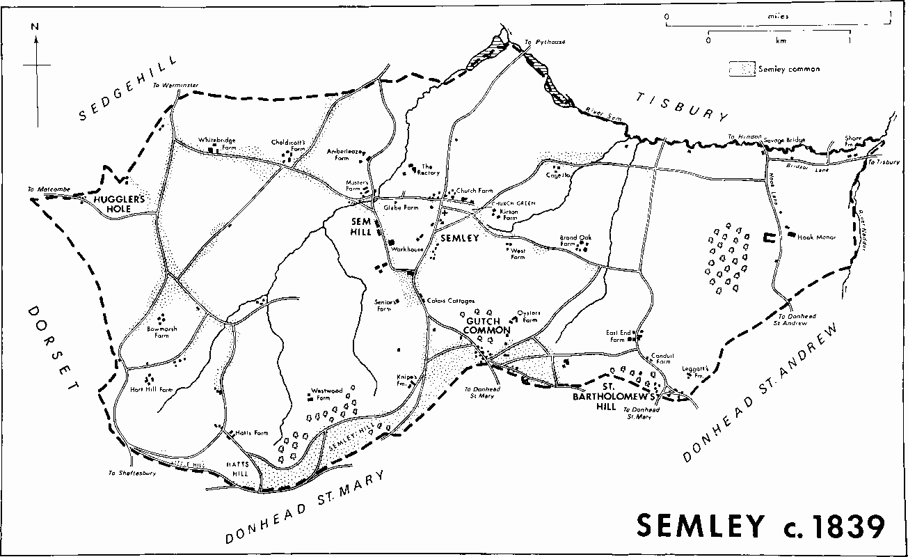
Semley c. 1839
Most of the two hamlets of Gutch Common and St. Bartholomew's Hill were in Semley but parts were in respectively Donhead St. Mary and Donhead St. Andrew. In the late 18th century as in the 20th the buildings of Gutch Common clustered around the junction of the Semley to Donhead St. Mary road and lanes running north-east and southeast. (fn. 37) A thatched cottage, perhaps of 17th-century origin, stands east of the junction; another, of the 18th century, is at the hamlet's northern end. Most other cottages to survive are stone and of the early 19th century. Two pairs of cottages were built north of the junction in the late 19th century; several bungalows were built in the later 20th.
The cottages of St. Bartholomew's Hill stood in 1773 and in 1985 around and within a triangle formed by the junction of lanes from Donhead St. Mary and Donhead St. Andrew. The hamlet, apparently called Bartholomew's Hill in 1773, (fn. 38) is possibly on a site called Barker in the later 11th century and in 1241. (fn. 39) The prefix 'St.' had been adopted by 1886, (fn. 40) but the hamlet was sometimes called Barker's Hill in the late 19th century (fn. 41) and the late 20th. Most buildings in the hamlet are small cottages of the late 18th century or the early 19th. Some were extended in the late 19th century, others in the late 20th. A nonconformist chapel was built in the hamlet in the later 19th century; (fn. 42) two houses were built there in the late 20th.
A settlement, called Sem Hill in the late 19th century, (fn. 43) grew up on rising ground north and south of the Sem and of the road leading west from Semley church. The principal buildings there in 1773 were Musters Farm and Amberleaze Farm, (fn. 44) both long established farmsteads north of the road. The farmhouse of Musters, of 17th-century origin, was refronted in the 19th century, and that of Amberleaze was rebuilt in the late 19th century. By 1811 cottages had been built south of the road. (fn. 45) Some had been demolished by 1839 but there were then several buildings, including the workhouse, beside a lane leading south from the road. (fn. 46) The workhouse, originally shaped as an E, without the central bar, was later extended northwards between the wings; in 1985 it was rendered and was being further altered as a private house. From 1859 the hamlet was divided by the railway line which was carried northeast and south-west through it on a bank and by a bridge over the road. In the mid or late 19th century a large house called Grove House was built north of Musters Farm and cottages were built west of the lane and another cottage beside the railway north of the road. Two terraces, each of four council houses, built west of the lane in the 1920s, (fn. 47) and the village hall, west of the railway bridge, were among the few 20th-century additions to the hamlet.
Semley station was served by a new road, later called Station Road, which ran along the north side of the railway and linked the Warminster—Shaftesbury road with that leading west from Semley church. (fn. 48) Soon after the station was opened two brick cottages, called Porters Cottages, were built beside the Warminster—Shaftesbury road. The Railway hotel, north of Station Road, was open in 1865, and was known from 1935 as the Kingsettle hotel. (fn. 49) A late 19th-century house east of it was part of a milk depot opened c. 1871. A factory, incorporating the house, was built for processing milk in the early 20th century. (fn. 50) Cottages for workers at the depot were built 100 m. east of it in the late 19th century and between it and the hotel in the early 20th. Those east of the depot were called Dairy Cottages. North-east of them four pairs of council houses were built in the 1930s. The Kingsettle estate, 14 council houses completed in 1955, (fn. 51) and workshops were built at the west end of Station Road.
Settlement in the parish west of the WarminsterShaftesbury road consists of a few scattered cottages and Huggler's Hole, a hamlet which extends into the former Sedgehill parish. The Semley part of the hamlet contains six houses and bungalows built in the 19th century and the late 20th.
Beside the Pythouse road north of Semley village are traces of what may have been a medieval moat. (fn. 52) No building stood near the site in the late 18th century but Brickkiln Cottage was built west of it in the late 19th. (fn. 53) In 1773 there were c. 20 farmsteads scattered throughout the parish, in addition to those in the village and the hamlets. (fn. 54) Most probably occupied sites which had long been in use. The oldest surviving buildings are in the east part of the parish. East End Farm comprises a single north—south range, probably of the late 16th century, the date of stone mullions of ground-floor windows which have been replaced. (fn. 55) Its plan, perhaps of three rooms, was unusual, having a single doorway at the north end of the main east front and at its southern end a pair of adjacent doorways protected by a porch. The inside of the house was altered and the windows renewed c. 1970, (fn. 56) when brick outbuildings were incorporated with the house on its north side and ranges of loose boxes were built east of the house to form a courtyard. Hook Manor and the farmhouse west of it are of the 17th century. Surviving 18th-century houses include Conduit Farm, Leggatt's Farm, and Hatts Farm. Another, east of East End Farm, was an inn called the Butchers' Arms in 1886. (fn. 57) Some farmsteads went out of use in the 19th century. South of Kirton Farm, West Farm, so called in 1773, (fn. 58) had been replaced by Westhayes Cottage by 1886. (fn. 59) Cage House, north of Kirton Farm, may also have been a farmstead and was demolished between 1839 and 1886. (fn. 60) Oysters Farm, on a site in use in 1773, was no longer a farmhouse in 1985, but the farm buildings were then still in use. Other farmsteads were built on new sites in the late 18th century and the early 19th. The Marshes and a farmstead for Bowmarsh farm were built between 1773 and 1811; (fn. 61) that for Bowmarsh farm was replaced by a large house and farm buildings in 1856. (fn. 62) Houses or cottages built between 1811 and 1839 on the sites of Westwood Farm, south-west of the church, and Glebe Farm, west of the church, (fn. 63) were replaced by new farmsteads respectively in the 1850s and 1860s. (fn. 64) Farmsteads on Share, Seniors, Broad Oak, Knipes, Hart Hill, and Whitebridge farms were also rebuilt in the 19th century; Whitebridge Farm, a large redbrick house, bears the date 1865. At Chaldicotts Farm new farm buildings, cottages, and a brick farmhouse were built in the late 19th or early 20th century. Other 20th-century buildings, outside the village and hamlets, include several farm cottages, bungalows near Broad Oak Farm and Bowmarsh Farm, and houses north of East End Farm.
Manors and other Estates.
Lands at Semley were apparently part of the estate of 100 mansiunculae (small dwellings) called Chalke when it was given by King Edwy to Wilton abbey in 955. (fn. 65) The manor of SEMLEY belonged to the abbey until the Dissolution when it passed to the Crown. In 1541 it was granted in tail to Sir Edward Baynton (d. 1544) and his wife Isabel, (fn. 66) who in 1564 conveyed it to their son Francis. (fn. 67) In 1572 he restored Semley to the Crown; (fn. 68) in the same year the manor was granted to Matthew Arundell, (fn. 69) knighted in 1574. Sir Matthew was succeeded in 1598 by his son Thomas (cr. Baron Arundell of Wardour in 1605, d. 1639). (fn. 70) In 1633 Thomas conveyed the manor to trustees, (fn. 71) probably of his daughter Anne and her husband Cecil Calvert, Baron Baltimore, (fn. 72) of whom the manor was said to be held in 1638. (fn. 73) In 1642 Arundell's son Thomas, Baron Arundell, successfully challenged Baltimore's title to the manor. (fn. 74) Baltimore continued nevertheless to hold the manor house and some lands, and in or before 1647 he, as a papist, suffered sequestration of those and other estates. (fn. 75) In 1647 the manor was also among the sequestrated estates of Henry, Baron Arundell, who had succeeded his father Thomas in 1643. (fn. 76) The sequestrators required a new trial to be made of the title; (fn. 77) judgement was given in 1649 that the manor had been Arundell's at the time of sequestration. (fn. 78) In 1653 Semley manor was among lands sold by the state to trustees of Henry, Baron Arundell. (fn. 79) It passed with Wardour castle in Tisbury and the Arundell title to James, Baron Arundell (d. 1834). (fn. 80) Between 1806 and 1820 c. 800 a. of the manor were sold, (fn. 81) and in 1839 the Wardour estate included c. 550 a. in Semley. (fn. 82) That land and the lordship of the manor remained part of the Wardour estate until 1946; they then passed in turn to R. J. A. Arundell (d. 1953) and his son Mr. R. J. R. Arundell, (fn. 83) who owned 440 a. in Semley in 1985. (fn. 84) In 1962 Mr. Arundell sold Leggatt's farm, 114 a.; Mr. D. B. Pitman owned the farm in 1985. (fn. 85)
Hook Manor, built of stone from a quarry in Tisbury parish in 1636–7, (fn. 86) is of two storeys and attics on a half-H plan with its wings to the south. (fn. 87) The north and south elevations are symmetrical; the centrepiece of the southern elevation is the entrance, that of the northern elevation is the hall chimney stack. The opposition of door and chimney in the hall suggests a break from the usual early 17th century plan in which there was an entry passage, but later alterations have obscured the original plan. A south porch was added, perhaps in 1655, (fn. 88) and by 1815 the hall had been divided into a smaller room and two passages. (fn. 89) The house was extensively restored to designs of T. L. Dale in 1935. (fn. 90) The hall and a room east of it were then made one, a new staircase was built, the porch and a small room east of it were removed, and a service wing was added at the house's north-western corner. A moulded plaster ceiling in the south-east ground-floor room bears the initials of Cecil, Lord Baltimore, and Anne his wife and decoration, including whales and ships, said to represent the Ark and the Dove which carried colonists to Maryland in 1633. (fn. 91)
John Benett of Pythouse bought a total of 441 a. of Semley manor, 147 a. in 1806, 206 a. in 1808, and 88 a. in 1820. (fn. 92) In 1839 his estate in Semley comprised 1,064 a. By 1847 c. 350 a. of the lands bought from the Arundells had been sold. (fn. 93) The remainder passed after Benett's death in 1852 in turn to his grandsons John Benett (d. 1856) and Vere Fane, who took the additional surnames Benett, in 1856, and Stanford, in 1868 after his marriage to Ellen Stanford. After Vere's death in 1894 (fn. 94) the lands were held by Ellen, from 1897 wife of Charles Thomas, who took the additional surname Stanford, was created a baronet in 1929, and died in 1932. After Ellen's death in 1932 the lands passed in turn to her son John Fane-Benett-Stanford (d. 1947) (fn. 95) and to trustees for his relict Evelyn. The trustees sold Glebe farm, c. 70 a., in 1952 to F. C. Goodall, and 55 a. in 1952 and Amberleaze farm, 56 a., in 1959 to H. F. Dunford and his wife Phyllis, who bought Glebe farm, then 52 a., from Goodall in 1956. Dunford (d. 1976) was succeeded by his son Mr. L. G. J. Dunford, who held c. 180 a. in Semley in 1985. (fn. 96) After Evelyn Fane-Benett-Stanford's death in 1957 Kirton farm, c. 90 a., was inherited by Sir (Horace) Anthony Rumbold, Bt., a kinsman of Vere FaneBenett-Stanford. In 1959 Sir Anthony sold the farm to L. R. Brice (fn. 97) (d. 1964), whose relict Mrs. P. M. Brice (fn. 98) sold it in 1983 to Barbara, comtesse de Bryc, the owner in 1985. (fn. 99)
In 1847 John Benett sold West wood farm, c. 100 a., to Richard Grosvenor, marquess of Westminster. Richard had already bought from Benett Hart Hill farm and Bowmarsh farm, totalling c. 250 a. The three farms had formerly been parts of Semley manor. (fn. 100) On Richard's death in 1869 the farms passed to his relict Elizabeth, with remainder to his daughter Octavia. Elizabeth probably sold her life interest in the lands in Semley with her interest in the Fonthill Abbey estate to Octavia's husband Sir Michael Shaw-Stewart, Bt., between 1878 and 1884. (fn. 101) Shaw-Stewart (d. 1903) apparently held the Semley lands in 1885, and they passed in turn to Octavia (d. 1921) and her son Walter ShawStewart, (fn. 102) who owned a total of 850 a. in Semley. Between 1924 and 1927 he sold c. 250 a., including Westwood farm and part of Bowmarsh farm. By 1927 Westwood farm, c. 140 a., had been bought by C. E. Lambe (fn. 103) (fl. 1950). (fn. 104) Lambe was succeeded by J. L. Lambe who in 1976 sold the farm, then 105 a., to Mr. and Mrs. B. Ellis, the owners in 1985. (fn. 105) Lands probably bought from Walter Shaw-Stewart and still called Bowmarsh were sold as a farm of 90 a. by J. Stevens-Moore in 1927. (fn. 106) In 1940 J. P. Sherwood sold Bowmarsh farm, 140 a. (fn. 107) The lands were later dispersed. (fn. 108) On Walter Shaw-Stewart's death in 1934 Hart Hill farm passed to his relict Mary. (fn. 109) She sold it in 1936 (fn. 110) to S. J. Young, who was succeeded by his son Henry in or after 1939. In 1968 Henry sold the farm, 150 a., to Mr. N. J. Dent, the owner in 1985. (fn. 111)
In 1806 Henry, Baron Arundell, sold Broad Oak farm, 58 a., to James Bracher. (fn. 112) In 1839 it belonged to William Bracher (fn. 113) (fl. 1848). The farm was held in 1859 by Henry Bracher, in 1875 and 1889 by Thomas Bracher, (fn. 114) and in 1910 by Elizabeth Bracher (d. 1914). E. A. Wightwick held it in 1927 (fn. 115) and 1939. (fn. 116) In 1967 the farmhouse and 6 a. were bought by Mr. Julian Bream, the guitarist and lutenist; the remaining lands were bought then or earlier by L. W. G. Hunt, who sold them in 1974 to Mrs. Barbara Fane, later comtesse de Brye, the owner in 1985. (fn. 117)
Lands sold by the Arundells between 1806 and 1808 included 112 a. to George Parham, 104 a. to William Rixen, and 61 a. to John Phelps. (fn. 118) The later history of Rixen's and Phelps's holdings has not been traced. Parham's purchases probably included two farms, of c. 40 a. each, called the MARSHES and KNIPES, which passed on his death in 1826 to Robert Barfoot (fl. 1839), perhaps his kinsman. (fn. 119) Members of the Barfoot family owned the farms until 1903 (fn. 120) when they were bought probably by Frederick Pike who held them in 1910. (fn. 121) In 1920, after Pike's death, the farms were sold. (fn. 122) The Marshes was owned in 1923 by R. Borley and others, in 1927 by W. Board, (fn. 123) and in 1939 probably by S. Board, (fn. 124) who sold the farm in 1956. In 1962 A. I. Jukes sold the Marshes as a farm of 39 a. (fn. 125) Knipes farm was owned in 1923 and 1927 by W. Nutbeen, (fn. 126) in 1939 probably by S. Nutbeen. (fn. 127) In 1946 it was bought by S. A. Godeseth, who in 1983 sold it as a farm of 43 a. to Mr. A. W. Godeseth, the owner in 1985. (fn. 128)
In 1330 Richard of Trow conveyed to William de Northo and his wife Christian lands in Semley and the reversion of others there or in Pertwood held for life by Richard's sister Joan. (fn. 129) The lands in Semley may have been those settled on Roger Manningford in 1379 (fn. 130) and held by William Orchard in 1412, (fn. 131) and perhaps comprised all or part of the manor of NORTHOUSE or Northouse Court conveyed by William Ames to John Gilbert in 1566. (fn. 132) By 1580 the lands of the manor had been divided and sold. Some, possibly including the manor house and demesne lands, were held in 1580 by Thomas Benett. (fn. 133) At his death in 1591, however, Thomas held only a tenement and 16 a. in Semley; they passed to his son Thomas (fn. 134) (d. 1635). (fn. 135) Christopher Benett (d. 1636) held the demesne lands of Northouse and was succeeded by his son Thomas. (fn. 136) In 1645 and 1653 the lands were apparently held by Thomas Benett, son of Thomas (d. 1635). (fn. 137) He died in 1663. (fn. 138) A Thomas Benett held the lands in 1668 (fn. 139) and sold those or other lands in Semley in 1688 to John Pettredge (fn. 140) (fl. 1711). (fn. 141) The lands, perhaps 69 a. in 1769, (fn. 142) passed in several families until 1792 when they were bought by Thomas Benett of Pythouse (fn. 143) (d. 1797). They were inherited by Thomas's son John (fn. 144) and became part of the Pythouse estate.
Lands formerly part of Northouse manor and later said to comprise c. 60 a. (fn. 145) were bought in or before 1668 from the Revd. Martin Clarke by Bartholomew Lane (fn. 146) (d. 1679). His estate passed in moieties to his daughters Susanna, wife of Robert Coker, and Magdalen, wife of William Okeden. (fn. 147) The Cokers were succeeded by their son Robert Coker, on whose death in 1713 the moiety passed to his cousin William Coker. William sold it in 1737 to Matthew Frampton (d. 1742). Under Frampton's will it passed with a moiety of Great Linley in Tisbury in turn to his nephews the Revd. Thomas Bull (d. 1743), Edward Polhill (d. 1759), and Edward's brother Simon (d. 1760), and to another kinsman the Revd. William Bowles (d. 1788), whose son William (fn. 148) sold it, probably in 1808, to John Benett. (fn. 149) The other moiety passed from Magdalen (d. 1688) and William Okeden (d. 1718) to their daughter Mary (d. 1719), wife of William Glisson. It was inherited by the Glissons' daughters Mary, wife of John Gould, and Magdalen, wife of the Revd. Conyers Place. In 1745 they sold the moiety, probably to Edward Polhill. (fn. 150) The moieties were apparently thereafter united. Those and the other lands derived from Northouse manor which passed with the Pythouse estate may have been among lands sold by the trustees of Evelyn Fane-Benett-Stanford in 1952; the holding of 55 a. then bought by H. F. Dunford and his wife Phyllis may have derived from Northouse. Some of the lands may have been part of Church farm, 276 a., sold in 1973 by Sir Anthony Rumbold, Bt., to Barbara, comtesse de Brye. (fn. 151)
A third portion of Northouse manor was held in 1580 and 1589 by John Ames, (fn. 152) in 1598 and 1611 by William Senior, (fn. 153) and c. 1639 by Thomas Senior. (fn. 154) The lands apparently passed to members of the Knipe family. William Knipe held 54 a., including Seniors farm, in 1769. (fn. 155) A William Knipe was succeeded by his brother Edward in 1799. Edward (d. 1821) devised Seniors farm to his relict Elizabeth and for sale on her death. (fn. 156) It passed, presumably by sale, to George Parham (d. 1826) (fn. 157) and thereafter with Knipes farm and the Marshes in the Barfoot family and to Frederick Pike (d. by 1920). It was probably sold with Pike's other holdings in 1920, (fn. 158) and in 1923, as a farm of 56 a., belonged to Arthur Hiscock. In 1927 it belonged to Mrs. M. B. Ciberne. (fn. 159) H. B. Ciberne held it in 1935, and c. 1939 it was bought by Donald Handley. By 1944 it had passed to H. Wort; Mrs. M. L. Wort held the farm in 1950, and in 1955 sold it to Maj. O. Patch, the owner in 1985. (fn. 160)
An estate in Semley later called CHALDICOTTS was probably that held in 1212 by Philip Chaldicott (fn. 161) and may have belonged to Walter Chaldicott (fl. 1305). (fn. 162) In 1343 John Chaldicott settled part of the estate on himself and his wife Cecily and part on his son Thomas and Thomas's wife Edith. (fn. 163) The estate may have passed to William Chaldicott (fl. 1362), (fn. 164) and in 1448 was settled on Richard Chaldicott and his wife Joan. (fn. 165) Richard was succeeded in turn by his son William (d. 1483) and William's son George (fn. 166) (d. by 1559). The estate passed to George's illegitimate son William Chaldicott (d. 1584). (fn. 167) William was succeeded by his daughter Edith who married her cousin Francis Chaldicott (fn. 168) (d. 1636). (fn. 169) On Edith's death in 1638 the estate was divided. Lands called Chaldicotts, Moors, and Musters passed to her granddaughter Jane Chaldicott (fn. 170) but in 1645 were held by Jane's uncle William Chaldicott. In 1666 William sold Musters and perhaps Moors to John Nicholas or Nicholls. (fn. 171) They were both held in 1711 and 1736 by Edward Nicholas or Nicholls (fn. 172) but thereafter passed separately. Musters, a farm of c. 50 a., was held in 1748 by Thomas Pike, a kinsman of Edward Nicholas or Nicholls, (fn. 173) and in 1769 and 1801 by Robert Cooper. (fn. 174) Robert Brown held Musters in 1831 (fn. 175) and 1839. (fn. 176) Perhaps by 1875 and certainly by 1888 the farm had been bought by Frederick Pike (fn. 177) (d. by 1920). It was sold with Seniors farm and Knipes farm in 1920, (fn. 178) probably to C. E. Lambe who in 1950 sold it to J. Snook. In 1964 Snook sold Musters farmhouse and c. 25 a. and Miss R. A. Bradshaw sold c. 20 a., formerly part of the farm. The larger holding was bought by Mr. D. Ford, who sold it in smaller portions; Mr. E. M. Sanders bought the house and a few acres in 1966 and held them in 1985. H. F. Dunford and his wife Phyllis bought the 20-a. holding in 1964; it passed with Glebe farm to Mr. L. G. J. Dunford. (fn. 179)
Between 1711 and 1736 Chaldicotts passed in the Plowman family. (fn. 180) In 1748 and 1801 it and Moors, c. 50 a. each, were held together by members of the Shirley family. (fn. 181) In 1839 Chaldicotts, a farm of 145 a. perhaps including Moors, was held by Henry Hetley and Richard Hetley. (fn. 182) In 1910 it belonged to Lady Octavia Shaw-Stewart. (fn. 183) It passed with Hart Hill farm to Mary Shaw-Stewart, who sold it in 1936 (fn. 184) to Jesse Sage. His daughter Mrs. Kitty James conveyed the farm c. 1965 to her sons Mr. Arthur James and Mr. Ralph James, who owned Chaldicotts, 172 a., in 1985. (fn. 185)
Another part of Edith Chaldicott's estate in Semley, including farms called Salmons place and Hatts, passed at her death in 1638 to her son Andrew Chaldicott (fn. 186) (d. 1641), who was succeeded by his daughter Catherine. (fn. 187). In 1645 the farms were held by Thomas Grove, (fn. 188) who sold them c. 1654 to William Joyce (fn. 189) (fl. 1668). (fn. 190) By 1711 Hatts, c. 100 a., had passed to Nicholas Joyce (fn. 191) (fl. 1748). (fn. 192) In 1769 it was held by John Dalton (fn. 193) (fl. 1801). (fn. 194) After the death in 1826 of Dalton's son Nathaniel, Hatts was bought by John Benett, (fn. 195) who sold it in 1847 to Richard, marquess of Westminster. (fn. 196) It passed with Hart Hill farm to Mary Shaw-Stewart, who sold Hatts farm, 128 a., in 1936 (fn. 197) to Jesse Sage. In 1976 Sage's sons Edmund and Bertram sold 97 a. to Mr. J. S. Asbury and 30 a. to Mr. R. F. C. Isgar; Mr. Asbury and Mr. Isgar owned the lands in 1985. (fn. 198)
Salmons place was held in 1696 by Robert Hyde (fn. 199) (d. 1722) and passed, later in moieties, with West Hatch manor in Tisbury in the Hyde and Parker families. A moiety, like a moiety of West Hatch manor, belonged to Sir John Dillon (d. c. 1837) and was probably bought with the lands of West Hatch in 1837 by John Benett. The second moiety was probably, like the second moiety of West Hatch manor, bought by Benett from Sir Hyde Parker, Bt., in 1841. As part of the Pythouse estate the farm, then called East End farm, passed to Sir Anthony Rumbold, Bt. (fn. 200) In 1967 he sold it as a farm of 104 a. (fn. 201) In 1974 most of the land was sold, probably by A. E. C. Pitman, to Barbara, comtesse de Brye, the owner in 1985. (fn. 202)
Roger Atcliffe settled lands in Semley, possibly the later CHURCH GREEN farm, on John Atcliffe in 1325. (fn. 203) Roger Atcliffe, presumably another, conveyed them in 1352 to Thomas Virgo, (fn. 204) who in 1365 granted them to John Gawen and his wife Edith. (fn. 205) Laurence Gawen held the lands in 1420–1. (fn. 206) They passed in the Gawen family, perhaps with Norrington manor in Alvediston, and in 1572 were held by Alice, relict of William Gawen (d. 1559). (fn. 207) Elizabeth Gawen held them in 1580 (fn. 208) and 1589. (fn. 209) By 1592 the lands had passed to Thomas Gawen, who as a papist suffered sequestration of two thirds of them. (fn. 210) Thomas (d. 1604) was succeeded by his son Thomas, (fn. 211) who sold the lands before 1623 to Richard Thomas. (fn. 212) From Richard they passed after 1638 by inheritance to Anthony Benett (fn. 213) (fl. 1660). (fn. 214) The lands may have been those held in 1736 by William Waller (fn. 215) and in 1748 by Thomas Powell. (fn. 216) In 1769 Powell or a namesake held an estate of c. 140 a., including Church Green farm, (fn. 217) which by will dated 1773 he gave to his son Adam. (fn. 218) The farm was held by Adam in 1801; (fn. 219) by 1832 all or part of it had been sold to John Benett. (fn. 220) Church Green, later Church, farm passed as part of the Pythouse estate to Sir Anthony Rumbold, Bt., who sold it in 1973 as a farm of 276 a. to Barbara, comtesse de Brye. In 1985 she owned c. 600 a. in Semley, including Church farm. (fn. 221)
Church Farm has a low east-west principal range of the late 16th century or the early 17th which is entered by a cross passage with an elaborately panelled early 17th-century screen. A panelled cupboard beside the hall chimney stack, east of the passage, has small openings in two sides and is said to have been used as a confessional. A three-storeyed parlour wing with a square bay window was added east of the hall in the early 17th century. It contains some original panelling and two 18th-century fireplaces.
Lands, possibly including those later called ANSELLS and OYSTERS, were conveyed in 1346 by Robert of Littleton to John of Ashurst and his wife Maud. (fn. 222) The lands passed to John's daughter Isabel and in 1445 were claimed by her great-greatgranddaughter Margaret Burdon. (fn. 223) They were held in 1517–18 and 1545 by John Burdon (fn. 224) and in 1549– 50 were granted by his son Walter to Catherine Turney and her sister Alice. (fn. 225) The lands may then have been divided, perhaps between the sisters. A holding, said formerly to have belonged to the Turney family and perhaps Alice's portion, was conveyed in 1572 by Sir John Thynne and his wife Dorothy to Thomas Gifford and his son John. (fn. 226) That holding, then called Ansells, belonged to John Gifford in 1598 (fn. 227) and at his death in 1601. He was succeeded in turn by his son William (fn. 228) (fl. c. 1639) (fn. 229) and by John Gifford (fl. 1645); (fn. 230) nothing is known of Ansells thereafter. Lands belonging to Catherine Turney formed an estate called Oysters which was held in 1580 by her husband William Webb. William (d. by 1585) (fn. 231) was succeeded in turn by his son Sir William (d. 1627), (fn. 232) and by Sir William's daughter Rachel, wife of Sir John Coke, (fn. 233) who held Oysters in 1663 and by 1668 had sold it to Sir Thomas Turner. (fn. 234) It was held by George Kingsye in 1711, (fn. 235) and by Thomas Trevor, Baron Trevor, in 1736. (fn. 236) Robert Pinkney, who may have bought the estate from Trevor in 1736, (fn. 237) held it in 1748. (fn. 238) He or another sold it to Henry, Baron Arundell (d. 1756). (fn. 239) It passed with Semley manor until 1806, (fn. 240) was then or later, like lands of the manor, bought by John Benett, (fn. 241) and passed as part of the Pythouse estate to trustees for Evelyn Fane-Benett-Stanford, who sold Oysters farm, 113 a., c. 1950. In 1952 it was bought by Mr. A. E. Flower, who owned it in 1985. (fn. 242)
In 1558–9 William Gray held an estate called CALLIS place. (fn. 243) Lands perhaps formerly part of the estate may have been held in 1572 by James Mervyn (fn. 244) (knighted in 1574, d. 1611). They passed, apparently with Fonthill Gifford manor, to Mervyn Tuchet, earl of Castlehaven, (fn. 245) who in 1623 sold Callis place to Thomas Benett of Pythouse. In 1631 Benett granted the lands to his third son William (d. 1661), who devised them to his wife Agnes for her life. On her death they passed in turn to her sons Thomas (d. 1667) and William Benett (d. 1712). William was succeeded by his son William (d. 1729), whose daughter-in-law Parthenia Benett (fn. 246) held the lands as Callis farm, 41 a., in 1769. (fn. 247) The farm apparently passed to the younger William's son John (d. 1772), after whose death it was bought by Thomas Benett of Pythouse. (fn. 248) Thereafter it was part of the Pythouse estate. Lands formerly of Callis place may have been among those of Oysters farm, sold by trustees of Evelyn Fane-Benett-Stanford c. 1950. (fn. 249)
Lands perhaps formerly part of Callis place and later called WHITEBRIDGE farm were held in 1580 by John Gray and in 1582 by Robert Baron (fn. 250) (fl. 1613). (fn. 251) William Brown held the farm in 1617 (fn. 252) and 1661, (fn. 253) as did Isaac Blandford in 1698. (fn. 254) John Blandford may have owned it in 1736, (fn. 255) as he did in 1748. (fn. 256) It passed by sale or inheritance to William Hacker (fl. 1781), (fn. 257) who conveyed it before his death in 1809 to his nephew John Rogers. By 1829 John had been succeeded by his son John, (fn. 258) who held Whitebridge farm, 133 a., in 1839. (fn. 259) John died in 1844 and the farm was sold in 1865. (fn. 260) It was later among the lands of Walter Shaw-Stewart, (fn. 261) who sold it in 1928 to W. S. Pike as a farm of 150 a., including c. 80 a. in Semley. Pike was succeeded in 1947 by his son Mr. Donald Pike, who sold the farm in 1956 to Blackford Hickman. It was bought in 1968 by D. J. Child. In 1985 the farmhouse and 11 a. in Semley were owned by Mr. G. R. D. Letts, 40 a. in Semley by Mr. Gordon Curtis, and c. 90 a. in Semley and neighbouring parishes by Cmdr. J. M. Child. (fn. 262)
A pension, said formerly to have been due to Wilton abbey from Semley rectory, was granted with other estates of the dissolved abbey to Sir William Herbert (cr. earl of Pembroke in 1551) and his wife Anne in 1544. (fn. 263) No later reference to the payment of the pension to earls of Pembroke has been found.
Economic History.
Semley lies within the Wiltshire butter country, and its clay soils provide extensive pasture. The proportion of arable land has long been small, and there is little evidence of open fields. There may have been a South field (fn. 264) but its location and the names and whereabouts of other fields are unknown. In the mid 14th century some and in the late 16th most arable lay in closes. (fn. 265) The low lying pasture between Semley church and Sedgehill church was called Whitemarsh. That pasture, and the upland pasture on the watershed of the Sem and Nadder between Semley and the Donheads, was shared by Wilton abbey, the lord of Semley manor, and its tenants, and by Shaftesbury abbey, the lord of Sedgehill and Donhead manors, and its tenants. Intercommoning was ended by an agreement in 1241, and on the two areas of pasture new boundaries were fixed. (fn. 266) The parts of the pasture allotted to Semley were not inclosed, and in the late 16th century there were c. 800 a. of common pasture in the parish. The pasture, including some for sheep on the hills to the south, was shared by the lord, customary tenants, and some free tenants of Semley manor. (fn. 267) In 1668 sheep were stinted 'on the hill' at the rate of 40 for every yardland, and the manor court ordered that the number of beast leazes should be halved, presumably because of overgrazing. (fn. 268)
In 1225 stock and grain on the demesne of Semley manor was valued at £6 9s. 6d., approximately a tenth of the value of that on the whole manor. The stock included 18 oxen, 27 cows, and 2 young cattle. The demesne was then and in 1305 in hand. There were 38 tenants of the manor in 1225. Between them they had 73 oxen, 100 cows, 88 young cattle, and 107 sheep. Only five kept sheep. Two tenants each had movables valued at more than £2; one had 6 oxen, 6 cows, 5 young cattle, and 40 sheep, the largest flock, and the other had 6 oxen, 7 cows, 14 young cattle, and 12 sheep. (fn. 269) In 1340 the demesne farm was apparently in hand. As much as half the sheep-and-corn husbandry may have been practised on it, but most of the parish may have been devoted to other forms of agriculture. (fn. 270)
The demesne of Semley manor was leased, perhaps as one farm in 1535 and in three portions in 1581. (fn. 271) The largest portion was worked from Hook Farm in the east part of the parish and in 1599 comprised 240 a., including 188 a. of inclosed meadow and pasture. (fn. 272) Possibly in the 17th century and certainly in the 18th small parcels of land, formerly part of Hook farm, were leased separately. Hook farm measured 178 a. in 1769; (fn. 273) by 1796, when it measured 283 a., c. 50 a. each of woodland formerly in hand and of land formerly copyhold had been added to it. (fn. 274) The smaller portions of the demesne in 1581, Dawes Frowdes, 40 a., and Amberleaze, 60 a., (fn. 275) formed one farm in 1599, (fn. 276) two in 1645. (fn. 277) In 1769 Amberleaze farm comprised 84 a., worked from a farmstead west of the village. (fn. 278)
There were 23 copyholders of the manor sharing 708 a. and pasture rights in 1599. Three were yardlanders, 14 ½-yardlanders; each of the others held 12–17 a. of inclosed land. (fn. 279) By 1769 all copyholds had been converted to leaseholds and a greater proportion of each was several, much of the common pasture having by then been inclosed. Most holdings were still small. Apart from the tenant of Hook farm, 36 lessees then shared 1,300 a. and pasture for cattle on the remaining commons. Only one held more than 100 a., eight had farms of 50–100 a., and 17 had farms of 20–50 a. (fn. 280) By 1806 the number of leaseholds had been reduced to 25, but still only one exceeded 100 a. (fn. 281)
In addition to the demesne and copyholds of Semley manor, the main estates in the Middle Ages were Northouse, Chaldicotts, those later called Ansells and Oysters, possibly those later called Callis place and Whitebridge, and the rector's glebe. None seems likely to have included a farm of over 100 a., and most presumably included rights to feed animals on the common pastures. (fn. 282) In 1769 the farms derived from Chaldicotts were Chaldicotts, 132 a., Musters, 51 a., Hatts, 146 a., and East End, 153 a. Lands formerly part of Northouse manor then included a holding of 54 a. There were 13 other free holds in 1769; four were farms of 100–160 a., and five were farms of 40–70 a. (fn. 283) The glebe included 60 a. of arable, 20 a. of pasture, and 20 a. of wood in 1783. (fn. 284)
Between 1599 and 1769 c. 500 a. of pasture in the parish were inclosed. Most of the inclosed land may have been on the hills in the south where all the pastures for sheep, but not those for cattle, had been inclosed by 1769. Of the lowland pasture for cattle, nearly all that west of the Warminster—Shaftesbury road and nearly all that in the east had been inclosed by 1769. (fn. 285) In 1839, as in 1985, the remaining 300 a. of common pasture for cattle consisted of strips beside the Warminster—Shaftesbury road, beside other roads in the western part of the parish, and beside the lanes in the south part. (fn. 286) Of the 300 a., 40 a., providing pasture for 11 cows and presumably in the south-east corner of the parish, was known in 1769 as East End common and was for certain leaseholds of Semley manor. The remaining 260 a. provided pasture for 258 cattle; the freeholders had rights to feed 99, the leaseholders of Semley manor, excluding the tenant of Hook farm, had rights to feed 159. (fn. 287) Proposals were made in 1813 and 1836 to inclose the common pasture and convert all or part of it to arable (fn. 288) but they were not implemented. Until 1922 use of the common was regulated by Semley manor court. Thereafter a common master was appointed annually by those who had grazing rights. In 1922 there were rights to feed 245 cattle, shared by 20 landowners and farmers. (fn. 289) In 1977, to preserve rights on the commons, 21 landowners applied to Wiltshire county council to register rights to feed a total of 252 cattle. (fn. 290) The commons were, however, little used for grazing and no common master was appointed in 1985. (fn. 291)
In 1839 there were in Semley c. 1,450 a. of pasture including the commons, c. 1,000 a. of arable, and c. 200 a. of wood. The land was worked in compact farms from farmsteads scattered throughout the parish. The largest farm, Westwood, was of 230 a.; there were 9 others of over 100 a., 7 of 50–100 a., and 10 of 20–50 a. Most were dairy farms with a high proportion of pasture but Whitebridge farm, 170 a., and Chaldicotts farm, 221 a., both in the north-western part of the parish, included 76 a. and 111 a. of arable respectively. Hook farm, 154 a., included 16 a. of water meadows beside the Nadder. Westwood farm, which included 70 a. of woodland, and another 63 a. of woodland were in hand as part of the Pythouse estate; tenants worked most of the other farms. (fn. 292)
Small dairy farms remained characteristic of the parish in the late 19th century and the early 20th. A new farmstead built on Whitebridge farm in 1865 was designed for cheese-making. (fn. 293) By 1910 some of the smallest farms had been merged into larger farms. Only 2 of fewer than 50 a. then survived but none exceeded 260 a.; 12 farms were over 100 a., 7 between 50 a. and 100 a. (fn. 294) Church farm, c. 150 a. in the 1920s, (fn. 295) was worked with lands of neighbouring farms in the 1970s and 1980s. In 1985 it was the largest farm in the parish; it comprised c. 500 a. north, east, and south-east of Semley church and was worked from the farmstead near the church. A herd of 380 cows was kept and some feedstuffs were grown. (fn. 296) Hook farm, 266 a., was also principally a dairy farm, with some arable, in 1985. (fn. 297) There was some diversification on other farms in the late 20th century. In 1985 beef cattle and sheep were kept on Westwood farm, 105 a., (fn. 298) and there was intensive pig breeding at Whitebridge Farm. (fn. 299) Hart Hill farm, 150 a., the farmstead and 15 a. of East End farm, and part of Bowmarsh farm were stud farms. (fn. 300)
In 1831, of 145 families living in the parish, 127 were employed in agriculture and 14 in trades, crafts, or manufacturing. (fn. 301) About 1871 Thomas Kirby started a business of buying milk from local farms and, from a depot near Semley station, sending it to London for sale. The depot was the first in Wiltshire serving primarily the London market. Others were opened by Kirby in south Wiltshire and Dorset in the 1880s; (fn. 302) they traded in 1889 as Semley and Gillingham Dairies (fn. 303) and from 1890 as Salisbury, Semley, and Gillingham Dairies Co. Ltd. The company was acquired by United Dairies (Wholesale) Ltd. in 1920. (fn. 304) A factory had been built at Semley by 1924, (fn. 305) and in 1928 milk was pasteurised and stored and cheese made there. The cheese room was converted to an egg store in 1944. (fn. 306) In the 1950s and 1960s milk collected and cooled in the factory was carried by glass pipes over Station Road to rail tanks for transport to London. The factory had been closed by 1985. Buildings east of it were then used by St. Ivel Ltd., a subsidiary of Unigate, the successor to United Dairies, as a store for redundant equipment. (fn. 307)
In 1903 and 1911 there were three coal merchants in Semley, working presumably from the station. One was still trading, as J. Wescott & Sons, in 1939. (fn. 308) In the 1920s and 1930s a building near the station was used for storing and repairing farm machinery by the Southern Counties Agricultural Trading Society Ltd. (fn. 309) A business of car breaking and selling spare parts was begun c. 1940 by H. S. Langford on a site on Church Green. It was later moved, first to a site north of Station Road, and in 1946 to one south of the station, (fn. 310) where there was a workshop and scrapyard in 1985. There were then small engineering workshops at the west end of Station Road and the former United Dairies factory was being divided into smaller units for industrial use.
Local Government.
There was apparently never more than a single tithing in the parish. (fn. 311) Courts of Semley manor are recorded from 1580 to 1922. In the late 16th century and early 17th the courts were usually held in spring and autumn each year; some additional courts were held at other times. Later, courts were usually held annually. Until the 19th century the homage presented buildings, ditches, and roads in need of repair, and holdings which had become vacant. Tenurial business included admissions to copyholds and recording some conveyances of freeholds. In the 1580s courts ordered undertenants to enter bonds that they would not allow their families to become dependent on parish relief and occupiers of certain freeholds to use the lord of the manor's mill at Bridzor in Tisbury parish. In 1610 the tenant of Gawen's freehold was allowed access for his cattle across the lord's waste to the river near Billhay bridge, on condition that the freeholder maintained the bridge. Much of the courts' business throughout the period concerned the common pastures. Rulings were made on the extent of grazing rights, both generally and for particular holdings. Those who exceeded their rights were fined, and those who encroached on the common were ordered to remove buildings or fences. In the 20th century the courts had little business other than the regulation of the commons. In 1903 presentments were made of those who left rubbish there, and the occupier of Grove House was ordered to cover an open drain running across the common. No court was held after a common master was appointed in 1922. (fn. 312)
In the 1770s and 1780s c. £160 was spent yearly on poor relief in Semley. In the early 19th century the parish was the most highly rated in the hundred. By 1802–3 spending on the poor had increased to £297; permanent relief was then given to 71, occasional relief to 58. (fn. 313) A workhouse was built in the parish after 1811. (fn. 314) The cost of poor relief reached peaks of £1,391 in 1812–13, when 65 received permanent and 21 occasional relief, (fn. 315) and £1,242 in 1819. As in neighbouring parishes expenditure fell in the early 1820s, rose in 1829, (fn. 316) and fell again in the 1830s. Between 1833 and 1835 average annual expenditure on the poor in Semley was £669. The parish became part of Tisbury poor-law union in 1835 (fn. 317) and the workhouse was sold, probably in 1837. (fn. 318) In 1974 Semley became part of Salisbury district. (fn. 319)
Church.
There was a rector of Semley and presumably a church there c. 1191. (fn. 320) The rectory was united with the vicarage of Sedgehill in 1976, (fn. 321) and in 1985 the united benefice of East Knoyle, Semley, and Sedgehill was formed. (fn. 322)
Wilton abbey was patron of the church until the Dissolution; (fn. 323) the Crown presented in 1344 when there was no abbess. (fn. 324) In 1540 William Petre presented a rector by grant of a turn from the abbey. (fn. 325) The advowson passed to the Crown at the Dissolution and in 1541 was granted to Sir Edward Baynton and his wife Isabel. (fn. 326) It passed with Semley manor to Sir Matthew Arundell and his son Thomas, Baron Arundell. (fn. 327) Neither presented and both granted turns of the patronage. By such grants Nicholas Gray presented in 1591, Daniel Yard in 1627 (fn. 328) and 1641. (fn. 329) In 1639 Thomas conveyed the advowson to his son-in-law Cecil Calvert, Baron Baltimore, (fn. 330) who sold it in 1643 to George Barber. (fn. 331) George (d. 1662) was succeeded by his son Robert (fn. 332) who in 1686 conveyed the advowson to his son Robert. By a grant of a turn made in 1701 Walter Philipps presented a rector in 1708. (fn. 333) In 1717 Robert Barber, perhaps the grantee of 1686, sold the advowson to the dean and chapter of Christ Church, Oxford, (fn. 334) who were patrons thereafter. (fn. 335) The dean and chapter were patrons of the united benefice of Semley with Sedgehill formed in 1976, (fn. 336) and from 1985 shared the patronage of the united benefice of East Knoyle, Semley, and Sedgehill with the bishop of Salisbury. (fn. 337)
In 1291 the rectory was valued at £7, less than the average for a living in Chalke deanery. The valuation included pensions of 6s. 8d. each from the churches of Donhead St. Andrew and Donhead St. Mary. (fn. 338) The pensions were referred to in 1428 (fn. 339) but not later. In 1535, when the rector's income was £17, and c. 1830, when it was c. £440, the rectory was one of the more valuable in the deanery. (fn. 340)
In the early 17th century the rector received tithes from the whole parish except Hook farm; by then hay tithes from the farm had been replaced by a share of the hay cut from meadows called Wooddey mead and Parsons acre, and other tithes by an annual payment of £3. (fn. 341) In 1839 the rector's tithes, including those compounded, were valued at £516 and commuted. (fn. 342)
The rector had glebe valued at £2 in 1341. (fn. 343) In 1614 the glebe was estimated at 93½ a.; (fn. 344) in 1839 it was 101 a. (fn. 345) The rector sold 72 a. in 1928; (fn. 346) most of the remainder was sold in 1958. (fn. 347) A house stood on the glebe in 1614. (fn. 348) A new stone house, with four rooms on each of its two storeys, was built between 1735 and 1759, (fn. 349) and was extended in the late 18th century (fn. 350) and in 1857. (fn. 351) It was sold in 1958; (fn. 352) in 1959 a new rectory house was built. (fn. 353)
Although the living was not then rich, men of ability and influence were rectors of Semley in the later Middle Ages. Thomas de Rouen, rector 1305– 39, and Henry Wetherby, rector 1409–18, were licensed to study at Oxford or Cambridge while holding the rectory. (fn. 354) John Wotton, rector 1339– 44, (fn. 355) was clerk to the chapter of Salisbury cathedral. (fn. 356) Edward Willoughby, rector 1494–1508, was also from 1492 a canon of Exeter cathedral and from 1500 dean. (fn. 357) In 1553 the rector, John Wrenche, was presented for omitting some quarterly sermons; in 1585 it was reported that he did not catechize every Sunday and that his curate did not say daily services. A copy of Erasmus's Paraphrases, held by the church in 1553, was missing in 1565. (fn. 358) Henry Leigh was sequestrated from the rectory, (fn. 359) probably in 1645 when John Noake, 'a painful preacher', was appointed to serve the parish as a stipendiary minister. (fn. 360) Leigh's successor as rector, Robert Haysome, had already suffered sequestration of Minstead rectory (Hants) when he was appointed to Semley in 1646. Following reports that he had spoken against parliamentary leaders and in favour of Archbishop Laud he was removed from Semley in 1647. (fn. 361) Matthew Toogood, who became rector in 1647, signed the Concurrent Testimony in 1648 (fn. 362) and was commended as a diligent preacher in 1650; (fn. 363) he resigned or was ejected in 1661. Robert Haysome may have been restored to the rectory in 1661, (fn. 364) but if so had been replaced by 1662. (fn. 365) Most 18th-century rectors were pluralists but few held other parochial cures. David Gregory, rector 1735–59, was a canon of Christ Church from 1736 and dean from 1756. Peter Foulkes, rector 1759–78, was a canon of Exeter. (fn. 366) In the mid and late 18th century communion was celebrated four times a year. In 1783 there were usually 20–30 communicants. A morning service with a sermon and an afternoon service were held on Sundays; there were additional services only at festivals. (fn. 367) On Census Sunday in 1851 a congregation of 70 people attended the morning service; 80 people attended the afternoon service. The numbers were said to be much smaller than usual. (fn. 368) In 1864 the average congregation was said to number 180. Services were then held twice on Sundays and additionally in Lent and Holy Week. Communion was celebrated at the great festivals and monthly; (fn. 369) in 1868 it was celebrated twice a month. (fn. 370)
The church of ST. LEONARD was so called in 1763. (fn. 371) In the early 19th century it consisted of a chancel with south chapel, a nave with north porch and south aisle, and a west tower. The chancel was probably of the 13th century and the nave and the tower were perhaps of the 14th. The chapel and aisle may have been added in the 15th century when many windows in other parts of the church were renewed. (fn. 372) The church was restored in 1846, (fn. 373) and in 1866 the chancel was rebuilt to designs by T. H. Wyatt. (fn. 374) In 1874–5 the church was demolished, except for the chancel, which was incorporated in a new building designed by Wyatt in Perpendicular style. (fn. 375) That church is of ashlar and has a chancel, an aisled nave, and a tall west tower, whose stair turret is surmounted by a spire. A late 13th-century effigy of a priest, from the north porch of the old church, has been reset in the church. (fn. 376)
Before 1783 2 a. in Tisbury were given for the repair of Semley church, possibly by a member of the Benett family, on condition that inhabitants of the west part of Tisbury parish be allowed seats in the church. In 1783 the land was let for £1 15s., in 1906 for £2 15s. (fn. 377) In 1985 the income was used for maintenance. (fn. 378)
In 1553 plate weighing 12 oz. was confiscated from Semley; a chalice of 7 oz. was left in the church. (fn. 379) In 1783 the parish had a chalice, paten, and flagon, all of silver. (fn. 380) The paten still belonged to the church in 1985; the chalice and flagon were sold in 1874. A new chalice, bought in 1874, another, of the late 15th or the early 16th century, given to the parish in the late 19th century, and a third, given in 1944, were among other vessels held by the church in 1985. (fn. 381)
Four bells hung in the church in 1553. One, of c. 1410 by Robert Burford of London, hung in the new church in 1985. A bell of 1733 by William Cockey of Bristol replaced or was recast from another. Bells recast into four by Mears & Stainbank in 1878 may have been the other two. Those six bells hung in the church in 1985. (fn. 382)
Registers of burials are complete from 1708, those of marriages and baptisms from 1709. (fn. 383)
Nonconformity.
William Browne of Semley, who stood excommunicate in 1585, was a convicted recusant in 1593. Another parishioner, presented in 1585 for attending church irregularly, may also have been a papist. (fn. 384) In the 17th century and later Roman Catholicism survived in Semley, as in neighbouring parishes, chiefly through the influence of the Arundell family. (fn. 385) A convicted recusant is recorded in Semley in 1629, (fn. 386) and between 1645 and 1654 two inhabitants of the parish, Cecil, Baron Baltimore, who claimed the lordship of the manor, and William Knipe, suffered sequestration of their estates as papists. (fn. 387) Five papists were presented in 1662, (fn. 388) and 10 lived in the parish in 1676. (fn. 389) There were 39 in 1767, and in 1780 the figure of 43 was the fourth highest for a Wiltshire parish. (fn. 390) The descendants of William Knipe (fl. 1654) remained Roman Catholics until the early 19th century; the house which they occupied, Knipes Farm, was said to have contained a chapel. (fn. 391) Other Roman Catholics living in the parish presumably heard mass at Wardour and at the chapel at St. Bartholomew's Hill which was built within Donhead St. Andrew parish in 1887. (fn. 392)
Matthew Toogood, formerly rector of Semley, was ejected from Hilperton rectory in 1662 and returned to Semley to preach and teach. (fn. 393) In the 1660s and 1670s, however, only three or four protestant dissenters were recorded in the parish, none between 1683 and 1783. Two farmers were Presbyterians in 1783. (fn. 394)
Inhabitants of Semley and East Knoyle formed a Baptist church c. 1820, (fn. 395) and in 1823 a small stone chapel was built in Semley for Particular Baptists. From 1830 or earlier it was served by a resident minister. (fn. 396) Morning, afternoon, and evening services were held on Census Sunday in 1851; the congregations numbered 150 in the morning, 200 in the evening. (fn. 397) In 1864 a third of the parish, c. 230 people, was said to be Baptist. (fn. 398) By will proved 1846 Elizabeth Bracher gave the income from £150 to augment the pastor's stipend. In 1858 William Bracher gave an additional £550. (fn. 399) In 1985 the chapel was served by a pastor who lived in Salisbury. (fn. 400)
A house in the parish was licensed for Methodists' meetings in 1810. (fn. 401) From 1833 a Primitive Methodist congregation held services in a cottage. On Census Sunday in 1851 there were 33 people at the evening service. (fn. 402) The meetings may have ceased by 1864. (fn. 403) A very small red-brick chapel was built at St. Bartholomew's Hill for Wesleyan Methodists in 1877. (fn. 404) It had closed by 1964. (fn. 405)
Houses at Huggler's Hole and St. Bartholomew's Hill were licensed for dissenters' meetings respectively in 1826 and 1831. (fn. 406)
Education.
In the 1660s Matthew Toogood, formerly rector of Semley, kept a school in the parish. (fn. 407)
There were three dame schools in Semley, attended by c. 50 children, in 1818, (fn. 408) and five such schools, attended by 64 children, in 1833. (fn. 409) In 1841 a National school was built; (fn. 410) average attendance was 23 in 1846–7 (fn. 411) and had risen to 60 by the 1860s. (fn. 412) A teacher's house was built in 1866 (fn. 413) and an additional schoolroom, for infants, in 1882. (fn. 414) From the 1870s there were usually two teachers. (fn. 415) The number of pupils continued to rise until 1910, when average attendance was 101. It had fallen to 74 by 1919 and to 59 by 1936. (fn. 416) In 1985 there were 51 children, from Semley and Donhead St. Andrew parishes, on roll. (fn. 417)
A British school and a private school were open in 1871; (fn. 418) no later record of them has been found.
Charities for the Poor.
By will proved 1826 George Parham provided for annual gifts of blankets to six old women of Semley parish. From 1833 the owners of lands formerly Parham's gave £2 2s. yearly for blankets. In 1903 those payments were replaced by a gift from a Miss Barfoot, apparently the successor to Parham's estate, of £100, (fn. 419) the income from which, between £2 and £3 annually, was still used to buy blankets in the 1920s. (fn. 420) In 1985 the income, £8, was being allowed to accumulate. (fn. 421)
By will proved 1853 Dinah Bracher gave the income from £300 to be distributed yearly at Christmas to poor parishioners. The income was £7 10s. c. 1906 and coal and other goods were then given away. (fn. 422) In 1953 a similar sum was given in cash. (fn. 423) In 1985 the income, £11, was being allowed to accumulate. (fn. 424)
A house in Semley, perhaps on the site of the Benett Arms, was given for charitable purposes and used in the early 19th century by the parish officers to accommodate poor parishioners. It was sold in 1853 and the charity was thereafter considered lost. (fn. 425)
Residents of Semley parish were eligible, with those of Tisbury, Ansty, Donhead St. Andrew, and Donhead St. Mary parishes, to benefit from a charity established by the will of John Arundell, Baron Arundell (d. 1944). (fn. 426)