A History of the County of York East Riding: Volume 6, the Borough and Liberties of Beverley. Originally published by Victoria County History, London, 1989.
This free content was digitised by double rekeying. All rights reserved.
A P Baggs, L M Brown, G C F Forster, I Hall, R E Horrox, G H R Kent, D Neave, 'Outlying townships: Molescroft', in A History of the County of York East Riding: Volume 6, the Borough and Liberties of Beverley, ed. K J Allison (London, 1989), British History Online https://www.british-history.ac.uk/vch/yorks/east/vol6/pp281-291 [accessed 30 April 2025].
A P Baggs, L M Brown, G C F Forster, I Hall, R E Horrox, G H R Kent, D Neave, 'Outlying townships: Molescroft', in A History of the County of York East Riding: Volume 6, the Borough and Liberties of Beverley. Edited by K J Allison (London, 1989), British History Online, accessed April 30, 2025, https://www.british-history.ac.uk/vch/yorks/east/vol6/pp281-291.
A P Baggs, L M Brown, G C F Forster, I Hall, R E Horrox, G H R Kent, D Neave. "Outlying townships: Molescroft". A History of the County of York East Riding: Volume 6, the Borough and Liberties of Beverley. Ed. K J Allison (London, 1989), British History Online. Web. 30 April 2025. https://www.british-history.ac.uk/vch/yorks/east/vol6/pp281-291.
In this section
MOLESCROFT
The village of Molescroft, lying about 1 km. north-west of Beverley, remained small until the mid 20th century, when with the building of housing estates it became part of the built-up area of the town. The name, meaning 'Mul's inclosure', is Anglian. (fn. 1) The township, which by c. 1800 was a parish for local government purposes, contains 550 ha. (1,360 a.), including 1 a. awarded at inclosure in 1803 as a detached part of Leconfield parish but transferred to Molescroft between 1881 and 1891. (fn. 2)
Molescroft extends from the Hull valley to the lower slopes of the wolds; from less than 7 m. above sea level in the eastern half of the township the ground rises to c. 20 m. at the village and over 30 m. at the north-western boundary. The village stood on the southern side of a small valley cut in the wolds. The ground everywhere consists of boulder clay, except for a small area of alluvium in the northeastern corner of the township. (fn. 3) The underlying chalk was dug on the wolds by the 16th century. (fn. 4) The open fields lay mostly on the higher ground, with common meadows, pastures, and carrs on the low land. Much land, especially in the south, had long been inclosed when the remaining commonable lands were dealt with in 1803.
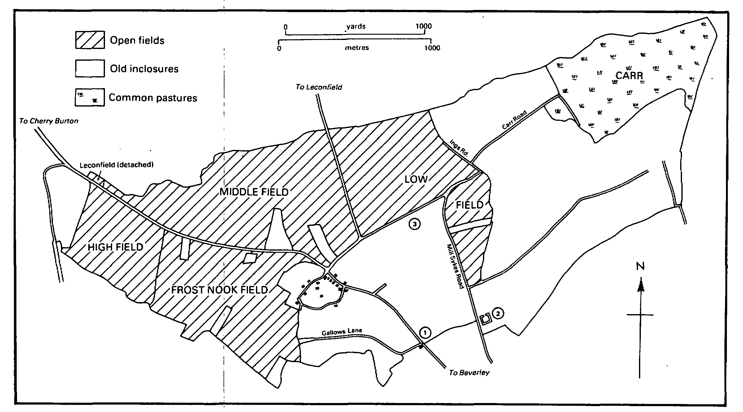
Molescroft, 1803
1. Probable site of Woodhall manor house 2. Site of Pighill manor house 3. Probable site of house called Estcroft
Molescroft is drained by streams and dikes flowing eastwards towards the river Hull. South Bullock dike forms much of the southern and eastern township boundary and another dike part of the northern boundary. Carr dike was recorded in the 13th century and Ing dike in 1504; (fn. 5) the latter may have been incorporated in the modern Ings drain, a continuation of a stream that runs down the small valley. The low grounds were dealt with by the new Beverley and Barmston Drainage Board, (fn. 6) and by the award of 1811 some 150 a. in Molescroft were rated to the drainage. (fn. 7) At least one drain in the township, in Pighill Lane, remained the responsibility of the Court of Sewers for the East Parts of the East Riding. (fn. 8)
The village of Molescroft stood at the junction of main roads from Malton and Driffield. (fn. 9) The former was perhaps that described as the way to the windmill in 1448. (fn. 10) There may have been a minster sanctuary cross beside each road. A cross said in the 12th century to stand beyond Molescroft, elsewhere described as standing beyond the valley at Molescroft (ultra vallem Mollescrofte), may have been the same as the Grith or Stone cross, recorded from c. 1300, which stood beside Stone Cross Gate. (fn. 11) In the 16th century Leland described the position of Molescroft cross as near the entrance to Leconfield park, evidently on the Driffield road, and he referred to another cross near Cherry Burton, (fn. 12) presumably on the Malton road. The road from Molescroft to Beverley, now Molescroft Road, was called High Street in 1439 and Ratton Row in the 17th century. (fn. 13) Beverley could also be reached from the Driffield road by way of a road known in different parts as Low Field Road, Mill Sykes Road, and Pighill Lane in the 19th century; the whole of it was renamed Woodhall Way c. 1940. (fn. 14) From Low Field Road access to the low grounds was provided by Ings Road and Carr Lane, and from Mill Sykes Road by Scrubwood Lane.
Other roads in the township included Beverley Gate, which in the 13th century crossed the low grounds from Arram, in Leconfield, to Mantholme, on the Beverley to Hull bridge road. (fn. 15) At inclosure in 1803 the road end, in Beverley, was awarded to certain Molescroft proprietors as the exit for a field road, later called Grange Lane. (fn. 16) Gallows Lane, which was first recorded in the 1540s and was perhaps the site of the archbishop's gallows, (fn. 17) led from the Molescroft-Beverley road near the borough boundary to the open fields; much of it was stopped up at inclosure in 1803, (fn. 18) though part of its sunken course was still visible in 1987.
The Hull-Bridlington railway line, opened in 1846, runs through the eastern part of the township. A branch line to Market Weighton, opened in 1865, also crossed the township; the line was closed in 1965 and the track has been lifted. (fn. 19)
Most of the village of Molescroft may formerly have stood along both sides of a street, known as Church Road in 1985, leading south-westwards from the main road junction. From the 14th to the 16th century it was called Towngate or Northgate, (fn. 20) and it evidently continued as a road to Bishop Burton in the 15th century. (fn. 21) A southern back lane, connecting the village street and the Beverley road, was stopped up at inclosure in 1803. (fn. 22) By the early 19th century there were also several houses beside the main road, and by the middle of the century the west side of the main road was closely built up for about 100 m. from the village street towards Beverley. (fn. 23)
At least two houses were built or rebuilt in the 18th century by Thomas Clarke (d. 1785). (fn. 24) The largest of them, later called Molescroft House (no. 63 Molescroft Road), had seven 'excellent' rooms in 1799; (fn. 25) it was remodelled c. 1928. (fn. 26) In the early 19th century other houses were built by Edward Ashley. They included Molescroft Cottage, later the White House (no. 52 Molescroft Road), which was built c. 1812 (fn. 27) and rebuilt in yellow brick c. 1900. Another of his houses, built c. 1816, (fn. 28) was divided in two in 1861, when one of them (no. 71 Molescroft Road) was rebuilt in a Gothic style by George Doyle. (fn. 29) New building in the later 19th century included a terrace of cottages in the old village street (now nos. 3-19 Church Road), (fn. 30) and several more large houses were built on Molescroft Road. The latter included Swiss Cottage (no. 49), built by 1852 probably by the Cankrien family, (fn. 31) and Elmsall Lodge (no. 30), built by Henry Dixon, a Hull silk merchant, in 1879. (fn. 32) Longcroft, later Longcroft Hall, standing well back from the road, close to the borough boundary, was erected by J. A. Hudson, son of a Hull brickmaker, c. 1863; it was designed by William Botterill of Hull. (fn. 33) The Beverley engineer Gordon Armstrong lived there in the 1930s and 1940s. (fn. 34) The house and part of its grounds were later occupied by a school and a technical institute. (fn. 35) The house has been much altered but the planting of the grounds was relatively undisturbed in 1987. On the Driffield road Molescroft, later Molescroft Hall, was built in the Queen Anne style c. 1900 by Richard Hodgson the younger, a member of the Beverley tanning family. (fn. 36) A town burial ground on Molescroft Road was laid out in the 1860s. (fn. 37)
The rapid growth of Molescroft as a suburb of Beverley began in the late 1920s with ribbon development along both of the roads leading from the town. By 1948 (fn. 38) the whole of the west side of Molescroft Road had been loosely built up with large houses, including those in Longcroft Park, a small estate laid out in the grounds of Longcroft Hall. (fn. 39) Many smaller houses were built in Woodhall Way. (fn. 40) Building had also taken place on the Driffield road (fn. 41) and several new houses were built in the old village street in the mid century. (fn. 42) From the 1950s further infilling on existing roads was accompanied by the building of large estates. By 1969 (fn. 43) much of the ground between Molescroft Road and Woodhall Way had been built over, and work had also begun on an estate east of Woodhall Way. Building in Westfield Avenue, started in the 1930s, was completed in the 1950s, (fn. 44) the Paddock was also built in the 1950s, (fn. 45) and Molescroft Park (fn. 46) and St. Leonard's Road (fn. 47) both date from c. 1965. About 45 council houses had been built in or near Woodhall Way by 1969. (fn. 48) Recent infilling near the old village has included small estates laid out in the grounds of Molescroft Hall and Molescroft House. (fn. 49) A secondary school for the Beverley area was opened in 1950. (fn. 50) From 1906 sewage from the Molescroft Road area was carried into the town sewerage system, but from 1952 the growing suburb was served by a sewerage works in Molescroft, at Ings Road; after 1974 sewage from the whole of Molescroft was again taken to the Beverley treatment works. (fn. 51)
Outlying buildings in the township in the Middle Ages included the manor houses of Pighill and Woodhall and a chief house called Estcroft. (fn. 52) There were no other farmhouses away from the village until the 19th century, but several were built soon after inclosure in 1803. Carr Close or Low Field Farm, later Molescroft Grange, was put up by 1805, (fn. 53) Constitution Hill Farm c. 1810, (fn. 54) and Carr House or Molescroft Carr Farm by 1811. (fn. 55)
A licensed house was recorded at Molescroft from 1754; (fn. 56) it was called the Marquis of Wellington in the early 19th century, later the Battle of Trafalgar, and from c. 1875 the Molescroft. (fn. 57) Part of the ground awarded at inclosure in 1803 for a pit was occupied from 1895 as allotment gardens. (fn. 58) A recreation ground was provided on Woodhall Way c. 1971, (fn. 59) and from 1975 rooms at the primary school were used by the parish council and known as Molescroft parish centre. (fn. 60)
There were 99 poll-tax payers at Molescroft in 1377 (fn. 61) and 41 households were listed in the hearth-tax return of 1672. (fn. 62) From 67 in 1801 the population rose to 98 in 1811 and then steadily to 203 in 1901 and 261 in 1931. Numbers later rose rapidly to 689 in 1951, 1,453 in 1961, 2,738 in 1971, and 3,154 in 1981. (fn. 63)
MANORS AND OTHER ESTATES.
In 1086 the whole of Molescroft, comprising 3 carucates, belonged to the archbishop of York but half of it was held by St. John's college as his undertenant. (fn. 64) The archbishop had a grant of free warren there in 1236 (fn. 65) but his demesne, later put at 2 carucates, was wholly subinfeudated by 1303. (fn. 66) The overlordship descended with Bishop Burton manor. (fn. 67)
The archbishop's fee included an estate at Woodhall held by knight service from the mid 13th century by a family of that name. The first known undertenant was Roger, son of Sir William of Woodhall, who sold part of the estate c. 1270. (fn. 68) Another Roger held 2 bovates of the archbishop in 1303. (fn. 69) He was succeeded in 1307 by William of Woodhall, at whose death by 1343 the manor of WOODHALL passed to William's daughter Joan and her husband Sir Simon of Heslerton. (fn. 70) The estate evidently passed, with land held of the provost of Beverley, to Sir Thomas Sheffield, possibly as the Heslertons' feoffee, and by 1378 had been acquired by Sir Ralph Hastings (d. c. 1400). (fn. 71) The manor, which was twice held in dower in the mid 15th century, descended in the Hastings family to George Hastings, Lord Hastings, who sold it to William Holgill, master of the Savoy hospital, London, in 1527. (fn. 72) Edmund Holgill and his son John sold the estate in several lots in the 1570s. (fn. 73) Ralph Hansby bought the manor in 1579 and other land in Molescroft the following year. (fn. 74) Hansby (d. 1619) settled his estate in moieties, one on his daughter Gillian and her husband Sir John Yorke and the other on his grandson Christopher Wandesford. (fn. 75) The shares were evidently reunited after 1626 and the manor sold to Roger Beckwith. (fn. 76) He was succeeded in 1635 by his son Thomas, who compounded for the estate in 1650, (fn. 77) and Thomas by his brother Matthew, (fn. 78) who sold it to Michael Warton in 1669. (fn. 79) Woodhall later descended, with other land of the Wartons in Molescroft, like the manor of Beverley Water Towns. (fn. 80) In 1775, at the partition of the Warton estate, 150 a. in the township fell to the share of Michael Newton, (fn. 81) who surrendered 37 a. to extinguish his tithes at inclosure in 1803. (fn. 82) At the latter date the Woodhall estate occupied much of the ground lying between Molescroft Road and Woodhall Way. In 1812 and 1813, after Newton's death, the estate was sold (fn. 83) in several lots, Henry Legard (d. 1819) buying 50 a. (fn. 84) Legard's devisee, Sir Thomas Digby Legard, Bt., (fn. 85) divided and sold the estate in 1841. (fn. 86)
The chief house of the manor was recorded from the 14th to the 16th century. (fn. 87) It has been supposed that the house occupied a moated site near the former Low Field Road. That was not, however, part of the Woodhall estate in 1803 and evidently belonged to another estate by the late 16th century. It was probably the site of a house called Estcroft. (fn. 88) Woodhall manor house apparently stood on the east side of the Molescroft-Beverley road, close to the town boundary: in 1595 closes on the west side of the road, next to Gallows Lane, were described as lying opposite le Woodhall, (fn. 89) and in 1626 it was said that the horse fair held in the street outside North bar began at the Woodhall. (fn. 90)
Part of the Woodhall estate, including 4 bovates, was sold by Roger of Woodhall to Richard Carter c. 1270 (fn. 91) and about the same date Richard acquired other land from his aunt Isabel of Bilton. (fn. 92) In 1312 a house and its appurtenances called le Pighel belonged to John son of Philip Carter, (fn. 93) who in 1347 settled the manor of PIGHILL on John Roos and his wife Ellen. (fn. 94) John Roos may have been succeeded c. 1369 by a namesake, (fn. 95) whose son Thomas held the estate by 1402. (fn. 96) The manor and 30 a., held of Bishop Burton manor, (fn. 97) descended in turn to Guy Roos and his son Thomas, who had it by 1466. (fn. 98) The manor evidently later belonged to Martin Roos (d. c. 1590), whose son Henry (fn. 99) sold it, with 5 bovates and closes, to Peter Langdale in 1606. (fn. 100) In 1613-14 Langdale enlarged the estate, (fn. 101) which at his death in 1617 comprised the manor house and c. 60 a. His widow Anne was dowered in the estate, which descended to their son Marmaduke. Pighill manor was then reputedly held of the king's honor of Richmond as 1/10 knight's fee, and rent and suit of court claimed for Bishop Burton manor were later disputed. (fn. 102) Marmaduke, later Sir Marmaduke, Langdale served as a royalist commander, was created Lord Langdale in 1658, (fn. 103) and died in 1661. He was succeeded by his son Marmaduke, who sold part of the estate, comprising Pighill manor and a few closes, in 1671-2 to Sir William Wise. (fn. 104)
The manor descended, like Cottingham manor, from Sir William Wise (d. 1677) to Elizabeth Tadman. (fn. 105) It was settled in 1693 on Elizabeth's daughter, also Elizabeth, (fn. 106) and it was probably the same Elizabeth Tadman who sold it in 1759 to John Johnston. (fn. 107) The 9-a. estate was sold in 1793 to John Lockwood and then passed to the Revd. Robert Rigby, from whom William Beverley bought the manor and 5 a. in 1799. (fn. 108) In 1833 Beverley settled it, with other land in Molescroft, on trustees, (fn. 109) who sold it to John Nornabell the following year. Nornabell (d. 1874) was succeeded by Matthias Nornabell (d. 1891), whose widow Susan conveyed the estate to H. M. Nornabell in 1904. It was sold in 1909 to Tom Marchant. (fn. 110) Part of the moated site was sold for housing alongside Pighill Lane in the early 1930s (fn. 111) and the rest was later sold several times (fn. 112) before also being used for housing.
A manor house was recorded from the 14th century. (fn. 113) It was variously called Pighill Hall or House and Pighall in the 17th century, when its moat was mentioned; it had 10 hearths in 1672. (fn. 114) The house had been demolished by 1759 (fn. 115) but the moat remained until the later 20th century. (fn. 116)
After the sale of Pighill manor the rest of the Langdale estate descended to Marmaduke Langdale, Lord Langdale (d. 1778), who devised it to his daughters Mary, wife of Charles Stourton, Lord Stourton, Elizabeth, who married Robert Butler, and Apollonia, who married Hugh Clifford, Lord Clifford. (fn. 117) Sometimes known as the manor of MOLESCROFT, it included 1 carucate in 1676 and comprised 179 a. in 1770. (fn. 118) At inclosure in 1803 the heirs of Lord Langdale were allotted 74 a. and received a further 14 a. by exchange and 215 a. for tithes. (fn. 119) Under an Act of 1806 the 401-a. estate was divided and sold in 1807 and 1810. (fn. 120)
Molescroft manor and 192 a., including the 98-a. Carr Close farm, were bought in 1807 by William Joseph Coltman. (fn. 121) He bought a further 193 a. with Molescroft Carr farm from Sykes's trustees in 1812 (fn. 122) and 18 a. of Newton's estate in 1813. (fn. 123) Coltman (d. by 1832) was succeeded by his son and namesake. (fn. 124) The son sold the estate in two lots in 1856, the manor and c. 395 a. going to William Bainton, (fn. 125) who gave them to his son A. W. Bainton in 1894. (fn. 126) Nearly 230 a. were sold in 1912, Richard Ford buying the manor and the 194-a. Molescroft Grange farm, which he gave in 1923 to Percy Ford. (fn. 127) The farm was sold in 1935 to Charles and Leonard Smith, in 1948 to British Oil & Cake Mills Ltd., and in 1952 to H. W. Hall. (fn. 128) Another part of A. W. Bainton's estate, the 176-a. Molescroft Carr farm, was bought in 1918 by Oswald Smith (d. 1935) and sold by his widow Emma (fn. 129) as two lots in 1956. H. W. Hall bought 79 a. then and the rest in 1961. (fn. 130) Hall's estate was further enlarged by 33 a. in 1962. (fn. 131) In 1971 Molescroft Grange farm was conveyed to Thomas Hamling & Co. Ltd. and Molescroft Carr farm had also been transferred by 1987, when the company owned both farms. (fn. 132)
Another part of the Langdale estate, comprising 174 a., was sold in 1810 to Mark Bell and in 1832 by Bell and his assignees in bankruptcy to John Almack. (fn. 133) As Constitution Hill farm, the estate descended from Almack (d. 1876) to H. H. Almack (d. 1917) and then to the latter's son Richard. (fn. 134) After Richard's death in 1962 the farm was vested in Harold Almack and sold the same year to C. F. Deans. It was bought in 1976 by D. W. and P. Marginson, who still owned it in 1987 when it was farmed by R. Marginson (Farmers) Ltd. (fn. 135)
The largest modern estate in Molescroft was probably that of the Taylor family. (fn. 136) William Taylor was recorded from c. 1615. At his death in 1632 or 1633 he held 7 or 8 bovates and closes of Bishop Burton manor by military service. (fn. 137) The estate, which included some Chapter manor copyhold, was later much enlarged. (fn. 138) It descended to William's son John Taylor, who compounded for it in 1646 (fn. 139) and died c. 1666, to John's son William (fn. 140) (d. 1716), and then to William's grandson John Taylor (d. 1731), who devised it for life to his wife Bridget, later the wife of Ralph Pennyman. In 1750 it comprised 9 houses, 1 carucate, 7½ bovates, and many closes. At Mrs. Pennyman's death in 1774 (fn. 141) the estate passed in moieties to John Taylor's surviving daughters Margaret, wife of the Revd. Henry Goodricke, and Catherine, wife of Thomas Dawson. Margaret (d. by 1775) left her moiety to her husband and he and Catherine Dawson sold 56 a. in 1775 and 7 a. in 1776. (fn. 142) The rest, comprising 322 a., was sold by Goodricke and Thomas Dawson, son of Catherine (d. 1787), to Sir Christopher Sykes, Bt., in 1793. Sykes then also bought 108 a. formerly belonging to Mark Kirkby (fn. 143) and in 1801 c. 35 a. and Chapter copyhold from Thomas Clarke. (fn. 144) Sir Christopher died in 1801 and at inclosure in 1803 his son Sir Mark M. Sykes, Bt., was allotted 319 a. and received 4 a. by exchange, of which 32 a. were copyhold. (fn. 145) Sir Mark and Sir Christopher's other trustees sold 490 a. in many lots between 1812 and 1821. (fn. 146)
Molescroft Carr farm and 193 a. were sold by Sykes's trustees to W. J. Coltman in 1812 and descended with Molescroft manor. (fn. 147) Another 273 a. were sold to William Stephenson in 18201. (fn. 148) He died in 1829 and most of his estate was bought from his trustee by J. C. Cankrien in 1837-8. (fn. 149) Cankrien (d. 1853) was succeeded by his son H. K. Cankrien, who sold the estate to Francis Watt and the trustees of Richard Watt (d. 1855) in 1859. (fn. 150) The estate, known as Manor farm, descended like Bishop Burton to the Hall Watts. (fn. 151) It had been reduced (fn. 152) to c. 220 a. by 1960, when A. D. Hall Watt sold it to C. F. Deans. (fn. 153) It was sold in 1967 to Thomas Hamling & Co. Ltd., the owner in 1987. (fn. 154)
William Taylor had a house with seven hearths in 1672 (fn. 155) and Manor Farm, in Church Road, may stand on the same site. The 18th-century house was later Gothicized and had extensive outbuildings in 1987, when it was again being remodelled.
Six bovates of the archbishop's fee were held in 1303 by Roger Scoter. (fn. 156) At his death c. 1312 he held a house and 80½ a. called Scrubs directly of the archbishop and another house and 1 carucate and 4 bovates of others. A moated site formerly existing beside Scrubwood Lane may have marked the site of one of the houses. (fn. 157) Roger's daughter Elizabeth died c. 1314 and the estate was evidently partitioned betweeen two of her heirs. (fn. 158) Much of it may have fallen to the share of Roger Ingleberd, who was named as lord of Molescroft in 1316. (fn. 159) It evidently passed soon afterwards to Philip Ingleberd, rector of Keyingham, whose heir, another Roger Ingle berd, fulfilled Philip's intention by endowing a chantry at Molescroft in 1325. (fn. 160) The estate may have descended to Robert Ingleberd before passing to the Leeds family. Robert Leeds c. 1400 and William Leeds of Molescroft in the 1430s and 1440s both nominated to the chantry, and the latter's son, another Robert, held land of the provost's fee in 1448. (fn. 161) A later owner Thomas Leeds was succeeded by his son Robert (d. c. 1676). (fn. 162) Robert compounded for the estate, which had evidently been enlarged with part of the Woodhall estate, in 1646 (fn. 163) and in 1655 settled it on his son Inglebert, the owner in 1698. It then comprised an eight-hearth house called 'lane rack hall', 6 bovates, and many closes, besides some Chapter manor copyhold. (fn. 164) It has not been certainly traced further.
The other part of the Scoter estate fell to the share of John Cockerill c. 1314 (fn. 165) and descended in the Cockerill family until the 16th century. (fn. 166) It was said to comprise a manor place or mansion place and 100 a. in Molescroft c. 1520, when the title of Richard Cockerill's son-in-law Richard Askew was unsuccessfully challenged. (fn. 167) The estate was sold by the Askew or Askwith family to Alexander Stockdale in 1545. (fn. 168) Stockdale (d. 1563) was succeeded by his son Robert in the 4bovate estate, then and later said mistakenly to be held of the manor of Beverley. It passed before 1623 from Robert Stockdale to a relative John Estoft, who then settled it on his son Thomas. He or another Thomas was succeeded c. 1660 by his son John, (fn. 169) after whose death by 1695 the estate was vested in trustees for its sale. (fn. 170)
Either the Leeds or the Estoft estate may have passed to the Ash family. Robert Ash (d. 1710) left 5 bovates and closes to his sons Metcalfe and Christopher, who sold their moieties in 1711 and 1714 to James and Richard Grayburn. (fn. 171) It was probably another James Grayburn who bought c. 70 a. more in 1736 and held land of the Chapter manor c. 1740. (fn. 172) Marmaduke Grayburn (d. 1775) left his estate in Molescroft to his son William. (fn. 173) At inclosure in 1803 William Grayburn was allotted 89 a. for his commonable lands and received 7 a. by exchange; (fn. 174) the next year he sold the 113-a. estate to Josiah Prickett. (fn. 175) It was bought by Mark Bell in 1817 and, as a 100-a. farm, by Robert Dixon in 1835. (fn. 176) Dixon (d. by 1849) was succeeded by his widow Rosamond (d. by 1860) and she by William Bainton, evidently as trustee. (fn. 177) The farm was conveyed in 1875-6 to T. C. Dixon (fn. 178) (d. 1899), who was succeeded in turn by his son T. C. B. Dixon (d. 1906) and Robert Dixon. (fn. 179) It was sold, as Elmtree House farm, in 1909 to the Hall Watts and in 1958 by A. D. Hall Watt to J. D. Cooke. In 1987 the farm, then called Elm Tree farm, was owned by Mr. Cooke and Mrs. B. A. Cooke. (fn. 180) The house, in Church Road, dates from the 18th century but was evidently remodelled in the 19th. (fn. 181)
The St. John's college estate in Molescroft had evidently been divided between the chapter and the provost by the 1290s. (fn. 182) The chapter part was apparently assigned to the prebendary of St. Martin and the vicars choral. The prebendary had rents amounting to £6 13s. 10d. from 6 bovates and other land in Molescroft c. 1308. (fn. 183) His estate was worth £7 6s. 3d. a year in 1535, when rents of 7s. 10d. also belonged to the vicars choral. (fn. 184) The provost's estate included 2 carucates and 5 bovates in 1448, when it was held by a dozen undertenants. The undertenants included the lord of Woodhall manor. (fn. 185) Roger Scoter (d. c. 1312) held 4 bovates of the provost which descended to his nephew James Jordan and his heirs before being sold to the Frost family, the undertenant in the late 14th and mid 15th century. (fn. 186) The Roos family's estate also included land of the provost's fee; Guy Roos held 5 bovates of him in 1448. (fn. 187) Another of the provost's undertenants was John Bedford, who in 1448 held 6 bovates and a chief house called Estcroft, which had evidently once been part of the Woodhall estate. (fn. 188) The house probably stood east of the village on the south side of the former Low Field Road, where closes were known c. 1800 as Low, Middle, and High East Crofts. (fn. 189) A moated site there was occupied from the 13th to the 15th century. (fn. 190)
After the suppression of the college the former estates of the chapter and the provost became part of the Crown manor of Beverley Chapter (fn. 191) or were granted away. Five bovates in Molescroft included in the Crown grant of concealed lands in 1585 to Beverley corporation (fn. 192) had presumably belonged to the college. They were evidently sold, for no more is heard of them. Part of St. Martin's prebend, comprising 3 bovates and closes, was sold in 1588 to Edmund Downing and Miles Dodding; it evidently belonged by 1590 to Michael Warton, and presumably descended with Woodhall manor. (fn. 193)
The Chapter manor, largely or entirely made up of land formerly belonging to the prebend of St. Martin, was said to include 6 copyhold bovates in Molescroft in 1655. (fn. 194) The remaining copyhold, amounting to c. 30 a., was mostly enfranchised in the 1830s. (fn. 195) Three of the copyhold bovates descended from Martin Roos (d. c. 1590) to his son Henry (fn. 196) and passed, with his Pighill estate, to the Langdales in 1606. (fn. 197) The other 3 copyhold bovates of the Chapter manor were said to be held in 1655 by Henry Weddall or Woodhall. (fn. 198) It was probably the same estate, also of 3 copyhold bovates, which descended to Margaret Ashmole in 1683 and belonged to the Ashmole family until 1751. It was sold three times in the mid century, finally in 1764 to Thomas Clarke (d. 1785), whose son Thomas sold it in 1801 to Sir Christopher Sykes, Bt. (fn. 199) In 1812 c. 32 a. awarded to Sir Mark M. Sykes, Bt., in 1803 were declared to be copyhold. (fn. 200) They passed with other Sykes land in 1820-1 to William Stephenson and in 1838 to J. C. Cankrien, who secured their enfranchisement. (fn. 201)
After the suppression of St. John's college, to which most of them had belonged, (fn. 202) the tithes of Molescroft were at first let as moieties by the Crown, (fn. 203) but both halves were granted in fee in 1608 to Richard Moore and Thomas Mountford. They were sold the same year to Edward Dodd and again in 1609 to John Stanhope, Lord Stanhope. Peter Langdale bought them in 1612. (fn. 204) The tithes were confiscated from his son Sir Marmaduke Langdale during the Civil War. A payment from them was made in 1646 to the assistant curate of the minster. (fn. 205) They were worth £100 a year in 1650 (fn. 206) and in 1651 were let to Beverley corporation. (fn. 207) They were recovered at the Restoration and were let by the Langdales, in the later 17th century for c. £80 a year. (fn. 208) Some were sold with Pighill manor in 1671 and were presumably later merged. (fn. 209) Most of the rest were commuted for an allotment of 164 a., 51 a. of old inclosures, and a piece of land in Beverley, all awarded to Lord Langdale's heirs at inclosure in 1803. (fn. 210) Tithes from 109 a. were, however, excluded from the award. (fn. 211) Those from 83 a. were bought in 1807 by W. J. Coltman, who sold the tithes of some 30 a. to other landowners, (fn. 212) and those from 26 a. were bought by Mark Bell in 1810. (fn. 213) All were eventually merged.
The corn tithes of land belonging to Killingwoldgraves hospital were held by the hospital until the Dissolution and then passed with the former hospital to Sir William Gee in 1605. (fn. 214) They were sold in 1653 by Thomas Gee to William Blount, (fn. 215) in 1695 by Blount's son John to John Greaves, in 1735 by Greaves's nephew Thomas Greaves to Robert Appleton the younger, and in 1736 to James Grayburn. (fn. 216) At inclosure in 1803, when they comprised the corn and hay tithes of c. 20 a., the owner was William Grayburn, who received 3 a. for them. (fn. 217)
Killingwoldgraves hospital, in neighbouring Bishop Burton parish, had an estate in Molescroft by 1312, and in 1448 it held a bovate of the provost's fee. (fn. 218) After the Dissolution land belonging to the former hospital descended with it to the Gees (fn. 219) and some later passed with the tithes to James Graburn. (fn. 220) By 1801 the estate apparently comprised c. 20 a., most of which belonged to Sir Christopher Sykes, Bt., and the rest to William Graburn. (fn. 221)
Several other estates in Molescroft belonged to religious foundations. Meaux abbey was given 1 carucate by Sir Ralph Savage between 1182 and 1197 (fn. 222) and had a grant of free warren there in 1292. (fn. 223) The estate was let in the later 16th century by the Crown. (fn. 224) Land formerly belonging to the abbey was granted in fee to Edward Bates and Henry Elwes in 1610 and sold in 1629 to Sir Baptist Hicks, Viscount Campden. (fn. 225) The Knights Hospitallers held a house and 2 a. in Molescroft in 1418, when the undertenant was Ralph Greystoke, Lord Greystoke. (fn. 226) The estate descended in the Greystoke, Dacre, and Howard families to Charles Howard, later earl of Carlisle, the owner in 1652. (fn. 227) St. Giles's hospital, Beverley, held land in Molescroft which was granted by the Crown to Thomas Manners, earl of Rutland, in 1536. (fn. 228) Chantries in the minster also had estates there. St. John of Beverley's chantry was endowed at its foundation in 1450 with a house in Molescroft, (fn. 229) and it had land called Woodcroft adjoining Gallows Lane, sold in 1609 to John Johnson. (fn. 230) Land formerly belonging to the chantry of Corpus Christi in the charnel was granted by the Crown in 1558 to Henry Becher. (fn. 231) Another close called Woodcroft, described as lying outside North bar in the fields of Beverley, was later said to be in Molescroft. It evidently also lay near Gallows Lane and belonged to the chantry of St. Nicholas in St. Mary's church, Beverley, before being granted in fee in 1607 to George Ward and Robert Morgan, who sold it to Thomas Smales the same year. (fn. 232) Three acres in Molescroft were evidently given for the upkeep of the fabric of St. Mary's and were included in the Crown grant of concealed lands in 1585. (fn. 233) The churchwardens were allotted 4 a. for them at inclosure in 1803. (fn. 234)
ECONOMIC HISTORY.
The open fields of Molescroft were mentioned from the 13th century, when they included several 'riddings', or clearings, one of them inclosed by ditches. (fn. 235) Two of the riddings were later demesne of Pighill manor, (fn. 236) one of them described in 1448 as lying in Pighill field. (fn. 237) Some of the demesne may thus have been consolidated at an early date and Pighill field had been inclosed by 1479. (fn. 238) The largest of the open fields was probably that named as East field in 1504 (fn. 239) and Low field from 1622, when it extended to the boundary with Storkhill; it was later reduced by the making of closes. (fn. 240) There were apparently two other fields in the 16th and 17th centuries, when they were known as Gallow and West Hale fields, (fn. 241) but the open-field land may later have been subject to a four-course rotation for it comprised Low, Middle, High, and Frost Nook fields by the late 18th century. (fn. 242) Middle field was then evidently also called Chapel field. (fn. 243) The right of Beverley burgesses to put their animals in the fields after harvest was unsuccessfully challenged by the inhabitants of Molescroft in 1567-8. (fn. 244) Common meadow land, lying between Low field and the carrs, was called Molescroft ings in the 16th century and alternatively the Wands in 1793. (fn. 245) Rough grazing was provided by the carrs, recorded as the common marsh in the 13th century. (fn. 246) On the eve of inclosure there were 132 a. of unstinted common in Molescroft, all lying in the carrs except 3 a. beside the Malton road called Anacy Green. (fn. 247)
The Pighill demesnes formed part of a large area of old inclosure in Molescroft. Inclosures made from the open fields presumably included the 1-bovate Maudlin Riding close, belonging to Killingwoldgraves hospital, which was mentioned from 1327. (fn. 248) Other Riding closes were recorded in the 18th century, together with nearly 40 a. in Low field closes. (fn. 249) A 30-a. close called Whitefield, mentioned from 1610, may also have been taken from Low field. (fn. 250) Much of the old inclosure may formerly have been woodland. The woodland probably included the 80-a. Scrubs, which was recorded in the 14th century (fn. 251) and evidently adjoined the carrs, giving its name to Scrubwood or Scrogwood Lane. (fn. 252) The trees had presumably been cleared by the 17th century, when a pasture close called Scrubbfield was mentioned. (fn. 253) Other woodland, on the northern boundary of the township, was known from the 17th century as Canon Scrubs or Scrogs or Lillywhite wood, (fn. 254) the latter after the family of that name. (fn. 255) It comprised a 7-a. close of 'woody ground' in 1776 but was apparently cleared c. 1800; (fn. 256) c. 40 a. of old inclosures nearby called Whitewood closes may formerly have been part of it. (fn. 257) The demesnes of Pighill and Woodhall manors also included woodland. In 1369 the lord of Pighill let the right to 100 faggots a year from Pighill field. (fn. 258) At Woodhall there was a 10-a. wood in the 15th century, (fn. 259) and in 1774 the Warton estate there and elsewhere in Molescroft bore over 600 trees, mostly oaks. (fn. 260) By 1803 there were at least 432 a. of old inclosures in the township. (fn. 261)
Tenants' rents amounting to nearly £7 com prised the entire value of the prebendary of St. Martin's estate c. 1308; most of the rent was for 6 bovates and a toft, described as demesne, some marshland, and the pasturage of Riding. (fn. 262) In the 14th and 15th centuries tenants of the provostry owed money rents and 12 fowls, and also ploughing and harvesting works at Cherry Burton and Riding fields in Beverley, though the works could be commuted. (fn. 263) In 1543 rents of nearly 15s. were paid by a dozen free tenants on the former archiepiscopal estate, which was then regarded as part of Bishop Burton manor. (fn. 264)
The remaining commonable lands in Molescroft were inclosed in 1803, under an Act of 1801. (fn. 265) There were 685 a. to be dealt with, and allotments made totalled 667 a., comprising 181 a. from Middle field, 145 a. from Low field, 140 a. from Frost Nook field, 74 a. from High field, 123 a. from the carrs, and 4 a. from lanes. (fn. 266) The ings were not mentioned but were evidently treated as part of Low field. (fn. 267) Sir Mark M. Sykes, Bt., was allotted 319 a., Lord Langdale's heirs 238 a., and William Grayburn 92 a., the last two allotments including an acreage for tithes. There were five other allotments, all of under 10 a. A 1-a. allotment for ground belonging to Leconfield park was assigned to that parish.
There were usually half a dozen farmers in Molescroft in the 19th and earlier 20th century, of whom 3 in 1851 and 4-5 in the 1920s and 1930s had 150 a. or more. From the mid 19th century one or two men also produced milk for Beverley and in the 1930s there was much grassland around the village and on the lower ground. Vegetables were also grown for the local market: in 1851 a nurseryman was recorded and later up to three market gardeners. (fn. 268)
A mill was recorded at Molescroft in the 14th century, (fn. 269) there were said to have been two windmills there in the 16th, and one was mentioned in 1721. (fn. 270) A mill presumably stood in the north-western corner of the township, where Mill hill was mentioned from the 16th century. (fn. 271) It was perhaps that which was described as broken in 1625. (fn. 272) There may also have been a mill near Pighill manor house, where there were grounds called Mill holmes closes in the 17th century (fn. 273) and a road called Mill Sykes Road in the 19th century. (fn. 274)
LOCAL GOVERNMENT.
The franchises of the provost's liberty in Molescroft included the assize of bread and ale, and waifs and strays. His tenants there owed suit to his courts at the Bedern. (fn. 275) The chapter's franchises included the escheats of felons. (fn. 276) A constable to serve Molescroft was appointed by Beverley corporation in the late 16th century. (fn. 277) Officers were later appointed at Beverley Chapter manorial court. They included two bylawmen and a bailiff in the 17th century, and a constable then and later. (fn. 278)
A cottage at Molescroft was used as a poorhouse c. 1800. (fn. 279) The township joined Beverley poor-law union in 1836 (fn. 280) and remained in Beverley rural district (fn. 281) until 1974, when it became part of the Beverley district of Humberside. A parish council was established for Molescroft in 1937. (fn. 282)
CHURCH.
The township, part of St. John's parish, Beverley, may have been served in the Middle Ages by the prebendaries of St. James and St. Stephen in the collegiate church, who enjoyed the tithes there. (fn. 283) Baptisms, marriages, and burials usually took place in the minster. (fn. 284) In 1323 Philip Ingleberd, rector of Keyingham, was licensed to build a chapel at Molescroft, dedicated to St. Mary, and a chantry there was ordained the next year, partly to benefit the villagers whose mother church was distant. In 1325 Philip died and his heir Roger Ingleberd endowed the chantry with land and rent in Molescroft, Beverley, and Paull. (fn. 285) The chapel was evidently used sometimes for marriages, as in 1469. (fn. 286) It contained a statue of the Virgin for which gold was left in 1498. (fn. 287) In 1535 the chantry had rents totalling £5 2s. 8d. and in 1548 it was worth £4 11s. 7d. net. (fn. 288) After its suppression the 'chapel house' was granted in fee to John Farnham in 1576 and another part of its former estate, including a 'mansion' house and two cottages in Molescroft, to Francis Morrice and Edmund Sawyer in 1616. (fn. 289) One or more inclosures called Chapel close may also have been former chantry property. (fn. 290) The chapel evidently stood in the village street. (fn. 291) There was also a hermitage at Molescroft in the mid 14th century. (fn. 292)
Services were held in a house at Molescroft in the mid 19th century (fn. 293) and in a hired mission room by 1883. (fn. 294) A small chapel of ease there was opened in 1896 and licensed for services, including communion, the next year. (fn. 295) It was served by assistant curates from the minster. One service was held each Sunday c. 1900 and communion was celebrated monthly in 1931. (fn. 296) The so-called church of St. Leonard is built of yellow brick in a plain Early English style to designs by Messrs. Hawe & Foley. (fn. 297) It consisted of undivided nave and sanctuary with northwest vestry, west bellcot, and wooden south porch until 1979, when a chancel was added. (fn. 298) Molescroft used the St. John's parish burial ground in Queensgate, Beverley, consecrated in 1861. (fn. 299)
NONCONFORMITY.
Wesleyan Methodists held services at Molescroft in the 1820s, (fn. 300) and a preaching station was established there by Particular Baptists and supplied from their chapel in Beverley in the later 19th century. (fn. 301)
EDUCATION.
An infants' school at Molescroft, begun in 1831, was attended in 1833 by 6 boys and 8 girls, all taught at their parents' expense. (fn. 302) There was no school in 1871, when the children went to Beverley. (fn. 303) A 200-place primary school, together with rooms to be used by the parish council, was opened in 1975 in St. Leonard's Road to provide for the rapidly growing population. Temporary accommodation was also used from 1978. There were 204 pupils on the roll in 1986. (fn. 304) Income from Anne Routh's charity was shared with other elementary schools in St. John's parish. (fn. 305)