A History of the County of York East Riding: Volume 6, the Borough and Liberties of Beverley. Originally published by Victoria County History, London, 1989.
This free content was digitised by double rekeying. All rights reserved.
A P Baggs, L M Brown, G C F Forster, I Hall, R E Horrox, G H R Kent, D Neave, 'Outlying townships: Weel', in A History of the County of York East Riding: Volume 6, the Borough and Liberties of Beverley, ed. K J Allison (London, 1989), British History Online https://www.british-history.ac.uk/vch/yorks/east/vol6/pp308-313 [accessed 30 April 2025].
A P Baggs, L M Brown, G C F Forster, I Hall, R E Horrox, G H R Kent, D Neave, 'Outlying townships: Weel', in A History of the County of York East Riding: Volume 6, the Borough and Liberties of Beverley. Edited by K J Allison (London, 1989), British History Online, accessed April 30, 2025, https://www.british-history.ac.uk/vch/yorks/east/vol6/pp308-313.
A P Baggs, L M Brown, G C F Forster, I Hall, R E Horrox, G H R Kent, D Neave. "Outlying townships: Weel". A History of the County of York East Riding: Volume 6, the Borough and Liberties of Beverley. Ed. K J Allison (London, 1989), British History Online. Web. 30 April 2025. https://www.british-history.ac.uk/vch/yorks/east/vol6/pp308-313.
In this section
WEEL
The village of Weel stands about 2½ km. east of Beverley on the opposite bank of the river Hull, and direct access from the town was until recent times by ferry. The suitability of the river there as a crossing point may be suggested in the name, which means 'a deep place in a river' and is Anglian. (fn. 1) Weel was among the 'water towns' of Beverley. (fn. 2) The township, which contained 1,131 a. in 1852, formed a civil parish. (fn. 3) In 1935 it was combined with Eske, Storkhill and Sandholme, and Tickton and Hull Bridge civil parishes as Tickton civil parish. (fn. 4)
The whole township lies at less than 7 m. above sea level; much is covered with alluvium, but in the middle of the township deposits of boulder clay form slightly higher ground. There was evidently also some sand at the village site which has been worked out. (fn. 5) The open fields and the village lay on the higher land, while the alluvial grounds were occupied by common meadows, pastures, and carrs. (fn. 6) Most of the commonable lands, including the open fields, were inclosed by the mid 17th century but the carrs not until 1786.
The low-lying grounds in Weel were often flooded (fn. 7) and, like Eske, the township shared the drainage problems common to the whole of the eastern side of the Hull valley. (fn. 8) Drains mentioned in the Middle Ages included Park dike, made in the mid 12th century to divide a proposed park at Meaux, in Wawne, from Weel carr. (fn. 9) Another drain ran along the northern boundary of the township to discharge into the river. (fn. 10) Skaith or Double dike was mentioned from the 15th century, when it was said to form the eastern and southern boundaries. (fn. 11) The name was later applied to a drain, now called Weel Stone Carr drain, flowing between Weel carr and Weel Stone carr. (fn. 12) The sluice at its former junction with the river was presumably that which was repaired in 1563-4 with a contribution from the town of Beverley. (fn. 13) A wind pump stood beside Causeway Dale drain in the mid 17th century. (fn. 14) Improvements to the drainage of neighbouring Wawne c. 1675 included the building of Black Bank along the southern boundary of Weel. (fn. 15) By the drainage award of 1775 as many as 753 a. in Weel were rated to the work of the new Holderness Drainage Board. The main drain was diverted from the boundary to a new course across the north-east corner of the township between 1781 and 1838. (fn. 16) By the drainage award of 1838 there were 723 a. of rateable low grounds in Weel. (fn. 17) Drainage works have included the maintenance of flood banks alongside the river.
Access to Beverley was for long provided by a ferry from the village to a road running along the south side of Beverley beck. (fn. 18) The ferry existed by the 15th century and in the 16th the town of Beverley contributed several times towards the renewal or repair of the boat. (fn. 19) The ferry boat of the Water Towns manor which was improperly used in the 1680s was perhaps that at Weel. (fn. 20) The ferry was in use until c. 1920. (fn. 21)
A ferry at Grovehill, about 800 metres northwest of the village, existed by 1852. (fn. 22) It evidently belonged to Beverley corporation by the 1890s. (fn. 23) In 1902-3 the owner of Weel shipyard leased the ferry from the corporation and replaced it with a pontoon swing bridge, on which he took tolls. (fn. 24) The bridge was operated from 1938 by the corporation, (fn. 25) which moved it a few yards further south during the Second World War. In 1949 the poorly maintained bridge sank for the last time. A boat was used again (fn. 26) until 1953, when the corporation built a toll-free bridge, with lifting apparatus on the Grovehill side. (fn. 27)
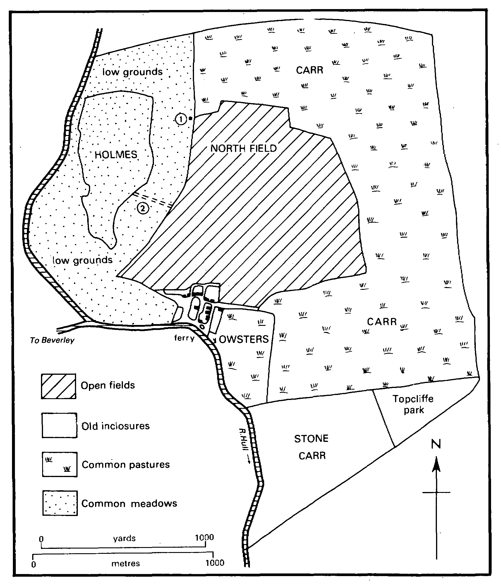
Weel in the early 17th century
1. Wind pump 2. Causeway
The only public road in Weel is that leading from the village alongside the river to the bridge at Grovehill and then on to Hull Bridge. It was mentioned from 1685. (fn. 28) Its course was altered for a short distance opposite Grovehill c. 1900. (fn. 29) A road to the carrs, called town pasture lane in the 17th century, was probably incorporated in Carr Lane at inclosure in 1786. (fn. 30)
The village of Weel lies where the higher ground most closely approaches the river. Most of the houses stand along each side of Carr Lane, but a few are in three side lanes leading to the river bank and in another beside the river. Several small greens lying alongside the lanes were registered as common land in 1970. (fn. 31) The village remained very small until the mid 20th century, when some 25 more houses were built, including two council houses. A licensed house called the Ferry Boat or Ferry House was operated in conjunction with the ferry from the 1870s until it was closed c. 1970. (fn. 32) There was an institute at Weel in the 1930s. (fn. 33)
Outlying buildings include one or two farmhouses. Corporation and Hoggard House Farms may stand on sites used from the earlier 18th century. (fn. 34) Farmhouses added after the inclosure of 1786 included Butterbump Hall, demolished in the mid 19th century, Carr House Farm, which survives uninhabited, and New Holland Farm, (fn. 35) which was razed in 1984. (fn. 36) Spring Dale Farm was built in the later 19th century. (fn. 37) One or two cottages standing near the Grovehill ferry by 1852 (fn. 38) were joined by half a dozen others and a shipbuilding yard c. 1900. (fn. 39) The yard has since been removed but a row of cottages remains. Much of Hoggard House farm was used as a local authority rubbish tip and infill site from 1964. (fn. 40)
Seventeen households at Weel were listed in the hearth-tax return of 1672. (fn. 41) From 96 in 1801 the population rose to 136 in 1831; it again reached 136 in 1901, but was only 114 in 1931. (fn. 42)
MANOR AND OTHER ESTATES.
In 1086 the whole of Weel, comprising 2 carucates, was held by St. John's college as a berewick of the archbishop of York's manor of Beverley. (fn. 43) By the late 13th century the estate had passed to the archbishop and part had been subinfeudated. (fn. 44) The rest belonged to the archbishop until 1542; it later formed part of the manor of Beverley Water Towns, passing to C. A. Pelham in 1775. (fn. 45)
Much of the land in the township was copyhold: 694 a. in 1805 (fn. 46) and still c. 360 a. in 1899. (fn. 47) In the 18th century the demesne freehold comprised a house, a cattle gate, and 100 a. (fn. 48) Pelham received 5 a. for his pasture right at the inclosure of the carrs in 1786. (fn. 49) In 1805 the Pelhams sold the holding to Richard Fox, a Beverley alderman, (fn. 50) who already had 101 a. copyhold, including 41 a. awarded at inclosure. (fn. 51) Fox (d. 1823) left the estate to his natural daughter Harriet Fox, who in 1834 conveyed the freehold to her mother Elizabeth Taylor. (fn. 52) On Harriet's death that year the copyhold was forfeited to the lord of the manor on technical grounds but in 1835 it was enfranchised and sold to Elizabeth Taylor, (fn. 53) who apparently married John Westowby c. 1840. (fn. 54) After her death in 1867 Mrs. Westowby's devisees sold most of the estate in several lots. (fn. 55) The largest lot, of 67 a., was sold to William Duggleby in 1870 (fn. 56) and was bought in 1877 by F. B. Catterson (d. 1916), who left it to his widow Betsy; she sold it to Hull Co-operative Society Ltd. in 1917. (fn. 57) It was sold in 1930 to John Sharp and in 1944, after a foreclosure by the Agricultural Mortgage Corporation Ltd., to Leonard Moore (d. 1971). Ferry farm, as it was then called, was in 1972 vested in Reginald Moore. The land was sold in 1981 to a Mr. Shuttleworth. (fn. 58)
The part of Weel granted away by the archbishop comprised 3 bovates. The undertenant recorded from 1298 to 1315 was John of Staveley (fn. 59) and in 1346 Richard of Ask (perhaps for Eske). (fn. 60) The manor of WEEL was settled on Richard and his wife Joan, with remainder to Joan's heirs, in 1348-9, when it was held in dower by Margaret wife of William Bard. (fn. 61) It was perhaps the same Joan who, as widow of Robert of Holme, held land of the archbishop's fee in 1369. (fn. 62) An estate described as ¼ of the manors of Weel and Eske was conveyed by Sir John of Leek and his wife to Walter of Topcliffe and his wife in 1391. (fn. 63) The manors later belonged successively to John Topcliffe (d. by 1538) and his son Robert. (fn. 64) In 1573, when it included ground called Topcliffe park, it was sold by Richard Topcliffe to Richard Tailforde. It was sold in 1575 to Richard Frankland and conveyed in 1578 to William Frankland and his brotherin-law Robert Hebburne. In 1580 Hebburne conveyed his moiety to Frankland. The latter sold the estate in 1581 to Marmaduke Langdale (fn. 65) (d. 1611), who was succeeded by his greatnephew William Langdale. (fn. 66) Still including 3 bovates, it was sold in 1620 to Ambrose Fisher. In 1637 the estate was entailed on Fisher's son, also Ambrose. (fn. 67) The same or another Ambrose Fisher's heirs were his daughters Anne, Margaret, and Mary, who, with their husbands Robert Low, Robert Freeman, and William Green, in 1672 sold the estate to Beverley corporation. (fn. 68)
Part of the corporation estate was used to endow Ferrer's charity. (fn. 69) In 1773 the rest of the estate comprised c. 120 a. and 17 cattle gates in the carrs. (fn. 70) The corporation received 97 a. at the inclosure of the carrs in 1786, including an unspecified amount for the charity. (fn. 71) In 1787 the estate was reduced by an exchange by 22 a. (fn. 72) It was later occupied as Corporation farm, named from the early 19th century, (fn. 73) when it comprised 188 a. (fn. 74) It was enlarged with nearly 50 a. in 1847 and 13 a. in 1921. (fn. 75) The farm, then comprising 180 a., and a further 67 a. were sold in 1958 to Thomas Kell, who still owned them in 1987. (fn. 76)
A house was recorded on the estate from 1298. (fn. 77) It was called Weel Hall or Hallgarth in the 16th and 17th centuries, when it presumably stood in the village. (fn. 78) Its site, then called Ferry Croft, was sold to a Mr. Hall c. 1800, and was later occupied by Hall Farm, known as the Grange in 1984. (fn. 79) Corporation Farm, standing on former open-field land inclosed in the mid 17th century, existed by c. 1800. (fn. 80) The farmhouse was burnt down in 1731 but was evidently replaced before 1773 and was again rebuilt c. 1810 and in 1862. (fn. 81)
The part of the estate used in 1672 to endow Margaret Ferrer's charity comprised c. 16 a. in closes, appurtenant low grounds, and three pasture gates. After the charity share of the low grounds and inclosure allotment had been determined, the estate amounted to 39 a. In 1890 the land was used to endow the grammar school; (fn. 82) 26 a. were sold to Ernest Naylor and 13 a. to the corporation in 1920 — 1. (fn. 83)
The largest estate in Weel in the late 18th century belonged to John Hoggard, a Beverley alderman, (fn. 84) who received 141 a. at the inclosure of the carrs in 1786. (fn. 85) He sold 84 a. but the rest, amounting to 136 a., (fn. 86) passed on his death in 1790 (fn. 87) to his coheirs Ann Adamthwaite and Maria Elliott. (fn. 88) It was bought by S. B. Denton by 1828 and was known as Hoggard House farm by 1861. (fn. 89) In the late 19th century it passed to William Bainton (fn. 90) (d. 1901). His son and successor A. W. Bainton sold the farm with 92 a. in 1918 to Harold Naylor, (fn. 91) apparently as trustee for his father Robert Naylor, who added 10 a. in 1919 and was succeeded in 1928 by Harold. (fn. 92) The 102-a. farm was sold in 1947 to T. E. Dixon and in 1962 to Beverley corporation. (fn. 93) It passed in 1974 to Beverley district council, which still owned it, in 1987. (fn. 94) Hoggard House Farm stands on former common land inclosed in the mid 17th century and was mentioned, as Mimpy Dales Farm, in I777. (fn. 95) The house was rebuilt in the 19th century.
Soon after inclosure in 1786 John Hoggard sold 84 a. to Christopher Keld, who bought other land in Weel and acquired 22 a., including the site of the later New Holland farmhouse, by an exchange with Beverley corporation in 1787. (fn. 96) Keld (d. 1806) left his Weel estate to his daughter Elizabeth Foster and it later descended with an estate in Tickton as part of New Holland farm. It thus belonged to the Baintons in the late 19th and early 20th century. It comprised c. 115 a. in Weel and included the farmhouse. (fn. 97)
Other land in Weel was acquired by William Bainton, whose son A. W. Bainton had 471 a. there in 1917, when the estate was offered for sale. (fn. 98) Part, comprising 80 a., was bought in 1917-18 by Ernest Naylor, (fn. 99) who also bought 26 a. from Beverley Grammar School in 1920. (fn. 100) In 1947 he sold the 105-a. Chapel farm to G. H. Foster. (fn. 101) It was sold in 1948 to T. R. Lorenz (d. 1958) and in 1959 to T. W. Ellerington (d. by 1984) and Peter and Keith Ellerington, owners in 1984 (fn. 102) A further part of the Bainton estate, the 89-a. Eastfield farm, was bought in 1918 by G. W. Dunn (d. 1937), whose executors (fn. 103) sold it that year to Ernest Naylor. (fn. 104) In 1965 it was sold to D. J. B'. Riby, (fn. 105) who in 1945 had bought the 96-a. Carr farm, which he later enlarged. (fn. 106) Riby sold his 200-a. estate in 1970 to Boston Fishing Group Holdings Ltd., which was liquidated in 1972. (fn. 107) In 1979 the trustees of the liquidated company sold the estate to CIN Industrial Investments Ltd., which at the same time bought a futher 91 a. and remained the owner in 1984. (fn. 108)
After the suppression of St. John's college, to which they had belonged, (fn. 109) the tithes of Weel were let by the Crown to Michael Warton and in 1591 were granted in fee to Edmund Downing and Roger Rante. (fn. 110) The grant was evidently ineffective for in 1613 the tithes were granted to Francis Morrice and Francis Phillips and sold by them in 1615 to Sir William Cope, Bt., from whom Michael Warton bought them in 1627. (fn. 111) In 1650 the tithes belonged to Michael's father Sir Michael Warton (fn. 112) and were worth £18 a year. (fn. 113) They were paid by composition in the late 17th century. (fn. 114) At the partition of the Warton estates in 1775 the tithes of the demesne estate passed to C. A. Pelham; they were later sold with the land and were eventually merged. (fn. 115) The rest of the tithes fell to the share of Michael Newton, (fn. 116) who was awarded 61 a. for those of the carrs at inclosure in 1786. (fn. 117) The payment of tithes on Corporation farm was disputed c. 1800. (fn. 118) The uncommuted tithes on 545 a. were sold, after Newton's death, to John Lockwood in 1813. (fn. 119) Lockwood (d. 1827) (fn. 120) devised them to the Revd. W. R. Gilby and H. J. Shepherd, who sold them to William Simpson and Thomas Whitaker in 1842. (fn. 121) Several landowners, including Beverley corporation, (fn. 122) bought the tithes of their estates from Lockwood and his successors, (fn. 123) and by 1849 most of the tithes had been merged. (fn. 124) Those remaining, on 76 a., were then commuted for rent charges of nearly £17, payable to various landowners, who promptly merged the tithes, and to Beverley corporation. (fn. 125)
The seven parsons of St. John's college held ½ bovate in Weel in 1542-3, (fn. 126) and it was presumably the same land that was granted to Beverley corporation in 1585. (fn. 127) The trustees of Susanna Archer's charity bought 11 a. in Weel in 1847. The land was later used to endow the Foundation and grammar schools, before being sold in 1920. (fn. 128)
ECONOMIC HISTORY.
Rents from tenants at Weel contributed modestly to the value of Beverley manor. In 1340 bond tenants' rents produced just over £1 and their works 12s. and the rents of free tenants nearly 4s. (fn. 129) In 1542-3 eighteen customary tenants owed rents of just over £2 for 15½ bovates and other property and almost 5s. for 27 hens. Court profits were then some 2s. (fn. 130) In 1622 customary tenants held 13 bovates, two having 3-4 bovates each, three 12 bovates, and five less than a bovate; three customary tenants had no open-field land. The customary tenants then owed 25 'lake hens'. There was also a 3-bovate freehold. (fn. 131)
In the mid 13th century the townspeople of Beverley gave up their claim to common in the archbishop's pasture called Stone carr. (fn. 132) In 1340 Stone carr comprised 60 a. of meadow valued at £6 a year, (fn. 133) and in the mid 16th century the grazing of it was let for nearly £2 10s. a year. (fn. 134) The former demesne in Stone carr amounted to 100 a. in the early 19th century. (fn. 135)
The open fields of Weel lay on the higher ground north-east of the village, where ridgeand-furrow survived in 1987. (fn. 136) The tillage may have been enlarged in the Middle Ages by the making of clearings or 'ridings' for it later included lands called Rittings and Ryding butts. In the 17th century the fields, one of them then called North field, comprised c. 235 a. Northwest of the village was another island of higher ground known in the 17th century as the Holmes. It comprised c. 60 a., was probably occupied by common meadows, and included lands called North and West carr. Around the Holmes was lower lying meadow, some of which adjoined the river. Some of the riverside land was described as in Weel ings in 1649. (fn. 137) A causeway across the low grounds gave access to the Holmes from the open fields. The 35-a. Owsters or Oxters, southeast of the village, may have been a stinted ox pasture. (fn. 138) Common pasture was provided by the carrs, which were stinted by the mid 16th century. (fn. 139) In 1650 and later the stint of 5 beast gates a bovate (fn. 140) was sometimes exceeded (fn. 141) and geese were also kept there against the custom. (fn. 142) The number of gates was ordered to be reduced in 1682 because the carrs could not sustain the usual number on account of flooding. (fn. 143)
The open fields, the Holmes, and Owsters were inclosed by agreement between the lord of Beverley Water Towns manor, the copyholders, and the sole freeholder between 1620 and 1649. (fn. 144) Allotments were made totalling c. 325 a.: Ambrose Fisher received 61 a. for his freehold and 25 a. for his copyhold, and William Anlaby 74 a.; there were six allotments of 20-29 a. each, one of 13 a., and two of 6 a. (fn. 145) The owners of closes made from the Holmes evidently enjoyed shares of the adjoining low grounds, including, as in Tickton, the river flood bank, and those grounds were later apportioned between them. (fn. 146) The carrs were inclosed by an award of 1786, under an Act of the previous year. (fn. 147) They then contained 456 a. and provided 100 cattle gates. Allotments totalled 447 a.: John Hoggard received 141 a., Beverley corporation 97 a., and Michael Newton 61 a. There was also one allotment of 41 a., two of 20-39 a., three of 10-19 a., and two of under 10 a.
There were usually a dozen farmers at Weel in the 19th and earlier 20th century, of whom 4 in 1851 and up to half a dozen in the 1920s and 1930s had 150 a. or more. (fn. 148) The township was largely given over to crops in the 1930s, but meadow and pasture predominated in the former carrs. (fn. 149) The production of milk and vegetables for local markets has occupied a few men since the 19th century: one or two market gardeners were recorded from the 1850s, there were one or two cowkeepers c. 1900, and Ferry and Hoggard House farms were later used for dairying. (fn. 150) A cattle dealer was occasionally also mentioned and there was a pig farm in 1987.
There were no longer any windmills at Weel in 1625, when tenants owed suit to water mills in Beverley Parks. (fn. 151) Mill close, mentioned in the 19th century, lay south-west of Corporation Farm and may mark the site of an earlier mill. (fn. 152)
Apart from the fishing and fowling of Topcliffe park, which belonged to the owner of that estate, (fn. 153) the fishing and fowling of the river and carrs belonged to Beverley, and later to the Water Towns, manor. (fn. 154) The fowling of the demesne was let in the 17th century, when rent was paid for taking lapwings in Stone carr. (fn. 155) The fishing and fowling of tenants' land were let with the holdings (fn. 156) and were regulated in the manor court. In 1689, for instance, a man was presented for exceeding the customary number of nets in the carrs. (fn. 157) 'Dumbles' or reeds in the carrs were also let to the tenants, (fn. 158) and land there was still called Dumble Pits in the 19th century. (fn. 159)
A shipbuilding yard was established by Joseph Scarr on a site opposite Grovehill bought in 1892 and extended to c. 12 a. in 1896. (fn. 160) Joseph Scarr & Sons Ltd. was liquidated in 1931 but refounded the same year as Scarrs' Shipbuilding Co., which remained in business until 1938. (fn. 161) All traces of the yard were later removed.
LOCAL GOVERNMENT.
A constable to serve Weel was appointed by Beverley corporation in the late 16th century. (fn. 162) Officers were later appointed at the Beverley Water Towns manorial court. Those regularly chosen in the 17th and 18th centuries were a constable and a pennygrave, and in the 17th century also a surveyor of highways and one or two bylawmen. (fn. 163)
Weel joined Beverley poor-law union in 1836 (fn. 164) and remained in Beverley rural district (fn. 165) until 1974, when it became part of the Beverley district of Humberside.
CHURCH.
The township, part of St. John's parish, Beverley, may have been served in the Middle Ages by the prebendary of St. Peter in the collegiate church, who enjoyed the tithes there and in 1470 referred to his parishioners at Weel. (fn. 166) Baptisms, marriages, and burials usually took place in the minster. (fn. 167) From the 19th century some burials took place at Tickton. (fn. 168) Services were held in a farmhouse at Weel in 1851, (fn. 169) and from 1883 others were held in a hired mission room and in the school, at first occasionally but weekly c. 1890. (fn. 170)
NONCONFORMITY.
Wesleyan Methodists held services at Weel in the earlier 19th century. (fn. 171) A chapel there, built by Primitive Methodists in 1860 on land given by the Arnott family, (fn. 172) was closed in 1963. (fn. 173) It was used as a storehouse in 1987.
EDUCATION.
A school at Weel, begun in 1819, was attended in 1833 by seven girls and five boys, all taught at their parents' expense. (fn. 174) It was not mentioned again. In 1871 the children went to Beverley. (fn. 175) A mixed Church school, begun in 1889 in a converted barn on the north side of Carr Lane, was evidently closed after a few years. (fn. 176) Children from Weel later attended Tickton school but in 1914 they were transferred to Beverley. (fn. 177)