Survey of London: Volumes 43 and 44, Poplar, Blackwall and Isle of Dogs. Originally published by London County Council, London, 1994.
This free content was digitised by double rekeying. All rights reserved.
'Poplar High Street: Introduction', in Survey of London: Volumes 43 and 44, Poplar, Blackwall and Isle of Dogs, (London, 1994) pp. 55-61. British History Online https://www.british-history.ac.uk/survey-london/vols43-4/pp55-61 [accessed 25 April 2024]
In this section
CHAPTER III
Poplar High Street
Now a quiet backwater, until the late nineteenth century Poplar High Street was, as its name implies, the district's principal street. Its commercial importance declined rapidly from the 1860s, and in the late 1880s it was reported that 'Many shops have been empty for years'. (fn. 3) Even the street's physical coherence has been largely destroyed since the mid–1930s, by the gradual processes of street widening and the construction of estates and blocks of public housing, the layout of which pays scant regard to the former pattern of the street.
Yet dotted along the street are several interesting buildings of the last 200 years: a chaplain's house of 1801 built under the aegis of Henry Holland, a flamboyant and memorable local government office manifestly of the 1860s, a coroner's court reminiscent of a small seventeenth-century manor house, a Mannerist technical college (the latter two emanating, despite their contrasting styles, from the London County Council in 1902–11), a calm little Roman Catholic settlement built in the Giles Gilbert Scott manner by his brother Adrian in the 1950s, and a bright, low-built box of a health centre dating from the late 1970s. All are public or quasi-public buildings. A single short row of older houses with shops survives after private conversion into flats, while blocks of public housing, the majority standing back from the street, reflect the architectural tastes of the 1930s to the 1970s.
Nearly two-thirds of a mile in length, and on average only a little over 30ft in width, Poplar High Street contained 327 houses when it was renumbered in 1865 (fig. 11). (fn. 4) Most were narrow, with an average width of under 17ft. Extending along the southern edge of the river-terrace flood-plain gravel, it provided an indirect approach to Blackwall, and, perhaps as important, access to the ways which extended down from its south side into the rich pasture of the Isle of Dogs. The house-sites on this south side of the street sloped sharply downward and this was sometimes thought the less salubrious side. In 1863 the sewer behind the public house at No. 270 was still an open ditch of 'water carried away at every tide'. (fn. 5) It was on this ill-drained south side, however, that a clear if discontinuous line of 'back lane' developed, whereas there was nothing of the kind on the opposite side. The local medical men tended to live on the north side, which as early as 1623 produced a much higher yield from the rates than the south side. (fn. 6)
The line of street itself has never been level. From Wade's Place it rises to the Recreation Ground, then falls more gradually to the Coroner's Court. In the later eighteenth and early nineteenth centuries this part was sometimes called Poplar Hill.
The earliest reference to the High Street may be, by implication, in 1452, when a cottage at 'Stanbregge' is mentioned, (fn. 7) probably referring to the 'stonebridge' situated at or very near the west end of the High Street. The King's way mentioned in 1481 also probably refers to the High Street. (fn. 8)
Pre-seventeenth-century references to streets or buildings in Poplar, excluding Blackwall, are to the High Street area or North (now Saltwell) Street, which from at least the late fifteenth century has extended northward from the High Street's western end. In the seventeenth and eighteenth centuries the High Street was sometimes called simply 'Poplar' in title deeds. In 1718 a dweller in the High Street described himself as a resident 'in the hamlet of Poplar Street'. (fn. 9)
The institutional buildings of the hamlet were naturally located here. Among them was the 'Town House', where the inhabitants of the hamlet met to discuss its business at least as early as 1661. (fn. 10) It was situated in the roadway at the top of what was later called Harrow Lane. (fn. 11) A building in this conspicuous position is shown on a plan which has been dated to 1573, (fn. 12) and was probably then already the 'Town House'. In 1770 the hamlet decided to take it down and replace it by a Town Hall on part of the workhouse site further west along the street. (fn. 13) The 1573 plan affords direct, if slightly doubtful, evidence for the street's early development. A coloured manuscript plan, covering Poplar and the Isle of Dogs, it shows the street pictorially as almost entirely built-up, with perhaps larger houses in North Street (Plate 145a). (fn. 14) The representation of the High Street as consisting of red-roofed houses with prominent chimneystacks in a many-gabled highway that mixed 'end-on' and 'sideways-on' alignments to its frontage could be either real or symbolic: the illustrations of old timber-framed houses in the street usually show narrow gabled fronts, but sometimes, for example at Nos 302–304, a roof-ridge parallel to the street. (fn. 1) Whether gabled or not, by 1586 seven messuages westward of Dolphin Row (where the 1573 map shows a single house) had been built under one roof. (fn. 15)
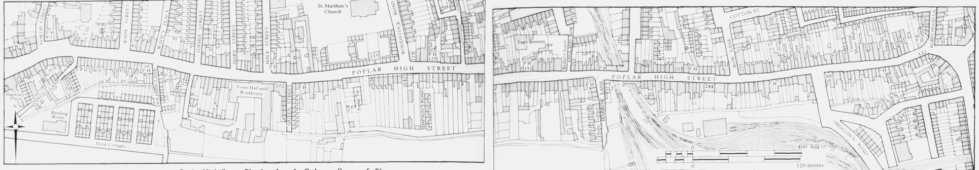
Poplar High Street. Plan based on the Ordnance Survey of 1867–70
The 'stonebridge' of 1452 is also referred to in 1590, (fn. 16) and the 'Stonebridge pond' mentioned in the 1650s was evidently a watering place for horses and cattle in front of the site of the present-day White Horse public house. (fn. 17) The bridge presumably carried the way from Limehouse over the 'black ditch' or sewer that came down from the north between what were later Nos 15 and 17, and perhaps over associated boggy ground. The western part of the street was designated 'Stonebridge Pond' by Joel Gascoyne on his map of 1703 and the term was still in manorial use as late as 1788. (fn. 18)
The signs of early development at the rather 'busy' north-west end of the High Street, at the junction with North Street, are perhaps still discernible in the rather confused hinterland shown on the 1867–70 Ordnance Survey map. On the south side of this western part of the street was manorial waste which in 1500 had been called, doubtless from its use, the Butts, but which was built over by 1586. (fn. 19)
The four ways shown on the 1573 map are: Dolphin Lane (sometime Grigg's, Gutt or Angel Lane) between Nos 68 and 70 (in the post–1865 numbering); Harrow Lane (sometime Chapel or King's Lane) between Nos 210 and 212; Preston's Road (sometime Clifton's Lane) between Nos 286 and 288; and the precursor of Blackwall Way at the eastern end of the street. The last of these was important as leading to the embarkation places at Blackwall, but Harrow Lane was also of importance as the main way southward through the Isle of Dogs to the Chapel of St Mary's and Potter's Ferry. The fifth, more westerly, way was Dingle Lane (sometime Heath's or Butts Lane) between Nos 30 and 32, which existed by 1652. (fn. 20)
At that time the herbage of this and the other ways (called by the hamlet authorities in 1812 'the old manor ways') (fn. 21) was claimed by the manor of Stepney. (fn. 22) In the nineteenth century, however, the properties at the top of the west side of Harrow Lane belonged to the manor of Poplar, and this may imply an old affiliation to that manor of the lane itself, as it led to the chapel formerly belonging to the Abbey of Graces on Tower Hill, which had owned the manor of Poplar. The tenure of much of the street by one or other of these manors until the early twentieth century was a factor in its development, and in the degree to which that development can be adequately recorded.
In the nineteenth century the property of the manor of Poplar lay on the south side of the street, chiefly west of the workhouse. (fn. 23) Some of the territory was disputed. In 1652 the frontage westward of Dolphin Lane – the Butts mentioned above – was claimed for the manor of Bromley (also known as the manor of Poplar), but the Parliamentary Survey of that year preferred a claim on behalf of the manor of Stepney: (fn. 24) in 1728, however, it was freehold, said to be formerly of the manor of Poplar. (fn. 25) When the almshouse site, bought for the East India Company in 1627, was sold to the Poplar District Board of Works by the India Office in the 1860s there was confusion whether it was copyhold or not (see page 108). The manors were not, of course, mutually exclusive in their copyholders – the Dethicks, for example, who were important landholders in and around the High Street in the sixteenth to early eighteenth centuries, were copyholders of the manor of Stepney but also lessees of the 'manor house' of the manor of Poplar. The Dethicks' property under the manor of Stepney lay on both sides of the boundary between the hamlets of Poplar and Limehouse, and their successors in ownership, the Hale family, thus developed or redeveloped property in both areas.
The buildings on the property of the manor of Poplar at the west end of the south side were humble and unambitious, like the smaller property west of Harrow Lane further east. But it is difficult to establish a direct connection between manorial tenure and unaspiring development (or lack of development): Commodore Court, on freehold land, and Collins Place, on copyhold land, were equally unsatisfactory. Nor did manorial tenure necessarily mean short leases: the builders at and behind Nos 165–177 in 1774 had a 99–year building lease, the lessee of garden ground at and behind Nos 125–129 in 1791 a 61–year lease (both under Stepney manor), (fn. 26) and the builder of Derby Terrace an 80–year lease in 1855 (under the manor of Poplar), (fn. 27) but none of these resulted in noticeably superior developments (any more than did the builder's 90-year lease of Simpson's Road in 1855 on freehold property). (fn. 28) The copyhold west side of Hale Street built under 31–year leases seems to have been rather more respectable than Queen Street, built on the same owner's freehold.
Whether copyhold or freehold, a characteristic of landownership in the High Street from at least the early eighteenth century onwards was its subdivision into many hands. One instance is the Dethick property, which in 1724 was in the hands of five children of Henry Dethick and was surrendered in the manor of Stepney in favour of nine incoming owners, of whom only one was a member of that family. (fn. 29) How far this tendency to multiplication of ownership was the effect of the ancient custom of gavelkind in respect of inheritance from an intestate copyholder of the manor of Stepney is hard to say. Nevertheless, the regularity with which incoming copyholders of that manor surrendered their holdings immediately upon their admission 'to the use of their will' suggests that there was a general exercise of testamentary control in order to avoid the operation of gavelkind, by which a tenant's inheritance was divided equally among his or her sons, or, if there was none, among the daughters. For whatever reason, it seems that there were many small 'landlords' in the street. In 1714 the 78 residents whose rates were paid by a landlord had 23 between them; in 1784 the 254 houses particularized in the ratebooks had 122 owners (only 28 of whom were also occupants); in 1817 the south side of the street alone was divided among 71 owners (as distinct from lessees or occupants); and in 1840 the 274 houses in the ratebooks had 141 owners. (fn. 30) A similar situation still prevailed in the twentieth century. In 1909–15 the 173 houses for which there is information had 97 different owners; (fn. 31) in 1935, when the London County Council bought 33 sites for redevelopment at Nos 41–105, it dealt with 14 separate owners; and 31 houses bought by the Council in 1947 52 had had 12 owners. (fn. 32) Despite the small units of ownership, it was not uncommon for owners to hold sites on both sides of the street.
On the manor of Poplar in the years 1810–39 the lord's property in the street (perhaps some 50 houses) brought him an income arising out of the 'fines' or premiums on the renewal of holdings that was immensely variable but which averaged just under £100 per annum. (The most, in 1837, was £649.) (fn. 33)
The incidence of manorial tenure and the small units of ownership make the story of the street difficult to tell from documents, particularly in view of the paucity of manorial records in the sixteenth century. The difficulties are increased by one effect of the poverty of the inhabitants, which was that many of them appeared only intermittently, if at all, in the records. Mary Williams, of whom the land tax collector wrote 'not paid ye Queens Tax for some years excused by the Gentlemen', (fn. 34) was one of many 'Gaffers' and 'Gammers' so treated. Of the 672 properties listed in the hearth tax returns of 1664 for the whole of Poplar, some 239 were not chargeable; (fn. 35) by the 1720s rival polemicists seem to agree that nearly two-thirds of the hamlet's 600 or so houses were either empty or otherwise not chargeable for poor rates; (fn. 36) and in 1766 the minister of the chapel reported that 300 of his chapelry's 500 tenements were in the same situation. (fn. 37) Moreover, these poor occupants were, it seems, usually omitted altogether from the ratebooks. So although a fairly continuous sequence of rate–or assessment-books is available from the 1690s, these 'hidden' and changing gaps make it a very imperfect tool with which to establish the identity of house-sites over a period of time.
As far as it can be deduced from a miscellany of title deeds and other sources, the type of house-owner in Poplar High Street did not change greatly between the sixteenth and nineteenth centuries. Many of them had addresses in Poplar itself, elsewhere in East London (including south of the river) or in the City (and far fewer in other parts of London). Those living in Poplar were often building tradesmen, publicans or shipwrights. The owners from East London and the City were similarly tradesmen rather than professional men: it may be that some of the 'gentlemen' became so as a perquisite of lending money. More recently the local provenance of owners was – again not surprisingly – modified. Of 97 names in the Inland Revenue's valuation in 1909–15 only 17 lived in Poplar: many lived in other parts of London, but comparatively few outside London. (fn. 38) A third of owners were women, (fn. 39) and in the nineteenth century and later public authorities buying land here often found themselves dealing with executors or trustees of small estates perhaps a symptom of the tendency for heirs to retain unremunerative properties rather than pass them into an active market.
There were four units of ownership in the street worthy of further scrutiny. In 1694–5 a John Hale was a taxpayer on the north side of the street in the vicinity of what much later was Hale Street. (fn. 40) He was probably the carpenter who built a house on the south side of the street by 1701, and in 1709 leased a property adjacent to his north-side site to a shipwright. (fn. 41) In 1715–16 he gave way in the High Street to an Owen Hale, (fn. 42) also a carpenter, presumably the son of John, who was described in 1727 as house-carpenter of Ruislip, deceased. (fn. 43) Owen himself was dead by the following year, possessed also of property in Limehouse, which he left with his Poplar property to his brother Henry, described as 'gentleman'. This was copyhold of the manor of Stepney, and since 1724 had included property on the south side of the street opposite the main holding that had, like the Limehouse property, previously been owned by the Dethicks. (fn. 44) Henry enfranchised the south-side property in 1757. (fn. 45) He was dead by 1779 and his property passed (by Owen's will) to his son John and two daughters, one of whom was married to a carpenter in the City and the other to a prominent Poplar lawyer, John Salter, notary public. (fn. 46) John Hale was himself a carpenter in the City, off Cannon Street. He seems to have acquired effective ownership from his relations and from him the property on both sides of the High Street descended by 1803 to his builder son, Thomas (in a trust with his mother). (fn. 47) It was Thomas Hale, one of the first would-be developers, with Thomas Ashton of Blackwall, of the east end of East India Dock Road in 1807–8, who finally subjected the property to development in the first decade of the nineteenth century. This was chiefly in Hale Street and more humbly in Queen (later Bickmore) Street, and on their flank fronts to the High Street, but apparently without rebuilding some adjacent Hale frontages to the street at Nos 97– 105. He died in 1822 and his bachelor son Thomas died in 1858, whereupon the property was dispersed among the latter's many sisters: the chief representative in 1903 was a son of one of these, Claude Hale Pontet, a retired civil servant living, with one of his sisters, at Wandsworth Common. (fn. 48)
Westward of the Hale property on the north side of the street and only a little later in emerging was the much larger estate of the Wade family, which covered 52 acres and had a frontage to the High Street extending from No. 27 to No. 87. This was acquired in 1717 by Jeremiah Shirbutt, a butcher of Whitechapel (but since at least the 1690s a ratepayer in Poplar), (fn. 49) who was evidently, from his will, a Quaker. In 1719 he gave a long lease of it to a cowkeeper at £120 per annum, (fn. 50) and in 1721 made a marriage settlement of the property on his daughter and her husband John Wade. (fn. 51) By 1747 it was in the ownership of John Wade's son, Jeremiah Shirbutt Wade, a ship's carpenter. In 1755 the estate was mortgaged for £1,500. In 1775 it was owned by Jeremiah Shirbutt Wade's son, of the same name, a carpenter. (fn. 52) From then on the family were the ratepayers for the big, old house on their property, the 'manor house' of Poplar manor, and for its more modern replacement, until 1854. (fn. 53) The land continued in agricultural or horticultural occupation. (fn. 54) Jeremiah Shirbutt Wade was later describing himself as a gardener and in 1800 leased the land to a market gardener for 21 years. (fn. 55) Some building went on at Nos 41–47 in 1805–10. (fn. 56) Wade died in 1806, leaving a widow and five daughters. (fn. 57) Gradually the High Street frontage was built up between 1806 and the mid–1820s: (fn. 58) the hinterland was developed unsatisfactorily until after Mrs Wade's death about 1821, when her daughters and their husbands created a revised layout (see page 171).
Smaller and less notable as a property-holding was the site of Nos 70–86 on the south side of the street with its more extensive hinterland behind the workhouse site. This became the property of the Collet (later Sanderson) family by purchase in 1737 and was retained in part until the 1860s (see page 77). There was no redevelopment of the High Street frontage, despite the fact that the Sanderson owner in 1837 was a carpenter in City Road, and a part of it was sold to a local builder in 1847.
A holding of later origin but more significance was that of the Stock family. John Stock first appears as a ratepayer, at No. 151, in 1788, moving in 1794 to No. 119, (fn. 59) where he ran a boys' school, the Poplar House Academy. Two or three years later he bought it and the largely undeveloped land opposite (extended westward in 1812) comprising the sites of Nos 126–154, and by the 1850s the family had a wide spread of properties in Poplar. (fn. 60) The will of John Stock's son Edward in 1852 particularizes this little East End empire in nearly a score of locations in Poplar, mainly north of the High Street, as well as other properties in Limehouse and at Plaistow and East Ham. (fn. 61) Apart from the sites abutting on the High Street, they were mainly just one or two houses. They ranged down from houses in the High Street and Mountague Place to a few in Woolmore Street and a row of arches under the Blackwall Railway. Only a short time before his death in 1852 Edward began the redevelopment of the High Street sites, carried on thereafter by his son Edward Wood Stock, a solicitor, of Plaistow and Lincoln's Inn Fields. This was coincidental with the departure of the Stocks from their residences in the street, and on the south side some of the property at least was made available for development by freehold sales. The level of development thus varied from poor, when developed under leases from one of Edward Wood Stock's purchasers, to moderate, when Stock granted leases in Woodstock Terrace, where his architect brother Henry was involved. At the same time the wider scatter of properties in Poplar was divided among Edward Stock's other children. (fn. 62) The Rev. John Stock, a clergyman in Leicestershire, owned a house here and others nearby at his death in 1905. (fn. 63)
These four ownerships share some common elements. Development of the property came late – even though three of the families had some connection with the building business. The possession of the estates, whether developed or not, seems to have brought only a modest, if any, advancement in social status for the owners. And in three of the instances the property was eventually dispersed among the children of large Victorian families.
Although in many small ownerships, the houses in the High Street were for the most part emphatically not 'owner-occupied'. The evidence of the ratebooks of 1784 and 1840 suggests that perhaps one in seven was so occupied. It was a street of small 'landlords', some of them on the high seas, like Captain (later Admiral) Richard Lestock, who in 1714 had a 'Deputy Landlord' to receive his rent and pay his rates for him on the south side. (fn. 64) In 1909–15 the proportion occupied by the freeholder was about one in thirteen and more than half were occupied by weekly tenants. (fn. 65)
This short-term tenure is the more notable as almost all the properties were occupied as houses-with-shops, except where institutional use of some kind had established itself. (fn. 66) Consistent with occupation by shopkeepers, the 1881 census shows that the heads of households in the street were not very young (in their mid-forties) and the houses not much subject to multi-occupation or even greatly overcrowded (on average five or so persons per house). Only one in nine of the heads of households had been born in Poplar. But the street was in these respects probably not typical of the district – nor in the presence of some kind of 'servant' in one household in six. (fn. 2)
In so far as the street was 'slummy' in the late nineteenth century, it was probably more so in the small courts off it than in the street itself, however shabby and poverty-stricken it became. It was in the courts that tiny houses were put up, often in about the first decade of the century. These were so badly constructed, subject to damp, and ill-ventilated that they became unfit for human habitation in the eyes of Poplar's Medical Officers of Health, even when they were not, as they usually became, grossly overcrowded. They had often been built by local men – sometimes builders or publicans – and although the freehold might pass into other hands, the immediately rent-receiving owner would often be a local man in a humble way of life. The supply of the demand for housing at the lowest level was thought remunerative, and from mid-century the 'Regency-period' courts were supplemented by privately built blocks of lodgings or flats.
Within the period for which there is some information, the history of the fabric is generally of decay, and title deeds suggest that the division of houses into smaller units of occupation was appreciably more frequent than the replacement of small houses by a larger one.
As far as styles are concerned the picture is, of course, mixed. The imposing house built at the site of No. 119 in 1715 was up-to-date and so in a more modest way were Nos 162–164 of the 1790s and Nos 126, 196–200 and 227–233 of the 1820s. Weatherboarding survived well into the twentieth century. Unfortunately, some of the most attractive features of the fabric are virtually undatable – the shopfronts. The Rococo specimen of unknown location, very similar to the well-known example at No. 88 Dean Street, Soho, and partly recorded in a sketch (fig. 12); the flat late-Georgian front at No. 314, with its restrained joiner's work and more lavish fanlight; and the Roman Doric portico at No. 225 are all of unknown date. So too is the trio of great shallow bowwindows, like an incongruous 'Quality Street' stage set, at Nos 97–101 (Plate 2b). Each, however, seems likely to represent a more or less up-to-date taste. On the other hand the style of some buildings could fairly be described as belated, as at No. 15, built in 1854, and, probably, at the surviving Nos 246–254.
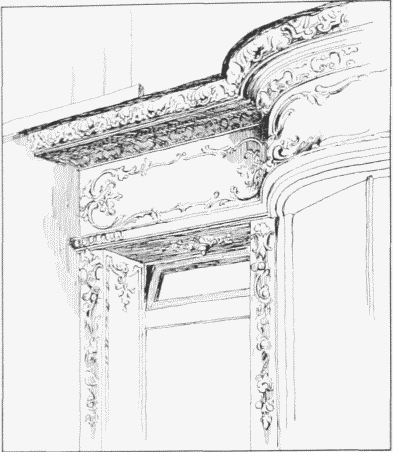
Poplar High Street. Sketch of part of an unidentified shop-front c1890. Demolished
In the opening decade of the nineteenth century, when the great enclosed docks were made, there was a building boom of a kind in the High Street. But the three ratepayers in gaol and the fourth transported to Botany Bay in 1803–6 (fn. 67) point to the 'mixed' character of the street, and much of the augmentation of its fabric was at a very low level, where a number of little enterprises were undertaken to provide cramped back-courts for occupation by labourers. The general London building boom of the mid–1820s is faintly reflected and in 1824 the parish authorities noted that several houses were about to be taken down. (fn. 68) The up-to-date appearance of some of the replacements has been noticed. Among the houses built on the south side in the 1850s, though they were 'of no architectural merit', (fn. 69) some were professionally occupied, and this seems to signify a short time when the prospects for residential property in the street had some faint promise, with local poverty alleviated by the Crimean War boom in shipbuilding, a time when 'the whole Isle of Dogs rang with hammers from morning to night'. (fn. 70) The Poplar Literary and Scientific Institution was here (behind Nos 186–188) in 1845–52, before moving to East India Dock Road. (fn. 71) In Poplar generally far more new houses were built in 1845–55 than in 1871–91 and the High Street reflects this. There were 51 new houses built in the 11 years 1845–55, 18 in 1872–82, nine in 1883–93, nine again in 1894–1904, but none in 1905–15. Rather similarly, new shopfronts numbered 19 in 1845–55, three in 1872–82 and nine in 1883–93. (fn. 72) Unlike East India Dock Road, the narrow High Street, although it housed some early nineteenthcentury dissenting congregations, never attracted architecturally imposing places of worship to its frontages.
Since 1817 much of the street had lain within the metaphorical and some of it in the physical shadow of the big workhouse building on the south side. Nor were the attractions of the street enhanced by the trades pursued there, such as the 11 slaughterhouses in 1859, (fn. 73) the cork-burner at No. 100 in 1899 and the haddock-dryer at No. 302 in 1881. (fn. 74) At and behind No. 25 the nineteenth-century sawmill was succeeded by chain-makers and repairers whose ironworks continued there after the Second World War. (fn. 75) The hold on 'amenity' was very frail and by the end of the nineteenth century the street was thoroughly depressed, with 'several houses of ill-fame, frequented by common seamen', on its south side. Will Crooks's biographer spoke in 1907 of the 'now silent' High Street, (fn. 76) and the Inland Revenue's valuation of 1909–15 shows the silence to have been one of decay and neglect. (fn. 77)
Nineteenth-century house-prices at 30 sites have been noted. These suggest that in the first half of the century, for the small house-with-shop, they were in the range £60–£150: after the first decade some prices fell. Prices in the 1880s were appreciably higher; for example they were £425 each at Nos 227–233. (fn. 78) Throughout the century the prices of property sold to public authorities were inflated.
Few figures for the cost of building are known. A three-storeyed house and shop over a basement at No. 266 with a frontage of about 20ft was tendered for in 1859 at £525, (fn. 79) a group of three houses at Nos 137–141 (frontage 14ft each) in 1878 at £1,287, (fn. 80) and a new brick front (of about 17ft) at No. 110 in 1895 at £777. (fn. 81)
Hardly anything is known of the shops in the street's earlier days. A case in the Court of Exchequer in 1626 gives some information about a chandler's shop in Poplar selling 'Nuttmegs, Otes, ginger, spices'. It was probably in the High Street as it was said that customers came to it from 'the furthest end of the towne'. The complainant had taken the shop for three years at £2 or £3 per annum. Witnesses mention that there were three other chandler's shops within half a mile. It is of interest that neither the owner nor the lessee was resident. The owner lived in Stepney and the lessee (whose complaint was that the owner had spoilt his trade by taking one of the other chandler's shops himself) did not run his shop personally. He had an estate at North Weald Bassett and employed an apprentice to manage (in fact, to mismanage) the shop for him: indeed he seems to have been a small one-man 'conglomerate', having also a tailor's shop on lease from the same owner. (fn. 82)
Emslie's views in the 1870s show how much the High Street was then a shopping street (Plates 3a, 151a). But they probably show a street where retail prosperity was already in decline. Commentators attributed this to the departure of street-traders and costermongers to Chrisp Street, from the late 1860s onwards. (fn. 83) The removal of the Poplar Railway Station to East India Dock Road in 1865–6 had probably made matters worse. By 1895 the City Press called it 'one of the worst paying thoroughfares in London'. (fn. 84) From 1872 to 1900 few new shopfronts are noticed in the district surveyor's returns. There was then some increase, to 1915. But the Inland Revenue's valuer was driven to constant comment in his assessments of 1909–15 that this was 'a bad business street'. (fn. 85)
As for the shops themselves, by the 1930s they shared one predominant characteristic with the rest of London's humbler shops: the division of the ground floor between the shop itself at the front and a separate 'shop parlour' behind, whence the proprietor would emerge at the tinkle of the shop bell. Access to the shop parlour and the rooms above was usually via the shop not via a separate street-door. Some shops of this kind were of very simple design. No. 22, built in 1876, had its shop parlour as its only living-room and of the two bedrooms above one opened out of the other. (fn. 86)
Taverns were an early feature of Poplar, doubtless because of its function as a waiting place for water-borne travellers. Seven alehouses were licensed in Poplar in 1519 (fn. 87) and six (all to 'yeomen') in Poplar as distinct from Blackwall in mid-century. (fn. 88) In the early to mid-nineteenth century the High Street had about seventeen licensed public houses plus eight beershops. (fn. 89) The publican was sometimes a man of enterprise and some of the street's lamentable back-courts were generated in the yards of public houses. Some taverns were licensed for music and dancing: in the late 1860s there were four of these, all on the north side. (fn. 90) At least two had rooms set aside for the purpose, and one of these (later the Queen's Theatre) developed into a full-blown music hall with the auditorium and bars conveniently adjacent. In the 1880s and 1890s about a third of all the building work in the street was given to its public houses, (fn. 91) and between 1894 and 1899 three (the Spotted Dog, the White Hart and the Blakeney's Head) were rebuilt. (fn. 92) One public house, the White Horse, rebuilt in 1927–8, retains the name and site it had in 1690.
The public houses latterly stood out from their neighbours by reason of their relatively good repair. In surveys taken in 1909–15 the Inland Revenue's valuer found seven out of ten buildings in the street to be in bad condition, (fn. 93) and in the mid-1930s rebuilding along the street was given priority by Poplar Borough Council because of the dilapidation of the properties. (fn. 94) This began to alter the character of the street, which was further eroded when more than a third of the houses were either destroyed or seriously damaged during the Second World War. (fn. 95)