A History of the County of Essex: Volume 9, the Borough of Colchester. Originally published by Victoria County History, London, 1994.
This free content was digitised by double rekeying. All rights reserved.
A P Baggs, Beryl Board, Philip Crummy, Claude Dove, Shirley Durgan, N R Goose, R B Pugh, Pamela Studd, C C Thornton, 'Modern Colchester: Town development', in A History of the County of Essex: Volume 9, the Borough of Colchester, ed. Janet Cooper, C R Elrington( London, 1994), British History Online https://www.british-history.ac.uk/vch/essex/vol9/pp199-208 [accessed 27 July 2024].
A P Baggs, Beryl Board, Philip Crummy, Claude Dove, Shirley Durgan, N R Goose, R B Pugh, Pamela Studd, C C Thornton, 'Modern Colchester: Town development', in A History of the County of Essex: Volume 9, the Borough of Colchester. Edited by Janet Cooper, C R Elrington( London, 1994), British History Online, accessed July 27, 2024, https://www.british-history.ac.uk/vch/essex/vol9/pp199-208.
A P Baggs, Beryl Board, Philip Crummy, Claude Dove, Shirley Durgan, N R Goose, R B Pugh, Pamela Studd, C C Thornton. "Modern Colchester: Town development". A History of the County of Essex: Volume 9, the Borough of Colchester. Ed. Janet Cooper, C R Elrington(London, 1994), , British History Online. Web. 27 July 2024. https://www.british-history.ac.uk/vch/essex/vol9/pp199-208.
In this section
TOWN DEVELOPMENT
Nineteenth-Century Growth 1835-1914
Colchester was able to avoid the extreme environmental and health problems suffered by many other towns in the 19th century because its population and industry expanded comparatively gradually, and there was space for growth. Between 1835 and 1911 the number of houses increased from 3,292 to 9,218, more than 2½ times, in a similar proportion to population growth. In 1835 buildings were concentrated in the central area within and around the town wall, with some ribbon development along the roads leading out of the town, especially on those leading eastwards towards Greenstead and the Hythe. The rest of the borough was mainly rural. (fn. 1) The topography was particularly affected by the barracks, built south of the town centre from 1855 onwards. (fn. 2) Residential and industrial development was modest. In the mid 19th century smaller houses, mainly in terraces, were built south and east of the town wall often on poorly drained low ground, and larger houses on more desirable sites to the west, beginning a spatial segregation of the social classes which had previously lived close together in the central area. A few houses were also built near Colchester North railway station and in gaps along the main roads. (fn. 3) Between 1876 and 1914 the rate of house-building increased, there was significant industrial and commercial development, and the barracks were extended; (fn. 4) by the first decade of the 20th century house completions averaged 187 a year. (fn. 5) Almost all development was south of the river Colne, which, reinforced by the railway line, formed a natural barrier between the town centre and the north part of the borough. Under public health legislation the improvement commissioners, and from 1874 the borough council, provided drainage, improved streets in the town centre, investigated industrial and other nuisances, inspected slum houses, and approved plans for new building, but town planning and wider housing powers remained permissive before the First World War. (fn. 6)
In 1845 J. P. Osborne laid out plots with frontages varying from 14 ft. to 50 ft. on his garden land, part of the Blue Posts estate, in Osborne Street south of the town centre between Stanwell and St. Botolph's Streets. In the same year new streets on Golden Acre field, on the east side of North Street near the new Colchester North railway station, were laid out for houses. (fn. 7) By 1848 terraces of working-class houses had been built in Essex, Chapel, Wellington, and South Streets, south of St. John's Street. (fn. 8) The Botanic Gardens east of the castle were to be sold in 1851, and by 1852 the National Freehold Land Society, which was affiliated with the Liberal party, had bought them and small plots had been laid out there in Castle and Roman Roads by T. Morland and C. Wilkinson; 72 lots were bought by builders, other craftsmen, merchants, and a few gentlemen, 41 of them from Colchester, the rest from the London area. (fn. 9) In the 1860s Morland and Wilkinson laid out another small estate west of North Station Road just south of the Eastern Counties' asylum consisting of Belle Vue, Colne Bank, and Essex Hall Roads, and in 1863 Meyrick and Pownall Crescents were developed by a Conservative land society. (fn. 10)
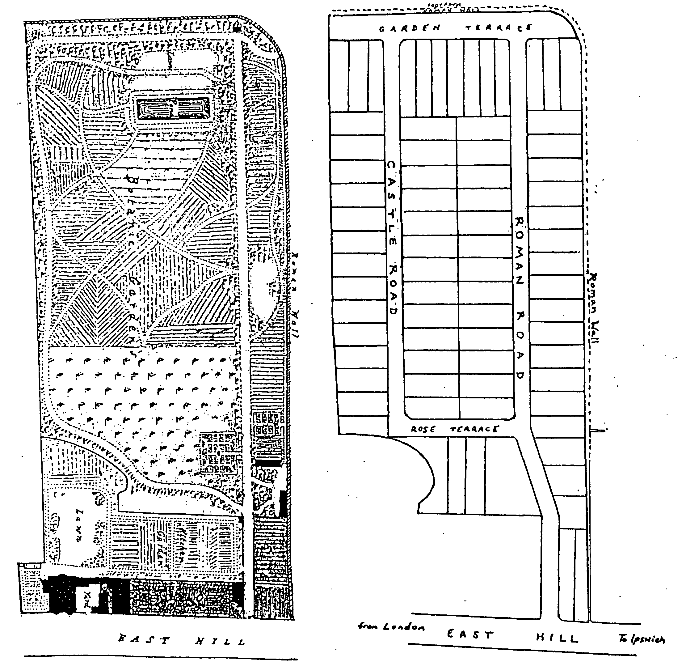
The botanic gardens, 1847, and their development, 1852 (scale approximately 1 : 2687)
Demand for substantial houses on the west side of the town was considerable. There had been scattered development along both sides of Lexden Road in the early years of the 19th century and in 1817 the town clerk, Francis Smythies, had built a castellated villa, probably from designs by Robert Lugar, at the end of the high ground overlooking Lexden village. On the north side of the road the two parts of St. Mary's Terrace introduced a further element of architectural distinction. The west terrace of c. 1825 has five pairs of semidetached houses which are linked by low recessed stable blocks. The east terrace of 1837 by H. H. Hayward is a single architectural composition with accented centre and ends. Both developments were set back from the road behind gardens. (fn. 11) In the third quarter of the century there was rapid development along those new cul de sacs on the south side of the road. (fn. 12) The houses are of a variety of styles and materials but are on generous plots. Blatch (later Wellesley) Street with Blatch Square, 'a spacious square planted with ornamental trees', were built south of Crouch Street, between Maldon Road and the Essex and Colchester hospital, from 1865, (fn. 13) and the West Terrace estate of large villas in the road later called The Avenue before 1868. (fn. 14) The large plots marked out often carried stipulations about development. Public houses were prohibited on the Beverley estate when plots and houses were being sold in 1874, (fn. 15) and a similar concern had been shown for the quality of development on a site near the Turrets in 1864. (fn. 16) The result was a distinctive suburb of medium size and large houses and gardens, still in the 1880s surrounded by fields.
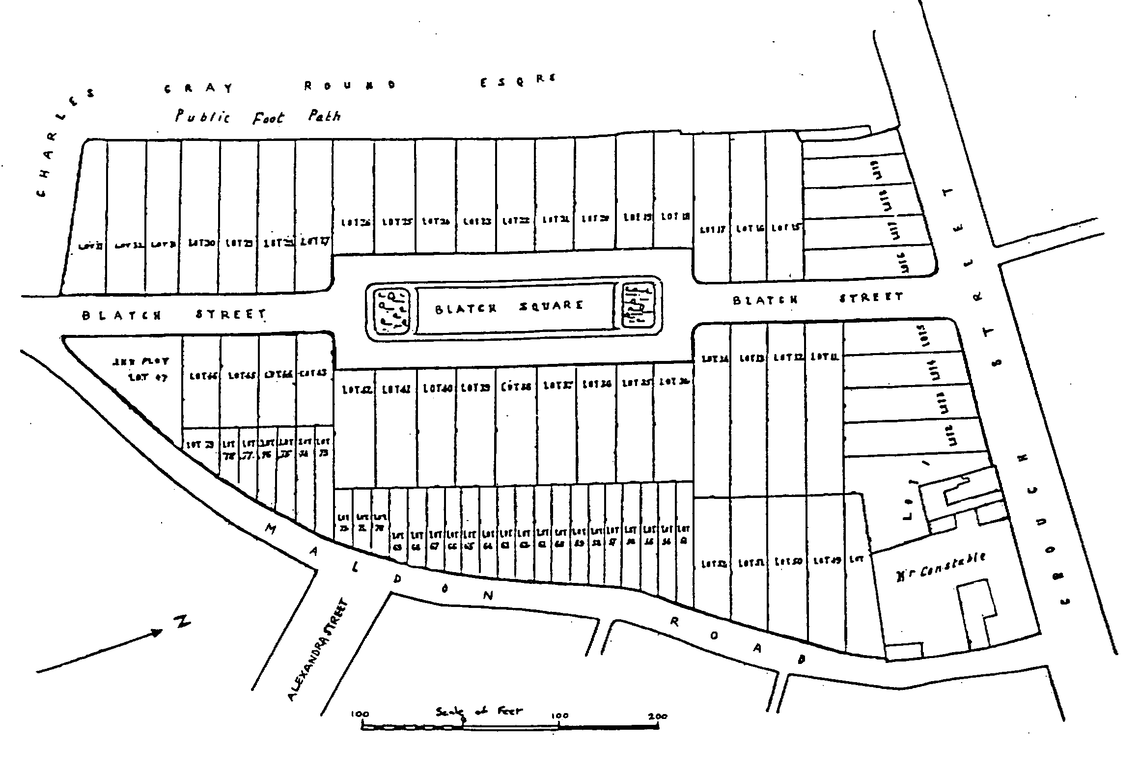
Blatch Square, 1865
After 1876 a further area between Lexden and Maldon Roads was developed: the executors of Charles Gray Round sold part of Hospital farm on the Creffield estate in 1876 and 1878, and spacious detached houses were built in Creffield, Oxford, Gray, and Hospital Roads; (fn. 17) Walter Chambers, a local builder, developed Cambridge, Victoria, Fitzwalter, and St. Clare Roads, and he also owned houses in the south and east quarters of the town. (fn. 18) North of Colchester North station and the new railway laundry, a small number of semidetached houses was built from 1878 on the Three Crowns estate off Bergholt Road, (fn. 19) and further houses were built along the Bergholt Road and in gaps along other main roads. (fn. 20) Between Butt and Maldon Roads Henry Jones laid out Salisbury and Beaconsfield Roads from 1879 on the Mill Field estate, (fn. 21) and before 1914 other roads were built as far south as Constantine Road. (fn. 22) The Papillon family sold land south of the workhouse, formerly part of Lord's land, in the 1880s, and Rawstorn Road and neighbouring streets were built; many employees from Mumford's engineering works in Culver Street lived there. (fn. 23)
Most growth, however, was at New Town, developed from 1878 south of the road to the Hythe, a large compact area between army land on the west and Paxman's engineering factory at the Hythe on the east: 293 houses were built there by 1885. (fn. 24) Morant, Harsnett, and King Stephen Roads were built there on the Wimpole estate between Wimpole Road and Park Lane from 1899, and Claudius, Campion, Lisle, Barrington, and part of Canterbury Roads on the Goldwell's estate (previously occupied by Bunting's nursery) on the south side of the barracks from 1901. (fn. 25) J. F. Goodey, a local builder, other members of the Co-operative movement, and local Liberals were influential in the development of New Town, hence the name Gladstone Road. The intention was to create a social mix through the provision of varied housing. Goodey himself, who specialized in precast concrete architectural detail, lived in a detached house, New Town Lodge, in New Town Road. (fn. 26) Terraced houses, with some better ones for foremen, were laid out on a gridiron road pattern and higher quality houses were built on the southern periphery in Granville and Gladstone Roads or in terraces overlooking the recreation ground.
Building societies played an important role in the expansion of the housing market. The Colchester Permanent Benefit building society, founded in 1856, and the Colchester Co-operative Mutual Permanent Benefit building society, founded in 1869, later the Colchester Equitable building society, advanced money to members to buy houses either to live in themselves or as an investment. Money was lent to women on the same terms as men, and by 1878 the number of working-class borrowers was increasing. By 1894 the Colchester Equitable had advanced £115,000 on 630 cottages, 28 businesses, 7 large houses, and 1 chapel, mostly in the town or the immediately surrounding area. (fn. 27) Colchester Co-operative Society also enabled some of its members to become owner-occupiers. In 1879, with surplus capital, it bought some plots on the New Town estate, built four cottages on them, and allotted them to members who paid for them by easy instalments; four more cottages were provided soon afterwards, and likewise four in 1884 in Rawstorn Road and four in 1886 in Pelham Road. (fn. 28)
Much new housing was of a good standard, but overcrowded and insanitary older accommodation remained, often around confined courtyards, particularly in the centre, and east and south of the town, and that facilitated the spread of infectious diseases. (fn. 29) The road from the town to the Hythe was notorious for poor housing. (fn. 30) In 1898 the medical officer of health considered that some new houses, built quickly and cheaply and sometimes on unfavourable sites, were so small that they created fresh overcrowding. (fn. 31)
In the 19th century most of the old and new trades and industries were carried on in workshops, factories, and foundries in the town centre and the Stanwell Street area, and there were breweries at East Hill and North Hill. Later in the century when there was insufficient land available for industry in the central area, some new factories were built further out, like Paxman's opened at the Hythe in 1873 and George's shoe factory built in New Town in 1881. The Hythe, with its wharves and warehouses, had always been important for the port trade, but from the mid 19th century new industry was increasingly located there: the gasworks were built in 1838, the sewage works in 1884, and four new engineering factories between 1899 and 1907. Shops, inns, and commercial services were concentrated in the town centre. As trade increased and more space was required for business, some residents moved out of the central area: between 1831 and 1901 population fell in St. Nicholas's and St. Runwald's and remained almost the same in St. Martin's, all central parishes, while it increased in all other parishes. Corner shops, bakeries, and new public houses were built in the new streets beyond the town centre to serve the people living there and the soldiers from the barracks. (fn. 32)
The number of public buildings increased as the town grew. The grammar school moved in 1853 to new buildings by H. H. Hayward on the south side of Lexden Road, and many new schools were built, including the board schools by Goodey and Cressall in Barrack Street in 1896, at St. John's green in 1898, and in John Harper Street in 1900. (fn. 33) St. Botolph's church was rebuilt in 1837, St. Mary Magdalen's in 1854, and St. Michael's Mile End in 1854-5, and new churches were built: St. John the Evangelist's Ipswich Road in 1863, and St. Paul's Belle Vue Road in 1869. Most other churches were restored. New landmarks in the town included the workhouse on Balkerne Hill opened in 1837, the Essex and Colchester hospital opened in Lexden Road in 1820 with its later extensions, the Eastern Counties' asylum at Essex Hall built originally as a railway hotel, and at Mile End in the north the infectious diseases hospital and Severalls lunatic asylum opened in 1884 and 1913. (fn. 34) Jumbo, the water tower built in 1883, became a dominant feature of the town, and provided a new view at the west end of High Street. (fn. 35) There were significant changes in High Street: a new town hall replaced the old moot hall in 1845, and was itself replaced by another new building in 1902; the Albert hall was built at the west end in 1845, originally as an additional corn exchange. (fn. 36) A new corn exchange was built next door to the town hall in 1884. (fn. 37) High Street was cleared of some obstructions: the obelisk was removed in 1858, the cattle market was relocated at Middleborough in 1862, and Middle Row shops and St. Runwald's church were demolished in 1857 and 1878. (fn. 38) The tramway system also affected the appearance of the streets on the tram routes from 1904. (fn. 39)
By 1914, despite the increasing rate of building, no one lived further than about a mile from open space, and patches of market gardens still punctuated the built-up area. Countryside could still be seen from parts of the town centre because of its higher elevation. New streets had been built on the Botanic Gardens, and St. John's abbey garden was acquired by the army, but additional public open space was provided when the recreation ground was opened on the edge of New Town in 1885, and Castle park in 1892. (fn. 40) The army kept the Abbey field and Middlewick rifle ranges free of building, and the Round family preserved the Bury field south of East Hill House. (fn. 41)
Twentieth-Century Growth 1914-92
Between the two World Wars the population increased by c. 10,000, the built-up area spread outwards, and the town lost its earlier compactness. The extensive Lucas estates in Mile End and Greenstead were sold in 1917 and small portions of glebe land were sold in 1918 at Mile End, St. Leonard's parish, Old Heath, and off Lexden Road, in 1920 at Mile End, and in 1922 at Monkwick; some of that land was used for building, although some of it continued as farmland until after the Second World War. (fn. 42) In 1921, when the population was 49,393, there were 9,053 occupied houses. (fn. 43) Local development was increasingly affected by central government legislation for housing and town planning. Between 1921 and 1938 much of the residential development was municipal housing in large planned estates, but there was also considerable private building in small estates, ribbon development, and in-filling, with totals of 1,029 council and 2,141 private houses. (fn. 44) The barracks expanded further, the army reserving for military use two wedges of open space in the south, between Butt and Mersea Roads and between Mersea and Old Heath Roads. Employment opportunities attracted people from neighbouring areas, some of whom moved into houses in the town. Increasing traffic congestion in the town centre was alleviated from 1933 by a new bypass north of the town, and some firms moved to sites alongside the new road. The bypass, the sections of which from west to east were known as Cymbeline Way, Colne Bank Avenue, Cowdray Avenue, and St. Andrew's Avenue, reinforced the barrier already created by the river and the railway between the town centre and the north part of the borough, and most development between the wars was in the south.
The town council, employing a mixture of direct labour and local building firms, built four housing estates between the wars to central government specifications on borough land at Mile End and on private farmland bought at Lexden on the borough boundary south of Lexden Road, at Old Heath, and between the Harwich and Ipswich roads. (fn. 45) Other council houses were built in smaller groups, like those on a site north of Castle park. (fn. 46) Nevertheless council house-building could not meet the demand for inexpensive rented houses, and the Lexden Garden Village Ltd. was formed as a public utility society to provide family homes at a reasonable rent. It raised loans from the local council and issued shares paying modest rates of interest. The scheme, initiated by Capt. R. L. Reiss, Labour parliamentary candidate for Colchester, and G. C. Bensusan-Butt, both inspired by the Garden Cities movement, was managed by men 'of all opinions and politics' who gave their professional services free. Eighty-six houses had been completed by 1926 on 40 a. bordered by Grimes Dyke on the west, Lexden Road on the north, and Lexden Straight Road on the east, but in 1927, when money for further building was not forthcoming, the remaining 9½ a. were sold to the council which built 93 houses. The Lexden Garden Villages Ltd. remained as a public company until the late 1970s when all the houses were sold, mostly to the tenants. (fn. 47)
Private detached and semidetached houses were built in new roads, mostly west, south-west, and south-east of the town centre. Gladwin Road, between Maldon and Layer Roads, may have been typical: in 1927, Leonard Dansie, an estate agent and auctioneer, bought the first plot, employed his own builder to build a detached house, and moved into it; a few other houses were built in the same way; then Everett's, a local firm, bought the remaining plots, built semidetached houses all of the same design, and sold them separately. (fn. 48) There was also further ribbon development along main roads, including the new bypass, and spaces were filled in existing roads, farmers often being glad to sell roadside plots to speculative builders in a time of low agricultural prices. (fn. 49) Local planning regulations were drawn up before 1939, but their implementation was halted by the war. (fn. 50)
After the Second World War increased commuting, both outwards to London and inwards from towns and villages nearby, affected the expansion of the town; many commuters moved into new houses in the borough to live nearer their work. Wartime bomb damage had been slight, but some slum clearance and new building was necessary to reduce overcrowding. Because there was still plenty of space, building at high density and in high-rise blocks was not undertaken as in some other places, and Colchester was selected by Essex county council as a town for expansion. (fn. 51) Between 1945 and 1961 a total of 6,147 public and private houses were built, so that by 1961, when the population was 65,080, there were 20,229 dwellings (of which 19,825 were occupied). (fn. 52)
In the late 1940s and the 1950s the council housed 3,600 people in 1,250 new houses on 95 a. at Shrub End in the south-west corner of the borough and 3,500 people in 1,150 houses at Monkwick in the south; it also built a few houses and flats at Prettygate, north of Shrub End. Some shops, schools, and churches were provided for the new estates. (fn. 53) Private housing lagged behind public housing immediately after the war because of government restrictions. Between 1945 and 1953 only 452 private houses were built, but the number increased to 2,327 between 1953 and 1961. The first large private estate was built, mainly by W. A. Hills & Son, a local firm, in the late 1950s on 260 a. on the Home Farm and Prettygate estates in the west and south-west parts of the borough. Other developments included the war department's large Montgomery estate, built on 200 a. south of the barracks in the 1950s and 1960s. The army also built flats in 1970 in Lethe Grove near the military corrective centre, which had been built at Berechurch in the mid 1950s. There were also smaller private developments, including those off Mersea Road, west of Lexden Park, north of Colchester North railway station, between Ipswich Road and the railway, and north of East Hill, and there was much infilling. (fn. 54)
From 1955 large-scale development began north of the river with the building at Greenstead of the borough's largest council estate, most of which had been built by the mid 1960s, with infilling continuing until 1985, providing about 2,800 homes. The council also built a further 220 houses nearby at Parson's Heath. (fn. 55) The local council had in the 1950s successfully resisted the use of Greenstead for London overspill population, (fn. 56) but in 1974 in spite of local opposition the Greater London Council bought directly from Fairview Estates 128 private houses on the Birch Glen estate. (fn. 57) Colchester council took over those houses in 1988 after the abolition of the Greater London Council. By 1992 about a third of all council houses had been bought by their occupants, principally under the Housing Act of 1980. (fn. 58)
St. John's private housing estate was built in the 1960s in the north-east quarter of the town. Other private developments included the low-density Link homes erected on a 5.6 a. site at Welshwood Park nearby in 1972-3. (fn. 59) There was a building boom in the early 1970s, (fn. 60) but planning policies by the mid 1970s no longer designated north-east Essex as a major or medium growth area. Instead planners gave priority there to agriculture, conservation, and countryside protection, and tried to restrain Colchester's growth to allow public amenities to catch up with housebuilding. (fn. 61) From the 1960s large national firms were increasingly involved in building in the borough. In 1979 French Kier began developing the 730-a. High Woods site west of the Ipswich Road, to provide c. 4,000 houses and a shopping centre. (fn. 62) There was other small-scale council and private building, including small developments by housing associations like that between Forest Road and Avon Way at Greenstead in 1977 by the C.D.S. Co-operative Housing Society Ltd., (fn. 63) bringing the total of council and private dwellings in Colchester urban area to 36,542 by the end of 1991; the population was 91,817 in 1989. In 1981 owner-occupiers formed 61 per cent of households and council tenants 25 per cent. (fn. 64)
Some of the earlier housing stock had been improved from the 1950s and there had been a little slum clearance, mainly in the 'twilight' zone around the town centre, used as car parks before being redeveloped; (fn. 65) some houses were demolished in Vineyard Street in 1962 to provide parking. (fn. 66) By 1965 there were 2,045 parking spaces, (fn. 67) and in 1966 a multistorey car park was opened in Nunn's Road. (fn. 68) Seventeenth-and early 18th-century houses in the 'Dutch Quarter', north of High Street, were renovated between 1955 and the 1980s to create a convenient residential area in the town centre; by 1984 the council had taken over 35 older buildings there and provided 147 new flats and 17 houses to blend with the older ones. (fn. 69) From 1971 there were several improvement schemes, covering St. Mary's, New Town, South Town, and Magdalen Street, to upgrade the housing stock by allowing grants to tenants for undertaking major repairs and modernization. The council improved street lighting, planted trees and shrubs, and restricted parking. (fn. 70)
Industry and commerce were after 1945 increasingly located on specific sites beyond the town centre; in 1991 the main centres were at Severalls Park, the Hythe, Cowdray Avenue, and North Station Road, and smaller ones were mainly east of the town centre and on the south-west periphery of the town. (fn. 71) Nevertheless concern grew about the problems of traffic congestion, and also about haphazard development and demolition in the central area, (fn. 72) such as the demolition of St. Nicholas's church in 1955 for a new Co-op department store, and of the Cups public house in 1972. (fn. 73) Colchester Civic Society was set up in 1964 to try to halt losses of that sort by encouraging higher standards in planning and design and by arousing public interest in the preservation and improvement of local amenities. (fn. 74) A report of 1968 on the town centre, amended by Essex county council in 1969, contained proposals for the following 14 years to redevelop the Lion Walk, Culver Street, St. Peter's Street, and St. John's Street/Vineyard areas, to make the town centre a conservation area, to build an inner relief road system and peripheral multistorey car parks, and to pay special attention to the needs of pedestrians and public transport. (fn. 75)
By 1984 parts of the plan had been amended because of financial constraints and the new preference for improvement and small-scale rather than comprehensive redevelopment. Some activities were moved out of the town centre: in 1975 the cattle market went from Middleborough to Severalls Lane, and a new swimming pool and sports centre were built in Catchpool Road on the south side of Cowdray Avenue. In the central shopping area a new public library was built, replacing the one opened in Shewell Road in 1948, some houses were converted into small shops in Trinity Street in 1975, and the Lion Walk shopping precinct was opened in 1976. Four office blocks were built in St. Peter's Street by 1976 to provide municipal offices and a telecommunications centre. (fn. 76) The southern and western sections of the new inner relief road were finished by 1981, cutting through existing road patterns and neighbourhood areas and causing the demolition of 107 houses, 50 shops, 32 other businesses, 4 factories including the Colchester Manufacturing Co. and Hollington's, the Elim church, a warehouse formerly the Empire cinema, and 4 public houses, the Carpenters Arms in Chapel Street, the old Essex Arms in Essex Street, the Plough in St. Botolph's Street, and the Woolpack at St. Botolph's Corner. (fn. 77) Multistorey car parks were built at Queen Street in 1972 (closed in 1992 because of structural faults), St. John's Street in 1977, Middleborough in 1980, and Balkerne Hill (St. Mary's) in 1981. (fn. 78) The appearance of the shops changed as chain stores with fronts in their own house-style came to dominate the streets and shopping precincts. Between 1968 and 1980 total commercial floor space increased by 45 per cent in the central area, with an increase of 35.6 per cent in the number of non-food shops and a decrease of 11.9 per cent in the number of food shops. (fn. 79) After the publication of the central area local plan of 1984 the Culver Street shopping precinct with 47 shopping units built by the Carroll Group was opened in 1987, and St. John's Walk shopping centre of 18 units and Osborne Street car park in 1990. (fn. 80) A large supermarket was included as part of the Highwoods development in the north part of the borough and another at Stanway beyond the ancient borough's western boundary.
Many more schools and churches were built in the period from 1914, but some of the previously existing ones were converted to other uses in the later 20th century. Community centres and neighbourhood shopping parades were built on many new estates after 1945. Other new landmarks included the war memorial designed by H. C. Fehr and completed in 1923, Hythe generating station opened at the Hythe in 1927, the Turner village part of the Royal Eastern Counties' Institution in the 1930s, the new technical college (later Colchester Institute) at Sheepen Road in 1959, Essex University at Wivenhoe Park in 1961, the new Goojerat barracks in the early 1970s replacing the old ones, the Royal London offices at Middleborough in 1982, county council accommodation at Stanwell House in 1985, the District General hospital in 1985, offices and housing beside Colchester North railway station in the late 1980s, the new police headquarters alongside Southway in 1989, and the leisure centre at Cowdray Avenue in 1991. Among earlier buildings demolished were the Hythe gasworks in 1973 and the former asylum at Essex Hall in 1985. (fn. 81)
The need to preserve some open space and to provide pleasant views became more important as the built-up area grew. Braiswick golf course north-west of the town, founded in 1909, remained free of development. The council established sports grounds and children's play areas on sites all over the borough and created artificial lakes in Castle park in 1973. The cemetery in Mersea Road was extended and landscaped, covering more than 57 a. (fn. 82) Trees were planted in 1931-2 along the western part of the bypass to create an Avenue of Remembrance, one section commemorating former citizens including 25 former mayors, the other servicemen who died in the First World War; two other avenues were planted, one in honour of the Girl Guide movement, the other called a Children's Avenue. (fn. 83) The council prohibited building on the southern slopes of the Highwoods site and on some woodland nearby, and in 1988 opened High Woods country park as public open space. (fn. 84) In 1990 the council bought from Essex county council part of Lexden park, opening it to the public in 1991 as a nature reserve. (fn. 85) In 1992 some land at the southern and northern extremities of the historic borough was still agricultural. Thus, although the built-up area of the town had increased greatly in the 20th century, a significant amount of space remained free of buildings, and, because of the varied elevations of different parts of the town, many views of open land were retained.