A History of the County of Lancaster: Volume 5. Originally published by Victoria County History, London, 1911.
This free content was digitised by double rekeying. All rights reserved.
'Townships: Blatchinworth and Calderbrook', in A History of the County of Lancaster: Volume 5, ed. William Farrer, J Brownbill (London, 1911), British History Online https://www.british-history.ac.uk/vch/lancs/vol5/pp227-229 [accessed 30 April 2025].
'Townships: Blatchinworth and Calderbrook', in A History of the County of Lancaster: Volume 5. Edited by William Farrer, J Brownbill (London, 1911), British History Online, accessed April 30, 2025, https://www.british-history.ac.uk/vch/lancs/vol5/pp227-229.
"Townships: Blatchinworth and Calderbrook". A History of the County of Lancaster: Volume 5. Ed. William Farrer, J Brownbill (London, 1911), British History Online. Web. 30 April 2025. https://www.british-history.ac.uk/vch/lancs/vol5/pp227-229.
BLATCHINWORTH AND CALDERBROOK
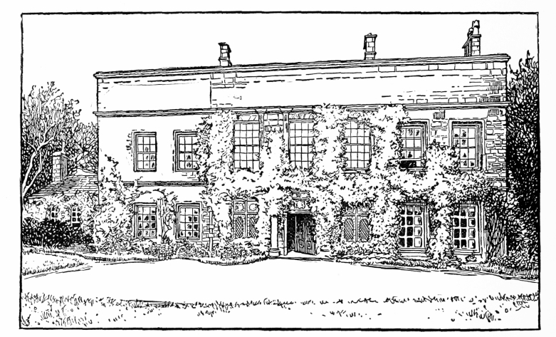
In this part of Hundersfield there were a number of ancient estates, some of which, as Sladen (fn. 1) and Lightollers, (fn. 2) gave surnames to the proprietors; but the most prominent is a comparatively recent one, that of PIKE HOUSE, near Littleborough, the possession of the Halliwells and their successors from the latter part of the 16th century. (fn. 3) The present owner is Captain Clement Robert Nuttall Beswicke-Royds. Pike House stands on high ground on the lower slope of Blackstone Edge, about half a mile north-east of Littleborough, facing south-west. It is a stone-built house of two stories, with attics, erected about 1608–9 in the place of an older building, but greatly altered and modernized a hundred years later, when the present ashlar front with large sash windows was added, and many alterations made in the interior. The original 17th-century house had three gables on each front facing north and south, the roofs running through from front to back, and these still show on the north side, where the elevation is not much changed. The old roofs, which are covered with stone slates, still remain behind the high 18th-century parapet on the principal front. The north side preserves also many of the original 17th-century mullioned and transomed windows and a large projecting chimney, though the east gable has been replaced and other changes have taken place. Over one of the later windows is the date 1704, probably the year when the alterations were carried out and the new front added. The refacing of the front elevation, which is 65ft. in length, appears to have been done at two different times, the centre portion and east end being recased first and the west gable at a later date, the stonework being plainer and the windows less in height. The three upper middle windows have thin pilaster strips on either side, breaking round the stringcourse above, and the door is flanked by columns and has a panel with a blank shield and cornice above, but apart from this the elevation is quite plain and without architectural distinction. The height of the parapet, determined by the gables behind, is excessive, and viewed from the ends, where it shows as a screen wall above the roof, is very ugly. The windows retain their original wood bars. Internally the house preserves traces of its 17th-century plan, though most of the arrangements and fittings belong to the 18th-century remodelling. The light oak panelling of the dining-room is exceedingly good, and of simple and dignified detail. The staircase, which has carved oak balusters and square newels, and the breakfast-room fireplace are also good examples of 18th-century work. In the kitchen is a wide open fireplace under a low arch, and another fireplace, the great chimney of which is such a noticeable feature of the north elevation, seem to have originally belonged to the entrance hall, which occupies the middle portion of the ground floor. The windows on each side of the front door contain modern heraldic glass, and the large staircase window is also filled with heraldic and pictorial glass illustrating the history of the families connected with the house. The principal rooms on the first floor open from a corridor running the whole length of the building, and there is a low single-story addition at the west end. Originally the road ran much nearer the east end of the building, and two stone piers in front of the house mark the entrance to a former flower garden.

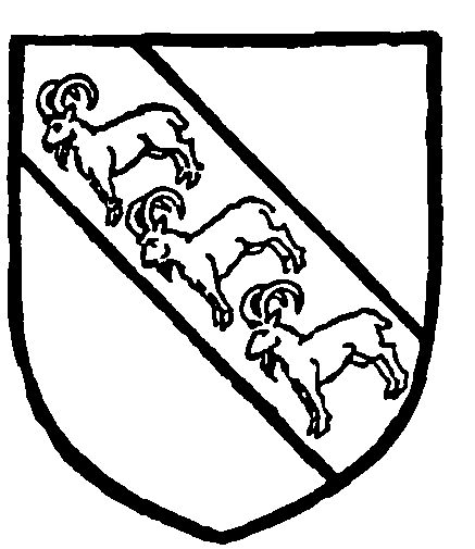
Halliwell of Pike House. Argent on a bend gules three antelopes of the field attired or.
SHORE was anciently in part a possession of the Hospitallers; it gave a name to some of the tenants. (fn. 4) The house now called Handle Hall was the home of the Dearden family, now lords of the manor of Rochdale. (fn. 5) Windy Bank (fn. 6) and Town House (fn. 7) are other old estates.

Pike House, Littlelorough
The house known as Windy Bank stands in a fine position above the road near to the ancient packhorse track leading over Blackstone Edge. It is a picturesque two-story stone-built house [capital letter L]-shaped in plan, the long front facing south and the short arm running north at the east end. The principal elevation has three flush gables with long low mullioned windows with hood-moulds over. At the east end is a large projecting chimney, and at the south-east angle a large roughly-carved gargoyle in the form of a man holding open his mouth with both hands. Over the door are the initials I.B. (John Butterworth) and the date 1635, and there was formerly a sundial in the middle gable, traces of which still remain. The house is now let in tenements, and the interior has been remodelled and is without interest. (fn. 8)
Lower Town House was rebuilt in 1604, and an illustration of it in the 18th century shows a picturesquely grouped two-story gabled structure with farm buildings adjoining. This building was pulled down in 1798 when the present house—a plain 18th-century stone building with sash windows—took its place. Over a door in the servants' hall is a carved stone from the old house with the initials ' R.N. W.N. 1604,' and in more modern characters 'W.N.B. rebuilt 1798.' In the wall of one of the outbuildings is a stone bearing the Newall arms and the initials and date, ' L.N.S. 1752.' (fn. 9)
Robert Holt of Stubley and John Belfield of Littleborough were among the landowners in 1626. (fn. 10) At that time there were 1,134 acres of copyhold land. The chief landowners in 1797 were Mr. Dearden, Mr. Newall, Colonel Chadwick, and Mr. Beswicke. (fn. 11)
On the west side of the high road at Steanor Bottom, near Calderbrook, is a three-story stone house with
mullioned windows, along the front of which is a long
ornamental panel (fn. 12) with carved border and quaint
inscriptions:
NO MAN ON
EARTH CAN TE
LL THE TORMENT
THATS IN EL
A S E 1700
BY MANY
STROKES THE
WORK IS DONE
THAT COVLD
NOT BE PER
FORMD BY ONE
The initials refer to one of the Eastwood family.
Apart from the inscriptions the house is architecturally
without interest.