A History of the County of Lancaster: Volume 6. Originally published by Victoria County History, London, 1911.
This free content was digitised by double rekeying. All rights reserved.
'Townships: Simonstone', in A History of the County of Lancaster: Volume 6, ed. William Farrer, J Brownbill (London, 1911), British History Online https://www.british-history.ac.uk/vch/lancs/vol6/pp496-503 [accessed 30 April 2025].
'Townships: Simonstone', in A History of the County of Lancaster: Volume 6. Edited by William Farrer, J Brownbill (London, 1911), British History Online, accessed April 30, 2025, https://www.british-history.ac.uk/vch/lancs/vol6/pp496-503.
"Townships: Simonstone". A History of the County of Lancaster: Volume 6. Ed. William Farrer, J Brownbill (London, 1911), British History Online. Web. 30 April 2025. https://www.british-history.ac.uk/vch/lancs/vol6/pp496-503.
In this section
SIMONSTONE
Simundestan, c. 1230; Simondiston, 1258; Symoundeston, 1327; Symonstant, Symonstone, xiii cent.; the forms with 'd' inserted were the more usual; the termination 'stan' is found in 1292. The local pronunciation is Simmonston.
This township occupies part of the southern slope of a long ridge to the north of Padiham and Nelson. Going northwards from the Calder, which forms the southern boundary, the surface rises from about 230 ft. above the ordnance datum to over 800 ft. The village lies to the south-west of the centre; Huntroyde, with its extensive demesne, is on higher land to the north and east. A considerable part of the eastern boundary is defined by Huntroyde Brook, which runs down a wooded clough to join the Calder. Simonstone Brook flows south through the centre of the township. The area is 1,026 acres (fn. 1); there was a population of 491 in 1901.
The principal road is that through the village, joining Whalley and Padiham; another road between the same places runs about a mile to the north. Near the southern boundary is the road from Padiham to Blackburn. A cross-road connects these three. The Lancashire and Yorkshire Company's loop line from Blackburn to Padiham and Burnley crosses the lower ground in the south, and has a station named Simonstone.
The soil is clayey with subsoil of clay and rock. The land is in pasture. In 1552 there is mention of coal-getting on the king's waste of Simonstone. (fn. 2)
The township is governed by a parish council.
Manor
In the 13th century SIMONSTONE is found to be a member of the honor of Clitheroe and held in thegnage by a number of local families. It appears to have been assessed as 5 oxgangs of land, and in 1258 four parts rendered 12s. 9½d. a year to the lord, while the remaining fifth part—Huntroyde—was held by the service of a pair of spurs or 2d (fn. 3) The lordship of the manor, with one of the oxgangs, was inherited or acquired by Robert de Holden, (fn. 4) who in 1311 held it by the yearly rent of 3s. 2½d. at the Feast of St. Giles and suit to the three weeks court of Clitheroe. (fn. 5) Soon afterwards the manor descended to his son Nicholas, (fn. 6) who died about 1344, leaving his son Robert to succeed him. (fn. 7) Robert was living in 1399, (fn. 8) and was in 1411 succeeded by his grandson Thomas Holden. (fn. 9) Randle Holden occurs in the reign of Edward IV. (fn. 10)
William Boswell (fn. 11) of Chevet in Royston died in 1513 holding messuages and lands in Simonstone of the king as of his manor of Clitheroe in socage by a rent of 8d. for puture of the bailiffs of the forest of Pendle. The heirs were his daughters Elizabeth wife of Sir John Nevill, aged twenty-eight, and Alice wife of Robert Nevill, aged twenty-six. (fn. 12) On a partition the 'manor of Simonstone' became the share of the younger daughter, (fn. 13) and was in 1566 sold by her son George Nevill of Ragnell to John Braddyll, (fn. 14) who at his death in 1578 was found to have held it in socage. (fn. 15) His son and heir Edward obtained a confirmation of the manor from John Nevill, the son of George, (fn. 16) but appears to have sold it in 1596 to John Whitaker. (fn. 17) Nevertheless the manor is named in the inquisitions after the death of Edward Braddyll in 1607 and his son John in 1612; but the tenure is not stated. (fn. 18) From that time this manor disappears from the records.
The Whitaker family or families had long been settled in Simonstone, (fn. 19) and in 1599 Miles Whitaker sold a moiety of the manor, with a moiety of the water-mill, and lands, &c., to Roger Nowell of Read. (fn. 20) The Nowells had already some land in Simonstone, (fn. 21) and Roger at his death in 1624 was found to have held a messuage and land of the king in socage, nothing being said of a share of the manor. (fn. 22) The Whitakers have continued to hold an estate in Simonstone. (fn. 23)
SIMONSTONE HALL is a two-story stone-built house with gables, mullioned windows and stone slated roofs, built probably in the early 17th century, but very much modernized and of little architectural interest. The principal front, which faces west, has two gables with spiked ornaments, and a third recessed gabled wing at the north end, while the east elevation shows three flush gables. The front windows have all rounded heads to the lights, but appear to be early 19th-century restorations; those at the back being later are better in detail. Over the door is a shield with the arms of Whitaker with helm, crest and mantling. The interior is wholly modernized and without interest.
Other holders of land used the local name, but the descents cannot be traced clearly. (fn. 24) Ravensden gave a name to its holders. (fn. 25) Among the names recorded in pleadings and inquisitions are those of Shuttleworth, (fn. 26) Walmesley, (fn. 27) Hargreaves, (fn. 28) Lowe, (fn. 29) Lonsdale (fn. 30) and Robert or Roberts (fn. 31)
A partition of the wastes made in 1629 shows that the following were freeholders:—Richard Shireburne of Stonyhurst, Richard Shuttleworth of Gawthorpe, Roger Nowell of Read, John Starkie of Huntroyde, Thomas Whitaker, John Whitaker, John Robert, Edmund Cockshott, George Whitaker, Thomas Lonsdale, Christopher Whitaker, Robert Sagar and Richard Mercer, all of Simonstone. (fn. 32)
HUNTROYDE was part of the land granted about 1230 by John de Lacy as lord of Clitheroe to John de Thelwall, by the description of a fifth part of the vill of Simonstone; a spur or 2d. was to be the annual service. (fn. 33) John de Thelwall's descendants were usually styled 'de Simonstone' (fn. 34); and in 1311 it was found that John son of John de Simonstone held an oxgang of land in thegnage of Henry de Lacy, and rendered yearly a pair of spurs of the value of 1½d. and suit to the three weeks court of Clitheroe. (fn. 35) The estate descended regularly in this family, receiving sundry additions, (fn. 36) until about 1460, when the heiress, Elizabeth, married Edmund son and heir of William Starkie of Barnton, near Frodsham, and carried it to the family which still retains it. (fn. 37)
Edmund Starkie died in 1511 holding the fifth part of the town of Simonstone of the king in socage by the rent of two spurs, and leaving a son James, aged twenty-four years. (fn. 38) In 1558 it was declared that the land was not held by knight's service. (fn. 39) The estate descended regularly, (fn. 40) and was increased by the marriage of Nicholas Starkie with the heiress of John Parr of Kempnough, (fn. 41) and of John Starkie with Alice Norris of Tonge. (fn. 42) The family appear to have been Puritans. John Starkie, son and heir of the above-named Nicholas, (fn. 43) was a member of the Presbyterian Classis in 1646. (fn. 44) As Colonel Starkie he took an active part on behalf of the Parliament in the Civil War, (fn. 45) and it was his son, Captain Nicholas Starkie, who was killed by the explosion after the capture of Hoghton Tower in 1643. (fn. 46) The eldest son of John and Alice Starkie inherited Huntroyde, (fn. 47) but his son Piers dying without issue in 1760, (fn. 48) this part of the estates went by will to the issue of a younger son Nicholas, who had been a prominent lawyer about 1700. (fn. 49) From Nicholas's grandson, Le Gendre Starkie, (fn. 50) Huntroyde has descended regularly to the present owner, Major Edmund Arthur Le Gendre Starkie, (fn. 51) who succeeded his father, Colonel Le Gendre Nicholas Starkie, in 1899.

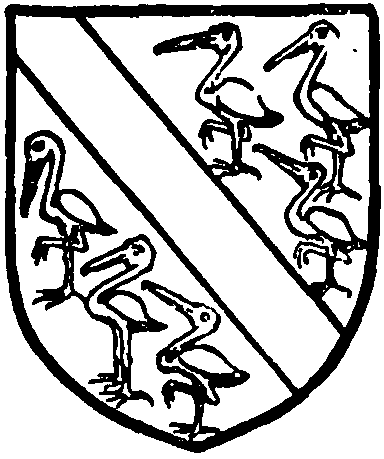
Starkie of Huntroyde. Argenta bend sable between six storks proper.
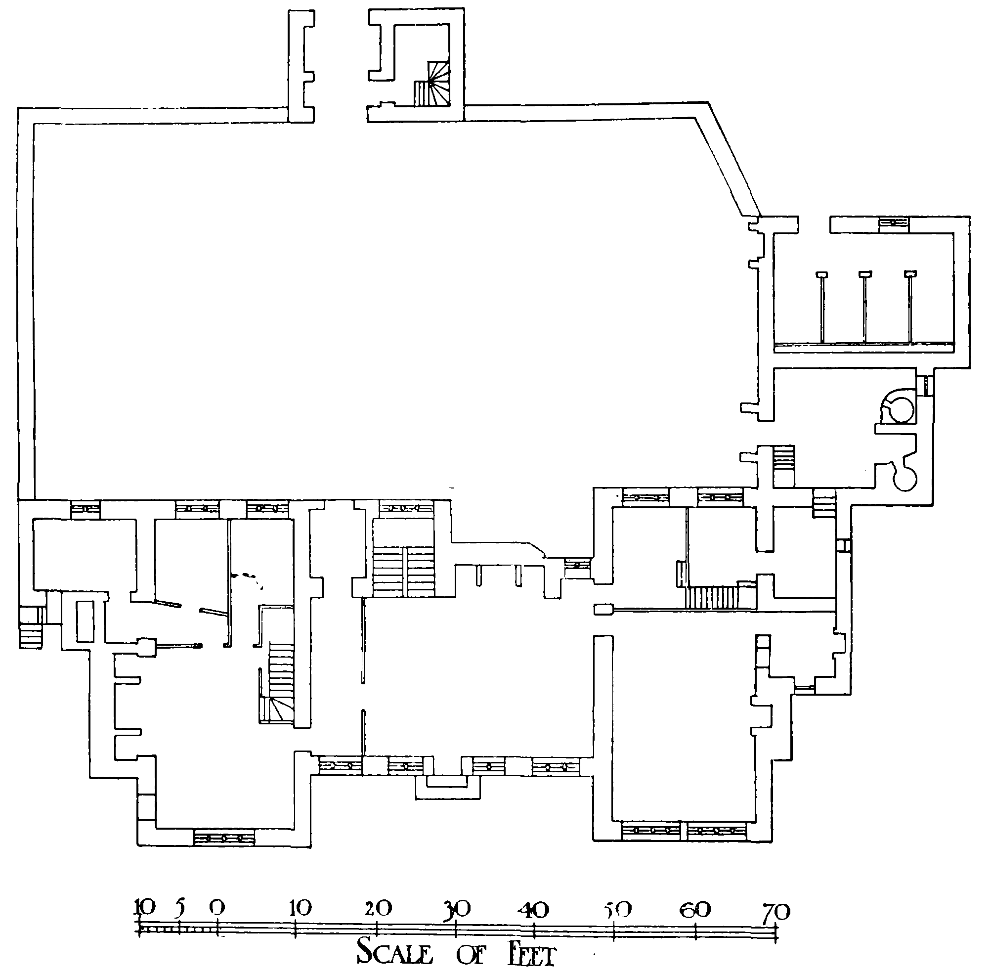
HUNTROYDE stands close to the eastern boundary of the township about a mile to the north-west of Padiham, and is a large house built at three separate periods and altered and added to at the close of the last century. A plan and elevation of the old building, (fn. 52) portions of which still remain, show it to have been a 16th-century house following the usual type with central hall and end projecting wings, and having a total frontage to the south of 80 ft. The hall was 35 ft. by 20 ft., including the passage behind the screen at the west end, and was directly entered by a door, without porch, in the middle of the south wall with two windows on each side. The original arrangement, however, was probably slightly different from that shown in the plan, alterations having apparently been carried out in the 17th century, to which period probably the central doorway and the flanking windows belong. (fn. 53) A stone still preserved at the back of the house over the door leading to the kitchen court has the date 1576 with the initials E.S., and there is a similarly inscribed stone on the front near the ground at the south-east angle of the west wing. The date most likely gives the year of the first building on the site, which was of two stories with mullioned windows and plain gables to the wings, which projected 8 ft. A small gate-house, 22 ft. by 14 ft., appears to have been erected in 1631 at a distance of 47 ft. on the north side, forming the entrance to a courtyard about 92 ft. in length inclosed by walls. On the east side of the court, however, according to the 18th-century plan, were stables and other outbuildings, probably a new wing erected at the same time as the gate-house or shortly after, and attached to the original east wing of the house.

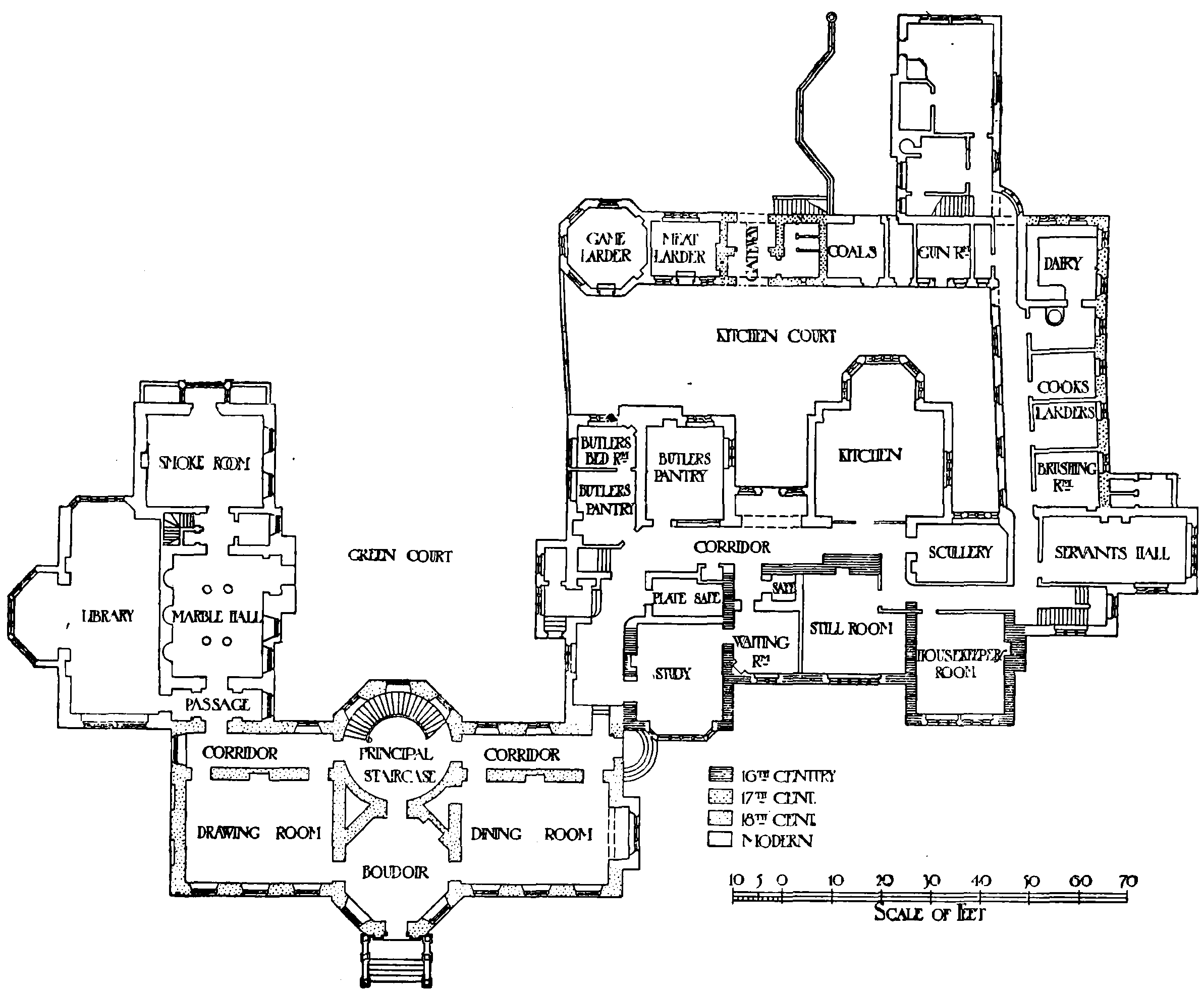
Plan of Huntroyde
In 1777 a large new wing was erected attached to the south-west angle of the old building, standing in front of it its full width of 35 ft., and such alterations were made to the older portion of the house as were required by the necessities of the new wing. This 18th-century building, which is 92 ft. long and planned on the regular classic lines of the time, contains on the ground floor a drawing-room and dining-room each 30 ft. by 21 ft., on either side of a central octagonal apartment opening to the garden with a circular staircase hall behind, from which a corridor runs along the north side of the rooms. The central feature projects as a wide bay on south and north, and the building, which is of a very plain character, with square sash windows, embattled parapets and hipped roof, is of two stories, the walls being of squared ashlar blocks on a low rusticated base. (fn. 54) A long servants' wing running northwards from the east wing of the old house appears to have been erected shortly afterwards, (fn. 55) and the elevation of the old building underwent some alteration, the plain gables and wall between being 'ornamented' by battlements and sash windows were introduced.

Plan of Huntroyde, 1777
In 1850 (fn. 56) a large wing containing a library and entrance hall supported by marble pillars was added at the north-west of the 18th-century building, running northwards some 64 ft. and forming the third side of a courtyard open to the north. In 1879 a range of offices was erected to the north side of the kitchen court incorporating the old gatehouse, which was restored; and in 1885–8 the whole of the old 16th-century building underwent yet another restoration, the front being wholly refaced, the sash windows removed and larger mullioned windows substituted, while many additions and alterations were made on the north side, including the erection of a lofty billiard-room on the first floor. The greater part of the exterior elevation of the house, which is built entirely of stone, is therefore modern and has little architectural interest. The 18thcentury central block remains unaltered, but is externally a singularly unattractive and dull example of the taste of the day, the square unmoulded battlements, if original, giving it a pseudo-Gothic appearance more usually met with fifty years later. The interior, however, contains some very good Adam decoration.
Very few of the original features of the old building remain inside, but in one of the bedrooms is a fireplace dated 1668, and a large stone fireplace now built up and some of the old stone doorways yet remain on the ground floor. The interior of the house is, however, generally speaking, without antiquarian or architectural interest. The house contains some old furniture, including an oak chest, oak dresser, and four-post bed, all bearing the initials of Grace Murgatroyd, the wife of Nicholas Starkie, who perished in the explosion at Hoghton Tower in 1642–3.
Over the archway of the rebuilt gate-house a dated stone inscribed 'J.S. 1631 M.S.' has been retained, and on the lawn in front of the house is a 17thcentury stone sundial, similar in design to one at Loveley Hall, with the initials I.H. T.T. on the shaft, but undated, and with a new plate.
The hearth tax in 1666 found fifty-eight hearths in Simonstone liable. The largest houses were those of John Starkie and John Cockshott, each with eight hearths. Miles Whitaker's house had five, three houses had four and two had three hearths. (fn. 57)
The land tax return of 1789 shows that Le Gendre Starkie and Thomas Whitaker were the principal owners. (fn. 58)
There is no place of worship in Simonstone, but divine service has for many years been conducted by the vicar of Padiham in the National schoolroom.