A History of the County of Wiltshire: Volume 13, South-West Wiltshire: Chalke and Dunworth Hundreds. Originally published by Victoria County History, London, 1987.
This free content was digitised by double rekeying. All rights reserved.
Jane Freeman, Janet H Stevenson, 'Parishes: Sedgehill', in A History of the County of Wiltshire: Volume 13, South-West Wiltshire: Chalke and Dunworth Hundreds, ed. D A Crowley (London, 1987), British History Online https://www.british-history.ac.uk/vch/wilts/vol13/pp169-176 [accessed 30 April 2025].
Jane Freeman, Janet H Stevenson, 'Parishes: Sedgehill', in A History of the County of Wiltshire: Volume 13, South-West Wiltshire: Chalke and Dunworth Hundreds. Edited by D A Crowley (London, 1987), British History Online, accessed April 30, 2025, https://www.british-history.ac.uk/vch/wilts/vol13/pp169-176.
Jane Freeman, Janet H Stevenson. "Parishes: Sedgehill". A History of the County of Wiltshire: Volume 13, South-West Wiltshire: Chalke and Dunworth Hundreds. Ed. D A Crowley (London, 1987), British History Online. Web. 30 April 2025. https://www.british-history.ac.uk/vch/wilts/vol13/pp169-176.
In this section
SEDGEHILL
SEDGEHILL (fn. 1) lies on Wiltshire's boundary with Dorset 5 km. north of Shaftesbury and measured 480 ha. (1,185 a.). (fn. 2) It is entirely on Kimmeridge Clay, land most suitable for meadow and pasture. (fn. 3) There has never been much ploughing and no nucleated settlement has developed. Sedgehill was a tithing in the later 13th century, (fn. 4) and a church seems to have stood there in the earlier 14th. The church was dependent on that of Berwick St. Leonard, 8 km. north-east of it, from 1395 to 1585 and from c. 1661 to 1914, (fn. 5) but Sedgehill relieved its own poor and was a civil parish in the 19th century. (fn. 6) In 1986 the parish was amalgamated with Semley to form the parish of Sedgehill and Semley. (fn. 7)
In the mid 11th century the lands which became Sedgehill parish were possibly part of the Tisbury portion of Shaftesbury abbey's Tisbury estate. (fn. 8) In the early 12th century they belonged to Shaftesbury abbey and were sufficiently populated to be listed among the abbey's estates. (fn. 9) The short north—south boundary between Sedgehill's lands and those of Tisbury was drawn to bisect the narrow lowland corridor joining the two. The boundary with Semley to the south was redefined in 1241. (fn. 10) The northern boundary with East Knoyle and a short stretch of the boundary with Dorset followed streams. No other boundary was marked by either prominent or natural features. The straight north-west boundary with Mere was apparently fixed at a later 16th-century inclosure. (fn. 11)
The watershed between the rivers Lodden and Sem is west of the Warminster-Shaftesbury road. West of it tributaries of the Lodden rise and flow north and west, and east of it tributaries of the Sem flow north-east. The land is divided by hedges into a patchwork of pastures. To the north-west it is level, is crossed by the 91 m. contour, and is characterized by numerous small ponds. The pastures there were used in common until the later 16th century. (fn. 12) The lands of Hays farm were imparked, possibly c. 1796. (fn. 13) The land in the east is also mainly flat, at 120 m., but that in the centre is more broken and rises to c. 150 m. at the southern boundary.
The land of the parish contains few signs of prehistoric activity. In the south-west the Castle, so called in the earlier 20th century, (fn. 14) is a triangular earthwork with ditches on two sides.
In the later 16th century and earlier 17th Sedgehill, although small, appeared moderately prosperous among the tithings of Dunworth hundred, (fn. 15) perhaps because many of its farms were occupied by their owners and were dairy farms. (fn. 16) The population had risen from 190 in 1811 to 235 by 1831, declined to 179 by 1851, risen to 216 by 1871, and declined to 130 by 1961. (fn. 17) It had risen to 143 by 1971, (fn. 18) an increase accounted for by the opening in 1963 of the house called Hays as a home for old people, (fn. 19) and was 161 in 1981. (fn. 20)
The main Warminster-Shaftesbury road is on the course of a prehistoric ridge way. (fn. 21) It was turnpiked under an Act of 1753 and disturnpiked in 1877. (fn. 22) Settlement took place east and west of it. There has never been a village in Sedgehill. The church was built in the centre of the parish, and it, the Warminster-Shaftesbury road, and several outlying farmsteads, some of which belonged to estates recorded from the 16th century, were linked to each other and to farmsteads and hamlets outside Sedgehill by a network of lanes. (fn. 23) A lane in the south of the parish was part of a road to Mere. A lane in the west was rerouted on a straighter, more easterly course between 1811 and 1886. (fn. 24)
Hall Place and Hays farmhouse were standing in the later 16th century when the north-west part of the parish was inclosed and Sedgehill manor was broken up, (fn. 25) and several other farmsteads may have been built or rebuilt then. In 1984 Church Farm and Higher Sweetwell House each retained a 16th century plan of three rooms and cross passage. Church Farm, of one storey and attics in the later 16th century, was heightened when two large north gables were built in the 17th century and altered inside and out in the later 18th century and earlier 19th. In the 18th century the south front of Higher Sweetwell House was rebuilt and the inside of the house was refitted: in the 20th century new north service rooms were built.
In the north-east part of Sedgehill, Corner Farm was built of stone in the early 17th century as a three-roomed house with a lobby entrance. Other farmsteads were standing in Sedgehill in 1773. (fn. 26) In the north-west part three farmhouses were rebuilt in brick, Pitts Farm in the early 19th century, and Lower House Farm and Sweetwell Farm in the 20th. North-east of Pitts Farm, Woodhouse Farm incorporated the dairy of Pitts farm in 1837: (fn. 27) the farmhouse was three cottages in 1846, (fn. 28) and two c. 1915. (fn. 29) A derelict garden marked its site in 1984. In the south part, Berrybrook Farm, called Berrybrook House in the late 19th century and earlier 20th, (fn. 30) Sedgehill House in 1984, was rebuilt in the earlier 19th century and possibly incorporated part of an earlier house. In 1984 it was being extended south wards to include garages and a swimming pool and the inside was being refitted. South-east of it, Berrybrook, earlier Whitemarsh, Farm is an 18th-century house of grey stone. South of Street Lane part of Keepings Farm, apparently of the later 18th century, was incorporated in the early 19th century as the centre of a symmetrical U-shaped house of ashlar. A carriage house and stable block of ashlar were built to the west, also in the early 19th century. In the later 19th century a west service wing was built. The house was called the Rectory from before 1826 to 1908. (fn. 31) It was renamed Gunville House (fn. 32) and in 1984 was called Sedgehill Grange. Peake's Farm was rebuilt in stone in the earlier 19th century. North of it Butterstakes Farm was rebuilt in stone with red-brick dressings in the later 19th century. Sedgehill Manor was built east of Butterstake Lane in the early 19th century. (fn. 33)
Near the Castle, near Pitts Farm, north of Church Farm, and in Street Lane pairs of 19th-century cottages survive. Hill Cottages, built south of the church in the later 19th century, (fn. 34) were made into a single house and used as a Rectory and a Vicarage in the earlier 20th century. The house was called the Old Rectory in 1984. Two pairs of council houses were built between it and the church c. 1950. (fn. 35) Church Cottage north of the church was rebuilt in red brick c. 1960. A few small private houses have been built in Crate Lane and Butterstake Lane in the 20th century.
Manor and other Estates.
Sedgehill was not mentioned in Domesday Book, and in the mid 11th century, and possibly much earlier, the lands later Sedgehill's may have been included in Shaftesbury abbey's Tisbury estate. (fn. 36) The manor of SEDGEHILL was a separate estate of the abbey in the early 12th century. (fn. 37) At the Dissolution the manor passed from the abbey to the Crown, was granted in 1540 to Sir Thomas Poynings, (fn. 38) and immediately sold by him to Sir Thomas Arundell. (fn. 39) On Arundell's attainder and execution in 1552, (fn. 40) the Crown granted Sedgehill manor to Richard Audley, (fn. 41) who sold three or more of the farms which comprised it. (fn. 42) In 1573 Audley sold the manor to William Grove and Thomas Aubrey jointly. (fn. 43) Aubrey (d. 1590) (fn. 44) was apparently entitled to a moiety for life. Grove (d. 1582) (fn. 45) was succeeded by his son John, who entered on a third of his father's moiety in 1608, (fn. 46) presumably on the death of his father's relict, and died in 1629 holding the whole manor. (fn. 47) From John the manor passed to his brother Robert Grove (fn. 48) (will proved 1643), (fn. 49) who was succeeded by his son Thomas (will proved 1693). (fn. 50) Thomas sold Sedgehill, later Church, farm in 1657. (fn. 51) What remained of the manor passed from him in the direct male line to Robert (d. 1695), Thomas (d. 1739), and Thomas (d. 1750). (fn. 52) That last Thomas was succeeded by his brother John Grove (d. 1769), (fn. 53) and John by his son Thomas (d. 1847). Land which included East Hayes House farm and Sedgehill West farm in 1826, perhaps afterwards merged with other land as Lower or Lower House farm, 219 a., was settled c. 1827 by Thomas on his younger son George (d. s. p. 1838). It passed to George's relict Charlotte (d. 1882). The remaining 80 a. of the manor, which included Corner farm, 50 a., descended to Thomas's son John (d. 1858) and to John's son Thomas Grove (cr. a baronet in 1874, d. 1897), to whom George Grove's estate reverted in 1882. (fn. 54) The reunited manor passed to Sir Thomas's son Sir Walter (d. 1932), whose executors offered Corner farm, 53 a., and Lower House farm, 81 a., for sale in 1933. (fn. 55) Both farms have since had several owners. Lower House farm, 90 a., was in 1984 the property of Miss D. A. Bowditch and Mrs. W. M. Stopford. (fn. 56) The remainder of the manor descended to Sir Walter Grove's son, Sir Gerald (d. 1962). It was bought in 1966 by M. C. Waterfield, who sold it in 1977 to R. Cooper. In 1980 the house called Sedgehill Manor and 50 a. were bought by Mr. M. M. R. Hughes, the owner in 1984. (fn. 57)
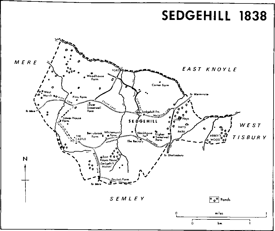
Sedgehill 1838
An estate held of Shaftesbury abbey, (fn. 58) possibly the later EAST HAYES HOUSE farm, (fn. 59) was settled in 1319 by John of Mere and his wife Eleanor on themselves and their daughter Margaret. (fn. 60) Margaret married Roger of Bisterne (fn. 61) and it is probable that after her death in 1349 her Sedgehill estate descended like one in Minstead (Hants) to her son John Bisterne (fn. 62) (fl. 1380), to that John's son John (fn. 63) (d. 1399), and to Elizabeth, daughter of John (d. 1399), who married Sir John Berkeley (fn. 64) (d. 1428). (fn. 65) It then apparently passed in the direct male line to Sir Maurice Berkeley (d. 1460), Sir Maurice Berkeley (fn. 66) (d. 1474), and William Berkeley (fn. 67) (d. s.p. 1485). (fn. 68) William's successor was his sister Catherine (d. 1494), who married John Stourton, Lord Stourton (d. 1485), and Sir John Brereton. Her estate passed successively to Brereton, (fn. 69) to her daughter Werburgh Brereton (d. 1525), who married secondly Sir William Compton (d. 1528), to Compton, to Peter Compton (d. 1544), the son of Werburgh and Sir William, (fn. 70) and to Peter's relict Anne. (fn. 71) On the death in 1588 of Anne, then the relict of William Herbert, earl of Pembroke, (fn. 72) the estate reverted to her son Henry Compton, Lord Compton (d. 1589), (fn. 73) whose son William, Lord Compton, sold it to Thomas Aubrey in 1591. (fn. 74) The estate may have descended like the manor of Charnage or Chaddenwick in Mere until 1690 or later. (fn. 75) Thomas Grove owned East Hayes House farm, 48 a., in 1826 (fn. 76) and it was part of the estate settled c. 1827 on his son George. (fn. 77) The estate included a house called Hall Place, which may have stood on the earthwork called the Castle, and a close called East Hayes in 1559. (fn. 78) A house, called Lower House in 1820, East Hayes House in 1826, Sedgehill Manor from c. 1897, was built on East Hayes close east of Butterstake Lane between 1811 and 1820. (fn. 79) It is a brick house of two storeys, the upper of which is tile hung, and was enlarged eastwards c. 1900. The interior was decorated c. 1900 in 17th- and 18th-century styles.
In 1558 Richard Audley sold BUTTERSTAKES farm, 42 a., to Ellen Parsons. (fn. 80) The farm was owned in 1574 by Thomas Parsons or Frowd (fn. 81) and descended to John Parsons or Frowd (d. c. 1602), to John's son Edward Parsons or Frowd (fn. 82) (d. 1637), and to Edward's son John Frowd (fn. 83) (will proved 1675). (fn. 84) John's son Edward (will proved 1715) (fn. 85) in 1707 sold the 50–a. farm to his son Edward (will proved 1744), who devised it to his adopted son James Frowd (fn. 86) (d. 1765). (fn. 87) James's son, the Revd. John Frowd (d. 1826), was the owner in 1780. (fn. 88) By 1826 James Bracher had acquired the farm, possibly by purchase from Frowd. (fn. 89) Butterstakes farm was merged before 1837 with Berrybrook and Whitemarsh farms. (fn. 90) It was sold with them by S. J. Young in 1931 to the Wiltshire county council, (fn. 91) who owned Butterstakes farm, 70 a., in 1984. (fn. 92)
WHITEMARSH farm was owned by Thomas Laws in 1780. (fn. 93) James Bracher owned that, BERRYBROOK farm, and Butterstakes farm in 1826, (fn. 94) a total of 162 a. in 1837. (fn. 95) His farms passed between 1867 and 1875 to Alfred Bracher (fn. 96) (d. 1884). From Alfred the farms passed to his brother Thomas (d. 1892), to Thomas's relict Elizabeth (d. 1914), and to Thomas's grandson J. T. B. Wadman. In 1919 Wadman sold them to S. J. Young, who in 1928 sold Berrybrook House and a little land to Mrs. E. H. H. Sutton. Young in 1931 sold Whitemarsh farm, 147 a. which included Butterstakes farm, to the Wiltshire county council, (fn. 97) the owner in 1984 of Berrybrook, earlier Whitemarsh, farm, 75 a. (fn. 98)
The farm called Goods (fn. 99) or LOWER SWEETWELL in the earlier 19th century, (fn. 100) Sweetwell in the 20th, was sold in 1574 by William Grove and Thomas Aubrey to John Parsons or Frowd and his wife Denise. (fn. 101) It descended, possibly like Butterstakes farm, to Edward Frowd (will proved 1715), who devised it to his wife Elizabeth and to his sons Thomas, James, and Blackborrow. (fn. 102) It belonged to members of the Still family in 1780 and 1827. (fn. 103) James Bracher owned it in 1837 (fn. 104) and 1850, Thomas Bracher c. 1877. (fn. 105) From Thomas, Lower Sweetwell, 143 a., passed in 1892 like Whitemarsh farm to his relict Elizabeth (d. 1914), whose executors held it in the years 1915–26. Mrs. M. E. Grant was the owner in 1927. (fn. 106) In 1984 Sweetwell farm, 77 a., belonged to Mr. R. Drake. (fn. 107)
Lands called Sweetwell, later HIGHER SWEETWELL, farm, were owned by members of the King family in the 17th century. (fn. 108) They were sold in 1674 by William and John King to John Frowd (fn. 109) (will proved 1675), who devised them to his son Thomas Frowd. (fn. 110) Edward Frowd (will proved 1715), Thomas's brother, devised Sweetwell House and 15 a. to his son Edward Frowd. (fn. 111) They descended like Butterstakes farm (fn. 112) to the Revd. John Frowd, from whom William Helyar (d. 1820) bought Higher Sweetwell farm before 1812. (fn. 113) The farm, 88 a. in 1837, (fn. 114) passed like Hays to Walter Shaw-Stewart, who owned the 116–a. farm in 1927. (fn. 115)
Richard Audley sold WOODHOUSE farm, 78 a., to William Goddard in 1561. Goddard assigned it in 1575 to his son Nicholas (fn. 116) (d. 1618), whose heir was his grandnephew Nicholas Goddard. (fn. 117) Nicholas (d. c. 1654) was succeeded by his sons Edward (d. 1666) and Nicholas (d. 1669). From the last Nicholas the farm passed to his son John (d. 1702) and to John's son John (d. s.p. 1715). The last John was succeeded by his sister Mary Goddard, who married William Helyar in 1717. (fn. 118) Helyar's estate in 1717 may have included, besides Woodhouse and Hays farms, land called PITTS farm. All three farms descended in the direct male line to William Helyar (d. 1841) who merged Woodhouse and Pitts farms c. 1827 as Pitts farm, 170 a. (fn. 119) W. H. Helyar sold the farm after 1850. (fn. 120) Like Hays, Pitts was probably bought by Richard Grosvenor, marquess of Westminster, and it descended to Walter Shaw-Stewart (fn. 121) (d. 1934), whose relict offered the farm for sale in 1936. (fn. 122) It was afterwards owned by George Mells, to whose daughter, Mrs. B. Ridout, it belonged in 1984. (fn. 123)
In 1562 Richard Audley sold HAYS farm, 38 a., to Richard Parsons. (fn. 124) Richard Parsons or Frowd, presumably another, sold the farm in 1590 to Thomas King. (fn. 125) From Thomas (d. 1596) Hays passed to his son Jasper (fn. 126) (d. 1609), and to Jasper's son Thomas, (fn. 127) who sold it in 1648 to John Tyse (fn. 128) (d. 1670). Tyse was succeeded by his relict Mary and daughter Mary, wife of Nicholas Goddard (fn. 129) (d. 1669) and afterwards of William Weston. (fn. 130) In 1693 Mary Weston settled Hays on her son John Goddard (fn. 131) (d. 1702), and it passed to John's son John (d. s.p. 1715) and daughter Mary Goddard, who in 1717 married William Helyar (d. 1723). (fn. 132) Hays descended to William and Mary's son William (fn. 133) (d. 1783), and to that William's son William (d. 1820). (fn. 134) In 1812 Helyar gave the estate to his son William (d. 1841), (fn. 135) whose son W. H. Helyar sold it after 1850. The purchaser was probably Richard Grosvenor, marquess of Westminster (d. 1869), whose relict Elizabeth sold her life interest in it between 1877 and 1880 to her son-in-law Sir Michael ShawStewart, Bt. (d. 1903). Sir Michael's son Walter offered the house and 58–a. park for sale in 1928. (fn. 136) In 1956 the house and 6 a. were bought by R. Coates, who sold them in 1963 to Mr. and Mrs. R. T. Emberson, the owners in 1984. The rest of the park was bought c. 1956 by Mr. M. Stiles, who built a farmhouse on it and in 1984 owned the farm. (fn. 137) Richard Parsons or Frowd built a house called Hays on the farm before 1584. (fn. 138) It, or a successor, may have been the house of that name which stood east of the Warminster—Shaftesbury road in 1773. (fn. 139) The house was rebuilt c. 1796 for William Helyar (fn. 140) (d. 1820) as a three-storeyed house of white brick with an east entrance front of three bays and north and south fronts of four bays. A two-storeyed stable block and service court were built west of it. In the later 19th century two-storeyed wings were built north of the house, then called Sedgehill House, (fn. 141) the stables and the service court were extended westwards, and a two-storeyed range of red brick was built on the west to link the house to the service building.
In 1657 Thomas Grove conveyed the land which became Sedgehill farm, renamed CHURCH farm before 1886, to his kinsman Hugh Grove (fn. 142) (d. 1658). The farm passed like Chisenbury Priory manor in Enford to Hugh's relict Anne, who assigned it to her brother-in-law John Grove (d. 1699). (fn. 143) It descended to John's son Hugh Grove (fn. 144) (d. s.p. 1765). (fn. 145) William Chafin Grove (d. s.p. 1793), Hugh's nephew, (fn. 146) was the owner in 1778 (fn. 147) and his trustees held the farm in 1805. (fn. 148) His nephew Chafin Grove was in possession in 1826, and in 1851 was succeeded by his cousin William Chafin Grove (d. 1859). (fn. 149) That William was succeeded in turn by his son William Chafin Grove (d. s.p. 1865) and daughter Julia Chafin Grove (d. 1891), from whom Church farm passed to her cousin G. T. Chafin Grove. (fn. 150) It passed after G. T. Chafin Grove's death in 1913 to his son E. G. Troyte-Bullock, (fn. 151) who sold it in 1920 to the tenant John Doggrell (d. 1920). The farm passed to Doggrell's relict Frances, whose mortgagees sold it in 1936 to the Wiltshire county council, (fn. 152) the owner in 1984.
Economic History.
In the 12th century Shaftesbury abbey had 1 hide of land, perhaps held in demesne, in Sedgehill. There were also 10 tenants, of whom 3 held 1 yardland each, 3 held ½ yardland each, and 4 held ¼ yardland each. The demesne was cultivated partly by labour services owed by the tenants. (fn. 153) In 1225 the abbey's 17 tenants all kept draught animals and a few cows and one also had a flock of 10 sheep: (fn. 154) they presumably fed them on common pastures including that to the south-east referred to in 1241. (fn. 155) The abbey's tenants at Sedgehill may still have held their lands for rent and customary works in the later 15th century and earlier 16th. (fn. 156) The demesne farm was held under lease in 1538 (fn. 157) and in 1565. (fn. 158)
Before 1558 there were 16 or more farms in Sedgehill: all except Hall Place, later East Hayes, farm, were copyholds or leaseholds of the manor. From 1558 the lords apparently sold 10 or more of the leasehold and copyhold farms. The common pastures were then in the north-west part of Sedgehill and in strips or lanes bordering the roads in other parts. A little over 212 a. of pasture were inclosed and apportioned among 11 farms c. 1574. (fn. 159) A few lanes were not inclosed and were open and apparently common in 1984.
In 1826 Sedgehill contained 19 farms, of which 12 measured 50 a. or less. Four farms, Pitts, Woodhouse, Butterstakes, and Higher Sweetwell, each consisted of between 50 a. and 100 a., and three farms, Sedgehill West, Sedgehill, later Church, and Goods, later Lower Sweetwell, each measured between 100 a. and 150 a. James Bracher worked three farms, Berrybrook, Butterstakes, and Westmarsh, a total of 109 a., as owner, and two, Corner and Sedgehill, later Church, a total of 190 a., as tenant. (fn. 160)
By 1837 Woodhouse and Pitts farms had been merged as Pitts farm, 170 a., Berrybrook, Whitemarsh, and possibly Butterstakes, farms as Berrybrook, 162 a., and Sedgehill West, East Hayes House, and perhaps a farm of 43 a., as Lower, or Lower House, farm, 219 a. In 1837 Sedgehill, later Church, and Lower Sweetwell farms also remained over 100 a., Higher Sweetwell and Corner farms were between 50 a. and 100 a., and there were seven farms of fewer than 50 a. William Bracher, who worked Westmarsh farm, 10 a., as owner, and Corner and Pitts farms, 219 a., as tenant, and George Grove, owner of Lower House farm, occupied the most land. Husbandry was predominantly pastoral. Sedgehill contained 670 a. of pasture in small fields, and 328 a. of arable, also in small fields. The farms with the highest proportion of arable were in the east: Sedgehill farm included 73 a., about two fifths of its total acreage, and Blackhouse farm contained 17 a., half its acreage. About a third of Pitts farm and a quarter of Lower House farm, both in the west part of Sedgehill, were arable. Crops were sown in a fivecourse rotation. There were 100 sheep and 187 cows in the parish. Sedgehill farm had a 2–a. milking barton, and there were dairies at Woodhouse Farm and Lower Farm. (fn. 161)
The amount of arable and the acreage over which clover and other grasses were grown in rotation gradually decreased after 1837 as more land was laid down to permanent meadow or pasture. In 1876 cereal and root crops were grown over less than a fifth of Sedgehill, and in 1916 there was no arable land. There were possibly fewer than 100 sheep in 1876 and there was none in 1906. Over 200 cows were kept in the later 19th century, over 160 c. 1916. Pigs were also reared until c. 1900 (fn. 162) and there was a firm of bacon curers, J. Walton & Co. Ltd., in Sedgehill in the later 19th century. (fn. 163)
The land was occupied by 10 or more dairy farms in the earlier 20th century, of which only two, Church and Berrybrook, were over 150 a. (fn. 164) Sedgehill contained 12 small farms in 1954. (fn. 165) In 1984 there were 10 dairy farms. The three farms into which Church farm was divided c. 1936, Berrybrook and Butterstakes, separate from c. 1931, Sweetwell, Lower House, and Hays each contained between 50 a. and 100 a. Only 5 a. of the 93 a. of Peake's farm were in Sedgehill, (fn. 166) and Pitts farm alone measured more than 100 a. (fn. 167)
Woodland in Sedgehill in 1582 was called Abbey's Wood. (fn. 168) Much of it was grubbed up and was pasture and meadow c. 1600. (fn. 169) Its remnant on the eastern boundary was still called Abbey's Wood in 1984. In 1629 there were 30 a. of woodland, (fn. 170) of which 12 a. were grubbed up and were pasture in 1713. (fn. 171) There were 23 a. of woodland in 1837, most on the higher ground in the south part of the parish. (fn. 172) The pattern of woodland, although not every copse, was the same in 1984.
Local Government.
From c. 1333 or earlier until the Dissolution manorial courts were held by Shaftesbury abbey. Until 1444 or later their proceedings were recorded with those of Tisbury manor courts and from 1472 or earlier with those of the manor courts of the barton of Shaftesbury. At the courts a reeve was appointed, trespasses, particularly in Abbey's Wood, and buildings in need of repair were presented, licences to marry were sold, and customary tenants were admitted and, in the earlier 15th century, licensed to have undertenants. A bondman's son was licensed in 1335 to take holy orders, as he was in Tisbury manor court. In the period 1364–93 several unfree tenants moved away from Sedgehill without the abbess of Shaftesbury's permission. One, Thomas Butterstake, was licensed in 1393 to live elsewhere provided that he kept the buildings on his customary holding in repair. In 1528 customary tenants were forbidden to pasture sheep in the marsh between 25 April and 1 November. (fn. 173) At courts in the period 1559–71 similar business was done and manorial customs were recited. In 1559 and 1568 tenants were presented for allowing pigs on the commons and in 1561 for allowing calves in the lord's coppices. The court in 1568 allotted to the tenants pasture rights on the wastes and commons and forbade them to pasture sheep there between 25 March and 1 November. (fn. 174)
From c. 1793 (fn. 175) the vestry appointed yearly a churchwarden, two overseers of the poor, and, until 1893, a way warden. (fn. 176) Yearly expenditure on the poor in the later 18th century and earlier 19th was among the lowest in the 11 parishes of Dunworth hundred, except in 1827 when Sedgehill spent the fifth highest sum. (fn. 177) Sedgehill's average yearly expenditure was £146 in the period 1833–5. The civil parish became part of Mere poor-law union in 1835. (fn. 178) It was included in Salisbury district in 1974. (fn. 179)
Church.
A church possibly at Sedgehill in the earlier 14th century (fn. 180) may have been served from Shaftesbury abbey, and inhabitants of Sedgehill were buried in the abbey churchyard. In 1395 a graveyard at Sedgehill was consecrated and the church was annexed as a chapel to the church of Berwick St. Leonard, of which the abbess of Shaftesbury was patron. (fn. 181) The advowson of Berwick passed at the Dissolution from the abbess to the Crown. Because the chapel of Sedgehill was not expressly mentioned when the Crown sold the advowson of Berwick in 1545, (fn. 182) it was later referred to as a royal free chapel. Its status as a chapel of Berwick was confirmed in 1569 and was unchallenged until 1585 when royal commissioners found it to be a royal free chapel. (fn. 183) In 1585 the Crown sold the church, a cottage, ½ a., and the tithes of Sedgehill to Anthony Collins. (fn. 184) Collins sold the property to James Powton, a son of the patron of Berwick. In 1590 James conveyed it to his son Constantine Powton (fn. 185) (d. c. 1600). In 1608 Constantine's brother Francis sold it in medieties to Nicholas Goddard and Richard Thomas. (fn. 186) Thomas sold his mediety in 1612 to Thomas Benett (fn. 187) and Goddard's passed in 1618 to his grandnephew Nicholas Goddard. (fn. 188) Neither mediety was afterwards mentioned. The advowson of the free chapel was not expressly reserved to the Crown in 1585, (fn. 189) and it is not clear how the church was served between then and 1619. The Crown presented rectors of Sedgehill, so called, in 1619 and 1622. (fn. 190) After 1661 Sedgehill was again a chapel of Berwick St. Leonard church. (fn. 191) In 1914 it was detached from Berwick, part of East Knoyle parish was added to it, and the ecclesiastical parish of Sedgehill was created. The benefice was a perpetual curacy but, under an Act of 1868, it was designated a vicarage and its incumbent was called a vicar. (fn. 192) The patronage was vested in the patron of Berwick St. Leonard, Lady Octavia Shaw-Stewart. It passed in 1921 to her son Walter Shaw—Stewart, who transferred it in 1927 to his son M. S. Shaw-Stewart (d. 1936). (fn. 193) The descent of the advowson in the period 1936–76 is not clear. It may have reverted, as the advowson of Fonthill Gifford did, to Shaw—Stewart's mother Mary Shaw-Stewart (d. 1943) and have passed to her grandson Mr. N. W. Rimington, both Roman Catholics. The benefice was held in plurality with the rectory of East Knoyle from 1952 when the bishop of Oxford, patron of East Knoyle, presented the rector of East Knoyle to it. The benefice was united in 1976 with the rectory of Semley and the patronage was vested in the patrons of Semley, the dean and chapter of Christ Church, Oxford. (fn. 194) In 1985 the rectory of East Knoyle was added to the united benefice and from 1985 the patronage was shared by the dean and chapter and the bishop of Salisbury, patron of East Knoyle. (fn. 195)
The rector of Berwick St. Leonard was entitled to all the tithes of Sedgehill, presumably from 1395. For tithes of milk, he took cheeses once a fortnight from May to November. (fn. 196) The tithes and modus were valued at £250 in 1837 and commuted. (fn. 197) The income was assigned to the vicar of Sedgehill in 1914. (fn. 198)
A cottage north of the church may have been occupied occasionally by chaplains from the later 16th century. (fn. 199) Before 1826 John Benett, the patron of Berwick St. Leonard, bought Keepings Farm, south of the church, and 12 a. to be leased to the incumbent as an inducement to him to live in Sedgehill. The house was called the Rectory until 1908. (fn. 200) Hill Cottages, nearer the church, were then made into a single house which was called the Rectory 1909–14, the Vicarage 1914–33. (fn. 201)
The rector may have served the church himself c. 1570 when he was involved, during a service, in an affray with the son of the patron. (fn. 202) From the later 16th century to the early 19th the church was usually served by chaplains. (fn. 203) The chaplain employed in 1588 taught 'sound doctrine'. (fn. 204) Another, George Swaine, signed the Concurrent Testimony in 1648. (fn. 205) There was no copy of Erasmus's Paraphrases in the church in 1585, (fn. 206) and in 1662 no Book of Homilies or copy of Jewell's Apology. The members of six Sedgehill families were excommunicated in 1666, perhaps because they were nonconformists, and in 1668 other parishioners, possibly also nonconformists, did not attend services. (fn. 207) In 1783 the chaplain, who lived at Shaftesbury, held a service on Sunday at Sedgehill but none on weekdays, and also took occasional services at Semley. Communion was celebrated four times a year and there were 20–30 communicants in Sedgehill. (fn. 208) The rectors lived at Sedgehill and usually served the church themselves from c. 1826 to 1914. (fn. 209) On Census Sunday 1851 there was a congregation of 60 in the morning and of 53 in the afternoon. (fn. 210) In 1864 the rector held Sunday morning and evening services at Sedgehill which were attended by an average congregation of 65: his curate served Berwick St. Leonard. The services held at Sedgehill on Ash Wednesday and Ascension day in 1864 were attended by 15 people and those held on Good Friday by 20 in the morning and 35 in the afternoon. An average of 23 communicants in Sedgehill received communion at Christmas, 29 at Easter, and 25 at Whitsun. Communion was celebrated additionally every six weeks and was received by an average of 24 people. (fn. 211)
The church was dedicated to ST. CATHERINE in 1395. (fn. 212) It is of ashlar and consists of a chancel, a nave with north vestry and south porch, and a west tower. The style of its east window in 1804 suggests that the church stood in the earlier 14th century, when it may have consisted of a chancel and a nave with south porch. The tower was built in the early 16th century. New windows were inserted in the south chancel wall and north and south nave walls, and the upper stages of the tower were rebuilt, in the 17th century. (fn. 213) The porch was rebuilt in 1765. (fn. 214) The chancel and nave were rebuilt, and the vestry added, in an early 14th-century style in 1845. (fn. 215) A. cross stood east of the church in 1804 (fn. 216) and north of it c. 1908 (fn. 217) and in 1984. The shaft, made in the 14th century, stands on a base perhaps of the same date. The cross itself was renewed in the 19th century.
In 1553 royal commissioners took 2½ oz. of plate and left a chalice for parish use. It did not survive in 1891. A new communion set was given in 1856. (fn. 218) That, and a paten given in 1918, were used in 1984. (fn. 219) There were three bells in 1553. John Lott recast the tenor in 1667, another John Lott the second bell in 1671, and William Cockey the treble in 1748. New treble and second bells, both cast by John Warner & Sons in 1892, were added to make the peal of five (fn. 220) which hung in the tower in 1984. (fn. 221) Registrations of marriages survive from 1755, those of baptisms from 1759, and those of burials from 1763. (fn. 222)
Nonconformity.
The parishioners who were excommunicated in 1666 and those who did not attend church in 1668 (fn. 223) were possibly nonconformists. Of the 28 dissenters in the parish of Berwick St. Leonard in 1676, (fn. 224) most may have lived at Sedgehill. The meeting for which Edward Frowd's house at Sedgehill was certified in 1700 was connected with a Baptist congregation at East Knoyle led by John Williams. (fn. 225) In 1864 members of four Sedgehill families were said to be Baptists but to have no meeting house. (fn. 226)
Education.
In 1808 the parish clerk of Sedgehill kept a school (fn. 227) which had lapsed by 1818. (fn. 228) Another school was opened in 1825, (fn. 229) and in 1826 a schoolroom and a cottage for the schoolmistress were built. (fn. 230) That school was attended by 30–45 children in 1833. (fn. 231) A 'motherly woman of humble attainments' taught 15–20 children in it in 1858. (fn. 232) A new school replaced it in 1872. (fn. 233) The average number attending declined from 35 in 1907–8 to 18 in 1921–2. The school was closed in 1922 (fn. 234) and was afterwards a parish room. (fn. 235) From 1922 Sedgehill children attended school at Semley. (fn. 236)
Charity for the Poor.
Julia Chafin Grove (d. 1891) bequeathed £100 for a clothing club in Sedgehill or for clothing or coal for the poor. The income, £2 11s. yearly, was spent c. 1906 on 4½ yd. of flannel each for 10 people in Sedgehill. (fn. 237) In 1984 no distribution of the £2 yearly income had been made since 1975. (fn. 238)