A History of the County of Wiltshire: Volume 18. Originally published by Boydell & Brewer for Victoria County History, Woodbridge, 2011.
This free content was digitised by double rekeying. All rights reserved.
'Cricklade - Introduction', in A History of the County of Wiltshire: Volume 18, ed. Virginia Bainbridge (Woodbridge, 2011), British History Online https://www.british-history.ac.uk/vch/wilts/vol18/13-20 [accessed 30 April 2025].
'Cricklade - Introduction', in A History of the County of Wiltshire: Volume 18. Edited by Virginia Bainbridge (Woodbridge, 2011), British History Online, accessed April 30, 2025, https://www.british-history.ac.uk/vch/wilts/vol18/13-20.
"Cricklade - Introduction". A History of the County of Wiltshire: Volume 18. Ed. Virginia Bainbridge (Woodbridge, 2011), British History Online. Web. 30 April 2025. https://www.british-history.ac.uk/vch/wilts/vol18/13-20.
In this section
CRICKLADE
CRICKLADE is a small town on the upper Thames, 10 km. north-west of the centre of Swindon and 11 km. south-east of Cirencester (Glos.). (fn. 1) It was probably planned, built, and fortified c. 880 and became the site of two parish churches, St Sampson's and St Mary's, whose parishes were united in 1899. This chapter is divided into three articles, Ancient Parishes, Cricklade Borough, and Outer Cricklade. It deals with both ancient parishes: St Sampson's covered half the town and all the surrounding land and included a large part of Braydon forest and the villages of Chelworth, Calcutt and Widhill; St Mary's included little more than the other half of the town. Aspects of Cricklade's history which concerned the town and its combined parish as a whole are treated in the first article. Urban Cricklade is the concern of the second article. Finally the manorial, economic and settlement history of outer or rural Cricklade are described in the third article.
ANCIENT PARISHES
The territory that later comprised the two Cricklade parishes may have existed as a landholding in 688, when 100 cassati east of Braydon was acquired by an exchange of land from Aldhelm by Baldred, a client king or subregulus of the West Saxon kingdom with dominion in northern Wessex. (fn. 2) The initial headquarters or caput of this landholding was probably at Chelworth, and the focus of settlement only moved to the site of present Cricklade when a fortified town was established there c. 880. (fn. 3)
There was a church at Cricklade in the later 10th century, and St Sampson's was built then or in the 11th century. It stands on an unlikely site for a church built as part of a new town, off the line of the main street. The site would have been convenient for a church serving the early farmsteads of Chelworth, and a church may have been built there before the town was planted. In the 11th century the parish of St Sampson's presumably included the town, Chelworth, Calcutt, and Widhill.
St Mary's church was built in the early 12th century, probably as a daughter church of St Sampson's, but part of St Sampson's parish was later assigned to St Mary's, probably in the later half of the 13th century. St Mary's parish, just 122 a. (49 ha.) in area, comprised the north end of the town and some land either side. (fn. 4) In the Middle Ages there was apparently a chapel at Widhill which was served by the vicar of St Sampson's and in which the inhabitants of Widhill had all rights except burial.
Cricklade, in common with other Wiltshire boroughs, was not assessed in hides in 1086, but paid 'the third penny', a mark of its urban status. (fn. 5) Many estates in north-east Wiltshire in 1086 possessed burgages in Cricklade, possibly an indication that they had contributed to its fortification and benefited from its protection under the Alfredian defensive system. (fn. 6) In addition four Domesday estates within the parish of St Sampson's, Cricklade, were assessed in 1086: Calcutt and two estates at Widhill, each at 5 hides; and Chelworth at 2 hides. Chelworth's low assessment probably reflected the disruption caused by the creation of a town within its territory. St Sampson's church itself was assessed for the third penny. (fn. 7)
Before the conquest uncleared and sparsely-settled woodland stretching 7 km. south-west of Chelworth may have belonged to the king or his thegns as lords of Chelworth, and afterwards the kings assumed the right to hunt in it. The woodland was part of the royal forest of Braydon by the 13th century, (fn. 8) when it may already have been divided into separate parishes. It came to be called Peverell's wood, Keynes' rag, and Poucher's rag, (fn. 9) having apparently been divided between coheirs Hugh Peverell and Adam of Purton, whose descendants included Robert Keynes (d. by 1281) and John Poucher (d. 1405). In the early 14th century Peverell's wood passed to the Crown, which held Cricklade and Little Chelworth manors, (fn. 10) and in the 17th century it was part of St Sampson's parish. (fn. 11) Keynes rag and Poucher's rag were part of Purton parish and in 1637 the vicar of Purton successfully resisted a claim by the vicar of St Sampson's that they lay in St Sampson's parish; the two rags extended westwards as a tongue through much of Peverell's wood, (fn. 12) and the south-west part of St Sampson's parish, wrapped around them in a U-shape.
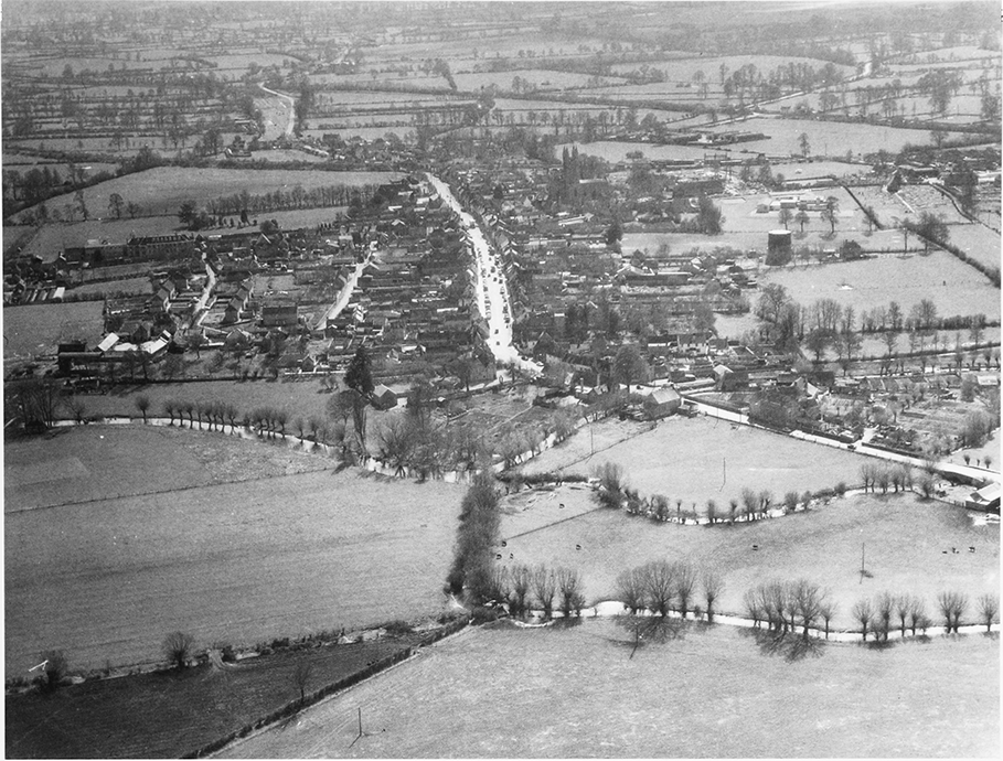
MAP 4. Parishes of St Sampson and St Mary c. 1890. Outline map showing the full extent of the ancient parishes of Cricklade and pattern of settlement. See separate maps for more detail.
St Sampson's parish, 6,289 a. (2,545 ha.), and St Mary's parish were united in 1899 as Cricklade parish, 6,411 a. (2,594 ha.). In 1934 Widhill was transferred to Blunsdon St Andrew, and Cricklade parish was thus reduced to 5,724 a. (2,316 ha.). (fn. 13) In 1984 the U-shaped south-western part was transferred to adjacent parishes, the north part to Leigh, the south to Purton, and the west to Minety. A small part of Latton parish was transferred to Cricklade, leaving the parish 1,548 ha. (3,825 a.). (fn. 14)
Boundaries
Watercourses formed most of the parish boundaries. The Thames was the northern boundary of St Sampson's and, after it was formed, of St Mary's. It marked the boundary between Cricklade and South Cerney (Glos.) c. 999. (fn. 15) In two places, north-east and north-west of the town, the boundary left the Thames and followed minor watercourses; it is likely that the Thames was diverted, to the west to serve the town and to the east to facilitate navigation, and that the boundary followed its original course. (fn. 16) About 1802 c. 150 m. of the watercourse marking St Sampson's boundary with Latton north-west of the town was straightened and the parish boundary moved to the new course. (fn. 17) South-east of that diversion c. 500 m. of the same watercourse, and with it the boundary between St Mary's and Latton, was straightened between 1840 and 1875. (fn. 18) In 1984 the boundary with Latton was moved from the watercourses to a new stretch of main road built in 1975 on the line of the Roman road. (fn. 19) East of the town both the Thames and its north-south tributary, the Ray, were followed by the boundary with Eisey; west of the town the boundary with Leigh followed another north-south tributary of the Thames, and the boundary of much of the southwest of the parish followed Derry brook, a head stream of the Thames. For short distances south of the town the boundary with Purton followed the Key.
Roads and lanes also marked portions of the parish boundary. South-east of the town Widhill's boundary with Eisey and Broad Blunsdon followed the Roman road. On the U-shaped south-western part of St Sampson's parish the Cricklade–Malmesbury road marked the north boundary of the northern arm of the U, and lanes marked parts of the north and south boundaries of the southern arm and the west end of the parish. (fn. 20)
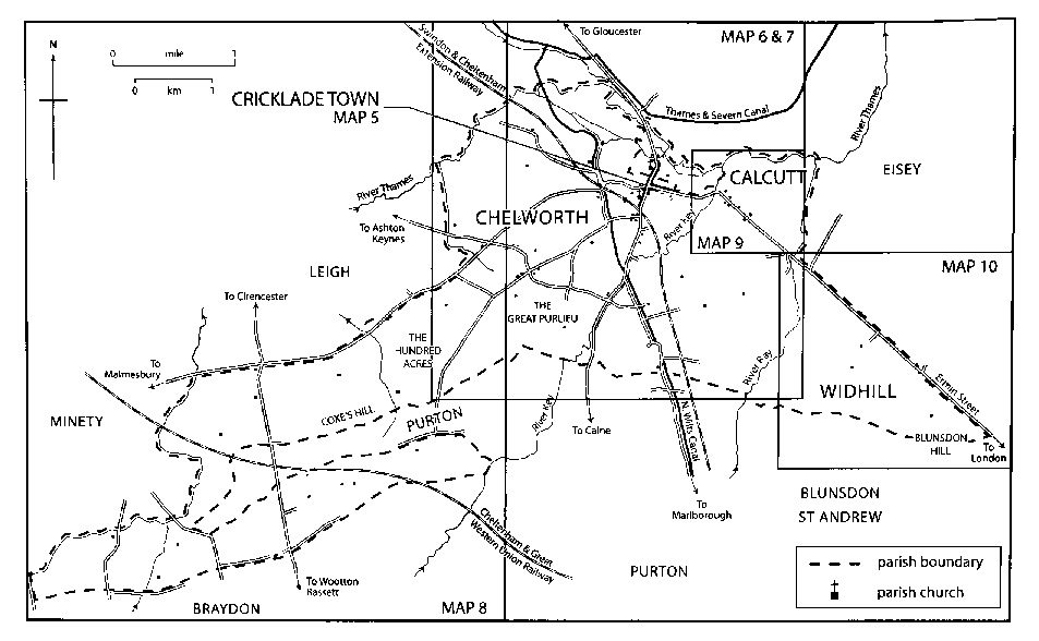
1. Aerial view of Cricklade, looking south in 1963, showing the high street along which Anglo-Saxon settlement was planted. The street crosses the Thames near St Mary's Church, and follows a causeway north towards Ermin Street. The parish church of St Sampson forms a distinctive landmark to the south-west.
St Sampson's southern boundary with Purton was recorded in 1733: it was fairly straight and marked by no prominent feature besides the Key and the lanes on the southern arm of the U. (fn. 21) Likewise, Widhill's eastern boundary with Blunsdon St Andrew was marked by no prominent features. (fn. 22) Of the southern boundaries, only that part of the Purton boundary south of the town remained a boundary of Cricklade after changes to the parish in 1934 and 1984.
The boundary between St Sampson's parish and St Mary's is recorded in the early 19th century: north of the town it followed the Thames and what apparently was an old course of the Thames; east of the town it followed the Key. At High Street it ran through the garden and the passage of a house on the east side. The boundary between Widhill and the rest of St Sampson's parish, from 1934 between Cricklade and Blunsdon St Andrew parishes, was the Ray. (fn. 23)
Landscape
This section describes the parish as it was from c. 1899 to 1934. Oxford Clay covers nearly all of it, except on Blunsdon Hill where there are outcrops of Upper Corallian coral-rag and Lower Corallian silt and sand. The rivers and streams have deposited gravel and alluvium, epecially north of the town. There are deposits of gravel on high land at Chelworth and of glacial drift south of the town and at the west end of the parish. (fn. 24)
The parish drains south-north to the Thames, the original course of which was probably the parish boundary and which now crosses the northern tip of the parish. The Ray to the east, the Key in the centre, Derry brook to the west and two smaller streams west of the town, all flow to the Thames roughly from south to north. Blunsdon hill, at the east end of the parish, is the highest point at 145 m. and the land reaches 134 m. in the west. The lowest point is where the Thames leaves the boundary c. 80 m. east of the town. The valleys are shallow and, apart from the face of Blunsdon hill, there are few steep slopes in the parish. In the east between the Key and Blunsdon hill the land is nearly flat; west of the Key the ridges are sharper and reach over 90 m. in several places. South-west of Chelworth there is an extensive plateau at c. 90 m.
The clay and alluvial soils favour pastoral rather than arable farming. There were extensive meadows beside the Thames and the Ray, and most of Chelworth's land west of the Key was pasture. On flat land between the Ray and the Key both Calcutt and Chelworth had open fields. From the Middle Ages parts of the fields were used as meadow land and from the 17th century small areas were inclosed piecemeal as pasture. In the south-west of the parish woodland and woody ground was cleared in the mid 17th century, mostly for use as pasture. Nearly all the parish was grassland in 1936, (fn. 25) and in 2003. From 1943 to 1947 the plateau south-west of Chelworth was used by the RAF as an airfield. Nature reserves were created from meadow north-west of the town in 1973, from woodland at the south-west end of the parish in 1987, and from the former airfield in 2000.
Braydon Forest
Braydon forest, called Braydon wood in the seventh century, (fn. 26) encompassed an area of c. 50 square km. with the settlements of Charlton, Chelworth, Minety and Brinkworth near its borders. Anglo-Saxon and Norman kings, who held both Cricklade and Chelworth, may have hunted in the forest, which was subject to forest law by 1135. (fn. 27) Approximately one-third of the forest, at its greatest extent, lay within the Cricklade parishes. (fn. 28)
The boundary of the area subject to forest law was defined and altered several times. In 1225 it followed the Thames and the Key and contained Cricklade, the western half of Chelworth, and the south-west part of St Sampson's parish. In 1228, following the Thames and the Ray, it extended far beyond that sparsely populated woodland of c. 50 square km. and contained the whole of what was Cricklade parish from 1899 to 1934 except Widhill. In 1330 a new boundary, later called the Inner boundary of the forest, greatly reduced the area under forest law; (fn. 29) much of what lay between the two boundaries came to be called the purlieus of the forest. (fn. 30)
From 1330 the town and Calcutt lay outside Braydon forest and as before, the U-shaped south-western part of St Sampson's parish lay within it. The new boundary followed the Thames as far east as a mill west of the town, probably West mill. From the mill it ran across country to the west end of Purton Stoke village in Purton. Some of the landmarks named in 1300 on the boundary between the Thames and Purton Stoke cannot now be identified. The 1330 boundary was redefined and confirmed in the early 17th century and partially plotted on a map of c. 1800: it ran east from West mill, south along the west line of the town's fortifications to the Forty, south-west along Chelworth Lane (later Chelworth Road) to Lower Chelworth Green and thence along Braydon Lane, and south by field boundaries to Purton Stoke. The north-west part of Chelworth lay within the forest, and the lands which were or became Broadleaze, Chelworth, and Whitehall farms and the land east of the Cricklade–Purton road lay outside. (fn. 31) In Cricklade St Sampson parish the forest included farmsteads and farmland at Chelworth and woodland and woody ground south-west of it, little or none of which seems to have been the king's demesne in 1300. Much of the woodland and woody ground in St Sampson's and Purton parishes and within the Inner boundary passed to the Crown in the 14th century or later. (fn. 32)
In 1627 the Crown appointed commissioners to survey Braydon forest and in 1630 a decree of the court of Exchequer disafforested the area within the boundary of 1330. Thereafter the Crown leased the area to tenants, who began the process of inclosing the woodland and waste and gradually converted large tracts to farmland. (fn. 33)
Communications
Roads
The line of Ermin Street, the Roman road
from London via Silchester (Hants.) and Speen (Berks.)
to Cirencester and Gloucester, passes through both St
Sampson's and St Mary's parishes. (fn. 34) Excavations during
1954 and 1955 confirmed that it maintained its straight
course to cross an old course of the Thames north-east
of the town on an embankment, and continued in use
until c. 400. (fn. 35) The crossing fell out of use thereafter and
was replaced by another, north of the town, from which
Cricklade derives its name (possibly denoting a rivercrossing where bullaces grow), (fn. 36) and was continued
northward by a causeway, to rejoin the line of Ermin
Street near Weavers Bridge.
In the early Anglo-Saxon period a straight road to Malmesbury probably diverged from Ermin Street at what is now the north-west end of Calcutt village. (fn. 37) About 880 Cricklade was planted as a street across the Malmesbury road, which crossed the town's fortifications. Between its crossing with the street and an east gate in the fortifications the Malmesbury road came to be called Calcutt Street; west of the crossing it became Bath Road. From here, the road curved around the boundaries of the early assarts of Chelworth, and then ran south-west along the boundary of St Sampson's parish. (fn. 38) A road taking traffic to Purton and Wootton Bassett diverged from the Malmesbury road about 600 m. west of Ermin Street, at what is now called Spital Lane. (fn. 39) After Cricklade was planted, London–Gloucester travellers using Ermin Street passed through the town along Calcutt Street and High Street; beyond the north gate a bridge was built over the Thames, and the causeway carried traffic back to the line of the Roman road. Traffic from Gloucester and Cirencester to Wootton Bassett and Marlborough also passed along the main street. The roads to Wootton Bassett and Marlborough diverged c. 1 km. south of the town; the road to Marlborough, which ran through Lydiard Millicent parish and across downland, may have declined in importance from the 1760s.
In 1756 the Cricklade–Malmesbury road, Ermin Street between Cricklade and Blunsdon St Andrew, and a road from Blunsdon St Andrew to Swindon were turnpiked, and in 1758 Ermin Street was turnpiked from Cricklade to Cirencester. When, in 1791, the road leading south from Cricklade to Purton was turnpiked as part of a road to Wootton Bassett and Calne, each of the main roads serving the town had been turnpiked. The roads turnpiked in 1756 were disturnpiked in 1876, the Cirencester and Purton roads in 1879. (fn. 40) In 1946 the London–Gloucester road through the town was designated part of a trunk road to Hereford; (fn. 41) in 1975 a new dual-carriageway road near the line of Ermin Street enabled traffic to bypass the town. (fn. 42) The trunk road was given a second carriageway across the rest of the parish to the south-east in 1987, (fn. 43) and to the northwest in 1997. It is heavily used by traffic between Gloucestershire and the M4 motorway, with which it intersects south-east of Swindon. In 1970 a new road was built along the line of the disused railway immediately south-west of the town; (fn. 44) Bath Road was closed to through traffic, and the new road became part of the Malmesbury road.
West of the town several lanes which ran between the curved boundaries of Chelworth's early assarts survived in 2003. They include Blind Lane, an unmade road running north-south, and Stones Lane and the lane which links Upper Chelworth Green, Lower Chelworth Green, and Broadleaze Farm, both of which run roughly north-west and south-east. (fn. 45) Apparently at inclosure in 1816–17 a new straight road was made across the Malmesbury road and former common pasture to link Upper Chelworth Green and Ashton Keynes. (fn. 46)
Further south-west there was apparently no road across Braydon forest c. 1630, when the king's demesne in the forest was inclosed. (fn. 47) 150 a. was assigned for roads in St Sampson's and Purton parishes; the assignment was so large because the ground was considered spongy and deep in winter. In the 1630s there was dispute over how much land was needed for particular roads, (fn. 48) and apparently few new roads were made in St Sampson's. An east–west road called London Way was made between Minety and Purton Stoke, but may never have been well used. It survives as a bridleway and, in Purton parish, as Stoke Common Lane. Chelworth Lane (later called Chelworth Road), which leads from Cricklade to Lower Chelworth Green, was extended southwestwards to join it. The extension, called Braydon Lane in the 20th century, was closed in 1943 when the airfield was built. Near the south-west end of the parish a north–south Minety–Brinkworth road, and a road leading south-east and south from Minety, were probably made in the 1630s. (fn. 49) In 1810 a road from Cirencester to Wootton Bassett via Ashton Keynes was turnpiked; a new straight section of it was made across the south-west part of St Sampson's parish. The road was disturnpiked in 1864. (fn. 50)
River
The Thames was for long navigable to
Cricklade, but the suggestion that a settlement on the
site of the town was a river port serving Cirencester in
the Roman period seems to exaggerate the river's
potential for reliable navigation, especially upstream
from the Ermin Street crossing. (fn. 51) It was possible to row
from Bablake (Oxon.) to Cricklade in a single day in
summer 1641, (fn. 52) and boats and barges were apparently
using the river as far as Cricklade in 1677, when the
town asked parliament to prevent passage being
levied on those which passed St John's bridge at
Lechlade (Glos.). (fn. 53) In 1680 lead for the roof of St
Sampson's church was brought by boat, (fn. 54) and in the
18th century boats carrying six tons or more could
reach Cricklade. There was a pool on the south side of
the river immediately below the town bridge where
boats were presumably loaded and unloaded, but
there is no evidence that a wharf was built.
Commercial traffic on the upper Thames probably
ceased in or soon after 1789, the year in which the
Thames & Severn canal was opened. (fn. 55)
Canals
Proposals to connect the Thames and
Bristol Avon by canal upstream from Cricklade (and
so link London and Bristol) were put forward c. 1626
and later, but not implemented. (fn. 56) The Thames &
Severn canal which, with the Stroudwater canal,
linked the Thames at Inglesham to the river Severn
was opened in 1789. Without crossing either parish it
served Cricklade from Cricklade wharf in Latton
parish, and until 1810 it was the only London–Bristol
waterway. The wharf was probably used to distribute
coal mined in the Forest of Dean and Staffordshire. (fn. 57)
The canal was abandoned in 1927. (fn. 58)
The North Wilts. canal was opened in 1819; it linked London to the Severn, using the Thames & Severn and Wilts. & Berks. canals, by-passing the upper Thames. It crossed St Sampson's parish, by viaduct over the Thames and through a tunnel west of the town. Chelworth wharf was built south-west of the town. In 1821 the North Wilts. canal was vested in the Wilts. & Berks. Canal Company. (fn. 59) Traffic on both canals ceased in 1906 and they were closed in 1914.
Railways
A line built by the Cheltenham & Great
Western Union Railway across the south-west part of
St Sampson's parish was opened in 1841 and
transferred to the GWR in 1844. The line, via Swindon,
Cirencester, and, from 1845, Cheltenham was part of
the main route from London to south and west Wales
from 1850 to 1903. The nearest stations were at Minety
and Purton. (fn. 60) The line, but not the stations, remained
open in 2003.
The Swindon & Cheltenham Extension Railway linking Cirencester and Swindon was opened across St Sampson's parish in 1883. A station was built immediately south-west of the town. In 1884 the railway was merged with the Swindon, Marlborough & Andover Railway as the Midland & South Western Junction Railway, and from 1891 it linked Cheltenham and Southampton; it was absorbed by the GWR in 1923. (fn. 61) Through Cricklade it was built as a single line and never doubled. There were four sidings at Cricklade station, which had platforms for loading cattle and milk onto the trains. The station was closed to passengers in 1961, and shut entirely in 1963. (fn. 62)
Population
In 1377 Cricklade, Chelworth, Calcutt, and Widhill had 321 poll-tax payers. (fn. 63) In 1676 there were c. 500 people aged 16 and over living in St Sampson's parish and 140 in St Mary's. (fn. 64)
The population of the two parishes in 1801 was 1,330, which increased until the mid 19th century and decreased thereafter, and was at 1,399 little different in 1931. There were 1,556 inhabitants in 1811, 2,128 in 1841 when labourers building a railway were included, and 1,906 in 1851. By 1881 the population had fallen to 1,600, and 1,517 people lived in the united parish in 1901. The population of Widhill in 1934, when it was transferred to Blunsdon St Andrew, was c. 20. (fn. 65)
Cricklade's population increased in and after the Second World War. A camp built at Chelworth for RAF Blakehill Farm in the early 1940s was used by civilians until 1956, and in 1951 the population was 1,881. (fn. 66) New houses were built in the 1960s and 1970s and the population rose from 1,945 in 1961 to 2,431 in 1971 and 3,856 in 1981; from 1971 to 1981 the increase was c. 60 per cent. The population of the town continued to grow after 1981; although the parish was much smaller from 1984 it had 4,099 inhabitants in 1991 and 4,132 in 2001. (fn. 67)
SETTLEMENT
Early Settlement
No significant evidence for prehistoric settlement or activity has so far been discovered in the vicinity of Cricklade town, nor in the rural parish. Abundant Romano-British material of the 1st–4th centuries A.D., including pottery, coins and tiles, has been recovered from the town, especially the north and west sectors, both as stray finds and by excavation. (fn. 68) Possible Roman buildings near St Mary's church, and beneath the south-east corner of the rampart; Roman boundary or drainage ditches west of the High Street; and up to ten house platforms associated with Roman building material in the north-west corner of the town, have all been explored archaeologically. (fn. 69) There was a late Roman villa incorporating a channelled hypocaust heating system at Kingshill farm, east of Cricklade, (fn. 70) and a nearby (and probably associated) settlement site has yielded material of Roman and early to mid Anglo-Saxon date. (fn. 71) Three inhumations excavated outside the town's western defences in 1952 may not be evidence for a Roman cemetery, as claimed, but of much later date. (fn. 72) Despite the profusion of archaeological finds it is unlikely that any Roman settlement at Cricklade was urban in character, or (apart from Kingshill farm) that it continued into the Anglo-Saxon period, or that the later Anglo-Saxon town plan is derived from a Roman antecedent.
Aside from any residual activity at Kingshill farm, the earliest Anglo-Saxon settlement was apparently at Chelworth. Around 16 farmsteads were built, each on an assart which had been newly inclosed in an area roughly bounded by the Thames to the north, a tributary of the Thames to the west and south-west, and the Key to the east. Land between the assarts, to the east between the Key and the Ray, and beside the rivers was probably used in common as meadows and pasture by the occupants of the farmsteads, and it was probably on lands such as these that both Cricklade and Calcutt were planted as new settlements. (fn. 73) Widhill, east of the Ray, is also likely to have been an AngloSaxon settlement. South-west of Chelworth there was almost certainly no clearance of woodland, and no settlement, in the Anglo-Saxon period.
Settlement after c. 880
The establishment of a fortified town c. 880, probably on one of Chelworth's agricultural assarts, imposed a compact, regular and densely-packed urban community on a small area of the territory which Cricklade's parishes embraced, whilst the remainder developed as rural settlements with an arable and wood pasture economy akin to their forest-edge and Thames valley neighbours. The growth and development of urban Cricklade, and the settlement history of outer Cricklade, followed very different courses, therefore, and are given separate treatment in the ensuing articles.