A History of the County of Sussex: Volume 6 Part 3, Bramber Rape (North-Eastern Part) Including Crawley New Town. Originally published by Victoria County History, London, 1987.
This free content was digitised by double rekeying. All rights reserved.
'Lower Beeding', in A History of the County of Sussex: Volume 6 Part 3, Bramber Rape (North-Eastern Part) Including Crawley New Town, (London, 1987) pp. 7-12. British History Online https://www.british-history.ac.uk/vch/sussex/vol6/pt3/pp7-12 [accessed 28 April 2024]
LOWER BEEDING
THE modern parish of Lower Beeding, (fn. 1) which includes most of the area of the former St. Leonard's Forest, lies east of Horsham; it is 7 miles (11.3 km.) long from north to south and just over 3 miles (4.8 km.) wide at its widest point. In the Middle Ages Lower Beeding formed a single parish with Upper Beeding c. 11 miles (17.7 km.) to the south; the link between the two places was not tenurial, since Beeding manor in Upper Beeding seems never to have had tenements in Lower Beeding, but arose apparently because the tithes of St. Leonard's Forest were granted to Sele priory in Upper Beeding. (fn. 2) The Wealden part of the parish was called Nether Beeding in 1279 (fn. 3) and Lower Beeding apparently by 1646; (fn. 4) in 1793 it was alternatively called North Beeding. (fn. 5) At other times residents of the area were described as of St. Leonard's Forest. (fn. 6) Usually, however, before the 19th century the combined parish was referred to simply as Beeding, or Sele, parish. (fn. 7)
Lower Beeding was separate from Upper Beeding for poor-law purposes by the mid 17th century, and was included in Horsham union in 1835. (fn. 8) For ecclesiastical purposes it remained part of Upper Beeding until 1838, when most of it became a new ecclesiastical parish called Lower Beeding; Bewbush tithing, however, the northern part of the modern parish, remained part of Upper Beeding ecclesiastical parish until 1871, when it was included in the new Colgate ecclesiastical parish. (fn. 9) The description of Bewbush as a detached part of Upper Beeding civil parish in the 1870s and 80s (fn. 10) is therefore an error: Bewbush was not included in the area of Upper Beeding whose bounds were to be trodden in 1856, and the mid 19th-century records of the Upper Beeding parish officers never allude to it. (fn. 11) In 1891 Lower Beeding contained 10,153 a. In 1933 the south portion of a detached part of Crawley parish, comprising 421 a., was added to it, and in 1956 the rest of that part, comprising 136 a., was added too. At the latter date, however, 24 a. in the north-east of Lower Beeding, straddling the Horsham-Crawley road, were added to Crawley. In 1971, therefore, Lower Beeding contained 4,324 ha. (10,686 a.). (fn. 12) Land was exchanged in 1972 between Lower Beeding and Nuthurst parishes, Lower Beeding receiving Newells farm, and Nuthurst Old Park farm and other land. The parish had 4,230 ha. (10,452 a.) in 1981. (fn. 13)
The present article treats the history of Lower Beeding parish as it existed in the late 19th century. The boundaries of the late 19th-century parish are related to those of St. Leonard's Forest, and are discussed below. (fn. 14)
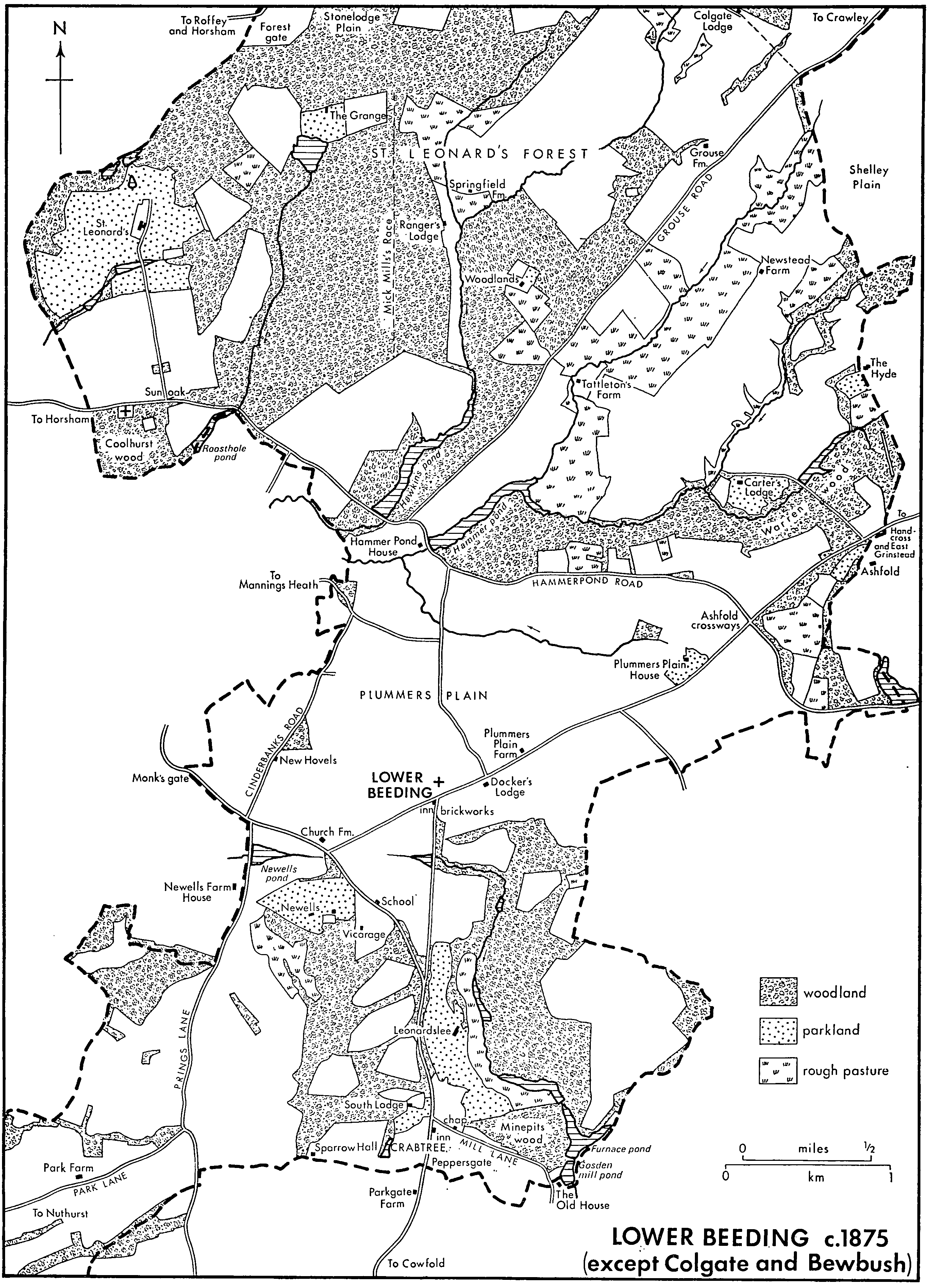
Geologically, Lower Beeding lies at the point where the High Weald of eastern Sussex merges into the Low Weald of the north-west part of the county. Most of the late 19th-century parish lies on the Tunbridge Wells sandstone of the High Weald, which also contains some clay. Portions of the northern and south-western parts of the parish, however, lie on the Weald clay of the Low Weald which is diversified in both places by outcrops of Horsham stone, and in the north also by Pleistocene and later river gravels, which for instance provided the site of Bewbush Manor House. (fn. 15)
Most of the parish lies above the 250-ft. contour, but there are abrupt variations in relief. The highest land is at Colgate (480 ft.), where a beacon erected in the Napoleonic War (fn. 16) was succeeded by a stone ornamental tower c. 105 ft. high; built between 1855 and 1857 of stone from nearby quarries, it was later open to the public, (fn. 17) but was demolished in 1945. (fn. 18) The modern village of Lower Beeding further south lies at c. 330 ft. above sea level, and land near the northern boundary of the parish reaches 350 ft. The northern part drains north-eastwards to the river Mole; the tributary stream through Bewbush tithing runs in a shallow valley which is followed by the Horsham-Crawley road and railway line. In the 16th century it was dammed to form a hammerpond for a furnace at Bewbush, later drained. (fn. 19) South of the watershed formed by the east-west ridge at Colgate rise springs which flow west to form the upper Arun; two were also dammed in the 16th century to form Hawkins and Hammer ponds, (fn. 20) while another follows a valley through the area formerly of open heathland called Plummers Plain. Further south again streams drain south or west to join the Adur, forming ponds near Newells Farm House and at Leonardslee; Furnace pond near Leonardslee was another hammerpond. (fn. 21)
Two east-west roads which wholly or partly follow prominent ridges seem to be ancient routes. The more northerly, through Colgate, was part of a route from Horsham to Ashdown Forest, (fn. 22) and passes the sites of two prehistoric barrows in Lower Beeding parish. (fn. 23) It certainly existed in 1650, (fn. 24) and was known in part in 1982 as Black Hill. The other road, from Horsham to Slaugham, passes close to Money mound, a Neolithic and Iron Age site which retained a religious function in Roman times. (fn. 25) That road too was used in the early 18th century, (fn. 26) and evidently also in the late 16th, since its present course runs along the dams of Hawkins and Hammer ponds and therefore provided the chief means of access to the ironworks there. (fn. 27) Part of the road was called Hammer Hill in the 1870s; in 1981 it was called Hammerpond Road. It is not clear which of the two roads was the road from Horsham to St. Leonard's Forest or St. Leonard's chapel mentioned in 1362 and later. (fn. 28) A third east-west route in the late 18th century led from Faygate on the north-west edge of the parish, south of Holmbush house, and then by way of Bewbush Manor House and Buckswood Farm (in Ifield) to Crawley. (fn. 29) In the early 18th century a branch road from Colgate to Holmbush linked it with the first road described above, to form one of two roads between Horsham and Crawley. (fn. 30)
Lower Beeding c.1875
(except Colgate and Bewbush)
The east-west road through Colgate was turnpiked in 1771, forming part of a route from Horsham to Crawley via Pease Pottage in Slaugham. (fn. 31) It was superseded for that purpose after 1823 when the modern Horsham-Crawley road through the valley past Bewbush Manor House was turnpiked, using parts of the existing road but with new sections cut north of Holmbush and between Bewbush and Buckswood Farm. The new road was made by J. L. McAdam, having been promoted chiefly by Thomas Broadwood of Holmbush, and was also intended as a route from Horsham to London since its gradients were lower than those of the existing road via Dorking. (fn. 32)
In the south the road from Cowfold to St. Leonard's Forest, known as Long Hill in 1982, existed by 1530. (fn. 33) By 1724 the higher southern part of Plummers Plain, near the modern village of Lower Beeding, had become a meeting place of roads from Cowfold, Horsham, Ashington, and Cuckfield. (fn. 34) The road from Cowfold via Plummers Plain to Handcross in Slaugham was turnpiked in 1771, (fn. 35) and the road via Mannings Heath to Horsham in 1792. (fn. 36) The linking road which forms the north side of the triangle of roads near Lower Beeding village became a turnpike in 1830. (fn. 37) In the late 18th century there were many other roads or tracks across the uninclosed land of the centre of the parish. (fn. 38) The only one to survive as a through route in 1981 was Grouse Road, part of which follows a ridge between Hawkins and Hammer ponds. Meanwhile the road to Maplehurst in Nuthurst which follows the ridge past Old Park in the south-west had presumably existed since at least the 17th century when the farmhouse was apparently built; (fn. 39) parts of it were called Prings Lane and Park Lane in the 1870s.
The Horsham-Crawley road was disturnpiked in 1873, (fn. 40) and the turnpike roads in the south in 1877. (fn. 41) By 1976 part of the Horsham-Crawley road had been made a dual carriageway. (fn. 42) A carrier who lived at Lower Beeding plied daily to Horsham in 1895, and the service continued in 1938. By 1922 there were regular motor buses through the parish from Horsham to Brighton. (fn. 43) In 1981 that service continued and there were also frequent buses along the Horsham-Crawley road.
The railway from Horsham to Crawley across the northern end of the parish was opened in 1848, with a station at Faygate just outside it; the station at Ifield was opened in 1907. After 1861 the south part of the parish was served by West Grinstead station on the Horsham-Shoreham line. (fn. 44)
Despite much evidence of a prehistoric presence in the parish, (fn. 45) Lower Beeding in Anglo-Saxon and early medieval times seems to have been little settled. The herdsmen who visited the area seasonally (fn. 46) presumably had temporary shelters and, later, the forest officers and their servants more permanent ones. Lodges in the forest were recorded from 1441; (fn. 47) the ranger's lodge mentioned in 1635 (fn. 48) survived in the earlier 20th century but had been demolished by 1933. (fn. 49) On the more easily cultivable soil of the north there was settlement at Bewbush by 1326; (fn. 50) meanwhile small farmers engaged in piecemeal assarting in or on the edges of the forest evidently built scattered houses on their lands. There are stray references to such settlers: a resident in St. Leonard's Forest was mentioned in 1285, (fn. 51) and two residents were said in 1439 to have built a house recently. (fn. 52) There were presumably enough residents in the area by the 13th century or earlier to justify the building of St. Leonard's chapel there. (fn. 53) Bewbush Manor House, however, is the only medieval building in the parish known to survive. (fn. 54)
Thomas Seymour, Lord Seymour, during the two years when he owned the forest before his attainder in 1549, (fn. 55) apparently first thought of laying out a new village there, (fn. 56) but instead preferred scattered settlement to nucleated, dividing up part of the forest area into small farms that evidently included dwellings. (fn. 57) Residents of St. Leonard's Forest were mentioned in 1555 and 1588, (fn. 58) and cottagers in 1585. (fn. 59) None of the houses built in Lord Seymour's time, however, could be identified in 1981. The establishment of ironworking in the parish after c. 1550 (fn. 60) also brought new settlement. Two forge houses, one with two attached cottages, were mentioned in 1602. (fn. 61) One was presumably the modern Hammer Pond Guest House next to Hammer pond, a timber, brick, and stone building of half-H plan, comprising south and west ranges of the late 16th or early 17th century and a later north range. (fn. 62) In 1656 what was perhaps the same building had six rooms. (fn. 63) The other was perhaps the Old House near Gosden mill pond, a long, low, two-storeyed building of 17th-century type with a tall central chimney and faced in brick and hung tiles; it may be one of the houses in the south end of the parish which Roger Gratwicke is said to have built shortly before 1585. (fn. 64) Both houses were later divided into cottages. Similarly, houses were provided for the warreners who looked after the rabbit warrens which covered much of the parish in the 17th and 18th centuries. (fn. 65) Besides the ranger's lodge already mentioned there were in the forest in 1720 the new lodge, Stone Lodge in the north, Monk's Lodge in the southwest, and lodge houses in Carter's and Docker's Lodge walks. (fn. 66) Stone Lodge had been mentioned in 1691, (fn. 67) and survived in 1795. (fn. 68) The new lodge may have been on the site of the modern St. Leonard's house, (fn. 69) and the last two lodges named were also very likely on the sites of the later buildings called by the same names. (fn. 70) The existing house called Old Park in the south-west seems likely to have been built at the conversion of Beeding new park to agriculture. (fn. 71) In the north there were at least five timber-built farmhouses at Bewbush in 1650, (fn. 72) while on the Cowfold border west of Crabtree Sparrow Hall is recorded from 1684. (fn. 73) Other buildings put up before 1800 include Springfield Farm, north of Hawkins pond, which has an apparently 18th-century west range; an 18th-century house of sandstone with brick dressings in Colgate hamlet opposite the church, originally of one storey only; two possibly late 18th-century buildings in Lower Beeding village, one of which later became the Plough inn; and another possibly late 18th-century house on the Cowfold road at Crabtree. By 1795 there were several houses at Crabtree. (fn. 74)
The turnpiking of roads in the parish after 1771, which made it reasonably accessible for the first time, led to the building or rebuilding of houses for gentry families, a class hardly represented in the parish before. St. Leonard's house was rebuilt c. 1750, and a gentleman's house existed at Holmbush by 1776. Docker's Lodge near the modern Lower Beeding village and Carter's Lodge east of Hammer pond both seem likely to occupy the sites of lodges mentioned in 1720. Carter's Lodge in the late 18th century belonged to a relative of the Aldridges of St. Leonard's house, though the present building, of stone in Gothic style, is apparently a conversion from outbuildings; the front range of Docker's Lodge is apparently late 18th-century, the back range being added in the 19th century. In the south Leonardslee house was built by 1808. (fn. 75)
The reclamation of heathland which was also made possible by the new roads (fn. 76) was accompanied by extensive house building. The two chief periods of reclamation were the years after 1801, and the decade 1841-51, when many cottages were built. (fn. 77) A considerable number of new settlers had already arrived by the 1820s. (fn. 78) In the 1840s the total number of houses in the parish increased from 146 to 214; most new ones were in the south for there were only 19 houses in Bewbush tithing in 1851, when 684 people, nearly two thirds of the population, lived south of Hammerpond Road. (fn. 79) In 1847 the population of the reclaimed area was said to be very scattered: besides Lower Beeding village and Crabtree hamlet, then each with c. 20 houses, there were cottages in various parts of the forest, some in groups of five or six, and many difficult of access. (fn. 80) Many small early 19th-century houses survived in the south in 1981; most were along the road between Lower Beeding village and Ashfold crossways in the east or its south-western continuation between the village and the Horsham-Crabtree road, while others were along roads leading south-east from the first mentioned road, and in Hammerpond Road. Characteristically they were two-storeyed, of sandstone, of brick, sometimes laid in 'rat-trap' bond, or with hung tiles. Their similarity of design suggests that they were built at much the same time, but it is not clear which of the two periods mentioned they belong to. Their style suggests the earlier, as does the remark made in 1822 that the cottages of the parish were neat and substantial-looking, many being of stone. (fn. 81) Only a few buildings in the south, however, were marked on maps of 1813 and 1825. (fn. 82) Some of the houses built at both periods mentioned were clearly impermanent. Some from the first period were of turf; about twelve of them survived in 1867, when half were occupied by Irish families. (fn. 83) The houses called New Hovels north-west of Lower Beeding village c. 1875 (fn. 84) were perhaps two of them; by 1981 they had gone. Many of the houses put up in the 1840s were occupied in 1851 by the labourers employed in the reclamation, and some were evidently destroyed in the next decade, when the number of houses in the parish decreased. (fn. 85) Witnesses in 1900 remembered a much larger population in the forest in the past than then existed, many living in huts rather than houses; c. 50 small holdings were said to have been given up in the later 19th century. (fn. 86) One larger early 19th-century building away from any road survived in 1981: Newstead Farm, on a ridge in the east part of the parish, which is also built partly of sandstone.
After 1861 the total number of houses in the parish increased again, rapidly at first but more slowly during the later 19th century. (fn. 87) In 1867 the population was still said to be sparse. (fn. 88) Nevertheless after c. 1850 nucleated settlements began to be more prominent. The modern Lower Beeding village, called Plummers Plain crossways by 1848, (fn. 89) attracted settlement as the site chosen in 1840 for the parish church. By the 1870s it was known as Lower Beeding. There were then several houses there, besides an inn and a post office, and a few more were built by 1896. At Crabtree many 19th-century houses survived in 1981, both on the Horsham-Cowfold road and in Mill Lane to the east. There were c. 25 buildings there in 1875, including a chapel and a public house, and more in 1896. In 1981 Crabtree had partly the appearance of an estate village. At Colgate six or seven houses existed in the 1870s, a church being built in 1871; (fn. 90) by 1878 there was also a beer house. (fn. 91) More houses were built by c. 1900, when the hamlet seemed very much a forest settlement. (fn. 92) There were also three or four houses at Ashfold crossways in the east of the parish c. 1875; the hamlet acquired a mission room soon afterwards (fn. 93) and later a beer house. (fn. 94)
Gentlemen's houses also increased in number during the later 19th century. In 1862 eleven persons were listed as private residents, and by 1903 there were 25. (fn. 95) South Lodge west of Crabtree existed by 1852, and was rebuilt in a free Tudor style in 1883. (fn. 96) Newells in the south-west was built to the designs of M. Digby Wyatt c. 1869; (fn. 97) after enlargement (fn. 98) and conversion to a school in the 20th century (fn. 99) it was burnt down in 1968. (fn. 100) Also built before 1875 were Woodlands in the centre of the parish, Kilnwood in the north, Colgate Lodge south-east of Colgate, (fn. 101) and Beedingwood (fn. 102) and Hollywood near the Horsham boundary; the latter, afterwards renamed Roffey Park, has additions on the west side of 1921. (fn. 103) Land was offered in 1878 and again in 1896 on the St. Leonard's house estate for building similar substantial houses. (fn. 104) Further houses built before 1900 were Selehurst west of Leonardslee (fn. 105) and Forest Lodge in Grouse Road. The style chosen for the new houses was often the revived vernacular, the future Roffey Park being a particularly overblown example. The parish remained a favourite residential area in 1907. (fn. 106) One attraction was its wild, romantic scenery, many houses being sited on south-facing slopes with views of the South Downs. Another was the sport available locally. The sporting rights on the Holmbush estate had been advertised as one of its attractions in 1787, (fn. 107) and in 1852 the Leonardslee estate abounded in game. (fn. 108) Both the St. Leonard's house estate and Lower Bewbush farm were offered for sale in the 1870s partly as sporting properties. (fn. 109) At Buchan Hill it was said in 1824 that game of every description could be preserved to any extent; (fn. 110) by 1907 the estate was described as purely a pheasant shoot. (fn. 111)
In the 20th century many of the large houses built in the 19th century were converted into institutions, Newells becoming a school, Roffey Park a hospital, and Beechwood near Faygate an old people's home. (fn. 112) In the late 1970s the grounds of Newells were used to build an estate of houses set in parkland on the American model. During the 20th century many other new houses were built. Some were on isolated sites, especially along main roads in the south, and often again with south-facing views. Others enlarged the nucleated settlements. At Lower Beeding village both privately owned and council houses were put up from the 1930s, notably in closes south of the church. The role of the village as the centre of the parish was strengthened when the school and vicarage were moved there in the mid 20th century. (fn. 113) Some houses were built at Crabtree, especially in Mill Lane, after 1945, and a close of large houses at Ashfold crossways. Houses were also built at Colgate both along the roads leading east and south-east out of the hamlet and in an enclave south-west of the church. Meanwhile much of the north-east was built over after 1973 as part of the expansion of Crawley new town. (fn. 114)
Few figures for the pre-19th-century population of Lower Beeding exist. Five people were taxed in St. Leonard's Forest in 1524. (fn. 115) The high figure of 206 communicants recorded in Beeding parish in 1676 may include inhabitants of Lower as well as Upper Beeding. (fn. 116) In 1801 the population of Lower Beeding was said to be 230, but that figure may have excluded dwellers in St. Leonard's Forest as the figures of 533 for 1831 and 775 for 1841 certainly did. From 1,081 in 1851 the population rose to 1,309 in 1881. After falling to 1,156 in 1921, it rose again to 1,322 in 1931, and to 1,722 in the enlarged area of the parish in 1971. In 1981 it was 3,084. (fn. 117)
An alehouse called the Black Dog in St. Leonard's Forest was mentioned in 1721. (fn. 118) The Crabtree public house in the south was recorded in 1771 and survived in 1981; (fn. 119) between 1786 and 1810 the Burbeach hundred court was sometimes held there. (fn. 120) The Plough public house in Lower Beeding village was recorded in 1838, (fn. 121) and there were beer houses at Colgate in 1878 (fn. 122) and at Ashfold crossways in 1909; (fn. 123) all three survived in 1981.
Horse races were held between 1834 and 1840 at a course 1½ mile long west of St. Leonard's house. (fn. 124) Cricket clubs played in the grounds of Holmbush and Leonardslee in 1895; (fn. 125) the former survived in 1981. A football club existed at Crabtree in 1909. (fn. 126) There were a sports ground and community centre south of Lower Beeding village in 1981. Village halls had also been founded earlier at Crabtree and Colgate. A village hall at Crabtree was built in 1875 by W. E. Hubbard of Leonardslee, and in 1905 served as a working men's club and reading room with a library of 500 volumes. (fn. 127) The county council had a branch library there in 1957. (fn. 128) In 1975 the building, near the Crabtree public house, was being converted into a house. (fn. 129) A village hall at Colgate, opened in the former school building after 1915, (fn. 130) was destroyed by bombing in 1940, and was replaced by a new building opened in 1953, which in 1979 was used by various clubs. (fn. 131) The county council bought c. 180 a. north-west of Buchan Hill house in 1969 and ten years later dedicated it as a country park. (fn. 132) A country club existed nearby west of Buchan Hill house in 1981, its facilities including a golf course opened in 1974 and three squash courts. Newells pond in the south-west was restored in 1980 for letting as a trout fishery. (fn. 133)
The large houses of the parish had their own water supplies in the 19th century, (fn. 134) and Holmbush by the 1870s its own gas supply. (fn. 135) The Horley District Gas Co. was empowered to supply Bewbush tithing in 1886. (fn. 136) Mains water was supplied to the parish by the Horsham rural district council by 1938; (fn. 137) a reservoir to contain 1 million gallons was constructed at Beedingwood near Colgate c. 1932, (fn. 138) and another reservoir in Hampers Lane west of St. Leonard's house after the Second World War. Horsham urban district council was empowered to supply electricity to the parish in 1930. (fn. 139)
Before the 19th century, owing to the lack of resident gentry and the absence of strong civil and ecclesiastical jurisdiction, (fn. 140) Lower Beeding was a wild and often lawless place; disputes were sometimes settled by force, (fn. 141) and in the late 18th century the forest was apparently a meeting place for smugglers. (fn. 142) In the 1820s the new settlers of the forest were said to be notorious for their disorderly and profligate conduct, the parish being 'the resort of the idle and worthless from the surrounding neighbourhood'; there was said to be much 'open fornication' c. 1829, and even several cases of incest. (fn. 143) In the later 19th and early 20th centuries, by contrast, the parish was in many ways dominated by its newly resident gentry families, often interconnected by marriage, (fn. 144) which were responsible for many benefactions, notably the Aldridges of St. Leonard's house, the Clifton Browns of Holmbush, and the Hubbards of Leonardslee. (fn. 145) As late as 1867 it was said that the parish had only recently begun to be civilized, (fn. 146) evidently as a result of the erection of the church at Lower Beeding and of the school nearby. (fn. 147)