A History of the County of York East Riding: Volume 7, Holderness Wapentake, Middle and North Divisions. Originally published by Victoria County History, London, 2002.
This free content was digitised by double rekeying. All rights reserved.
'North division: Sigglesthorne', in A History of the County of York East Riding: Volume 7, Holderness Wapentake, Middle and North Divisions, (London, 2002) pp. 359-373. British History Online https://www.british-history.ac.uk/vch/yorks/east/vol7/pp359-373 [accessed 26 April 2024]
In this section
SIGGLESTHORNE
THE village of Sigglesthorne lies nearly 18 km. NNE. of Hull and 5½ km. from the sea. (fn. 1) The large ancient parish included the townships of Catfoss, Little Hatfield, Seaton, Sigglesthorne, and Wassand, together with part of Great Hatfield, the rest of which lay in Mappleton parish. The hamlets of Catfoss, Little Hatfield, and Wassand have always been small, though Catfoss was enlarged with houses built at a former military airfield; Wassand consists of a few estate houses standing among the woods and parkland surrounding Wassand Hall, at the western end of Hornsea mere. The names of most of the settlements are Anglian, though those of Hatfield and Sigglesthorne were Scandinavianized; Sigglesthorne means 'Sigel's thorn tree', Catfoss 'Catta's ditch', Hatfield 'heath land', and Seaton 'farmstead near the lake'. Wassand, the 'sandy ford', is Scandinavian. From the 13th century the two Hatfields were sometimes distinguished by the prefixes East and West or Great and Little. (fn. 2)
The area of the parish in 1852 was 5,807 a. (2,350.1 ha.), comprising 1,032 a. (417.7 ha.) in Sigglesthorne, 1,084 a. (438.7 ha.) in Catfoss, 971 a. (393 ha.) out of a total of 1,489 a. (602.6 ha.) in Great Hatfield, 976 a. (395 ha.) in Little Hatfield, and 1,744 a. (705.8 ha.) in Seaton and Wassand together. (fn. 3) Seaton and Wassand were later combined as a civil parish for local government purposes. In 1935 Catfoss civil parish and that of Seaton and Wassand were combined to form a new civil parish of Seaton, with an area of 2,831 a. (1,146 ha.), and all of Great Hatfield civil parish was added to those of Little Hatfield and Goxhill as Hatfield civil parish, with a total area of 3,303 a. (1,337 ha.). (fn. 4) In 1984 Seaton civil parish lost c. 9 ha. (23 a.) to Brandesburton civil parish but acquired some 4 ha. (10a.) from Bewholme and Brandesburton; Seaton's area was 1,141 ha. (2,819 a.) in 1991. The area of Sigglesthorne civil parish remains c. 417 ha. (fn. 5)
There were at least 266 poll-tax payers in the parish in 1377, (fn. 6) 92 houses were recorded in 1672, (fn. 7) and there were said to be 105 families in 1743 and 70 in 1764. (fn. 8) The population of the parish was 510 in 1801 and 796 in 1901. (fn. 9) The larger area comprised in Sigglesthorne, Hatfield, and Seaton civil parishes had a population of 949 in 1981 and 992 in 1991, of whom 979 were present on Census day. (fn. 10)
At Sigglesthorne village there were 84 polltax payers in 1377, and in 1672 it had 17 houses assessed for hearth tax and 10 discharged. The population of Sigglesthorne was 135 in 1801, rising to 228 in 1871 and standing at 222 in 1901; it fell to 202 in 1931 but rose to 274 in 1961 and 315 in 1981. In 1991 of 300 present 299 were usually resident.
In 'Hatfield' there were 106 poll-tax payers in 1377, and the two Hatfields had 21 houses assessed and 8 discharged in 1672. The population of Little Hatfield was 24 in 1801, usually 25–40 during the rest of the century, 41 in 1901, and 44 in 1921. At Great Hatfield there were 127 inhabitants in 1801, rising to 171 in 1861 but falling to 137 in 1901; there were 154 in 1921. In 1931 the two Hatfields and Goxhill, the area of the civil parish created in 1935, had a combined population of 280; numbers fell to 221 in 1971 but recovered to 258 in 1981 and 285 in 1991, of whom 274 were then present.
The number of poll-tax payers at Catfoss is not known, but 9 houses were assessed there in 1672. Its population was 46 in 1801, usually 40–60 during the rest of the century, 45 in 1901, and 57 in 1921. There were 76 poll-tax payers at Seaton and Wassand in 1377, and 20 houses were assessed and 7 discharged in 1672. The population of Seaton and Wassand was 178 in 1801; it rose to 443 in 1861 but had fallen to 351 by 1901 and was 357 in 1921. In 1931 Catfoss and Seaton and Wassand, later combined as one parish, together had a population of 629; numbers fell to 471 in 1951 and 351 in 1971 but recovered to 376 in 1981 and 408 in 1991, of whom 405 were counted.
The parish is bisected by a shallow valley in which Carr dike flows westwards towards the river Hull and Croftings drain eastwards into Hornsea mere. Other streams flow westwards across Catfoss and from Little Hatfield across Sigglesthorne township, but a large part of the Hatfields is drained southwards towards Lambwath stream. (fn. 11) Along the valley the ground falls to less than 15 m., in places less than 7 m., above sea level, and much of Catfoss, Great and Little Hatfield, and Wassand townships also lie below 15 m. In the valley a narrow strip of alluvium is bordered on both sides by sand and gravel. A larger area of alluvial ground occupied by Low wood indicates the former extent of Hornsea mere, which now barely reaches into Sigglesthorne parish. (fn. 12) Parts of the water were sometimes described as Seaton and Wassand meres. (fn. 13) In the rest of the parish the ground lies between 15 and 25 m., and away from the valley it consists mostly of boulder clay, although there are several patches of sand and gravel, including the sites of both the Hatfields. The parish was mostly inclosed early and at unknown dates; the only parliamentary inclosure was that of Sigglesthorne township in 1781.
The main road from Beverley to Hornsea runs along the valley, crossing Carr dike by Leas Lane bridge, and Seaton hamlet lies beside it. In Sigglesthorne township part of the main road was called Gott Gate. (fn. 14) Minor roads lead northwards from Seaton towards Bewholme, in Nunkeeling, and Nunkeeling, and another runs through Catfoss, also towards Nunkeeling. Other minor roads from the main road lead southwards towards Rise, one of them forming the main street of Sigglesthorne village, while another runs south-eastwards through the Hatfields and on towards Withernwick. From Sigglesthorne the Wassand road leads eastwards to Wassand and Goxhill, and from Great Hatfield another road runs eastwards towards Mappleton. Other formerly minor roads in Great Hatfield have been upgraded since the Second World War to become part of the road from Hull to Hornsea. The Hull-Hornsea railway line, opened in 1864, (fn. 15) crossed the parish, with a station known as Hatfield until 1874, when it was renamed Sigglesthorne. The station was closed for goods in 1963 and entirely in 1964, before the closure of the line; (fn. 16) the track has been lifted and the buildings converted into housing.
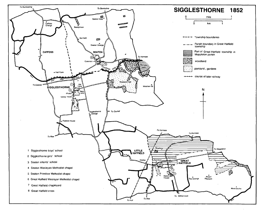
Sigglesthorne 1852
Sigglesthorne. The older buildings in Sigglesthorne village all lie along Main Street, and the church, on its west side, stands on one of the highest points in the parish. Back Lane and Old Lane run east from the street and join to form the Wassand road. The street has wide, grass verges, the large churchyard contains many trees, and the former rectory, Manor House, and Hall all have large, ornamental grounds. (fn. 17) A conservation area for the village was formed in 1986. (fn. 18) Gothic Terrace, in Back Lane, consists of four early 19th-century houses with a central pediment and pointed windows. Twenty-eight council houses were built in Main Street and on the Seaton road in the 1950s, and 23 more on the Wassand road c. 1970. (fn. 19) Other modern houses include an estate in Old Lane under construction in 1990 in fields where earthworks indicated old house sites. (fn. 20) An alehouse on Gott Gate was mentioned in 1724, and there was a beerhouse at Sigglesthorne in the mid 19th century. (fn. 21) A well dedicated to St. Lawrence formerly lay north of the Beverley road. (fn. 22) Two isolated farmhouses in the township were built between inclosure and 1829. (fn. 23)
CATFOSS hamlet consists of half a dozen houses on the Nunkeeling road, among them a farmhouse known as Catfoss Manor. Isolated to north and south are Catfoss Grange and Catfoss Hall Farm. There were only four houses by 1730. (fn. 24) Earthworks recorded in 1852 in garths beside the road may have marked the sites of other houses. (fn. 25) A camp was built at Catfoss by the R.A.F. on land bought in 1928. (fn. 26) The airfield was enlarged in 1939–40, the additions including land in Bewholme and Brandesburton. It was closed to flying in 1945 but was used as a missile site from 1959 to 1963. (fn. 27) It was sold in separate lots, mainly in 1965, (fn. 28) and a dozen houses built as married quarters, all in Catfoss, were later acquired by the district council.
GREAT HATFIELD. Most of the houses in Great Hatfield hamlet lie on the SigglesthorneWithernwick road. At the east end of Main Street stands the carved shaft and base of a medieval cross. (fn. 29) Small areas of common land lying beside the Mappleton and Sigglesthorne roads in the mid 19th century (fn. 30) were later inclosed. Houses built in the 20th century include 14 council houses. (fn. 31) There was usually one licensed house in the later 18th century. The Black Bull beerhouse was recorded in 1851 and an unnamed beerhouse in 1858. The Holderness Hunt inn was mentioned from 1879 until c. 1900, when it was renamed the Wry Garth; it still existed in 1990. (fn. 32) There are half a dozen scattered farmhouses in the township. The outlying houses formerly included one built in a close called Seats, near the boundary with Mappleton, by 1593. (fn. 33)
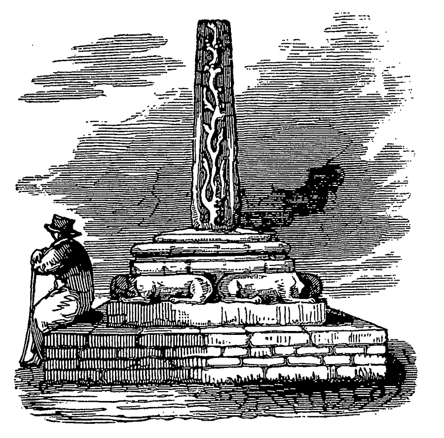
Great Hatfield Cross
LITTLE HATFIELD.In 1717 Little Hatfield hamlet comprised six houses standing beside the road from Sigglesthorne to Great Hatfield, but later there were only two or three; one isolated farmhouse was built after inclosure that year. (fn. 34)
SEATON.The houses of Seaton hamlet stand on the Beverley–Hornsea road, which forms Main Street, beside the Nunkeeling road, known in the hamlet as Breamer Lane, and in two back lanes. Small commons or greens adjoin Breamer Lane. The hamlet was said to have been much improved by John Maw (d. 1883) of Seaton House, who built several new cottages, (fn. 35) and further improvements were made by his successor W. P. Maw. (fn. 36) A children's playground was provided, a reading room was established in 1885, 33 cottage gardens were made available in 1886 and 11 allotments later, and public rooms were built in 1887. (fn. 37) Several ornate houses had also been built on the Hornsea road by the Strickland-Constables by 1890. (fn. 38) A conservation area in Seaton was designated in 1991. (fn. 39) There has been much infilling in the hamlet in the 20th century, and other houses have been built along the Sigglesthorne road, where a sewage pumping station was erected c. 1970. (fn. 40) There were usually one or two licensed houses at Seaton in the later 18th century; the Barrel was recorded in the 1820s, and the Swan or the White Swan has existed since at least 1839. (fn. 41) The White Swan lodge of the Oddfellows was established in 1869 and still existed in 1940. (fn. 42) A wooden, recreation hall was erected on a site in Main Street provided by the Strickland-Constables in 1935. (fn. 43) The former infants' school was used as a men's institute in the 1950s and 1960s. (fn. 44) There are half a dozen scattered farmhouses in the township.
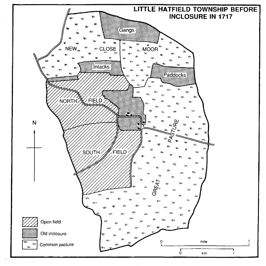
Little Hatfield township before inclosure in 1717
WASSAND. The approach to Wassand Hall from the Beverley–Hornsea road is partly along a raised causeway across the low-lying ground at the end of Hornsea mere. The small park made around the 17th-century house was improved and considerably enlarged after the building of the new house in the early 19th century. (fn. 45) Tree planting was also carried on outside the park, notably on land left by the receding mere: a plantation running along the boundary with Hornsea, north of the main road, was made c. 1812; the later Low wood, of c. 30 a., and Decoy plantation, both already enclosed with trees in 1809, had been planted by the middle of the century, and the planting of the northern edge of the mere was complete by the late 19th century. Other changes made when Wassand Hall was built included the reduction of the two farmsteads near by to one and the building of a new farmhouse, Weatherhill Farm, to the east of the park in 1814. A cottage ornée, Mushroom Cottage, had been built just over the Hornsea boundary in 1812, West Lodge towards Sigglesthorne was added in 1815 and in 1830 East Lodge towards Seaton, and in the mid 19th century three cottages were put up on the Hornsea road, opposite the northern entrance to the Hall. (fn. 46)
MANORS AND OTHER ESTATES
Except for Sigglesthorne, all of the townships were held in 1086 by Drew de Bevrère and later became part of the Aumale fee. (fn. 47)
In 1086 the archbishop of York held a berewick of 8 carucates at Sigglesthorne; by then the estate had been assigned to his church of St. John at Beverley, (fn. 48) and the provost of Beverley was granted free warren in SIGGLESTHORNE manor in 1314. (fn. 49) Tenants of the provost c. 1370 included Sir Amand of Routh, who held 1 carucate of the fee in Sigglesthorne. (fn. 50)
After the suppression of Beverley college in 1548 the Crown granted 4 bovates in Sigglesthorne, formerly belonging to the provost, to Christopher Estoft and Thomas Doweman or Dolman, (fn. 51) and in 1614 William Whitmore and Edmund Sawyer were granted the provost's former manor of Sigglesthorne. (fn. 52) The manor later passed to the Ingrams, and in 1633 Sir Arthur Ingram, Sir William Ingram, and John Ibson conveyed it, then including 5 bovates of demesne and 2 carucates of other land, to Henry Blashall and George Gibson the elder. The next year the manor was divided in moieties, Blashall taking 7 bovates and rents from 6 bovates and Gibson 5 bovates and rents from 5 bovates. (fn. 53)
In 1689 Blashall conveyed his half of the manor to Ralph Rand. The latter soon after sold it to Matthew Gibson, (fn. 54) who was one of the lords of the manor in 1705. (fn. 55) After Gibson's death his son Robert sold the moiety in 1731 to Hugh Bethell. (fn. 56) Bethell had bought 5 bovates which had belonged to the Constables of Catfoss in 1726, and in 1733 he acquired another 5 bovates from Arthur Smithson, together with several smaller holdings in the township. (fn. 57) At inclosure in 1781 William Bethell was allotted 254 a., and he bought a further 102 a. from Wakefield Simpson in 1793. (fn. 58) The estate descended in the Bethell family, who had 371 a. in Sigglesthorne in 1852 and 424 a. in 1915; the 129-a. Manor farm was sold in 1929 to Frederick Bird, but the Bethells still had c. 250 a. in 1990. (fn. 59)
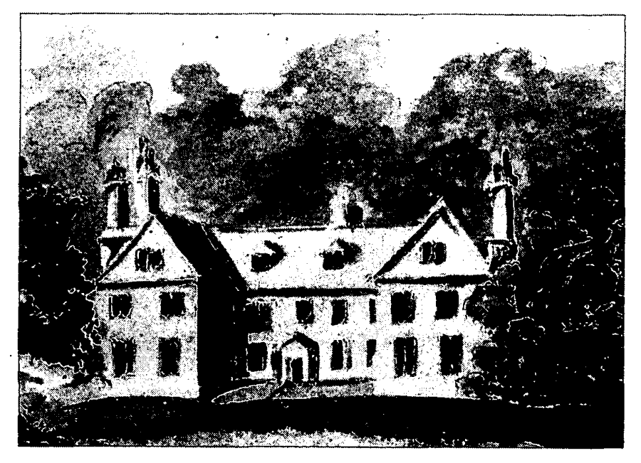
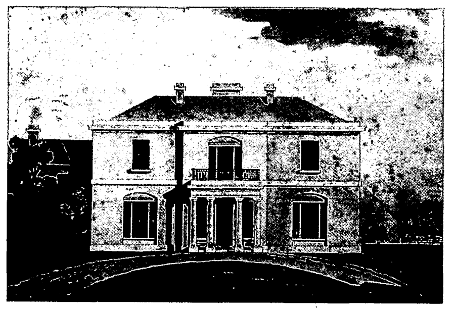
Wassand
WaterColour Of Former Manor House
A mansion house in which Matthew and Robert Gibson lived was mentioned in 1711. (fn. 60) Manor Farm, later called Manor House, is said to have been built near the site of the old house. (fn. 61) A depression at the roadside may be the remains of a moat.
George Gibson's share of the manor evidently passed to his grandson George Gibson the younger, who was the other lord of the manor in 1705. (fn. 62) Another George Gibson was allotted 99 a. at inclosure in 1781, and he increased his holding in Sigglesthorne in 1787. (fn. 63) The estate was devised by George Gibson (d. 1809) to his brother Matthew T. Gibson (d. 1833), who left it to George Gibson Richardson; it comprised a mansion house and 156 a. in 1837, when it was mortgaged by Richardson, along with another 46 a. In 1850 Richardson sold the whole estate to William, later Sir William, Wright (d. 1884). (fn. 64)
The Wrights sold Sigglesthorne Hall and 18 a. adjoining to R. V. S. Riall in 1888, and the nearby Hall Farm and 130 a. to John Haggas in 1889. (fn. 65) The Hall was sold twice in 1892, by Riall to Henry Strickland-Constable and by him to G. R. Bethell, who bought a further 46 a. from the Wrights in 1898. (fn. 66) After Bethell's death in 1919 his executors sold the estate in 1920 to David C. Smith, (fn. 67) who bought Hall farm in 1936. (fn. 68) Smith died in 1971, and the following year his executors sold the farm to John L. Spooner and the Hall to John E. and Jennifer A. Townend, who were still the owners in 1990. (fn. 69)
The Hall was built by Matthew T. Gibson early in the 19th century, when it comprised a 3-bay, central block with small, single-storeyed wings. It was enlarged in the early 1850s by William Wright, who raised the wings, added canted bays and a new north front, and remodelled the interior, under the supervision of Cuthbert Brodrick. (fn. 70) The house is of grey brick with stucco dressings. It contains some 18thcentury fittings from the former Red Hall at Winestead. (fn. 71) There is an early 19th-century stable block.
The chapter of St. John's college evidently had an interest in the archbishop's estate in Sigglesthorne, and after the suppression fee farm rents in the township formed part of the manor of Beverley Chapter, which was made up of former college property. (fn. 72) A small estate in Sigglesthorne also belonged to St. Mary's abbey, York. Sir Robert Constable (d. 1488) held 3 bovates there of the abbey. (fn. 73) Land at Sigglesthorne belonged to a chantry in the chapel at Great Kelk, in Foston on the Wolds, (fn. 74) and Henry of Weighton was licensed in 1336 to give land in Sigglesthorne to sustain a chaplain in the chapel at Gardham, in Cherry Burton. (fn. 75)
In 1066 Knut held 6 carucates comprising CATFOSS manor. The estate evidently passed to William Malet, who was deprived c. 1070. By 1086 it was held by Drew de Bevrère's man Franco, ancestor of the Fauconbergs, (fn. 76) and in the 1280s Walter de Fauconberg, later Lord Fauconberg, was recorded as the undertenant. Catfoss had evidently been granted to a cadet of the family before 1295, when William de Fauconberg was found to have held by knight service of Walter de Fauconberg 4 carucates and 3 bovates in demesne and 1 carucate and 7 bovates more occupied by his tenants. William was then succeeded by his son John, who granted Catfoss to his brother Henry. (fn. 77) Henry had a grant of free warren at Catfoss in 1324. (fn. 78) Sir Henry Fauconberg, perhaps the same, is said to have released his right in the manor in 1329–30 to Fulk Constable, who had married Henry's daughter Agnes. (fn. 79) Catfoss thereafter descended in the Constable family of Catfoss, which held it of the Fauconbergs and their successors as an appurtenance of Rise manor. (fn. 80) The heirs of Sir Robert Constable (d. 1720) sold the estate to Hugh Bethell in 1726, when it comprised c. 410 a. (fn. 81)
The Bethells had 1,051 a. in Catfoss in 1730 and 1839 (fn. 82) and 1,079 a. in 1915; part of Grange farm was sold in 1928, the rest, comprising 332 a., to Arthur F. Hainsworth in 1943, and the 296-a. Manor farm, to Frank Smith, in 1947. The Bethell estate still included c. 300 a. in Catfoss in 1990. (fn. 83)
A chief house was mentioned in 1295. (fn. 84) The manor house is said to have been rebuilt by Mary, wife of John Constable (d. 1659), (fn. 85) and it had 10 hearths in 1672. (fn. 86) Catfoss Hall, as it was sometimes called, was included in the sale to Bethell in 1726. (fn. 87) It is said to have been demolished in 1815 and the outbuildings converted to a farmhouse, (fn. 88) which was itself later called Catfoss Hall.
At unknown date part of the estate was separated from the rest. Sometimes called North Catfoss manor, it belonged to Richard Remington (d. by 1616), who was succeeded in turn by his son Richard and, by 1649, his grandson Sir Thomas; it comprised c. 500 a. in 1639. (fn. 89) It was sold by Sir Thomas and Richard Remington in 1672 to Richard Bethell, who conveyed it to Hugh Bethell in 1683. (fn. 90)
Nunkeeling priory had land in Catfoss worth 16s. a year in 1535. (fn. 91)
In 1066 Redhe held 2 carucates and 3 bovates comprising the manor of GREAT HATFIELD, and Morkar 2 carucates and 6 bovates there as soke of his manor of Mappleton. In 1086 the manor was held by Drew de Bevrère's man Walter. (fn. 92) In the 1280s the manor was held by Geoffrey Berchaud's heir as undertenant, and other estates there by William de Chestrunt and Walter de Fauconberg, later Lord Fauconberg. (fn. 93) In 1316 Walter of Hatfield and Walter de Fauconberg, Lord Fauconberg, were named as lords of Great Hatfield and its members. (fn. 94) Fauconberg's estate evidently continued to descend like Rise manor, passing eventually to the Crown. (fn. 95)
The manor descended in the Hatfield family until the early 16th century, when Maud, daughter and heir of John Hatfield, married William Constable. (fn. 96) The estate was evidently enlarged with the land of Robert Stokes (d. 1506). (fn. 97) The manor was held by the Constables of Hatfield, in 1572 it was said of the Crown's manor of Hampton (Mdx.) in socage, (fn. 98) until 1632, when Christopher Constable settled it on his daughter Jane upon her marriage to John Lister. (fn. 99) In 1700 another John Lister and his wife conveyed it to William Dickinson (d. 1702), who devised it to his granddaughter Sarah, widow of Hugh Bethell (d. 1717). (fn. 100)
The Bethell family's estate in Great Hatfield comprised 688 a. in 1767, slightly more c. 1840, and 780 a. by 1915. (fn. 101) Three farms were sold in 1930, including the 107-a. Manor farm to Cecil E. Appleyard, and nothing remained after the sale in 1942 of the 292-a. Mount Pleasant farm to L. A. North and the 252-a. Grange farm to John R. Rawson. (fn. 102)
The chief house of the manor was mentioned in 1632. (fn. 103) Its remains are said to have been converted to a farmhouse, (fn. 104) later called Manor Farm. The present Manor Farm is a brick and pantile house, possibly of the 18th century.
William de Chestrunt's estate in Great Hatfield evidently passed, like Holmpton, to Bolton priory (Yorks. W.R.) in 1310. (fn. 105)
A holding in Great Hatfield built up by the Midgley family in the earlier 18th century (fn. 106) passed at the death of Jonathan Midgley in 1778 to his widow Mary (d. 1791), and then to their daughter Mary, wife of William Beverley. (fn. 107) In 1837 R. M. Beverley sold a 248-a. farm in Great Hatfield and Cowden to Jesse Bowlby, from whose trustees W. H. Harrison-Broadley bought it in 1870. (fn. 108) In 1920 J. B. Harrison-Broadley sold the farm to William W. North (d. 1937), and it was later called Wood farm. (fn. 109)
Meaux abbey was given 1½ bovate and a close in Great Hatfield by William Tele and Baldwin Tyrrell, but sold them c. 1215. Simon de Rupella gave the service of Gilbert de Monceaux from 1 carucate in the township, but the service was released by the abbey c. 1240. (fn. 110) Nunkeeling priory was given land and tenants in Hatfield, probably Great Hatfield, by William of Anlaby and Simon de Rupella's relict, Beatrice, wife of Amand the butler. (fn. 111)
A chief house, several cottages, and 7 bovates of land in Great Hatfield held by Roger Kirkby (d. 1593) were said to have formerly belonged to St. Mary's chantry in Burstall church, in Skeffling. (fn. 112)
In 1066 Ketilfrith and Ramkel held 3 carucates comprising LITTLE HATFIELD manor; by 1086 they were occupied by Drew de Bevrère's man Rayner. (fn. 113) Little Hatfield was later held by the Areins family as undertenant. It belonged c. 1200 to William de Areins, who was succeeded in turn by his sons Arnold, Thomas, and Bernard, and then by Bernard's son Thomas, who held it in the 1280s. Thomas gave his estate in the township to Sir Robert Tilliol, (fn. 114) who held it at his death c. 1320; when Robert's widow Maud died in 1343, it descended to Robert's son Peter. Maud Tilliol's first husband had been Sir William Hilton, (fn. 115) and the estate had evidently come to Maud's great-grandson Sir Robert Hilton by the late 14th century. Little Hatfield later descended, like Swine, from the Hiltons to the Meltons and so to the Darcy family. (fn. 116)
Little Hatfield manor was held by Dorothy Darcy (d. 1557) and her husband George (d. 1558), Lord Darcy, (fn. 117) whose great-grandson John Darcy (d. 1635), Lord Darcy, conveyed it in 1606 to William Hustler. (fn. 118) Hustler was succeeded by his son William in 1644, (fn. 119) and in 1694 Sir William Hustler sold the manor to Robert Greame. (fn. 120) The estate, which comprised the whole township apart from the glebe land, amounted to 931 a. in 1842. (fn. 121) It descended in the Greame, later the Lloyd Greame, family until 1921, when Yarburgh Lloyd Greame sold one holding of 582 a., later called Middle farm, to James Swales, and another of 366 a., later called Manor farm, to Frederick Nettleton. (fn. 122)
A chief house was mentioned in 1687. (fn. 123)
Meaux abbey was given 5 bovates in Little Hatfield by William de Areins c. 1200, 2 bovates by his grandson Thomas, 1 carucate by members of the Routh family, who had acquired them from the Areinses, and 3 bovates by John de Ousefleet. (fn. 124) The abbey had a grant of free warren in Hatfield in 1293. (fn. 125) Its estate there was worth £3 5s. a year in 1535. (fn. 126)
In 1066 Svartgeirr and Ulf held 6½ carucates comprising two manors of SEATON; in 1086 Drew de Bevrère's man Robert occupied all or part of the land. (fn. 127) In the 1280s Seaton was held by William de Lasceles and William Whittick as undertenants. (fn. 128) In 1316 Richard of Tharlesthorpe and Walter de 'Whityng', presumably for Whittick, were named as two of the lords of Seaton and its members, (fn. 129) and in 1339 land in Seaton was held of William Whittick. (fn. 130) About 1350 most of Seaton was said to belong to Sir Walter de Fauconberg as of the Lasceles fee. (fn. 131)
The many small estates in the township in the 18th century included that of William Leake, which passed to his brother, the Revd. Thomas Leake (d. 1786 or 1787), and then to their nephew William Moxon (d. by 1854). The estate was sold in 1859 to George Taylor; it then comprised 171 a. and included 29 a. later known as Manor farm. (fn. 132) Taylor was described as lord of Seaton in 1879. (fn. 133) He died in 1880, and his 146-a. estate, including Manor farm, passed to his brother Richard Taylor and his nephew Harry T. Bateson; it was sold to Henry StricklandConstable of Wassand in 1894. (fn. 134) The Constables had 275 a. in Seaton in 1843, and by 1910 the estate of the Strickland-Constables included c. 515 a. there. (fn. 135) The holding was much the same in 1990, and then included Bassymoor, Buttercup, and Seaton Hold farms, besides Manor farm. (fn. 136)
In 1843 John Maw, a Hull draper, bought a house at Seaton which had been built c. 1825, and was known as Seaton House or Hall in the 1840s; a curate lived there in 1846 but Maw himself by 1858. (fn. 137) He died in 1883 and was succeeded by William P. Maw. (fn. 138) The estate comprised the house and 161 a. in 1902, when it was conveyed to Herbert F. Milvain. It was divided and sold later, some lots before Milvain's death in 1937 but 86 a. in 1958. (fn. 139) Seaton House, of grey brick, has a three-bayed centre with a Doric porch, flanked by deeply recessed wings of one bay.
Meaux abbey received many gifts in Seaton. William de Areins gave 3 bovates and William son of Godfrey of Seaton 6 a. c. 1200; John de Lasceles a close c. 1215; Stephen of Thorpe 5s. rent from 2 bovates, Richard Lorrimer 1 carucate and 2 bovates, Robert son of Odo of Seaton 5 a., Amfrid the noble a toft and croft, Peter son of Robert of Seaton 2 selions, and various benefactors 6 selions and other parcels of land c. 1240, and Peter son of Robert of Seaton a toft, a croft, and 1 a. and Nicholas son of Albreda of Seaton ½ bovate c. 1260. The estate in Seaton was farmed as part of the abbey's grange of Wassand. (fn. 140)
Nunkeeling priory was also given land and rents in Seaton. (fn. 141)
The provost of Beverley had an estate at Seaton which his heir, the Crown, held as a manor in 1572. (fn. 142)
In 1066 Sven held 2 carucates comprising the manor of WASSAND; in 1086 it was occupied by Drew de Bevrère's man Thorsten. (fn. 143) In 1287 Wassand was held as mesne lord by Geoffrey Berchaud's heir. (fn. 144) By the early 13th century the Wassand family held at least part of the manor in demesne, and in 1252 Roger of Wassand and Robert son of James of Wassand had estates there. (fn. 145) In 1316 Robert of Wassand was named as one of the lords in Seaton and its members, and by 1346 Thomas of Wassand had been succeeded by John of Wassand. (fn. 146)
The manor later belonged to Sir John Godard (d. 1420), from whom it evidently descended, like a share in Atwick manor, to the Ughtreds. (fn. 147) Sir Robert Ughtred (d. 1472) held ⅓; of Wassand manor, and Sir Henry Ughtred (d. 1510) all of it. (fn. 148) Sir Henry's son Sir Robert Ughtred later conveyed it to Robert Hodgson, subject to the payment of £13 6s. 8d. a year, for which Hodgson compounded in 1524. (fn. 149) Hodgson sold the manor in 1529 to Joan, widow of Sir William Constable of Caythorpe, in Rudston, and her son Marmaduke. (fn. 150) The manor, sometimes called Great Wassand, descended in the Constables of Wassand, who in 1841 had 506 a. in the township. (fn. 151) On the death in 1852 of the Revd. Charles Constable the estate passed to Sir George Strickland, Bt., who had married Constable's daughter Mary. Their son Henry took the additional surname Constable in 1863, and thereafter Wassand descended in the StricklandConstable family. Sir Henry Marmaduke Strickland-Constable, Bt. (d. 1975), was succeeded in the estate by his widow, Lady (Ernestine) Strickland-Constable (d. 1995), and she by trustees including her and Sir Henry's great-nephew Rupert Russell. (fn. 152) The estate comprised c. 520 a. in Wassand in 1910, (fn. 153) and much the same in 1990, when it included Home and Weatherhill farms, besides the park and woodlands. (fn. 154)
A manor house is said to have been built by Mary, wife of Philip Constable (d. 1618), (fn. 155) and the Constables had a house with 10 hearths in 1672. (fn. 156) The building, which had a U-shaped plan with gabled wings, (fn. 157) was renovated in the 1770s. The Revd. Charles Constable built a new house further south to designs by Thomas Cundy between 1813 and 1815, when the old house was demolished, and between 1821 and 1823 the service accommodation of the new house was extended by Watson & Pritchett of York. Wassand Hall is of white brick with stone dressings. The original three-bayed entrance front, to the west, had a Tuscan porch which was removed in the late 19th century. In 1947–8 the north elevation of the Hall was remodelled, the southern and western fronts were restored, and the greater part of the service wings was removed. A new stable block was built in the early 19th century with the house, an icehouse was made in 1818, and c. 1820 a later demolished cottage ornée was erected on Lady Island in the mere. (fn. 158)
The early house had a small park made from former open-field land. Some tree planting seems to have been done in the earlier 18th century, but there was much more a century later, following the building of Wassand Hall and the extension of the park westwards, which more than doubled its area. (fn. 159)
By the mid 12th century St. Mary's abbey, York, had been given 1 carucate at Wassand by Jocelin, (fn. 160) and its estate there was mentioned again in the mid 13th century. (fn. 161) Great Wassand manor was said to be held of the abbey by the Ughtreds, and at the death of Marmaduke Constable in 1568 it was believed to have belonged formerly to the abbey. (fn. 162)
Henry of Wassand gave Meaux abbey 2 bovates and a toft in Wassand and Robert Stanere another bovate c. 1200, and Robert of Wassand added a close and 3 a. there c. 1215. (fn. 163) Meaux was granted free warren at Wassand in 1293. (fn. 164) The abbey's grange of Wassand included its land in Seaton, and in 1535 the estate in both places was worth £7 5s. 9d. a year. (fn. 165) The Crown granted 3 bovates, a house, a croft, and 2 closes in Wassand, formerly belonging to the abbey, to John Brown and Thomas Wood in 1557. (fn. 166) They later became part of Wassand manor.
Wassand
West Elevation of Wassand Hall by Thomas Cundy, Built Between 1813 and 1815
ECONOMIC HISTORY
COMMON LANDS AND INCLOSURE. All the townships presumably had their own open fields, and from early times some of the low-lying ground was used as meadow land: there was meadow, varying from 6 a. to 30 a., in each township in 1086. (fn. 167)
Sigglesthorne. The open fields of Sigglesthorne were called East and West fields in 1650, when they included furlongs known as East and West Gravels and East and West Pastures, (fn. 168) suggesting that some of the township's common pasture was then in cultivation. Men were appointed in 1711 to investigate means of getting rid of water so as to keep the two open fields as dry as possible; it was also agreed to stint the common pasture at 1½ gates for each bovate, the same rate as the previous year. (fn. 169) In 1718 East field contained 335 a., West field 284 a., Gravels 112 a., the Pasture 228 a., and Mill hill 6 a., (fn. 170) Gravels, the land use of which is uncertain, lay north of the village and the Pasture occupied the southern end of the township. (fn. 171)
The remaining commonable land in Sigglesthorne township was inclosed by an award of 1781 under an Act of 1772. (fn. 172) The award dealt with 934 a. and the commissioners allotted a total of 899 a. The minimum areas of the grounds inclosed were 233 a. in West field, 182 a. in East field, 104 a. in West pasture, 90 a. in Gravels, and 47 a. in East pasture. The rector received 101 a. for glebe and tithes, William Bethell 254 a., William Smith's executors 105 a., George Carrick's executors 102 a., and George Gibson 99 a. There were also ten allotments of 10–39 a. and eleven of under 10 a., including a 2-a. common allotment for gravel digging.
Other townships. Catfoss, Great Hatfield, and Wassand were inclosed at unknown dates, Seaton in 1657, (fn. 173) and Little Hatfield in 1717. The whole manor of Catfoss was in closes in 1639. (fn. 174) The East field of Great Hatfield, recorded in 1601, may then have been inclosed. An estate there in 1593 had included several closes, including Great Mask and Seats, and in 1632 closes called West field and Intacke were part of the manor. (fn. 175) At Wassand the commonable lands included ground called North green, near the mere. (fn. 176) Roger of Wassand and Alan le Ros were found c. 1250 to have inclosed c. 10 a. of pasture at Wassand, depriving Robert of Staverne of common rights there. (fn. 177) The remaining commonable land at Wassand may have been inclosed in the mid 17th century, and ridge and furrow lying west and south of the Hall later marked the location of some of the settlement's tillage. (fn. 178) At Little Hatfield there was already more than 100 a. of old inclosures, including East and West Gengs, Great and Little Intacks, and East and West Paddocks, in 1717; practically the whole township then belonged to John Greame, and the remaining commonable land was divided among his three tenants and the rector of Sigglesthorne. The allotments comprised 137 a. from South field, 108 a. from North field, 395 a. from Great pasture, 79 a. from the Moor, and 101 a. from New close. (fn. 179) The last mentioned close existed by 1698 (fn. 180) but was evidently not held in severalty, for both before and after 1717 the rector held lands and gates in it. (fn. 181)
MEDIEVAL HOLDINGS. Meaux abbey set up a grange at Wassand, including its land at Seaton, c. 1200, and it also had a grange at Little Hatfield. (fn. 182)
WOODLAND. Nunkeeling priory was granted the right to take wood at Catfoss in the 13th century. (fn. 183)
FISHING. Meaux abbey claimed fishing rights in that part of Hornsea mere which lay in Seaton and Wassand, but in the mid 13th century it was forced to surrender them to St. Mary's abbey, York, the owner of the rights in the rest of the mere. (fn. 184)
LATER AGRICULTURE. In 1809 the estate of the Constables comprised 534 a. in Wassand, 275 a. in Seaton, and 7 a. in Sigglesthorne; there were then three farms, one of 222 a. and the others of 195 a., and six holdings of 6–13 a. (fn. 185) In the 19th and 20th centuries there were usually 4–5 farmers in Sigglesthorne, 3 in Catfoss, 7–10 in Great Hatfield, 2 in Little Hatfield, a dozen in Seaton, and 1 or 2 in Wassand; in the whole parish at least 12 in 1851 and c. 10 in the 1920s and 1930s had 150 a. or more. There were also 4 or 5 cowkeepers, 1 or 2 market gardeners, and 3 or 4 poultry farmers in the parish. (fn. 186) In 1987 of 37 holdings returned for Hatfield, Seaton, and Sigglesthorne civil parishes five were of 100–299 ha. (247–739 a.), ten of 50–99 ha. (123–245 a.), and twenty-two of under 50 ha. (fn. 187)
There was 1,549 a. under crops in the parish in 1801. (fn. 188) In Sigglesthorne, Catfoss, and Seaton and Wassand there were 2,430 a. of arable, 1,529 a. of grassland, and 86 a. of woodland, and in the Hatfields 1,575 a. of arable, 807 a. of grassland, and 20 a. of woodland in 1905. (fn. 189) In the 1930s much of the parish was arable, but there were large areas of grassland around the settlements, alongside Carr dike, and in Catfoss and Wassand townships. (fn. 190) In 1987 in Hatfield, Seaton, and Sigglesthorne civil parishes together 1,391 ha. (3,435 a.) were returned as arable and only 357 ha. (882 a.) as grassland, along with 12 ha. (30 a.) of woodland. There were then nearly 13,000 pigs, well over 8,000 poultry, and almost 700 each of cattle and sheep. (fn. 191)
FAIR. The provost of Beverley was granted a fair at Sigglesthorne in 1314, to be held on the eve, feast, and morrow of St. Lawrence (9– 11 August), and his right to its tolls was upheld c. 1350. (fn. 192) He was receiving the profits from the fair c. 1420, (fn. 193) but no more is known of it.
INDUSTRY. Bricks were made at Wassand in the mid 18th century, and several pits remain there, either from that activity or the digging of sand. (fn. 194) The only other industrial activity recorded in the parish was the commercial digging of gravel in Catfoss in the mid 20th century. (fn. 195)
MILLS. The holding of Sir Amand of Routh in Sigglesthorne included a mill c. 1370. (fn. 196) Windmills were recorded at Great Hatfield in 1264 and 1632, (fn. 197) at Little Hatfield in 1343, 1454–5, 1606, and 1687, (fn. 198) and at Sigglesthorne in 1600 and 1650. (fn. 199) There was also a mill at Seaton in the Middle Ages. (fn. 200)
LOCAL GOVERNMENT
The provost of Beverley, lord of Sigglesthorne, was said c. 1350 to have claimed liberties in four tenements in Seaton. (fn. 201) He received profits from a court at Sigglesthorne c. 1420. (fn. 202) In the 17th century the occupant of a house on Gott Gate was obliged to provide a room in which the manorial court of Sigglesthorne could be held. (fn. 203) Two affeerors were appointed in the manorial court c. 1610 (fn. 204) and again in 1740, when its other officers included 2 bylawmen, a constable, and a pinder. (fn. 205) Stocks and a whipping post in Sigglesthorne were replaced in 1828 by new stocks, which by the 1890s had also been removed. (fn. 206) Courts were held on the Meltons' manor at Little Hatfield in the 15th century. (fn. 207)
In 1730 the rector stated that there were usually 16 poor people in the parish, to each of whom he gave a bushel of wheat in winter and who all dined with him at Christmas; those in Sigglesthorne township also had daily and weekly charity from him, which he claimed was almost complete support for them. (fn. 208) In 1802–3 permanent out-relief was given to 26 people; half of them lived in Seaton township, where another 17 received occasional relief. In 1812–15 about 50 people were relieved permanently and c. 20 occasionally, about half of each group living in Seaton. (fn. 209) Sigglesthorne and the other townships, later civil parishes, joined Skirlaugh poor-law union in 1837, and a cottage formerly used to house the poor was sold in 1863. (fn. 210) The civil parishes were later part of Skirlaugh rural district, which was replaced in turn by Holderness rural district in 1935 and in 1974 by the Holderness district of Humberside. (fn. 211) In 1996 Sigglesthorne, Seaton, and Hatfield parishes became part of a new East Riding unitary area. (fn. 212)
CHURCH
There was a church at Sigglesthorne in 1086. (fn. 213) It was evidently assigned to St. John's college, Beverley, along with the arch bishop's estate in Sigglesthorne, and it was later in the peculiar jurisdiction of the college. (fn. 214) The benefice was united with Nunkeeling and Bewholme in 1972 (fn. 215) and also with Rise in 1974. (fn. 216) A chapel of Wassand within a house was mentioned in 1252. (fn. 217) A medieval chapel of Great Hatfield and a mission church built there in 1890 are discussed below. (fn. 218) Those parts of Mappleton parish which lay in Great Hatfield were annexed to Sigglesthorne parish in 1962, but both Great and Little Hatfield were transferred to Mappleton in 1972. (fn. 219)
The advowson belonged to the provost of Beverley until the suppression of the college in 1548, and thereafter to the Crown. After 1974 the patronage of the united benefice also belonged to the Crown, for whom the Lord Chancellor and the Prime Minister presented alternately. (fn. 220)
The church was worth £28 13s. 4d. a year in 1291 (fn. 221) and £29 14s. 5d. in 1535. (fn. 222) The improved value in 1650 was £145 net, (fn. 223) and c. 1700 the church was worth £180. (fn. 224) Net income averaged £685 a year between 1829 and 1831, (fn. 225) and it was £773 in 1883. (fn. 226) Tithes and offerings contributed £32 2s. 8d. to the gross value in 1535 and £144 in 1650. At the inclosure of Seaton in 1657 a rent charge of £34 was awarded to the rector for tithes, and in the 18th century the tithes of all the townships but Sigglesthorne were generally paid by composition. (fn. 227) When Sigglesthorne was inclosed in 1781, an allotment of 55 a. and a rent charge of £44 9s. 0½d. were awarded for tithes. (fn. 228) The tithes of Catfoss, Great and Little Hatfield, and Seaton and Wassand were commuted between 1839 and 1843 by separate awards for rent charges totalling £711 15s. 6d. (fn. 229) Glebe land and the parsonage house were worth £1 13s. 4d. a year in 1535 and £8 in 1650, when the glebe included a cottage, 3 closes, and 4 bovates in Sigglesthorne. At inclosure there in 1781 the rector was allotted 46 a. for glebe. (fn. 230) The rector also had several parcels of land and pasture gates in Little Hatfield; at inclosure in 1717 the glebe comprised 5 a. and gates in certain closes, but by 1842 there were 13 a., still in several parcels. (fn. 231) The rector sold 81 a. of glebe in Sigglesthorne and 13 a., by then consolidated, in Little Hat field in 1921. (fn. 232) There was still 20 a. unsold in Sigglesthorne in 1978. (fn. 233) The parsonage house, which had been described as in decay in 1623, had 9 hearths in 1672. (fn. 234) A large, new house was built nearby in 1767, and the ornamental grounds were later enlarged to cover 5 a. The house consists of a seven-bayed front range and rear wings. It was replaced by a new rectory house in 1969 (fn. 235) and was sold that year. (fn. 236)
A guild priest in the church was mentioned in 1538, and property in Catfoss formerly belonging to the Lady guild in Sigglesthorne church was granted to John and William Marsh in 1576. (fn. 237) A cottage given for an obit in the church was granted to Francis Morrice and Francis Phillips in 1609. (fn. 238)
A chapel of St. Helen at Great Hatfield was recorded in 1492. (fn. 239) It was in decay in 1595–6 and only one sermon had been given there the previous year. Soon after that it fell down. In 1650 it was recommended that the chapel be rebuilt and Great and Little Hatfield made a separate parish, (fn. 240) but nothing was done. Ruins remained in 1764, (fn. 241) and the former chapel yard, on the Withernwick road, was still used for burials in 1990.
The incumbents of Sigglesthorne have included several with other preferments who lived elsewhere. Robert Monceaux, rector in 1418, was a non-resident student in minor orders and Fulk Birmingham, rector c. 1438, a royal servant who held many Church offices. (fn. 242) In 1535 a Dr. Trafford was rector but his duty was done by a deacon, whom he paid £1 6s. 8d. a year; it was probably the stipendiary who was referred to as the curate in 1538. (fn. 243) Thomas Law, rector from 1657, was ejected in 1662. (fn. 244) Two assistant curates were employed in the 1860s and one c. 1890. (fn. 245)
By 1743 services were held twice on Sundays, and communion was celebrated six times a year with 50–60 communicants. (fn. 246) Some 25 received at the monthly communions in the later 19th century and c. 40 at the weekly celebrations in the 1920s. (fn. 247) The boys', girls', and infants' schools were licensed for services in 1848, when the church was being restored. (fn. 248)
A mission church, comprising chancel, nave, porch, and bell turret, was opened in Main Street at Great Hatfield in 1890, and in 1892 a service was held there each Sunday. (fn. 249) The church was used until 1952 and then again, after refitting with furnishings from the bomb-damaged Christ Church, Hull, from 1961 (fn. 250) until 1980. A monthly Anglican service later held in the Methodist chapel ceased early in 1990. (fn. 251) The former mission church has been converted to a house.
The church of ST. LAWRENCE, so called in 1393, (fn. 252) is built of boulders with ashlar dressings, and has been much repaired with brick. It consists of chancel with north vestry, aisled and clerestoried nave with south porch and south chapel, or transept, and west tower. Much of the fabric dates from the 13th century, when the church comprised chancel, nave with transepts and narrow, three-bayed aisles, and west tower. The porch is the only later-medieval addition.
The chancel was said to be in decay in 1575 and was substantially rebuilt in brick soon after that. One of the aisles was in disrepair in 1595–6, (fn. 253) and about that date the brick clerestory was probably added. The tower was restored in 1676, and battlements were added to the south aisle in 1714. (fn. 254) Repairs to the tower in 1763 were so expensive that steps were taken to oblige parishioners living in Great Hatfield to pay church rates, a burden which they had hitherto avoided. (fn. 255) A gallery was erected in 1822, replacing a loft of 1712. The north aisle was rebuilt in 1827; (fn. 256) the work involved the demolition of the transept, which is probably to be identified with the chapel of the Constables of Catfoss. (fn. 257) The tower was strengthened in 1842, and restoration of the church by J. L. Pearson in 1847–8 included new seating and the insertion of lancet windows. The tower was again restored in 1920. (fn. 258) A medieval, altar slab survives in the churchyard.
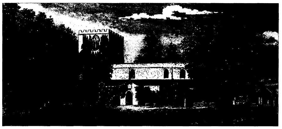
Sigglesthorne Church In The Earlier 19th Century
There were three bells in 1552 and later; they were recast in 1785 by James Harrison of Barrow on Humber (Lincs.). (fn. 259) The plate included a chalice in 1552 and a chalice with cover and a paten in 1720, when that chalice was replaced with another. (fn. 260) A new service was given by W. H. E. Bentinck, rector, in 1838; the flagon, made in 1639, was later lost but recovered. An almsdish was given in 1804. (fn. 261) The registers of baptisms, marriages, and burials begin in 1562 and are complete. (fn. 262)
An addition to the churchyard was consecrated in 1909. (fn. 263)
NONCONFORMITY
A few recusants and non-communicants were recorded in the parish from the late 16th to the 18th century, among them Christopher and John Constable at Hatfield in 1580–1. (fn. 264) In 1664 there were 4 recusants from Seaton, 2 from Hatfield, and 1 from Sigglesthorne, and the parish was said to include 2 popish and 8 other dissenters in 1676, and 6 papists in 1706. (fn. 265) Wassand Hall was registered for worship by Quakers in 1718, and a house in Seaton in 1740, (fn. 266) and there was one Quaker family in the parish in 1743 and 1764. (fn. 267)
At Seaton houses were licensed for nonconformist worship in 1758 and 1808. A Wesleyan Methodist chapel was built there in 1810 and enlarged in 1878, and a Primitive Methodist chapel was put up in 1837. (fn. 268) The Primitive Methodist chapel, later the Methodist church, was still used in 1990, when it had been recently enlarged. The former Wesleyan chapel was deregistered in 1949 (fn. 269) and later demolished.
A house at Great Hatfield was licensed for nonconformist worship in 1822. (fn. 270) A Wesleyan Methodist chapel was built there in 1838 and sold, after the 'failure of the cause', in 1885. (fn. 271) It was converted to a house but later demolished. (fn. 272) The Primitive Methodists licensed a building at Great Hatfield in 1860 and built a chapel there in 1862; it was enlarged, in red and yellow brick, in 1901 (fn. 273) and was still used by the Methodists in 1990.
EDUCATION
SIGGLESTHORNE
John Ganett, rector, paid a master to teach at Sigglesthorne in a schoolhouse which he had built, perhaps in 1723; in 1731 he pulled down the building because it was so wet, and the use of a rented house instead lasted for only a few years. (fn. 274) There was, however, a school in 1788, when John Day became master; he gave up the post in 1803 because the remuneration was too small but returned in 1812, when Marmaduke Constable left £400 for the education of children at Sigglesthorne or Seaton. Day enjoyed a local reputation as a poet. (fn. 275) A National school was built in 1813 and attended by 18 boys in 1818. (fn. 276)
HOLDERNESS WAPENTAKE
The master received c. £19 from Constable's bequest in 1818, and 15 of his pupils were taught free in 1823. (fn. 277) In 1833 there were 40–50 boys in attendance, and the income was £14 a year. (fn. 278) An annual parliamentary grant was received from 1859. (fn. 279)
A National school for girls was built in the churchyard at Sigglesthorne in 1818 by Mrs. Bentinck, the rector's wife, and supported by her; in 1833 the school's income came from subscriptions and the school pence of its 40–50 pupils. (fn. 280)
The boys' and girls' schools were replaced by a mixed school in Sigglesthorne, built in 1867. (fn. 281) The former boys' school was later demolished; that for girls was used as a nursery school in 1990 and still stood in 1998. The attendance of 48 on inspection day in 1871 included children from Goxhill. (fn. 282) The school benefited from Constable's charity and from that of W. H. E. Bentinck, rector (d. 1868), who left £1,700 for the education of children at Sigglesthorne and Seaton. In 1906 the income of Constable's bequest was £9 a year from £379 stock and of Bentinck's £47 from £1,826 stock. (fn. 283) The school was enlarged in 1894, and after amalgamation with an infants' school at Seaton in 1924 a classroom was added later that year. (fn. 284) Average attendance from 1906 to 1932 was usually 70–90; from 1935 to 1938 it was c. 55. (fn. 285) The senior pupils were transferred to the secondary school at Hornsea in 1958, (fn. 286) and in 1990 there were 54 pupils on the roll at Sigglesthorne. (fn. 287)
SEATON
One of the parish cottages at Seaton was used as a school in 1840, (fn. 288) perhaps for infants. A new infants' school was built there that year. It was supported by voluntary contributions, income from Bentinck's charity, and school pence, and in 1865 had an average attendance of 50. (fn. 289) From 1906 to 1922 average attendance was usually 30–40. (fn. 290) The school was amalgamated with the junior school at Sigglesthorne in 1924. (fn. 291) The former school was used as a storehouse in 1990.
In 1940 the endowment of Bentinck's charity comprised 2¼ a. at Seaton, the school playing field at Sigglesthorne, and £1,826 stock, producing an income of £51 a year. Land at Seaton was sold in 1960 and 1963, and that adjoining Sigglesthorne school to the county council in 1965. (fn. 292) The income from Bentinck's charity in 1989–90 was £310, from which payments totalling £249 were made, mainly to school funds and for student transport; the income from Constable's charity was then £13, but no payments were made. (fn. 293)
GREAT HATFIELD
A school was opened in 1894 in the mission church at Great Hatfield. (fn. 294) From 1906 to 1938 average attendance was usually 30–40. (fn. 295) In 1952 the village hall was rented as additional accommodation, (fn. 296) but in 1959 the school was closed and its pupils were transferred to Hornsea. (fn. 297) The building was later converted to a house.
CHARITIES FOR THE POOR
William Hopper, by will dated 1658, left 4s. a year from his house at Seaton, and Thomas and Mary Egglerton, by deed of 1676, gave 4s. a year from the same house, the monies in both cases to be distributed to the poor of Seaton and Wassand at Christmas. The income was so used in 1823. In the early 20th century the 8s. rent charge was used to make payments to a dozen people each year; the charity was still active in 1943 (fn. 298) but no more is known of it.
Three acres of common land at Seaton called the Whinn was assigned to the poor of the township for collecting fuel at inclosure in 1657; (fn. 299) it is not known what became of it.
William Day in 1616 gave £2 a year to the poor of Great Hatfield from land there. The income was distributed by the overseers in 1823. In the early 20th century the money was used to make payments to 2–6 people each year. The charity was wound-up c. 1990. (fn. 300)
Matthew T. Gibson, by will proved in 1833, left £400 for the poor. The income was £10–11 a year from £390 stock in the early 20th century, when the money was distributed to 20–30 people each year. In 1989–90 the same income was received and £10 was distributed at Christmas. W. H. E. Bentinck, rector (d. 1868), made a bequest for the upkeep of his grave and for the poor which produced £1 income in the early 20th century, when payments were occasionally made to 1 or 2 people. Income of £2 was received in 1989–90 but no payments were made. (fn. 301)