Survey of London: Volumes 43 and 44, Poplar, Blackwall and Isle of Dogs. Originally published by London County Council, London, 1994.
This free content was digitised by double rekeying. All rights reserved.
'Old Blackwall', in Survey of London: Volumes 43 and 44, Poplar, Blackwall and Isle of Dogs, (London, 1994) pp. 548-552. British History Online https://www.british-history.ac.uk/survey-london/vols43-4/pp548-552 [accessed 26 April 2024]
In this section
CHAPTER XVIII - Old Blackwall
The district around `Blackwall' Stairs was known as 'Blackwall' by at least the fourteenth century, but does not survive as a distinct area today. It was situated on the north bank of the Thames between the River Lea to the east and Coldharbour to the west, in a sheltered loop of the river, before the Thames turns soutwards past the eastern side of the Isle of Dogs. Settlement was confined chiefly to a street, known as Blackwall, which ran parallel to the river towards Coldharbour and was connected to Poplar High Street by Blackwall Causeway, the route of which is today represented by Brunswick Way. To the east of the Causeway lay Blackwall Yard, which was the biggest shipbuilding concern on the Thames during the seventeenth and eighteenth centuries, when it was the raison d'étre of Blackwall. In character and appearance Blackwall somewhat resembled Coldharbour (Plates 93a, c. 942). The area was transformed during the late nineteenth century, when the streets, inns and houses were swept away, and the original river wall now lies several hundred feet inland.
The Development of Blackwall
The earliest known reference to the site is in a document of 1362, in which meadow and pasture were leased at Godelockhope (Goodluck Hope) and Blackwall. (fn. 4) In 1377 it was called Blakewall. The wall was no doubt an artificial bank constructed beside the marsh to keep out the riverwater. (fn. 5) In 1593 John Norden stated that Blackwall took its name from 'the blackeness or darkeness of the bankes or wall at that place'. (fn. 6)
Until the development of the East India Docks at the beginning of the nineteenth century, Blackwall lay to the south-west of open fields known as the East Marsh of Poplar. There seems to have been little early settlement in the area, although a community of fishermen lived in the vicinity in the fourteenth century. This lack of development was no doubt partly due to its relative isolation. As far as land communication was concerned it was a dead end, for its only connection with the rest of Poplar was along an ancient trackway called Blackwall Causeway, which in 1725 was 1,122ft long on its west side and 1,076ft on its east, and 26ft wide. (fn. 7) At the southern end of the causeway were Blackwall Stairs, a common way consisting of a slipway and staircase leading down to the river.
In 1643 there was a complaint that the carts going along the causeway were damaging it, and the East India Company ordered a gate and a stile, 3ft high, to be erected at the northern end. Giles Sheppard was employed as a porter 'to keep the key of their gate' and no carts could pass through without a 2d payment. The money was to be used to repair the causeway. (fn. 8)
At the time of the Armada a proposal was put forward to construct a barrier across the river at Blackwall to prevent Spanish ships reaching the capital. This was presumably a boom of masts, chains and anchors. Robert Adams's map of the Thames of 1588 shows a barrier and a star-shaped fort at Blackwall, but there is no evidence that the fort was built. Similarly, some large piles running across the river reputedly were discovered in later years, but there is no certainty that the barrier was constructed. (fn. 9) A more permanent structure was planned soon afterwards, for a letter sent to Sir Robert Sydney in 1599 states that 'a bridge is to be made over the Thames at Blackwall'. (fn. 10) This was an ambitious plan; there was no bridge down-stream of Tower Bridge until the Queen Elizabeth II Bridge at Dartford was opened in 1991.
It was its advantage as an anchorage that was the spur to Blackwall's development. The moorings there were protected by Blackwall Rock, a reef about 300ft long and 150ft wide, which provided shelter for ships anchored offshore. (fn. 1) From the fifteenth century, Blackwall was the place where travellers wishing to avoid the long journey around the Isle of Dogs embarked and disembarked, and it also became a victualling point for outward-bound vessels. Its importance as an anchorage is indicated by the fact that in the late seventeenth century it was the most expensive one on the Thames. In 1684 the cost of mooring a ship on one of the three river-chains at Blackwall was 15s per week. (fn. 12)
During the sixteenth century Blackwall was the point of departure for many of the great voyages of discovery, including Frobisher's second voyage in search of the North West Passage. In 1606, the Virginia Settlers in the ships Susan Constant, Godspeed and Discovery set sail for America from Blackwall. A memorial to them was erected on Brunswick Wharf in 1928 (see page 598).
Another major element in the development of Blackwall was ship-repairing and later shipbuilding. During the late fifteenth and early sixteenth centuries repairs were carried out to both private and royal ships there. In 1485 the Cely family ship, the Margaret Cely, underwent repairs at Blackwall, and in 1512 the 450-ton Peter Pomegranate, one of the king's ships, was re-decked and caulked there. (fn. 13) The materials for repairing vessels of the Henrician navy overhauled at Blackwall were brought by barge along the Thames from London. At that date there were no permanent docks or slips at Blackwall, and so in 1514, 30 labourers and dykers spent four days 'dykynge and castyng' a dock for the Mary Rose when she came to Blackwall for repairs. (fn. 14)
Nevertheless, it was not until after 1614, when the East India Company's principal shipyard was constructed at Blackwall, that any major building development occurred in this part of Poplar. Although a few inns had already been built beside the river near to Blackwall Stairs, sixteenth-century Blackwall had not developed as a residential community.
In 1618 William Burrell (the principal shipwright to the East India Company) purchased the causeway at Blackwall for £100. (fn. 15) The East India Company wished to buy the eastern side of the causeway which lay alongside its yard, and a protracted battle arose over its ownership. Burrell obviously recognized the potential of the site for the construction of homes for men working in the yard, as he stated that he 'bought the rest with intent to build thereuppon to leave something in certain for the good of his children'. (fn. 16)
The Elders of Trinity House were consulted regarding Burrell's proposal to erect dwelling houses for seafaring men at Blackwall in case the buildings would be 'preiudiciall unto the Ryver'. In fact, they regarded the site as a 'fitt and convenient place for houses and buildings . . . in regard to the nearness of the East India workes and the number of ships there continually ryding'. (fn. 17) Thus, residential development at Blackwall commenced in earnest during the 1620s and 1630s, and it continued throughout the century as both the shipyard and overseas trade prospered and the demand for labour in the area increased.
In 1652 the East India Company sold Blackwall Yard, and the shipwright Henry Johnson became the owner of the premises. As the century progressed he extended the original yard northwards and eastwards, altering its physical appearance as the demands of the business grew (see page 556). Prosperity and expansion continued until 1718 and the death of the younger Henry Johnson. With the prosperity of the yard and the provisioning of ships going to the East Indies, a sizeable community had grown up at Blackwall by the late seventeenth century. In 1688, when the inhabitants were ordered to cleanse the common sewer behind their houses, there were at least 42 residents there. (fn. 18)
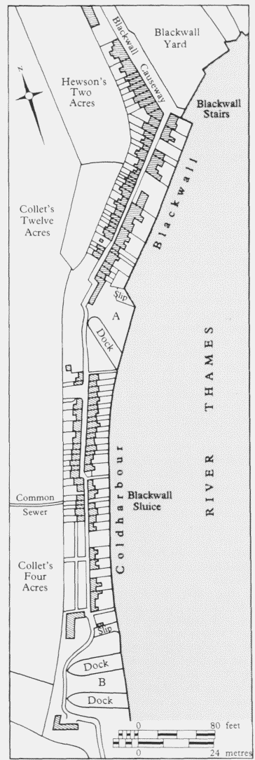
Old Blackwall and Coldharbour in 1740 A Samuel Hyde's yard and dry dock (formerly Henry Johnson's upper dock): B John Rolt's former yard and dry docks
Evidence for the houses in seventeenth-century Blackwall is scanty, although an inventory of a prosperous anchor-smith who died there in 1682 shows that at least one of them was three storeys high. On the ground floor was a kitchen (with a cellar), a parlour, a hall, and possibly a shop. The dining-room, the children's chamber and the 'best room up' were on the first floor, while there were at least four rooms on the second floor. (fn. 19)
The decline in the prosperity of the shipyard in the 1720s caused great poverty in Blackwall. Many local people were without work and some of those engaged in the shipbuilding trades left to seek employment elsewhere. The area did not expand again until the revival of the yard's fortunes later in the century and the construction of the East India Docks at the beginning of the nineteenth century. A map of 1740 shows the extent of development, with buildings on both sides of Blackwall High Street and to the western side of the causeway (fig. 206). (fn. 20)
Another feature for which Blackwall became noted was the Whitebait Suppers served in the inns there. These Suppers reputedly were begun at Breach House in Dagenham about 1721, by the commissioners responsible for repairing the river wall, (fn. 21) but they soon achieved a wider popularity and were held at Greenwich and Blackwall. For much of the nineteenth century the Cabinet attended an annual Whitebait Supper at Greenwich or Blackwall, and the Suppers became one of the events of the London 'season', patronized by such diverse bodies as the Court of the East India Company and the Fox Club. (fn. 22) At the height of its popularity as an eating place, during the first half of the nineteenth century, Blackwall had at least nine inns, five of them sited along the riverfront. They lay next to each other, vying for trade. In 1817 the riverside inns, westwards from the Stairs, were the King's Arms, Coach and Horses, Britannia, Plough, Artichoke and the George. (fn. 23) By 1837 the Royal Eagle Company was running boats hourly during the summer months from London to Blackwall, where whitebait was eaten by 'civilized persons, with no little gusto at the "Artichoke" or "Plough"'. (fn. 24)
In 1844 a major fire destroyed the Britannia Tavern, and damaged the Plough, the Artichoke, the India House Tavern, the King's Arms, the George, and two adjoining houses. This devastation resulted in the rebuilding of much of the riverside during the next few years, (fn. 25) but did not check the popularity of the inns as fashionable eating places. Samuel Lovegrove the younger, the proprietor of the Plough (and of other prominent hostelries in Blackwall), was described in 1857 as a 'renowned restaurateur' and the quality of his whitebait was much praised. (fn. 26) The inns also continued to benefit from the custom of travellers passing through the area. In 1845 'great quantities of persons' were said to embark and disembark to and from steam vessels at Blackwall Stairs Floating Pier. (fn. 27) From the 1860s Greenwich seems to have been the more popular venue, and the Whitebait Suppers at Blackwall were discontinued in the 1880s. (fn. 28)
Raleigh's House
Blackwall was the site of an ancient timber-framed house which became known, some time during the nineteenth century, as 'Raleigh's House'. It stood directly opposite the Artichoke Inn. Any association with the sixteenthcentury courtier and explorer is extremely tenuous, as is the further claim that the same property had been the residence of Sebastian Cabot. (fn. 29) Raleigh was indeed at Blackwall on many occasions, while waiting to go aboard ship or when on naval business. Many letters written by him are signed from Blackwall, but this is not proof that he was a permanent resident. (fn. 30)
A photograph of the house taken in 1873 shows it to have been a jettied timber-framed building infilled with lath and plaster (Plate 93b). (fn. 2) Wooden carvings of grotesque heads decorated the facade. The floor of the house was, by the late nineteenth century, below street level and the main entrance was blocked. As early as 1856 it was suggested that such a quaint house should be preserved and turned into 'a little almshouse or school'. (fn. 32) This advice was not heeded, and pressures to develop the area eventually led to the demolition of the building, which had been carried out by 1881. Its site was bought by the Metropolitan Board of Works from the London and North West Railway Company in 1888 for the construction of the Blackwall Tunnel. (fn. 33)
The Principal Inns
From the 1540s, if not before, a number of inns had existed at Blackwall to serve the needs of travellers. In 1618, soon after the East India Company came to the area, Blackwall Yard was threatened with flooding because of the 'decaye of the wharf by the Taverne' which lay between the yard and Blackwall Stairs. (fn. 34) In 1625 an inn known by the 'Signe of the Three Mariners in Blackwall' was mentioned in a case involving the theft of beef belonging to the East India Company. (fn. 35) Blackwall had another inn by the 1630s, when 'the signe of the Armes of the East India Company' was run by Zachary Gilby. (fn. 36)
The Globe Tavern (named after one of the first ships to have sailed from Blackwall Yard) was built to the north of Blackwall Yard some time between 1643 and 1656 and was described in 1656 as a 'messuage with stables and hay loft'. (fn. 37) The nine cottages in the tavern yard by the early eighteenth century had been rebuilt as twelve cottages by the 1840s, and in 1755 six almshouses were added there (see below).
In the early 1830s the Globe Tavern was the base for an extensive horse-omnibus company, owned by Onesiphorus Randall, who was to become an important speculative builder in Poplar (see page 207). When he sold the business in 1835 it included 26 horses, two 'well built omnibuses' and 'six nearly new flys, for six inside and outside passengers', as well as Blackwall Flys. (fn. 38) The whole of the Globe Tavern site was cleared for the construction of the Midland Railway Company's goods station in the late 1870s.
Several of the Blackwall hostelries were small public houses, but they included two inns of somewhat superior status, the Plough and the Artichoke, both of which became fashionable eating places during the middle decades of the eighteenth century and the principal venues for the Whitebait Suppers in the nineteenth.
The Plough, which first appears in the ratebooks in 1725, was arranged around a yard with a series of buildings on three sides. As well as stables there were various parlours and bars, and a tap-room. The inn could be entered from Blackwall High Street through the yard, or from the river via a small staircase that passed into the Plough Yard (fig. 207). (fn. 39) Between 1838 and 1840 the Plough underwent considerable alterations, and it was partially rebuilt in the mid-1840s, presumably prompted by the damage caused by the fire of 1844. (fn. 40) A plan of 1846 'for building an Extra Room over Entrance Hall' shows a much more sophisticated layout than in 1826. The stables had already been turned into a public room and the upper floors on the river side of the inn were being used as private dining-rooms and a large coffee room. The five bay windows on the first floor enabled the clientele to enjoy the fine prospect across the river. (fn. 41) An elevation drawn at the same time (1846) shows an Italianate treatment with a tripartite window (the heads filled with shell decoration), over a Doric portico. The architect of the Italianate additions was Henry Rose, who also designed the Licensed Victuallers' Asylum in the Old Kent Road and their school in Kennington. (fn. 42) The Plough was closed by 1861 and the building was demolished during the 1880s.
The Artichoke was built c1731. Joseph Woodcock took a 21-year lease of the building in 1744, at an annual rent of £15. (fn. 43) In 1754 the landlord, Peter Lord, advertised the opening of the Long Room as 'a fine place for seeing the ships launched', and further improvements were made in 1762. (fn. 44) During the eighteenth century the inn was the site of a coach office. (fn. 45) In 1861 the Artichoke, then tenanted by John Roberts, was evidently still a prosperous place, as nine servants were employed there. (fn. 46) It was purchased by the Metropolitan Board of Works from Messrs Charrington & Company in 1888, and the tenants were ordered to close the building to allow the construction of the Blackwall Tunnel to commence. (fn. 47) (fn. 3)
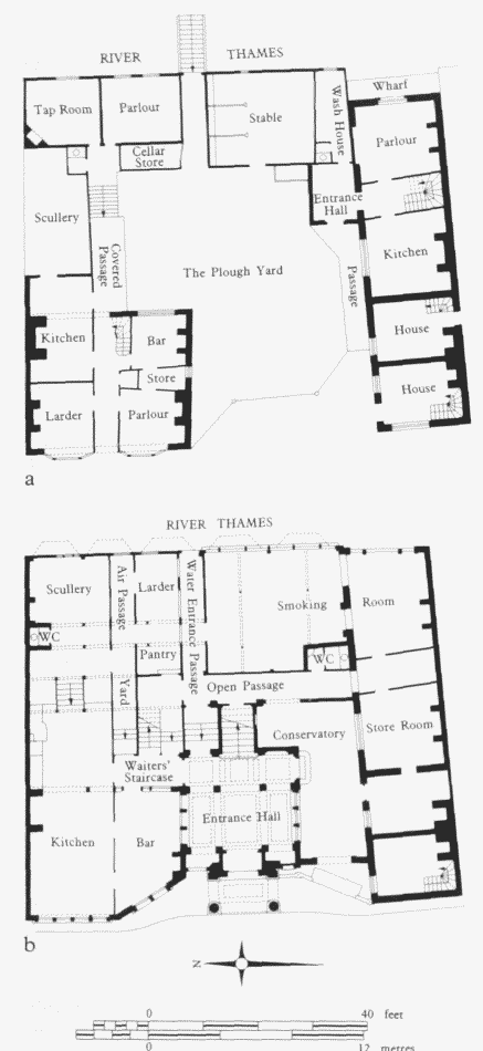
The Plough, Old Blackwall. Demolished a Ground-floor plan in 1826: b Ground-floor plan incorporating the alterations proposed by Henry Rose in 1846
Johnson's Almshouses. Globe Yard
In his will, drawn up in 1683, Sir Henry Johnson, the owner of Blackwall Yard, directed that within a year of his death his son, also Sir Henry, should build six almshouses, at a cost of £300. Each almshouse was to contain 'two rooms and a chimney'. They were to house poor and aged ship-carpenters, each of whom was to receive a weekly allowance of 2s 6d. Henry junior did not carry out the work, however, but he did allow seven of the nine cottages in the yard of the Globe Tavern to be occupied rent free 'in the nature of almshouses'. The obligation passed to John Kirby and his associates, who acquired Blackwall Yard in 1724 and were ordered by the Court of Chancery to erect the almshouses by the end of that year. (fn. 49) In fact, the six almshouses specified by Johnson were not erected until 1755, at the eastern end of the tavern yard, facing westwards, when Blackwall Yard was owned by Henry Crabb Boulton and Jonathan Pytts (see fig. 210). (fn. 50) The rebuilding of c1830 mentioned by Simmonds apparently refers to the earlier cottages in Globe Yard and not to the almshouses. (fn. 51) The almshouses were demolished when the Globe Tavern site was cleared in the late 1870s.
Industrial Sites
The presence of Blackwall Yard stimulated a number of other maritime-related developments in the area. From the early seventeenth century to the early nineteenth, the west side of Blackwall Causeway was occupied by a ropeground, over 1,200ft long and some 200ft in width. In 1678, on the death of the ropemaker John Bennett, it was valued at £40, including the sheds and warehouses. (fn. 52) Gascoyne's map of 1703 shows a single ropewalk here (see fig. 1, page 3). In 1728 the ropewalk's dimensions were given as 1,122ft by 28ft. (fn. 53) By the end of the eighteenth century a second ropewalk had been added and a third was built in the early nineteenth century. Horwood's map of 1813 shows the three ropewalks, but by then the whole of the ropeground had been handed over to builders for development (see page 624).
Apart from the activities of Blackwall Yard, ship-building and repair were undertaken at a smaller yard next to the Plough Inn. This small yard was held from c1717 until 1730 by the local shipbuilder John Rolt (see page 602). (fn. 54)
Also depicted on the map of 1703 is a shipyard called Johnson's Upper Dock. This was a small yard with just one single dry dock. During the seventeenth century it was called Coldharbour Dock and Henry Johnson held it on lease from William Stevens, the East India Company's shipwright. In 1678 Johnson and his partner William Christmas applied to the Conservancy Court for permission 'for a wharf incroached into the river of Thames at Coleharbour nere Blackwall'. (fn. 55) An earlier tenant had been James Avery, who had undertaken repairs for the Navy in 1671. (fn. 56) During the eighteenth century the yard was held by Samuel Hyde and, after 1785, by Richard Govey. Under the West India Dock Act, Johnson's Upper Dock, or Govey's Dock as it was now known, became the Blackwall Entrance to the West India Docks. (fn. 57)
Lying to the east of Blackwall Causeway, beside Blackwall Yard, was a wharf, which is shown on the map of 1703 (where it is numbered 4), and more clearly on a plan of 1812. During the late eighteenth century the wharf and accompanying 1½ acres were held as copyhold of the manor of Stepney by Thomas Newte. His executors auctioned the premises (called Lower Wharf) c1807. At that date the estate comprised 'a range of 4 warehouses, rigging houses, stable, other buildings, excellent crane' and 'a capital wharf 90 feet frontage to river'. (fn. 58)
A plan of 1834 shows the premises to be largely unchanged from the time of Thomas Newte. But a change of ownership had occurred, and the premises were now in the possession of Messrs J. Ashton & Sons. (fn. 59) Joseph Capp Ashton, a ship-chandler, remortgaged the premises for £3,410 in 1835, when it was stated that the warehouses and buildings had been built by Charles Raymond, esquire, on the site of the East India Arms. (fn. 60)
The End of Old Blackwall
Charles Booth's researchers visited Blackwall Harbour in 1887, when they reported that all the houses were condemned and that it was a wretched place inhabited by very poor people, except for 'a doubtful character at the coffee house'. Another man received special mention as he had the dubious occupation of selling 'opera glasses on race courses'. (fn. 61)
In 1897 Blackwall Highway was described in the Municipal Journal as being in a sorry state:
this riverside highway has fallen upon decadent days. The shops are small, and many of them tenantless; and little is left to suggest the sea. One or two general dealers still pose as ships' outfitters, and one or two shops remain as marine stores: but all in vain do they strive to preserve the old traditions. (fn. 62)
Much of old Blackwall was cleared for the construction of the Blackwall Tunnel, and the original river wall was extended several hundred feet into the river, creating a new riverfront by 1893. (fn. 63)